
| VICKSBURG TALLULAH RGNL TALLULAH LA |
| |
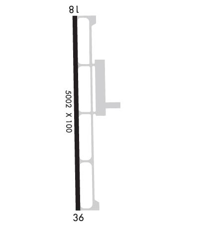
| Lat: N 3221.1 Long: W 09101.7 Elev: 86 Var: -02 Longest Runway: 5002 | ||
| Clr Del: 135.07 GCO AWOS: 118.52 CTAF: 123.0 | ||
| ||||||||||||||||||||||||||||||||||||||||||||
| ||||||||||||||||||||||||||||||||||||||||||||
| ||||||||||||||||||||||||||||||||||||||||||||
| Rwy | Rwy | |||||||
| 5002x100 | 5002' | 5002x100 | 5002' | 109.70 - 357° | ||||
| Runway ID | Single Wheel | Double Wheel | Double Tandem Wheel | Dual Double Wheel |
| 18/36 | 60,000 | 75,000 | N/A | N/A |
| These numbers are Advisory and are not limits. The Airport Manager should have more accurate Weight Limits | ||||
 Airport Diagram might not be current. | |
| Facility Name: | VICKSBURG TALLULAH RGNL |
| City Name: | TALLULAH |
| County: | MADISON |
| State abbrev: | LA |
| State Name: | LOUISIANA |
| Ownership: | PUBLICLY OWNED |
| Use: | OPEN TO THE PUBLIC |
| Owner's Name: | VICKSBURG-TALLULAH DISTRICT; AIRPORT BOARD. |
| Address: | 175 VTR AIRPORT RD. |
| TALLULAH, LA 71282 | |
| Owner's Phone: | 318-574-5841 |
| Manager's Name: | RANDY WOODS |
| Address: | 175 VTR AIRPORT RD. |
| TALLULAH, LA 71282 | |
| Phone: | 318-574-5841 |
| FAA Region: | SOUTHWEST |
| FAA Field Office: | LNM |
| Date | Sunrise | Sunset |
|---|---|---|
| 09/24/21 Friday | 6:53 | 18:58 |
| 09/25/21 Saturday | 6:54 | 18:57 |
| 09/26/21 Sunday | 6:55 | 18:56 |
| 09/27/21 Monday | 6:55 | 18:54 |
| 09/28/21 Tuesday | 6:56 | 18:53 |
| 09/29/21 Wednesday | 6:57 | 18:52 |
| 09/30/21 Thursday | 6:57 | 18:50 |
| 10/01/21 Friday | 6:58 | 18:49 |
| 10/02/21 Saturday | 6:59 | 18:48 |
| 10/03/21 Sunday | 6:59 | 18:47 |
| 10/04/21 Monday | 7:00 | 18:45 |
| 10/05/21 Tuesday | 7:01 | 18:44 |
| 10/06/21 Wednesday | 7:01 | 18:43 |
| 10/07/21 Thursday | 7:02 | 18:41 |
| Airport Attendance Schedule | 7 Days A Week 0700-1900; FOR ARPT MGR AFT HRS CALL 318-366-1615. |
| Airport Status | OPERATIONAL (This Status can change at any time - please check NOTAMS) |
| Airport Lighting Schedule | MIRL RWY 18/36 ,REIL RWY 18, SSALR RWY 36 PRESET LOW INTST DUSK TO DAWN; TO INCR INTST ACTVT - CTAF. |
| Airport Storage Available | Tie Downs |
| Extra Services Available | Charter, Flight Instruction, Aircraft Sales |
| Wind Indicator | YES - (lighted) |
| Control Tower | NO |
| CTAF Frequency | 123.000 |
| Unicom Frequency | 123.000 |
| Rotating Beacon Color | CLEAR-GREEN (Light Land Airport) |
| Segmented Circle | YES |
| Landing Fee |
| Airport Inspected | FEDERAL - performed by STATE AERONAUTICAL PERSONNEL |
| Inspection Date | 12/14/2020 |
| Type of Fuel Available | Grade 100LL, JET A (freeze point -40C) |
| Airframe Repair Service | MAJOR |
| Power Plant Repair Service | MAJOR |
| Latitude | N3221.1 |
| Longitude | W09101.7 (ESTIMATED) |
| Arpt Elevation | 85ft (SURVEYED) |
| Magnetic Variation | 02E |
| 9 miles E; DSTC & DRCTN TO ARPT FM VICKSBURG MS - 07 NM WEST. | of TALLULAH |
| Traffic Pattern Altitude | 1000 |
| Sectional Chart | MEMPHIS |
| Operations (Reported) | Yearly | Avg. Daily |
|---|---|---|
| General Aviation Transient | 2500 | 7 |
| General Aviation Local | 1500 | 4 |
| Air Taxi | 0 | 0 |
| Commerical | 0 | 0 |
| Commuter | 0 | 0 |
| Military | 200 | 1 |
| Aircraft based on Field | |
|---|---|
| General Aviation Singles | 18 |
| General Aviation Multi | 2 |
| Jet Aircraft | 2 |
| General Aviation Helicopters | 0 |
| Military Aircraft | 1 |
| Gliders | 0 |
| Ultralights | 0 |
| FSS on field | NO |
| FSS tie-in | DE RIDDER |
| FSS Phone | 1-800-WX-BRIEF |
| Who issues Notams | TVR |
| Notam D service at airport | YES |
| ARTCC Name | MEMPHIS |
| Airport Certification | |
| Aircraft Rescue & Firefighting Index | None |
| Airport of Entry | No |
| Custom Landing Rights | No |
| Joint Civil/Military | No |
| Military Landing rights | No |
| NATIONAL PLAN OF INTEGRATED AIRPORT SYSTEMS (NPIAS) |
| GRANT AGREEMENTS UNDER FAAP/ADAP/AIP |
| ASSURANCES PURSUANT TO TITLE VI, CIVIL RIGHTS ACT OF 1964 |
| CROP DUSTING ACTIVITY 2 NM RADIUS OF ARPT. |
| PILOTS IN TFC PATTERN ARE REQUESTED TO AVOID OVER FLIGHT OF MOUND LA 1/2 MI SOUTH & EAST OF RY 36. |
| MIGRATORY BIRDS INVOF ARPT. |
| FOR CD CTC MEMPHIS ARTCC AT 901-368-8453/8449. |
Airport Communications & Frequencies:
| |||||||||
| Runway: 18 | Runway: 36 | ||
| Mag heading: | 177° | Mag heading: | 357° |
| Rwy Slope: | .01% Up | Rwy Slope: | -.01% Down |
| Approach: | Approach: | LOC/GS | |
| Pattern: | Left Traffic | Pattern: | Left Traffic |
| Markings: | NONPRECISION INSTRUMENT | Markings: | PRECISION INSTRUMENT |
| Marking Condition: | GOOD | Marking Condition: | GOOD |
| Arresting Dev: | Arresting Dev: | ||
| Lat & Long: | N3221.5 W09101.7 | Lat. & Long.: | N3220.7 W09101.7 |
| Elev: | 85.3 ft. MSL | Elev: | 85.7 ft. MSL |
| TCH: | 50 ft. AGL | TCH: | 50 ft. AGL |
| Visual Glide Path: | 3.00 degrees | Visual Glide Path: | 3.00 degrees |
| Displaced Threshold: | No | Displaced Threshold: | No |
| Touchdown Zone: | YES | Touchdown Zone: | YES |
| Touchdown Elev.: | 85.3 feet | Touchdown Elev.: | 85.7 feet |
| Visual Glide Slope: | 4-Light PAPI on LEFT side of Runway | Visual Glide Slope: | 4-Light PAPI on LEFT side of Runway |
| RVR Equipment: | RVR Equipment: | ||
| RVV Equipment: | NO | RVV Equipment: | NO |
| Approach Lights: | Approach Lights: | SSALR - simplified short approach lighting system with runway alignment indicator lights | |
| REIL: | YES | REIL: | NO |
| Centerline Lights: | NO | Centerline Lights: | NO |
| Touchdown lights: | NO | Touchdown lights: | NO |
| Runway Category: | Runway with a Non-precision Approach having visibility minimums greater than 3/4 mile | Runway Category: | Runway with a Non-precision Approach having visibility minimums greater than 3/4 mile |
| Declared Distances: | TORA:5002' TODA:5002' ASDA:5002' LDA:5002' | Declared Distances: | TORA:5002' TODA:5002' ASDA:5002' LDA:5002' |
| Obstructions: | TREES | Obstructions: | TREES |
| Marked: | NOT Marked/Lighted | Marked: | NOT Marked/Lighted |
| Clearance slope: | 24:1 | Clearance slope: | 32:1 |
| Obstruction height: | 91 feet AGL | Obstruction height: | 64 feet AGL |
| Dist. from runway: | 2472 feet | Dist. from runway: | 2285 feet |
| Centerline offset: | 134 right of centerline | Centerline offset: | 375 feet right of centerline |
| Comments: | Comments: |
Thanks for using FltPlan.com
all rights reserved © 1999-2021 by Flight Plan LLC
