
| MERCEDITA PUERTO RICO PONCE PR |
| |
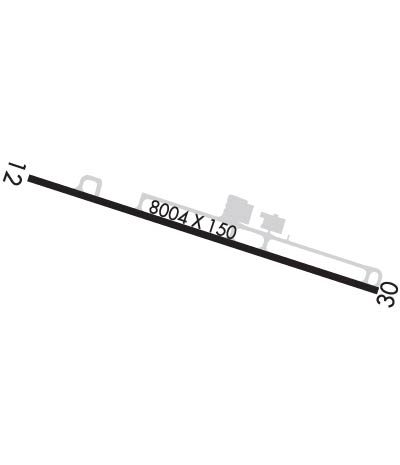
| Lat: N 1800.5 Long: W 06633.9 Elev: 28 Var: +11 Longest Runway: 8004 | ||
| Clr Del: 121.9 CTAF: 122.7 | ||
| ||||||||||||||||||||||||||||||||||||||||||||
| ||||||||||||||||||||||||||||||||||||||||||||
| Rwy | Rwy | |||||||
| 8004x150 | 6122' | 8004x150 | 7756' | |||||
| Runway ID | Single Wheel | Double Wheel | Double Tandem Wheel | Dual Double Wheel |
| 12/30 | N/A | N/A | N/A | N/A |
| These numbers are Advisory and are not limits. The Airport Manager should have more accurate Weight Limits | ||||
 Airport Diagram might not be current. | |
| Facility Name: | MERCEDITA |
| City Name: | PONCE |
| County: | --PUERTO RICO |
| State abbrev: | PR |
| State Name: | PUERTO RICO |
| Ownership: | PUBLICLY OWNED |
| Use: | OPEN TO THE PUBLIC |
| Owner's Name: | PUERTO RICO PORT AUTH |
| Address: | PO BOX 2829 |
| SAN JUAN, PR 00936 | |
| Owner's Phone: | 787-729-8715 |
| Manager's Name: | WILLIAM FEBLES |
| Address: | P.O. BOX 670 |
| MERCEDITA, PR 00715 | |
| Phone: | 787-729-8715; EXT 5100 OR 5101 |
| FAA Region: | SOUTHERN |
| FAA Field Office: | ATL |
| Date | Sunrise | Sunset |
|---|---|---|
| 04/29/25 Tuesday | 6:01 | 18:47 |
| 04/30/25 Wednesday | 6:00 | 18:47 |
| 05/01/25 Thursday | 6:00 | 18:47 |
| 05/02/25 Friday | 5:59 | 18:48 |
| 05/03/25 Saturday | 5:59 | 18:48 |
| 05/04/25 Sunday | 5:58 | 18:48 |
| 05/05/25 Monday | 5:58 | 18:49 |
| 05/06/25 Tuesday | 5:57 | 18:49 |
| 05/07/25 Wednesday | 5:57 | 18:49 |
| 05/08/25 Thursday | 5:56 | 18:50 |
| 05/09/25 Friday | 5:56 | 18:50 |
| 05/10/25 Saturday | 5:55 | 18:50 |
| 05/11/25 Sunday | 5:55 | 18:51 |
| 05/12/25 Monday | 5:55 | 18:51 |
| Airport Attendance Schedule | CONTINUOUS |
| Airport Status | OPERATIONAL (This Status can change at any time - please check NOTAMS) |
| Airport Lighting Schedule | HIRL RWY 12/30 PRESET MED INTST DUSK-2200; TO INCR INTST & ACTVT HIRL RWY 12/30 AND REIL RWY 12 AFTER 2200 - UNICOM 122.70. PAPI RWY 30 OPER CONT. |
| Airport Storage Available | Tie Downs, Hanger |
| Extra Services Available | Crop Dusting, Cargo Handling, Charter, Flight Instruction, Aircraft Rental, Glider Towing |
| Wind Indicator | YES - (lighted) |
| Control Tower | NO |
| CTAF Frequency | 122.700 |
| Unicom Frequency | 122.700 |
| Rotating Beacon Color | WG |
| Segmented Circle | YES |
| Landing Fee | YES; FEE FOR OTHER THAN HOME BASED ACFT. |
| Airport Inspected | FEDERAL - performed by FAA AIRPORTS FIELD PERSONNEL |
| Inspection Date | 05/23/2024 |
| Type of Fuel Available | Grade 100LL, JET A (freeze point -40C) |
| Airframe Repair Service | MINOR |
| Power Plant Repair Service | MINOR |
| Latitude | N1800.5 |
| Longitude | W06633.9 (ESTIMATED) |
| Arpt Elevation | 28ft (SURVEYED) |
| Magnetic Variation | 11W |
| 3 miles E | of PONCE |
| Traffic Pattern Altitude | |
| Sectional Chart | PUERTO RICO-VIRGIN ISLANDS |
| Operations (Reported) | Yearly | Avg. Daily |
|---|---|---|
| General Aviation Transient | 0 | 0 |
| General Aviation Local | 0 | 0 |
| Air Taxi | 0 | 0 |
| Commerical | 0 | 0 |
| Commuter | 0 | 0 |
| Military | 0 | 0 |
| Aircraft based on Field | |
|---|---|
| General Aviation Singles | 0 |
| General Aviation Multi | 0 |
| Jet Aircraft | 0 |
| General Aviation Helicopters | 0 |
| Military Aircraft | 0 |
| Gliders | 0 |
| Ultralights | 0 |
| FSS on field | NO |
| FSS tie-in | SAN JUAN |
| FSS Phone | 1-800-WX-BRIEF |
| Who issues Notams | TJPS |
| Notam D service at airport | YES |
| ARTCC Name | SAN JUAN |
| Airport Certification | AIRPORT RECEIVING SCHEDULED AIR CARRIER SERVICE FROM CARRIERS CERTIFICATED BY THE CIVIL AERONAUTICS BOARD; PPR 24 HRS FOR INDEX C & ABOVE UNSKED ACR OPNS WITH MORE THAN 30 PSGR SEATS CALL AMGR 787-842-6292. |
| Aircraft Rescue & Firefighting Index | AIRPORT HAS A CERTIFICATE UNDER CFR PART 139 |
| Airport of Entry | No |
| Custom Landing Rights | YES |
| Joint Civil/Military | No |
| Military Landing rights | YES |
| NATIONAL PLAN OF INTEGRATED AIRPORT SYSTEMS (NPIAS) |
| GRANT AGREEMENTS UNDER FAAP/ADAP/AIP |
| ASSURANCES PURSUANT TO TITLE VI, CIVIL RIGHTS ACT OF 1964 |
| CUSTOMS AVAILABLE 1200Z TO 2100Z MON-FRI. |
| FOR CD IF FREQ ARE OTS CTC SAN JUAN CERAP AT 787-253-8664/8665. |
| RWY 12/3 0 RWY 30, LAST 1100 FT NOT GROOVED. |
| RWY 12/3 0 PCR VALUE: 400/F/C/X/T |
Airport Communications & Frequencies:
| |||||||||
| Runway: 12 | Runway: 30 | ||
| Mag heading: | 119° | Mag heading: | 299° |
| Rwy Slope: | -.01% Down | Rwy Slope: | .01% Up |
| Approach: | Approach: | ||
| Pattern: | Right Traffic | Pattern: | Left Traffic |
| Markings: | NONPRECISION INSTRUMENT | Markings: | NONPRECISION INSTRUMENT |
| Marking Condition: | GOOD | Marking Condition: | GOOD |
| Arresting Dev: | Arresting Dev: | ||
| Lat & Long: | N1800.7 W06634.5 | Lat. & Long.: | N1800.3 W06633.2 |
| Elev: | 28.4 ft. MSL | Elev: | 27.2 ft. MSL |
| TCH: | TCH: | 53 ft. AGL | |
| Visual Glide Path: | Visual Glide Path: | 3.00 degrees | |
| Displaced Threshold: | 1882 feet | Displaced Threshold: | 248 feet |
| Touchdown Zone: | YES | Touchdown Zone: | YES |
| Touchdown Elev.: | 27.3 feet | Touchdown Elev.: | 25.1 feet |
| Visual Glide Slope: | Visual Glide Slope: | 4-Light PAPI on RIGHT side of Runway | |
| RVR Equipment: | RVR Equipment: | ||
| RVV Equipment: | NO | RVV Equipment: | NO |
| Approach Lights: | Approach Lights: | ||
| REIL: | YES | REIL: | YES |
| Centerline Lights: | NO | Centerline Lights: | NO |
| Touchdown lights: | NO | Touchdown lights: | NO |
| Runway Category: | Runway with a Non-precision Approach having visibility minimums greater than 3/4 mile | Runway Category: | Runway with a Non-precision Approach having visibility minimums greater than 3/4 mile |
| Declared Distances: | TORA:8004' TODA:8004' ASDA:7357' LDA:5488' | Declared Distances: | TORA:8004' TODA:8004' ASDA:7004' LDA:6757' |
| Obstructions: | PLINE | Obstructions: | TREES |
| Marked: | LIGHTED | Marked: | NOT Marked/Lighted |
| Clearance slope: | 13:1; APCH RATIO 16:1 TO DSPLCD THR. | Clearance slope: | 33:1 |
| Obstruction height: | 295 feet AGL | Obstruction height: | 41 feet AGL |
| Dist. from runway: | 4155 feet | Dist. from runway: | 1570 feet |
| Centerline offset: | 800 left of centerline | Centerline offset: | 75 feet left of centerline |
| Comments: | Comments: |
Thanks for using FltPlan.com
all rights reserved © 1999-2025 by Flight Plan LLC