
| LAKE CUMBERLAND RGNL SOMERSET KY |
| |
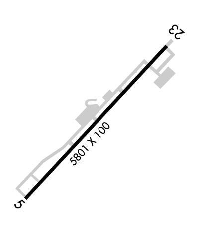
| Lat: N 3703.2 Long: W 08436.9 Elev: 927 Var: +05 Longest Runway: 5801 | ||
| AWOS: 120.05 CTAF: 122.8 | ||
| ||||||||||||||||||||||||||||||||||||||||||||
| ||||||||||||||||||||||||||||||||||||||||||||
| ||||||||||||||||||||||||||||||||||||||||||||
| Rwy | Rwy | |||||||
| 5801x100 | 5287' | 109.30 - 048° | 5801x100 | 5501' | ||||
| Runway ID | Single Wheel | Double Wheel | Double Tandem Wheel | Dual Double Wheel |
| 05/23 | 48,500 | 68,000 | 125,000 | N/A |
| These numbers are Advisory and are not limits. The Airport Manager should have more accurate Weight Limits | ||||
 Airport Diagram might not be current. | |
| Facility Name: | LAKE CUMBERLAND RGNL |
| City Name: | SOMERSET |
| County: | PULASKI |
| State abbrev: | KY |
| State Name: | KENTUCKY |
| Ownership: | PUBLICLY OWNED |
| Use: | OPEN TO THE PUBLIC |
| Owner's Name: | SOMERSET-PULASKI COUNTY |
| Address: | 500 W.O. NEWELL DRIVE |
| SOMERSET, KY 42501 | |
| Owner's Phone: | 606-679-7908 |
| Manager's Name: | KELLIE BAKER |
| Address: | 500 W.O. NEWELL DRIVE |
| SOMERSET, KY 42501 | |
| Phone: | 606-679-7908 |
| FAA Region: | SOUTHERN |
| FAA Field Office: | MEM |

| Date | Sunrise | Sunset |
|---|---|---|
| 12/15/25 Monday | 7:44 | 17:23 |
| 12/16/25 Tuesday | 7:45 | 17:23 |
| 12/17/25 Wednesday | 7:46 | 17:23 |
| 12/18/25 Thursday | 7:46 | 17:24 |
| 12/19/25 Friday | 7:47 | 17:24 |
| 12/20/25 Saturday | 7:48 | 17:25 |
| 12/21/25 Sunday | 7:48 | 17:25 |
| 12/22/25 Monday | 7:49 | 17:26 |
| 12/23/25 Tuesday | 7:49 | 17:26 |
| 12/24/25 Wednesday | 7:49 | 17:27 |
| 12/25/25 Thursday | 7:50 | 17:27 |
| 12/26/25 Friday | 7:50 | 17:28 |
| 12/27/25 Saturday | 7:51 | 17:29 |
| 12/28/25 Sunday | 7:51 | 17:29 |
| Airport Attendance Schedule | MON-FRI 0700-1800, SAT-SUN 0800-1800 |
| Airport Status | OPERATIONAL (This Status can change at any time - please check NOTAMS) |
| Airport Lighting Schedule | ACTVT REIL RWY 05 & 23; PAPI RWY 05 & 23; MIRL RWY 05/23 - CTAF. |
| Airport Storage Available | Tie Downs, Hanger |
| Extra Services Available | Air Ambulance |
| Wind Indicator | YES - (lighted) |
| Control Tower | NO |
| CTAF Frequency | 122.800 |
| Unicom Frequency | 122.800 |
| Rotating Beacon Color | WG |
| Segmented Circle | YES |
| Landing Fee | NO |
| Airport Inspected | STATE - performed by STATE AERONAUTICAL PERSONNEL |
| Inspection Date | 04/13/2021 |
| Type of Fuel Available | Grade 100LL, JET A |
| Airframe Repair Service | MINOR |
| Power Plant Repair Service | MINOR |
| Latitude | N3703.2 |
| Longitude | W08436.9 (ESTIMATED) |
| Arpt Elevation | 927ft (SURVEYED) |
| Magnetic Variation | 05W |
| 3 miles S | of SOMERSET |
| Traffic Pattern Altitude | |
| Sectional Chart | CINCINNATI |
| Operations (Reported) | Yearly | Avg. Daily |
|---|---|---|
| General Aviation Transient | 0 | 0 |
| General Aviation Local | 0 | 0 |
| Air Taxi | 0 | 0 |
| Commerical | 0 | 0 |
| Commuter | 0 | 0 |
| Military | 0 | 0 |
| Aircraft based on Field | |
|---|---|
| General Aviation Singles | 0 |
| General Aviation Multi | 0 |
| Jet Aircraft | 0 |
| General Aviation Helicopters | 0 |
| Military Aircraft | 0 |
| Gliders | 0 |
| Ultralights | 0 |
| FSS on field | NO |
| FSS tie-in | LOUISVILLE |
| FSS Phone | 1-800-WX-BRIEF |
| Who issues Notams | SME |
| Notam D service at airport | YES |
| ARTCC Name | INDIANAPOLIS |
| Airport Certification | INDEX A ARFF EQUIP AVBL ON REQ. CLSD TO UNSKED ACR OPS MORE THAN 30 PAX SEATS. |
| Aircraft Rescue & Firefighting Index | None |
| Airport of Entry | No |
| Custom Landing Rights | No |
| Joint Civil/Military | No |
| Military Landing rights | YES |
| NATIONAL PLAN OF INTEGRATED AIRPORT SYSTEMS (NPIAS) |
| GRANT AGREEMENTS UNDER FAAP/ADAP/AIP |
| ASSURANCES PURSUANT TO TITLE VI, CIVIL RIGHTS ACT OF 1964 |
| FOR CD CTC INDIANAPOLIS ARTCC AT 317-247-2411. |
Airport Communications & Frequencies:
| |||||||||
| Runway: 05 | Runway: 23 | ||
| Mag heading: | 48° | Mag heading: | 228° |
| Rwy Slope: | .18% Up | Rwy Slope: | -.18% Down |
| Approach: | ILS/DME | Approach: | |
| Pattern: | Left Traffic | Pattern: | Left Traffic |
| Markings: | PRECISION INSTRUMENT | Markings: | NONPRECISION INSTRUMENT |
| Marking Condition: | GOOD | Marking Condition: | GOOD |
| Arresting Dev: | Arresting Dev: | ||
| Lat & Long: | N3702.9 W08437.3 | Lat. & Long.: | N3703.6 W08436.5 |
| Elev: | 910.8 ft. MSL | Elev: | 921.0 ft. MSL |
| TCH: | 60 ft. AGL | TCH: | 54 ft. AGL |
| Visual Glide Path: | 3.00 degrees | Visual Glide Path: | 3.00 degrees |
| Displaced Threshold: | 514 feet | Displaced Threshold: | 300 feet |
| Touchdown Zone: | YES | Touchdown Zone: | YES |
| Touchdown Elev.: | 927.3 feet | Touchdown Elev.: | 927.3 feet |
| Visual Glide Slope: | 2-Light PAPI on RIGHT side of Runway | Visual Glide Slope: | 2-Light PAPI on LEFT side of Runway |
| RVR Equipment: | RVR Equipment: | ||
| RVV Equipment: | NO | RVV Equipment: | NO |
| Approach Lights: | Approach Lights: | ||
| REIL: | YES | REIL: | YES |
| Centerline Lights: | NO | Centerline Lights: | NO |
| Touchdown lights: | NO | Touchdown lights: | NO |
| Runway Category: | Precision Instrument Runway | Runway Category: | Runway with a Non-precision Approach having visibility minimums greater than 3/4 mile |
| Declared Distances: | TORA:5800' TODA:5800' ASDA:5800' LDA:5287' | Declared Distances: | TORA:5800' TODA:5800' ASDA:5800' LDA:5500' |
| Obstructions: | TREE | Obstructions: | TREES |
| Marked: | NOT Marked/Lighted | Marked: | NOT Marked/Lighted |
| Clearance slope: | 8:1; APCH RATIO 14:1 TO DTHR. | Clearance slope: | 17:1; APCH RATIO 19:1 TO DTHR. |
| Obstruction height: | 103 feet AGL | Obstruction height: | 338 feet AGL |
| Dist. from runway: | 1028 feet | Dist. from runway: | 6170 feet |
| Centerline offset: | 882 left of centerline | Centerline offset: | 919 feet left of centerline |
| Comments: | Comments: |
Thanks for using FltPlan.com
all rights reserved © 1999-2025 by Flight Plan LLC