
| NORTH CENTRAL STATE PAWTUCKET RI |
| |
| Lat: N 4155.2 Long: W 07129.5 Elev: 441 Var: +15 Longest Runway: 5000 | ||
| Clr Del: 124.35 AWOS: 120.77 CTAF: 123.07 | ||
| ||||||||||||||||||||||||||||||||||||||||||||
| ||||||||||||||||||||||||||||||||||||||||||||
| ||||||||||||||||||||||||||||||||||||||||||||
| Rwy | Rwy | |||||||
| 5000x100 | 5000' | 111.90 - 047° | 5000x100 | 5000' | ||||
| 3211x75 | 3211' | 3211x75 | 3211' | |||||
| Runway ID | Single Wheel | Double Wheel | Double Tandem Wheel | Dual Double Wheel |
| 05/23 | 30,000 | 60,000 | N/A | N/A |
| 15/33 | 12,500 | N/A | N/A | N/A |
| These numbers are Advisory and are not limits. The Airport Manager should have more accurate Weight Limits | ||||
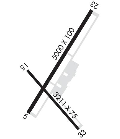 Airport Diagram might not be current. | |
| Facility Name: | NORTH CENTRAL STATE |
| City Name: | PAWTUCKET |
| County: | PROVIDENCE |
| State abbrev: | RI |
| State Name: | RHODE ISLAND |
| Ownership: | PUBLICLY OWNED |
| Use: | OPEN TO THE PUBLIC |
| Owner's Name: | STATE OF RHODE ISLAND |
| Address: | RHODE ISLAND AIRPORT CORPORATION |
| WARWICK, RI 02886 | |
| Owner's Phone: | (401) 691-2000 |
| Manager's Name: | IFTIKHAR AHMAD |
| Address: | RHODE ISLAND AIRPORT CORP, 2000 POST RD |
| WARWICK, RI 02886 | |
| Phone: | (401) 691-2000 |
| FAA Region: | NEW ENGLAND |
| FAA Field Office: | NONE |
| Date | Sunrise | Sunset |
|---|---|---|
| 09/24/21 Friday | 6:35 | 18:40 |
| 09/25/21 Saturday | 6:36 | 18:38 |
| 09/26/21 Sunday | 6:37 | 18:37 |
| 09/27/21 Monday | 6:38 | 18:35 |
| 09/28/21 Tuesday | 6:39 | 18:33 |
| 09/29/21 Wednesday | 6:40 | 18:32 |
| 09/30/21 Thursday | 6:41 | 18:30 |
| 10/01/21 Friday | 6:43 | 18:28 |
| 10/02/21 Saturday | 6:44 | 18:26 |
| 10/03/21 Sunday | 6:45 | 18:25 |
| 10/04/21 Monday | 6:46 | 18:23 |
| 10/05/21 Tuesday | 6:47 | 18:21 |
| 10/06/21 Wednesday | 6:48 | 18:20 |
| 10/07/21 Thursday | 6:49 | 18:18 |
| Airport Attendance Schedule | UNATNDD TUE-FRI 1530-0700, UNATNDD SAT-SUN |
| Airport Status | OPERATIONAL (This Status can change at any time - please check NOTAMS) |
| Airport Lighting Schedule | ACTVT MALS RWY 05; REIL RWY 23, 15 & 33; PAPI RWY 15 & 23; HIRL RWY 05/23; MIRL RWY 15/33; TWY LGTS - CTAF. |
| Airport Storage Available | Tie Downs, Hanger |
| Extra Services Available | Charter, Flight Instruction, Parachute Jumping, Aircraft Rental, Aircraft Sales |
| Wind Indicator | YES - (lighted) |
| Control Tower | NO |
| CTAF Frequency | 123.075 |
| Unicom Frequency | 123.075 |
| Rotating Beacon Color | CLEAR-GREEN (Light Land Airport) |
| Segmented Circle | YES |
| Landing Fee | YES; LDG FEE FOR COML ACFT & NON-RHODE ISLAND REGISTERED ACFT. |
| Airport Inspected | STATE - performed by the OWNER |
| Inspection Date | 08/07/2017 |
| Type of Fuel Available | Grade 100LL, JET A (freeze point -40C), JET A |
| Airframe Repair Service | MAJOR |
| Power Plant Repair Service | MAJOR |
| Latitude | N4155.2 |
| Longitude | W07129.5 (ESTIMATED) |
| Arpt Elevation | 440ft (SURVEYED) |
| Magnetic Variation | 15W |
| 3 miles E | of PAWTUCKET |
| Traffic Pattern Altitude | |
| Sectional Chart | NEW YORK |
| Operations (Reported) | Yearly | Avg. Daily |
|---|---|---|
| General Aviation Transient | 4044 | 11 |
| General Aviation Local | 9994 | 27 |
| Air Taxi | 670 | 2 |
| Commerical | 0 | 0 |
| Commuter | 0 | 0 |
| Military | 136 | 0 |
| Aircraft based on Field | |
|---|---|
| General Aviation Singles | 32 |
| General Aviation Multi | 1 |
| Jet Aircraft | 0 |
| General Aviation Helicopters | 1 |
| Military Aircraft | 0 |
| Gliders | 0 |
| Ultralights | 0 |
| FSS on field | NO |
| FSS tie-in | BRIDGEPORT |
| FSS Phone | 1-800-WX-BRIEF |
| Who issues Notams | SFZ |
| Notam D service at airport | YES |
| ARTCC Name | BOSTON |
| Airport Certification | |
| Aircraft Rescue & Firefighting Index | None |
| Airport of Entry | No |
| Custom Landing Rights | YES |
| Joint Civil/Military | No |
| Military Landing rights | YES |
| NATIONAL PLAN OF INTEGRATED AIRPORT SYSTEMS (NPIAS) |
| GRANT AGREEMENTS UNDER FAAP/ADAP/AIP |
| ASSURANCES PURSUANT TO TITLE VI, CIVIL RIGHTS ACT OF 1964 |
| SEASONAL GLDR OPNS INVOF ARPT SR-SS. |
| RWY CONDS MAY NOT BE MNT OR RPRTD WHEN AP IS UNATNDD. CTC RI AP CORPORATION OPS AT 401-691-2265. |
| FOR CD CTC WHEN APCH CLSD CTC BOSTON ARTCC AT 603-879-6859. |
| AP WILDLIFE HAZ DEER ACT INCREASED HN. |
| NMRS UNLGTD OBSTNS UP TO 150 FT AGL SRNDG AIRFIELD. |
| LGTD 250 FT MSL TWR 3-2/5 MI SE. |
| DEER & BIRDS ON & INVOF ARPT. |
| OVNGT PRKG FEE. |
| +50 FT DROPOFF 250 FT FM RWY 05 END, +40 FT DROPOFF 250 FT FM RWY 23 END. |
| SEASONAL SKYDIVING NE SIDE OF AIRFIELD. |
| NOISE ABATEMENT PROCS IN EFCT, CTC AMGR. |
Airport Communications & Frequencies:
| |||||||||||||||||||
| Runway: 05 | Runway: 23 | ||
| Mag heading: | 47° | Mag heading: | 227° |
| Rwy Slope: | .01% Up | Rwy Slope: | -.01% Down |
| Approach: | LOC/DME | Approach: | |
| Pattern: | Left Traffic | Pattern: | Left Traffic |
| Markings: | NONPRECISION INSTRUMENT | Markings: | NONPRECISION INSTRUMENT |
| Marking Condition: | GOOD | Marking Condition: | GOOD |
| Arresting Dev: | Arresting Dev: | ||
| Lat & Long: | N4155.0 W07129.7 | Lat. & Long.: | N4155.7 W07129.2 |
| Elev: | 418.7 ft. MSL | Elev: | 419.0 ft. MSL |
| TCH: | 52 ft. AGL | TCH: | 35 ft. AGL |
| Visual Glide Path: | 3.00 degrees | Visual Glide Path: | 3.00 degrees |
| Displaced Threshold: | No | Displaced Threshold: | No |
| Touchdown Zone: | YES | Touchdown Zone: | YES |
| Touchdown Elev.: | 428.7 feet | Touchdown Elev.: | 428.7 feet |
| Visual Glide Slope: | 4-Light PAPI on RIGHT side of Runway | Visual Glide Slope: | 4-Light PAPI on LEFT side of Runway |
| RVR Equipment: | RVR Equipment: | ||
| RVV Equipment: | NO | RVV Equipment: | NO |
| Approach Lights: | MALS - 1,400 foot medium intensity approach lighting system | Approach Lights: | |
| REIL: | NO | REIL: | YES |
| Centerline Lights: | NO | Centerline Lights: | NO |
| Touchdown lights: | NO | Touchdown lights: | NO |
| Runway Category: | D | Runway Category: | D |
| Declared Distances: | Declared Distances: | ||
| Obstructions: | TREES | Obstructions: | TREES |
| Marked: | NOT Marked/Lighted | Marked: | NOT Marked/Lighted |
| Clearance slope: | 38:1 | Clearance slope: | 50:1 |
| Obstruction height: | 45 feet AGL | Obstruction height: | 14 feet AGL |
| Dist. from runway: | 1900 feet | Dist. from runway: | 900 feet |
| Centerline offset: | 150 left of centerline | Centerline offset: | 150 feet right of centerline |
| Comments: | RWY 05, + 10 FT TREES 150 FT FM THR, 180 FT LEFT; +10 FT TREES 120 FM THR, 180 FT RIGHT. | Comments: | RWY 23, +15 FT TREES 170 FT FM THR, 90 FT RIGHT; +10 FT TREES 120 FT FM THR, 150 FT LEFT. |
| Runway: 15 | Runway: 33 | ||
| Mag heading: | 155° | Mag heading: | 335° |
| Rwy Slope: | .46% Up | Rwy Slope: | -.46% Down |
| Approach: | Approach: | ||
| Pattern: | Left Traffic | Pattern: | Left Traffic |
| Markings: | BASIC | Markings: | BASIC |
| Marking Condition: | GOOD | Marking Condition: | GOOD |
| Arresting Dev: | Arresting Dev: | ||
| Lat & Long: | N4155.3 W07129.8 | Lat. & Long.: | N4154.9 W07129.3 |
| Elev: | 425.5 ft. MSL | Elev: | 440.2 ft. MSL |
| TCH: | 35 ft. AGL | TCH: | |
| Visual Glide Path: | 3.50 degrees | Visual Glide Path: | |
| Displaced Threshold: | No | Displaced Threshold: | No |
| Touchdown Zone: | YES | Touchdown Zone: | YES |
| Touchdown Elev.: | 439.2 feet | Touchdown Elev.: | 440.5 feet |
| Visual Glide Slope: | 4-Light PAPI on RIGHT side of Runway | Visual Glide Slope: | |
| RVR Equipment: | RVR Equipment: | ||
| RVV Equipment: | NO | RVV Equipment: | NO |
| Approach Lights: | Approach Lights: | ||
| REIL: | YES | REIL: | YES |
| Centerline Lights: | NO | Centerline Lights: | NO |
| Touchdown lights: | NO | Touchdown lights: | NO |
| Runway Category: | Runway with a Visual Approach | Runway Category: | Runway with a Visual Approach |
| Declared Distances: | Declared Distances: | ||
| Obstructions: | TREES | Obstructions: | TREES |
| Marked: | NOT Marked/Lighted | Marked: | NOT Marked/Lighted |
| Clearance slope: | 25:1 | Clearance slope: | 18:1 |
| Obstruction height: | 47 feet AGL | Obstruction height: | 55 feet AGL |
| Dist. from runway: | 1400 feet | Dist. from runway: | 1200 feet |
| Centerline offset: | 150 left of centerline | Centerline offset: | 50 feet left of centerline |
| Comments: | Comments: |
Thanks for using FltPlan.com
all rights reserved © 1999-2021 by Flight Plan LLC
