
| WATFORD CITY MUNI WATFORD CITY ND |
| |
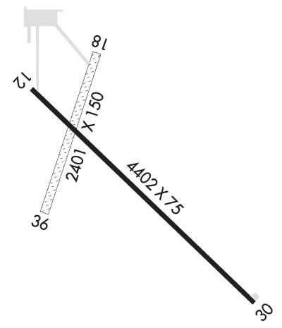
| Lat: N 4747.8 Long: W 10315.3 Elev: 2111 Var: -09 Longest Runway: 4401 | ||
| AWOS: 118.22 CTAF: 122.8 | ||
| ||||||
| ||||||
|
| Rwy | Rwy | |||||||
| 4401x75 | 4401' | 4401x75 | 4401' | |||||
| 2401x132 | 2401' | 2401x132 | 2401' | |||||
| Runway ID | Single Wheel | Double Wheel | Double Tandem Wheel | Dual Double Wheel |
| 12/30 | 12,500 | N/A | N/A | N/A |
| 18/36 | N/A | N/A | N/A | N/A |
| These numbers are Advisory and are not limits. The Airport Manager should have more accurate Weight Limits | ||||
 Airport Diagram might not be current. | |
| Facility Name: | WATFORD CITY MUNI |
| City Name: | WATFORD CITY |
| County: | MC KENZIE |
| State abbrev: | ND |
| State Name: | NORTH DAKOTA |
| Ownership: | PUBLICLY OWNED |
| Use: | OPEN TO THE PUBLIC |
| Owner's Name: | WATFORD CITY ARPT AUTH |
| Address: | BOX 730 |
| WATFORD CITY, ND 58854 | |
| Owner's Phone: | (701) 570-2646 |
| Manager's Name: | LUKE TAYLOR |
| Address: | BOX 730 |
| WATFORD CITY, ND 58854 | |
| Phone: | (701) 570-2646; ADDNL CONTACT - FBO PHONE 701-300-3045. |
| FAA Region: | GREAT LAKES |
| FAA Field Office: | DMA |
| Date | Sunrise | Sunset |
|---|---|---|
| 09/24/21 Friday | 7:42 | 19:47 |
| 09/25/21 Saturday | 7:44 | 19:45 |
| 09/26/21 Sunday | 7:45 | 19:43 |
| 09/27/21 Monday | 7:46 | 19:41 |
| 09/28/21 Tuesday | 7:48 | 19:39 |
| 09/29/21 Wednesday | 7:49 | 19:37 |
| 09/30/21 Thursday | 7:50 | 19:35 |
| 10/01/21 Friday | 7:52 | 19:33 |
| 10/02/21 Saturday | 7:53 | 19:31 |
| 10/03/21 Sunday | 7:55 | 19:29 |
| 10/04/21 Monday | 7:56 | 19:27 |
| 10/05/21 Tuesday | 7:57 | 19:25 |
| 10/06/21 Wednesday | 7:59 | 19:23 |
| 10/07/21 Thursday | 8:00 | 19:21 |
| Airport Attendance Schedule | MON-FRI 0800-1700; ON CALL WEEKENDS AND NIGHTS |
| Airport Status | OPERATIONAL (This Status can change at any time - please check NOTAMS) |
| Airport Lighting Schedule | MIRL RY 12/30 PRESET ON LOW INTST DUSK-2200; TO INCR INTST - CTAF. AFT 2200 ACTVT MIRL RY 12/30 & PAPI RYS 12 & 30 - CTAF.; DUSK-2200. AFT 2200 ACTVT ROTG BCN - CTAF. |
| Airport Storage Available | Tie Downs, Hanger |
| Extra Services Available | Crop Dusting, Flight Instruction, Aircraft Rental |
| Wind Indicator | YES - (lighted) |
| Control Tower | NO |
| CTAF Frequency | 122.800 |
| Unicom Frequency | 122.800; UNICOM LCTD AT SHERIFF'S OFFICE. |
| Rotating Beacon Color | CLEAR-GREEN (Light Land Airport) |
| Segmented Circle | YES |
| Landing Fee | NO |
| Airport Inspected | STATE - performed by STATE AERONAUTICAL PERSONNEL |
| Inspection Date | 10/14/2016 |
| Type of Fuel Available | Grade 100LL, JET A (freeze point -40C); -A FULL SVC FUEL AVBL 800-1700 M-F AND SELF SVC WITH CREDIT CARD ALL OTHER HOURS. |
| Airframe Repair Service | MINOR |
| Power Plant Repair Service | MINOR |
| Latitude | N4747.8 |
| Longitude | W10315.3 (ESTIMATED) |
| Arpt Elevation | 2111ft (SURVEYED) |
| Magnetic Variation | 09E |
| 1 miles ESE | of WATFORD CITY |
| Traffic Pattern Altitude | |
| Sectional Chart | BILLINGS |
| Operations (Reported) | Yearly | Avg. Daily |
|---|---|---|
| General Aviation Transient | 3000 | 8 |
| General Aviation Local | 3500 | 10 |
| Air Taxi | 750 | 2 |
| Commerical | 0 | 0 |
| Commuter | 0 | 0 |
| Military | 50 | 0 |
| Aircraft based on Field | |
|---|---|
| General Aviation Singles | 35 |
| General Aviation Multi | 1 |
| Jet Aircraft | 2 |
| General Aviation Helicopters | 0 |
| Military Aircraft | 0 |
| Gliders | 0 |
| Ultralights | 0 |
| FSS on field | NO |
| FSS tie-in | GRAND FORKS |
| FSS Phone | 1-800-WX-BRIEF |
| Who issues Notams | GFK |
| Notam D service at airport | YES |
| ARTCC Name | SALT LAKE CITY |
| Airport Certification | |
| Aircraft Rescue & Firefighting Index | None |
| Airport of Entry | No |
| Custom Landing Rights | No |
| Joint Civil/Military | No |
| Military Landing rights | YES |
| NATIONAL PLAN OF INTEGRATED AIRPORT SYSTEMS (NPIAS) |
| GRANT AGREEMENTS UNDER FAAP/ADAP/AIP |
| ASSURANCES PURSUANT TO TITLE VI, CIVIL RIGHTS ACT OF 1964 |
| AFT WINTER STORMS CFM ARPT CONDS WITH AMGR; CALL (701) 300-3045 OR 701-570-2646. |
| DEER & ANTELOPE ON OR INVOF ARPT. |
| FOR CD CTC SALT LAKE ARTCC AT 801-320-2568. |
| RWY 18/3 6 GRASS RY 18/36 CLSD WINTER MONTHS (OCT THRU APR) DUE TO LACK OF SNOW REMOVAL. |
Airport Communications & Frequencies:
| |||||||||
| Runway: 12 | Runway: 30 | ||
| Mag heading: | 126° | Mag heading: | 306° |
| Rwy Slope: | 1.18% Up | Rwy Slope: | -1.18% Down |
| Approach: | Approach: | ||
| Pattern: | Left Traffic | Pattern: | Left Traffic |
| Markings: | NONPRECISION INSTRUMENT | Markings: | NONPRECISION INSTRUMENT |
| Marking Condition: | FAIR | Marking Condition: | FAIR |
| Arresting Dev: | Arresting Dev: | ||
| Lat & Long: | N4748.0 W10315.6 | Lat. & Long.: | N4747.5 W10314.8 |
| Elev: | 2059.1 ft. MSL | Elev: | 2111.2 ft. MSL |
| TCH: | 27 ft. AGL | TCH: | 29 ft. AGL |
| Visual Glide Path: | 3.00 degrees | Visual Glide Path: | 3.00 degrees |
| Displaced Threshold: | No | Displaced Threshold: | No |
| Touchdown Zone: | YES | Touchdown Zone: | YES |
| Touchdown Elev.: | 2090.4 feet | Touchdown Elev.: | 2111.2 feet |
| Visual Glide Slope: | 2-Light PAPI on LEFT side of Runway | Visual Glide Slope: | 2-Light PAPI on LEFT side of Runway |
| RVR Equipment: | RVR Equipment: | ||
| RVV Equipment: | NO | RVV Equipment: | NO |
| Approach Lights: | Approach Lights: | ||
| REIL: | NO | REIL: | NO |
| Centerline Lights: | NO | Centerline Lights: | NO |
| Touchdown lights: | NO | Touchdown lights: | NO |
| Runway Category: | Runway with a Non-precision Approach | Runway Category: | Runway with a Non-precision Approach |
| Declared Distances: | Declared Distances: | ||
| Obstructions: | ROAD; ALSO +306 FT TWR 6600 FT FROM THR 4000 FT RIGHT OF CNTRLN EXTDD. | Obstructions: | HILL |
| Marked: | NOT Marked/Lighted | Marked: | LIGHTED; +167'HILL LGTD W/OBS LGTS. |
| Clearance slope: | 16:1 | Clearance slope: | 21:1 |
| Obstruction height: | 17 feet AGL | Obstruction height: | 167 feet AGL |
| Dist. from runway: | 475 feet | Dist. from runway: | 3800 feet |
| Centerline offset: | 150 right of centerline | Centerline offset: | 240 feet left of centerline |
| Comments: | Comments: |
| Runway: 18 | Runway: 36 | ||
| Mag heading: | 189° | Mag heading: | 9° |
| Rwy Slope: | .24% Up | Rwy Slope: | -.24% Down |
| Approach: | Approach: | ||
| Pattern: | Left Traffic | Pattern: | Left Traffic |
| Markings: | Markings: | ||
| Marking Condition: | 18/36 DAYLIGHT MRKERS ON ENDS/EDGES. | Marking Condition: | |
| Arresting Dev: | Arresting Dev: | ||
| Lat & Long: | N4748.1 W10315.4 | Lat. & Long.: | N4747.7 W10315.6 |
| Elev: | 2057.2 ft. MSL | Elev: | 2062.9 ft. MSL |
| TCH: | TCH: | ||
| Visual Glide Path: | Visual Glide Path: | ||
| Displaced Threshold: | No | Displaced Threshold: | No |
| Touchdown Zone: | YES | Touchdown Zone: | YES |
| Touchdown Elev.: | 2063.0 feet | Touchdown Elev.: | 2063.0 feet |
| Visual Glide Slope: | Visual Glide Slope: | ||
| RVR Equipment: | RVR Equipment: | ||
| RVV Equipment: | NO | RVV Equipment: | NO |
| Approach Lights: | Approach Lights: | ||
| REIL: | NO | REIL: | NO |
| Centerline Lights: | NO | Centerline Lights: | NO |
| Touchdown lights: | NO | Touchdown lights: | NO |
| Runway Category: | Runway with a Visual Approach | Runway Category: | Runway with a Visual Approach |
| Declared Distances: | Declared Distances: | ||
| Obstructions: | Obstructions: | PLINE | |
| Marked: | Marked: | NOT Marked/Lighted | |
| Clearance slope: | 50:1 | Clearance slope: | 36:1 |
| Obstruction height: | Obstruction height: | 50 feet AGL | |
| Dist. from runway: | Dist. from runway: | 1800 feet | |
| Centerline offset: | Centerline offset: | ||
| Comments: | Comments: |
Thanks for using FltPlan.com
all rights reserved © 1999-2021 by Flight Plan LLC
