
| BREMERTON NATIONAL BREMERTON WA |
| |
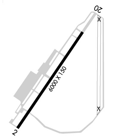
| Lat: N 4729.4 Long: W 12245.9 Elev: 444 Var: -16 Longest Runway: 6000 | ||
| Clr Del: 127.1 AWOS: 121.2 CTAF: 123.05 | ||
| ||||||||||||||||||||||||||||||||||||||||||||
| ||||||||||||||||||||||||||||||||||||||||||||
| ||||||||||||||||||||||||||||||||||||||||||||
| Rwy | Rwy | |||||||
| 6000x150 | 6000' | 6000x150 | 6000' | 111.10 - 196° | ||||
| Runway ID | Single Wheel | Double Wheel | Double Tandem Wheel | Dual Double Wheel |
| 02/20 | 66,000 | 150,000 | 336,000 | N/A |
| These numbers are Advisory and are not limits. The Airport Manager should have more accurate Weight Limits | ||||
 Airport Diagram might not be current. | |
| Facility Name: | BREMERTON NTL |
| City Name: | BREMERTON |
| County: | KITSAP |
| State abbrev: | WA |
| State Name: | WASHINGTON |
| Ownership: | PUBLICLY OWNED |
| Use: | OPEN TO THE PUBLIC |
| Owner's Name: | PORT OF BREMERTON |
| Address: | 8850 SW STATE HIGHWAY 3 |
| BREMERTON, WA 98312 | |
| Owner's Phone: | (360) 674-2381 |
| Manager's Name: | COLE BARNES |
| Address: | 8850 STATE HIGHWAY 3 SW |
| BREMERTON, WA 98312 | |
| Phone: | (360) 813-0828 |
| FAA Region: | NORTHWEST MOUNTAIN |
| FAA Field Office: | SEA |
| Date | Sunrise | Sunset |
|---|---|---|
| 06/05/26 Friday | 5:16 | 21:04 |
| 06/06/26 Saturday | 5:15 | 21:04 |
| 06/07/26 Sunday | 5:15 | 21:05 |
| 06/08/26 Monday | 5:14 | 21:06 |
| 06/09/26 Tuesday | 5:14 | 21:07 |
| 06/10/26 Wednesday | 5:14 | 21:07 |
| 06/11/26 Thursday | 5:14 | 21:08 |
| 06/12/26 Friday | 5:13 | 21:08 |
| 06/13/26 Saturday | 5:13 | 21:09 |
| 06/14/26 Sunday | 5:13 | 21:10 |
| 06/15/26 Monday | 5:13 | 21:10 |
| 06/16/26 Tuesday | 5:13 | 21:10 |
| 06/17/26 Wednesday | 5:13 | 21:11 |
| 06/18/26 Thursday | 5:13 | 21:11 |
| Airport Attendance Schedule | M-F 0800-1630 |
| Airport Status | OPERATIONAL (This Status can change at any time - please check NOTAMS) |
| Airport Lighting Schedule | ACTVT MALSR RWY 20; REIL RWY 02; PAPI RWY 02; HIRL 02/20; TWY LGTS - CTAF. PAPI RWY 20 OPR CONSLY. |
| Airport Storage Available | Tie Downs |
| Extra Services Available | Air Freight, Air Ambulance, Avionics, Charter, Flight Instruction, Aircraft Rental |
| Wind Indicator | YES - (lighted) |
| Control Tower | NO |
| CTAF Frequency | 123.050 |
| Unicom Frequency | 123.050 |
| Rotating Beacon Color | WG |
| Segmented Circle | YES |
| Landing Fee | NO |
| Airport Inspected | FEDERAL - performed by STATE AERONAUTICAL PERSONNEL |
| Inspection Date | 08/09/2023 |
| Type of Fuel Available | Grade 100LL, JET A (freeze point -40C); -1024 HR FUEL TRML 300 FT WSW OF TWY A4, ONLY FOR 100LL. |
| Airframe Repair Service | MAJOR |
| Power Plant Repair Service | MAJOR |
| Latitude | N4729.4 |
| Longitude | W12245.9 (ESTIMATED) |
| Arpt Elevation | 444ft (SURVEYED) |
| Magnetic Variation | 16E |
| 7 miles SW | of BREMERTON |
| Traffic Pattern Altitude | |
| Sectional Chart | SEATTLE |
| Operations (Reported) | Yearly | Avg. Daily |
|---|---|---|
| General Aviation Transient | 0 | 0 |
| General Aviation Local | 0 | 0 |
| Air Taxi | 0 | 0 |
| Commerical | 0 | 0 |
| Commuter | 0 | 0 |
| Military | 0 | 0 |
| Aircraft based on Field | |
|---|---|
| General Aviation Singles | 0 |
| General Aviation Multi | 0 |
| Jet Aircraft | 0 |
| General Aviation Helicopters | 0 |
| Military Aircraft | 0 |
| Gliders | 0 |
| Ultralights | 0 |
| FSS on field | NO |
| FSS tie-in | SEATTLE |
| FSS Phone | 1-800-WX-BRIEF |
| Who issues Notams | PWT |
| Notam D service at airport | YES |
| ARTCC Name | SEATTLE |
| Airport Certification | |
| Aircraft Rescue & Firefighting Index | None |
| Airport of Entry | No |
| Custom Landing Rights | No |
| Joint Civil/Military | No |
| Military Landing rights | YES |
| NATIONAL PLAN OF INTEGRATED AIRPORT SYSTEMS (NPIAS) |
| GRANT AGREEMENTS UNDER FAAP/ADAP/AIP |
| SURPLUS PROPERTY AGREEMENT UNDER PUBLIC LAW 289 |
| ASSURANCES PURSUANT TO TITLE VI, CIVIL RIGHTS ACT OF 1964 |
| AGREEMENT UNDER DLAND OR DCLA HAS EXPIRED. |
| THIS AIRPORT HAS BEEN SURVEYED BY THE NATIONAL GEODETIC SURVEY. |
| FOR CD CTC SEATTLE APCH AT 206-214-4723. |
| WINTER WEATHER OPS AND REPORTING MON - FRI 8:00-16:30. |
| FENCE CROSSES N END OF ABND RWY. |
Airport Communications & Frequencies:
| ||||||||||||||||||||||||
| Runway: 02 | Runway: 20 | ||
| Mag heading: | 17° | Mag heading: | 197° |
| Rwy Slope: | -.04% Down | Rwy Slope: | .04% Up |
| Approach: | Approach: | ILS | |
| Pattern: | Right Traffic | Pattern: | Left Traffic |
| Markings: | NONPRECISION INSTRUMENT | Markings: | PRECISION INSTRUMENT |
| Marking Condition: | GOOD | Marking Condition: | GOOD |
| Arresting Dev: | Arresting Dev: | ||
| Lat & Long: | N4729.0 W12246.3 | Lat. & Long.: | N4729.8 W12245.5 |
| Elev: | 444.0 ft. MSL | Elev: | 441.5 ft. MSL |
| TCH: | 43 ft. AGL | TCH: | 50 ft. AGL |
| Visual Glide Path: | 3.00 degrees | Visual Glide Path: | 2.83 degrees |
| Displaced Threshold: | No | Displaced Threshold: | No |
| Touchdown Zone: | YES | Touchdown Zone: | YES |
| Touchdown Elev.: | 444.0 feet | Touchdown Elev.: | 441.5 feet |
| Visual Glide Slope: | 4-Light PAPI on LEFT side of Runway | Visual Glide Slope: | 4-Light PAPI on LEFT side of Runway |
| RVR Equipment: | RVR Equipment: | ||
| RVV Equipment: | NO | RVV Equipment: | NO |
| Approach Lights: | Approach Lights: | MALSR - 1,400 foot medium intensity approach lighting system with runway alignment indicator lights | |
| REIL: | YES | REIL: | NO |
| Centerline Lights: | NO | Centerline Lights: | NO |
| Touchdown lights: | NO | Touchdown lights: | NO |
| Runway Category: | Runway with a Non-precision Approach having visibility minimums greater than 3/4 mile | Runway Category: | Precision Instrument Runway |
| Declared Distances: | Declared Distances: | ||
| Obstructions: | Obstructions: | FENCE | |
| Marked: | Marked: | NOT Marked/Lighted | |
| Clearance slope: | 50:1 | Clearance slope: | 46:1 |
| Obstruction height: | Obstruction height: | 33 feet AGL | |
| Dist. from runway: | Dist. from runway: | 1740 feet | |
| Centerline offset: | Centerline offset: | 300 feet left of centerline | |
| Comments: | +6 FT TRN 25 FT FM RWY END & 250 FT R. | Comments: | +6 FT' FENCE 0 TO 200 FT FM RWY END 300 FT R. |
Thanks for using FltPlan.com
all rights reserved © 1999-2026 by Flight Plan LLC
