| PORTAGE COUNTY RAVENNA OH |
| |
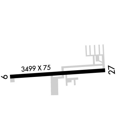
| Lat: N 4112.6 Long: W 08115.1 Elev: 1198 Var: +08 Longest Runway: 3499 | ||
| Clr Del: 125.65 AWOS: 118.67 CTAF: 123.05 | ||
| |||||||||||||||||||||||
| |||||||||||||||||||||||
| |||||||||||||||||||||||
| Rwy | Rwy | |||||||
| 3499x75 | 3499' | 3499x75 | 3499' | |||||
| Runway ID | Single Wheel | Double Wheel | Double Tandem Wheel | Dual Double Wheel |
| 09/27 | N/A | N/A | N/A | N/A |
| These numbers are Advisory and are not limits. The Airport Manager should have more accurate Weight Limits | ||||
 Airport Diagram might not be current. | |
| Facility Name: | PORTAGE COUNTY |
| City Name: | RAVENNA |
| County: | PORTAGE |
| State abbrev: | OH |
| State Name: | OHIO |
| Ownership: | PUBLICLY OWNED |
| Use: | OPEN TO THE PUBLIC |
| Owner's Name: | PORTAGE COUNTY COMISSIONERS |
| Address: | 449 S MERIDIAN ST |
| RAVENNA, OH 44266-2914 | |
| Owner's Phone: | 330-297-3600 |
| Manager's Name: | ROBERT HARTIGAN |
| Address: | 449 S MERIDIAN ST; ARPT PHYS ADS: 4039 NANWAY BLVD, RAVENNA, OH 44266-9705. |
| RAVENNA, OH 44266-2914 | |
| Phone: | 330-610-4618 |
| FAA Region: | GREAT LAKES |
| FAA Field Office: | DET |
| Date | Sunrise | Sunset |
|---|---|---|
| 05/02/25 Friday | 6:22 | 20:23 |
| 05/03/25 Saturday | 6:20 | 20:24 |
| 05/04/25 Sunday | 6:19 | 20:25 |
| 05/05/25 Monday | 6:18 | 20:26 |
| 05/06/25 Tuesday | 6:17 | 20:27 |
| 05/07/25 Wednesday | 6:15 | 20:28 |
| 05/08/25 Thursday | 6:14 | 20:29 |
| 05/09/25 Friday | 6:13 | 20:30 |
| 05/10/25 Saturday | 6:12 | 20:31 |
| 05/11/25 Sunday | 6:11 | 20:32 |
| 05/12/25 Monday | 6:10 | 20:33 |
| 05/13/25 Tuesday | 6:09 | 20:34 |
| 05/14/25 Wednesday | 6:08 | 20:35 |
| 05/15/25 Thursday | 6:07 | 20:36 |
| Airport Attendance Schedule | MON-FRI 0800-1600; UNATNDD ALL MAJOR HOLS. |
| Airport Status | OPERATIONAL (This Status can change at any time - please check NOTAMS) |
| Airport Lighting Schedule | ACTVT REIL RWY 09 & 27; PAPI RWY 27; MIRL RWY 09/27 - CTAF. |
| Airport Storage Available | Tie Downs, Hanger |
| Extra Services Available | NONE |
| Wind Indicator | YES - (lighted) |
| Control Tower | NO |
| CTAF Frequency | 123.050 |
| Unicom Frequency | 123.050 |
| Rotating Beacon Color | WG |
| Segmented Circle | NO |
| Landing Fee | NO |
| Airport Inspected | STATE - performed by STATE AERONAUTICAL PERSONNEL |
| Inspection Date | 09/15/2022 |
| Type of Fuel Available | Grade 100LL, JET A; -10FUEL AVBL H24 SELF SVC. |
| Airframe Repair Service | MAJOR |
| Power Plant Repair Service | MAJOR |
| Latitude | N4112.6 |
| Longitude | W08115.1 (ESTIMATED) |
| Arpt Elevation | 1197ft (SURVEYED) |
| Magnetic Variation | 08W |
| 3 miles N | of RAVENNA |
| Traffic Pattern Altitude | |
| Sectional Chart | DETROIT |
| Operations (Reported) | Yearly | Avg. Daily |
|---|---|---|
| General Aviation Transient | 0 | 0 |
| General Aviation Local | 0 | 0 |
| Air Taxi | 0 | 0 |
| Commerical | 0 | 0 |
| Commuter | 0 | 0 |
| Military | 0 | 0 |
| Aircraft based on Field | |
|---|---|
| General Aviation Singles | 0 |
| General Aviation Multi | 0 |
| Jet Aircraft | 0 |
| General Aviation Helicopters | 0 |
| Military Aircraft | 0 |
| Gliders | 0 |
| Ultralights | 0 |
| FSS on field | NO |
| FSS tie-in | CLEVELAND |
| FSS Phone | 1-800-WX-BRIEF |
| Who issues Notams | POV |
| Notam D service at airport | YES |
| ARTCC Name | CLEVELAND |
| Airport Certification | |
| Aircraft Rescue & Firefighting Index | None |
| Airport of Entry | No |
| Custom Landing Rights | No |
| Joint Civil/Military | No |
| Military Landing rights | No |
| NATIONAL PLAN OF INTEGRATED AIRPORT SYSTEMS (NPIAS) |
| DEER ON & INVOF ARPT. |
| PARAGLIDER OPS BY PERMIT ONLY. |
| FOR CD CTC CLEVELAND APCH AT 216-352-2323, WHEN APCH CLSD CTC CLEVELAND ARTCC AT 440-774-0223/0490. |
| FICON NOTAMS UNAVBL AFT HRS, WKENDS, & MAJOR HOLS. |
| RWY 09/2 7 ALL AREAS OFF RWY SFC SOFT WHEN WET OR THAWING. |
Airport Communications & Frequencies:
| |||||||||||||||||||
| Runway: 09 | Runway: 27 | ||
| Mag heading: | 93° | Mag heading: | 273° |
| Rwy Slope: | -.04% Down | Rwy Slope: | .04% Up |
| Approach: | Approach: | ||
| Pattern: | Left Traffic | Pattern: | Left Traffic |
| Markings: | NONPRECISION INSTRUMENT | Markings: | NONPRECISION INSTRUMENT |
| Marking Condition: | GOOD | Marking Condition: | GOOD |
| Arresting Dev: | Arresting Dev: | ||
| Lat & Long: | N4112.6 W08115.5 | Lat. & Long.: | N4112.6 W08114.7 |
| Elev: | 1194.3 ft. MSL | Elev: | 1192.9 ft. MSL |
| TCH: | TCH: | 43 ft. AGL | |
| Visual Glide Path: | Visual Glide Path: | 3.00 degrees | |
| Displaced Threshold: | No | Displaced Threshold: | No |
| Touchdown Zone: | YES | Touchdown Zone: | YES |
| Touchdown Elev.: | 1197.5 feet | Touchdown Elev.: | 1197.5 feet |
| Visual Glide Slope: | Visual Glide Slope: | 4-Light PAPI on LEFT side of Runway | |
| RVR Equipment: | RVR Equipment: | ||
| RVV Equipment: | NO | RVV Equipment: | NO |
| Approach Lights: | Approach Lights: | ||
| REIL: | YES | REIL: | YES |
| Centerline Lights: | NO | Centerline Lights: | NO |
| Touchdown lights: | NO | Touchdown lights: | NO |
| Runway Category: | Runway with a Non-precision Approach | Runway Category: | Runway with a Non-precision Approach |
| Declared Distances: | Declared Distances: |
Thanks for using FltPlan.com
all rights reserved © 1999-2025 by Flight Plan LLC