
| POLK AAF (PRIVATE) FORT POLK LA |
| |
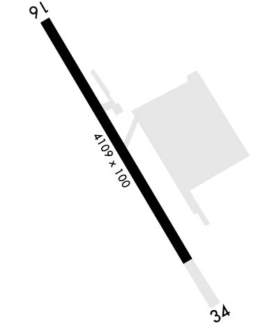
| Lat: N 3102.7 Long: W 09311.5 Elev: 330 Var: -02 Longest Runway: 4107 | ||
| Dept. ATIS: 134.85 Arr. ATIS: 134.85 Ground: 121.8 Tower: 119.0 | ||
| ||||||||||||||||||||||||||||||||
| ||||||||||||||||||||||||||||||||
| ||||||||||||||||||||||||||||||||
| Rwy | Rwy | |||||||
| 4107x100 | 3913' | 4107x100 | 4107' | |||||
| Runway ID | Single Wheel | Double Wheel | Double Tandem Wheel | Dual Double Wheel |
| 16/34 | N/A | N/A | N/A | N/A |
| These numbers are Advisory and are not limits. The Airport Manager should have more accurate Weight Limits | ||||
 Airport Diagram might not be current. | |
| Facility Name: | POLK AAF |
| City Name: | FORT POLK |
| County: | VERNON |
| State abbrev: | LA |
| State Name: | LOUISIANA |
| Ownership: | ARMY OWNED |
| Use: | PRIVATE |
| Owner's Name: | U.S.ARMY |
| Address: | AVIATION DIVISION DPTM |
| FT FOLK, LA 71459-5000 | |
| Owner's Phone: | 318-535-2314 |
| Manager's Name: | AIRFIELD COMMANDER |
| Address: | AVIATION DIVISION DITM |
| FT POLK, LA 71459-5000 | |
| Phone: | 337-531-6195 |
| FAA Region: | SOUTHWEST |
| FAA Field Office: | LNM |
| Date | Sunrise | Sunset |
|---|---|---|
| 09/24/21 Friday | 7:02 | 19:07 |
| 09/25/21 Saturday | 7:03 | 19:06 |
| 09/26/21 Sunday | 7:03 | 19:04 |
| 09/27/21 Monday | 7:04 | 19:03 |
| 09/28/21 Tuesday | 7:04 | 19:02 |
| 09/29/21 Wednesday | 7:05 | 19:01 |
| 09/30/21 Thursday | 7:06 | 18:59 |
| 10/01/21 Friday | 7:06 | 18:58 |
| 10/02/21 Saturday | 7:07 | 18:57 |
| 10/03/21 Sunday | 7:08 | 18:56 |
| 10/04/21 Monday | 7:08 | 18:54 |
| 10/05/21 Tuesday | 7:09 | 18:53 |
| 10/06/21 Wednesday | 7:09 | 18:52 |
| 10/07/21 Thursday | 7:10 | 18:51 |
| Airport Attendance Schedule | MON-FRI 1300-0500Z++, SAT-SUN 1300-2100Z++; CLSD FEDERAL HOLS. |
| Airport Status | OPERATIONAL (This Status can change at any time - please check NOTAMS) |
| Airport Lighting Schedule | SS-SR |
| Airport Storage Available | NONE |
| Extra Services Available | NONE |
| Wind Indicator | YES - (unlit) |
| Control Tower | YES |
| CTAF Frequency | 119.000 |
| Unicom Frequency | |
| Rotating Beacon Color | CLEAR-GREEN (Light Land Airport) |
| Segmented Circle | NO |
| Landing Fee | NO |
| Airport Inspected | No Inspection Data Available performed by STATE AERONAUTICAL PERSONNEL |
| Inspection Date | 12/23/1986 |
| Type of Fuel Available | None |
| Airframe Repair Service | NONE |
| Power Plant Repair Service | NONE |
| Latitude | N3102.7 |
| Longitude | W09311.5 (ESTIMATED) |
| Arpt Elevation | 330ft (SURVEYED) |
| Magnetic Variation | 02E |
| 7 miles SE | of FORT POLK |
| Traffic Pattern Altitude | |
| Sectional Chart | HOUSTON |
| Operations (Reported) | Yearly | Avg. Daily |
|---|---|---|
| General Aviation Transient | 900 | 2 |
| General Aviation Local | 2500 | 7 |
| Air Taxi | 4056 | 11 |
| Commerical | 0 | 0 |
| Commuter | 0 | 0 |
| Military | 160000 | 438 |
| Aircraft based on Field | |
|---|---|
| General Aviation Singles | 3 |
| General Aviation Multi | 2 |
| Jet Aircraft | 0 |
| General Aviation Helicopters | 120 |
| Military Aircraft | 120 |
| Gliders | 0 |
| Ultralights | 0 |
| FSS on field | NO |
| FSS tie-in | DE RIDDER |
| FSS Phone | 1-800-WX-BRIEF |
| Who issues Notams | POE |
| Notam D service at airport | YES |
| ARTCC Name | HOUSTON |
| Airport Certification | |
| Aircraft Rescue & Firefighting Index | None |
| Airport of Entry | No |
| Custom Landing Rights | No |
| Joint Civil/Military | No |
| Military Landing rights | No |
| TFC PAT: ALL PAT W OF FLD. F/W TFC 1800' R/W TFC 1000'. |
| SEE FLIP AP/1 SUPPLEMENTARY ARPT INFO. |
| PRIOR PERMISSION REQUIRED (PPR)-FIXED WING AIRCRAFT ONLY MUST OBTAIN A PPR NUMBER AT DSN 863-4831, C337-531-4831. |
| AIRFIELD OPERATIONS CONTACT NUMBER IS DSN 863-4831, C337-531-4831. UNITS UTILIZING RANGE FACILITY/RESTRICTED AREAS OR STAGING OPERATIONS AT POLK AAF (KPOE) MUST CONTACT AT&A OFFICER AT DSN 863-1151, C337-531-1151 FOR BRIEFING. |
| MISC: SFC VIS OBSN BLOCKED NW-SE BY HILLS, BLDG AND TREES. |
| AFLD MGMT OPR 1300-0500++ MON-FRI, 1500-2300++ SAT-SUN.TWR-OPR 1300-0500Z++ DLY. AFLD MGMT OPR CLSD HOL. |
| C130 PRKG LTD TO 2 ACFT. C130 MAY LND ONLY WHEN PRKG IS AVBL |
| WHEN ATCT CLSD, FOR CD CTC POLK APP 123.7, 261.3. |
| WX SVC AVBL 1300-0500Z++ DLY, CLSD HOL, DSN 863-4100, C337-531-4100. WX SENSOR AUTOMATED 24/7. HOURS WILL VARY WITH LCL MSN SKED. |
| SERVICE-FUEL: A++. |
| OIL: O-156. |
| SERVICE TRAN ALERT: LTD SVC. |
| MISC: S-VFR DALGT 500-1, NGT UNAIDED/NVD 500-2. |
Airport Communications & Frequencies:
| |||||||||||||||||||||||||||||
| Runway: 16 | Runway: 34 | ||
| Mag heading: | 158° | Mag heading: | 338° |
| Rwy Slope: | -1.26% Down | Rwy Slope: | 1.26% Up |
| Approach: | Approach: | ||
| Pattern: | Left Traffic | Pattern: | Left Traffic |
| Markings: | NONPRECISION INSTRUMENT | Markings: | NONPRECISION INSTRUMENT |
| Marking Condition: | GOOD | Marking Condition: | GOOD |
| Arresting Dev: | Arresting Dev: | ||
| Lat & Long: | N3103.0 W09311.6 | Lat. & Long.: | N3102.4 W09311.4 |
| Elev: | 329.4 ft. MSL | Elev: | 277.5 ft. MSL |
| TCH: | 44 ft. AGL | TCH: | 45 ft. AGL |
| Visual Glide Path: | 3.00 degrees | Visual Glide Path: | 3.00 degrees |
| Displaced Threshold: | 194 feet | Displaced Threshold: | No |
| Touchdown Zone: | YES | Touchdown Zone: | YES |
| Touchdown Elev.: | 328.3 feet | Touchdown Elev.: | 321.3 feet |
| Visual Glide Slope: | 4-Light PAPI on RIGHT side of Runway | Visual Glide Slope: | 4-Light PAPI on LEFT side of Runway |
| RVR Equipment: | RVR Equipment: | ||
| RVV Equipment: | NO | RVV Equipment: | NO |
| Approach Lights: | Approach Lights: | ALSF1 - standard 2,400 foot high intensity approach lighting system with sequenced flashers, Category I | |
| REIL: | YES | REIL: | YES |
| Centerline Lights: | NO | Centerline Lights: | NO |
| Touchdown lights: | NO | Touchdown lights: | NO |
| Runway Category: | Precision Instrument Runway | Runway Category: | Precision Instrument Runway |
| Declared Distances: | Declared Distances: | ||
| Obstructions: | TREES | Obstructions: | TREES |
| Marked: | NOT Marked/Lighted | Marked: | NOT Marked/Lighted |
| Clearance slope: | 26:1 | Clearance slope: | 29:1 |
| Obstruction height: | Obstruction height: | ||
| Dist. from runway: | 1500 feet | Dist. from runway: | 2500 feet |
| Centerline offset: | Centerline offset: | ||
| Comments: | 4' SIDE FENCES 200' FM CNTRLN BOTH RWY ENDS. | Comments: |
Thanks for using FltPlan.com
all rights reserved © 1999-2021 by Flight Plan LLC
