
| PHOENIX SKY HARBOR INTL PHOENIX AZ |
| |
| Lat: N 3326.1 Long: W 11200.7 Elev: 1135 Var: -12 Longest Runway: 11489 | ||
| Clr Del: 118.1 Dept. ATIS: 127.57 Arr. ATIS: 127.57 Ground: 119.75/132.55 Tower: 118.7/120.9 | ||
| |||||||||||||||||||||||||||||||||||||||||||||||||||||||||||||||||||||
| |||||||||||||||||||||||||||||||||||||||||||||||||||||||||||||||||||||
| |||||||||||||||||||||||||||||||||||||||||||||||||||||||||||||||||||||
| |||||||||||||||||||||||||||||||||||||||||||||||||||||||||||||||||||||
| |||||||||||||||||||||||||||||||||||||||||||||||||||||||||||||||||||||
| FBOs at nearby airports who want your business: | |||||||||||||||||
| |||||||||||||||||
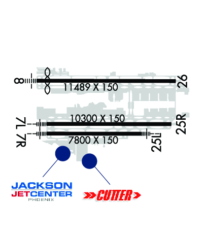
| Rwy | Rwy | |||||||
| 10300x150 | 10300' | 111.50 - 078° | 10300x150 | 10300' | ||||
| 7800x150 | 7800' | 110.75 - 078° | 7800x150 | 7800' | 110.75 - 258° | |||
| 11489x150 | 10591' | 111.75 - 078° | 11489x150 | 11489' | 111.75 - 258° | |||
| Runway ID | Single Wheel | Double Wheel | Double Tandem Wheel | Dual Double Wheel |
| 07L/25R | 30,000 | 235,000 | 435,000 | 940,000 |
| 07R/25L | 30,000 | 200,000 | 400,000 | 1,010,000 |
| 08/26 | 30,000 | 200,000 | 455,000 | 965,000 |
| These numbers are Advisory and are not limits. The Airport Manager should have more accurate Weight Limits | ||||
 Airport Diagram might not be current. | |
| Facility Name: | PHOENIX SKY HARBOR INTL |
| City Name: | PHOENIX |
| County: | MARICOPA |
| State abbrev: | AZ |
| State Name: | ARIZONA |
| Ownership: | PUBLICLY OWNED |
| Use: | OPEN TO THE PUBLIC |
| Owner's Name: | CITY OF PHOENIX |
| Address: | 2485 E BUCKEYE RD |
| PHOENIX, AZ 85034 | |
| Owner's Phone: | 602-273-3302 |
| Manager's Name: | CHAD MAKOVSKY; 24 HR DUTY MGR 602-273-3388; AIRSIDE OPS OFC 602-273-2008; OPS SUPT 602-273-2072. |
| Address: | 2485 E BUCKEYE RD |
| PHOENIX, AZ 85034 | |
| Phone: | 602-273-3302 |
| FAA Region: | WESTERN-PACIFIC |
| FAA Field Office: | PHX |
| Date | Sunrise | Sunset |
|---|---|---|
| 02/05/26 Thursday | 7:21 | 18:03 |
| 02/06/26 Friday | 7:20 | 18:04 |
| 02/07/26 Saturday | 7:20 | 18:05 |
| 02/08/26 Sunday | 7:19 | 18:06 |
| 02/09/26 Monday | 7:18 | 18:07 |
| 02/10/26 Tuesday | 7:17 | 18:08 |
| 02/11/26 Wednesday | 7:16 | 18:09 |
| 02/12/26 Thursday | 7:15 | 18:10 |
| 02/13/26 Friday | 7:14 | 18:11 |
| 02/14/26 Saturday | 7:13 | 18:12 |
| 02/15/26 Sunday | 7:12 | 18:13 |
| 02/16/26 Monday | 7:11 | 18:14 |
| 02/17/26 Tuesday | 7:10 | 18:15 |
| 02/18/26 Wednesday | 7:09 | 18:15 |
| Airport Attendance Schedule | CONTINUOUS |
| Airport Status | OPERATIONAL (This Status can change at any time - please check NOTAMS) |
| Airport Lighting Schedule | |
| Airport Storage Available | Tie Downs, Hanger |
| Extra Services Available | Air Freight, Air Ambulance, Avionics, Cargo Handling, Charter, Aircraft Sales |
| Wind Indicator | YES - (lighted) |
| Control Tower | YES |
| CTAF Frequency | |
| Unicom Frequency | |
| Rotating Beacon Color | WG |
| Segmented Circle | NO |
| Landing Fee | YES; OVNGT PRKG FEE. |
| Airport Inspected | FEDERAL - performed by FAA AIRPORTS FIELD PERSONNEL |
| Inspection Date | 09/12/2024 |
| Type of Fuel Available | Grade 100LL, JET A (freeze point -40C) |
| Airframe Repair Service | MAJOR |
| Power Plant Repair Service | MAJOR |
| Latitude | N3326.1 |
| Longitude | W11200.7 (ESTIMATED) |
| Arpt Elevation | 1134ft (SURVEYED) |
| Magnetic Variation | 12E |
| 3 miles E | of PHOENIX |
| Traffic Pattern Altitude | TPA: 1000 FT AGL LGT ACFT & NON-TURBOJETS; 1500 FT AGL HVY ACFT & TURBOJETS. |
| Sectional Chart | PHOENIX |
| Operations (Reported) | Yearly | Avg. Daily |
|---|---|---|
| General Aviation Transient | 0 | 0 |
| General Aviation Local | 0 | 0 |
| Air Taxi | 0 | 0 |
| Commerical | 0 | 0 |
| Commuter | 0 | 0 |
| Military | 0 | 0 |
| Aircraft based on Field | |
|---|---|
| General Aviation Singles | 0 |
| General Aviation Multi | 0 |
| Jet Aircraft | 0 |
| General Aviation Helicopters | 0 |
| Military Aircraft | 0 |
| Gliders | 0 |
| Ultralights | 0 |
| FSS on field | NO |
| FSS tie-in | PRESCOTT |
| FSS Phone | 1-800-WX-BRIEF |
| Who issues Notams | PHX |
| Notam D service at airport | YES |
| ARTCC Name | ALBUQUERQUE |
| Airport Certification | AIRPORT RECEIVING SCHEDULED AIR CARRIER SERVICE FROM CARRIERS CERTIFICATED BY THE CIVIL AERONAUTICS BOARD |
| Aircraft Rescue & Firefighting Index | AIRPORT HAS A CERTIFICATE UNDER CFR PART 139 |
| Airport of Entry | No |
| Custom Landing Rights | YES |
| Joint Civil/Military | No |
| Military Landing rights | YES |
| NATIONAL PLAN OF INTEGRATED AIRPORT SYSTEMS (NPIAS) |
| GRANT AGREEMENTS UNDER FAAP/ADAP/AIP |
| SURPLUS PROPERTY AGREEMENT UNDER REGULATION 16-WAA |
| CONVEYANCE UNDER SCETION 16, FEDERAL AIRPORT ACT OF 1946 OR SECTION 23, AIRPORT AND AIRWAY DEVELOPMENT ACT OF 1970 |
| ASSURANCES PURSUANT TO TITLE VI, CIVIL RIGHTS ACT OF 1964 |
| NOISE ABATEMENT PROC IN EFCT. |
| TWY R & PTNS OF TWY S & T BLW ATCT NOT VSB FM ATCT. |
| TWY R OVHD TRAIN BRIDGE AT MIDPT PRVDS 81 FT 9 IN CLNC. TXL Y3 OVHD TRAIN BRIDGE AT MIDPT PRVDS 44 FT 7 IN CLNC. |
| EXPERIMENTAL OR GND DMSTN NA WO PRIOR APVL - AIRSIDE OPS. |
| ANG: OFFL BUS ONLY; BASH PHASE II IN EFCT 1 MAR - 31 MAY & 1 AUG - 31 OCT; LTD RAMP SPACE AVBL - 602-273-3770. |
| PPR WINGSPAN 215 FT OR GTR GROUP VI - OPS 602-273-2008 FOR FOLLOW ME SVC WHILE TAX TO & FM RAMP & RWYS. |
| PRAC INST APCH, STOP & TAX BACK LDG, STOP & GO LDG, TGL NA. OTR FLIGHT TRNG OPS NA WO PRIOR WRITTEN APVL - AIRSIDE OPS 602-273-2008. |
| ENG RUNS NA WO PRIOR COORD WITH AIRSIDE OPS. |
| INTL GATE USE RQR CDN WITH ARPT OPS 48 HR PRIOR TO ARR. |
| INTL LDG RIGHTS RQR US CUST & BDR PROTECTION NOTIFICATION 48 HR PRIOR TO LDG. |
| REVIEW HOT SPOT INFO ON ARPT DIAGRAM. |
| RWY STATUS LGTS IN OPRN. |
| GEN INFO - 602-273-3302. |
| FEE FOR CHARTERS, TRAVEL CLUB & REVENUE PRODUCING ACFT. |
| TWYS A BTN A3 AND A10, A4, A5, A6, A7, A8, A9 CLSD TO ACFT WINGSPAN OF MORE THAN 125FT. |
| TWY A BTN INT A11 & A12, A12, D BTN INT D13 TO R, D13, F BTW INT G2 & G3 CLSD TO WINGSPAN GTR THAN 135 FT. |
| TWY C BTN TXL I & C9, BTN C9 & C10, BTN C10 & C11, BTN C11 & Q, TWY D BTN D8 & T, D9, TWY H BTN TWY H4 & H7, H5, H6, H7 CLSD TO WINGSPAN GTR THAN 171 FT. |
| TWY D BTN S & D13, D10, D11, D12 CLSD TO WINGSPAN GTR THAN 118 FT. |
| RWY 07L/ 25RPCR VALUE: 674/R/A/W/T |
| RWY 07R/ 25LPCR VALUE: 796/R/A/W/T |
| RWY 08/2 6 PCR VALUE: 846/R/A/W/T |
Airport Communications & Frequencies:
| |||||||||||||||||||||||||||||||||||||||||||||||||||||||||||||||||||||||||||||||||||||||||||||||||||||||||||||||||||||||||||||||||||||||||||||||||||||||||||||||||||||||
| Runway: 07L | Runway: 25R | ||
| Mag heading: | 78° | Mag heading: | 258° |
| Rwy Slope: | .23% Up | Rwy Slope: | -.23% Down |
| Approach: | ILS/DME | Approach: | |
| Pattern: | Right Traffic | Pattern: | Left Traffic |
| Markings: | PRECISION INSTRUMENT | Markings: | PRECISION INSTRUMENT |
| Marking Condition: | GOOD | Marking Condition: | GOOD |
| Arresting Dev: | Arresting Dev: | ||
| Lat & Long: | N3325.9 W11201.6 | Lat. & Long.: | N3325.9 W11159.6 |
| Elev: | 1110.2 ft. MSL | Elev: | 1134.0 ft. MSL |
| TCH: | 73 ft. AGL | TCH: | 70 ft. AGL |
| Visual Glide Path: | 3.00 degrees | Visual Glide Path: | 3.00 degrees |
| Displaced Threshold: | No | Displaced Threshold: | No |
| Touchdown Zone: | YES | Touchdown Zone: | YES |
| Touchdown Elev.: | 1116.5 feet | Touchdown Elev.: | 1134.1 feet |
| Visual Glide Slope: | 4-Light PAPI on LEFT side of Runway | Visual Glide Slope: | 4-Light PAPI on LEFT side of Runway |
| RVR Equipment: | TOUCHDOWN | RVR Equipment: | ROLLOUT |
| RVV Equipment: | NO | RVV Equipment: | NO |
| Approach Lights: | MALSR - 1,400 foot medium intensity approach lighting system with runway alignment indicator lights | Approach Lights: | |
| REIL: | NO | REIL: | NO |
| Centerline Lights: | NO | Centerline Lights: | NO |
| Touchdown lights: | NO | Touchdown lights: | NO |
| Runway Category: | Precision Instrument Runway | Runway Category: | Runway with a Non-precision Approach having visibility minimums greater than 3/4 mile |
| Declared Distances: | TORA:10300' TODA:10300' ASDA:10300' LDA:10300' | Declared Distances: | TORA:10300' TODA:10300' ASDA:10300' LDA:10300' |
| Obstructions: | POLE | Obstructions: | ANT |
| Marked: | NOT Marked/Lighted | Marked: | MARKED and LIGHTED |
| Clearance slope: | 44:1 | Clearance slope: | 41:1 |
| Obstruction height: | 62 feet AGL | Obstruction height: | 416 feet AGL |
| Dist. from runway: | 2958 feet | Dist. from runway: | 17582 feet |
| Centerline offset: | 750 right of centerline | Centerline offset: | 600 feet left of centerline |
| Comments: | Comments: |
| Runway: 07R | Runway: 25L | ||
| Mag heading: | 78° | Mag heading: | 258° |
| Rwy Slope: | .20% Up | Rwy Slope: | -.20% Down |
| Approach: | ILS/DME | Approach: | ILS/DME |
| Pattern: | Left Traffic | Pattern: | Left Traffic |
| Markings: | PRECISION INSTRUMENT | Markings: | PRECISION INSTRUMENT |
| Marking Condition: | GOOD | Marking Condition: | GOOD |
| Arresting Dev: | Arresting Dev: | ||
| Lat & Long: | N3325.7 W11201.6 | Lat. & Long.: | N3325.7 W11200.1 |
| Elev: | 1111.0 ft. MSL | Elev: | 1126.3 ft. MSL |
| TCH: | 70 ft. AGL | TCH: | 66 ft. AGL |
| Visual Glide Path: | 3.00 degrees | Visual Glide Path: | 3.00 degrees |
| Displaced Threshold: | No | Displaced Threshold: | No |
| Touchdown Zone: | YES | Touchdown Zone: | YES |
| Touchdown Elev.: | 1115.9 feet | Touchdown Elev.: | 1126.4 feet |
| Visual Glide Slope: | 4-Light PAPI on LEFT side of Runway | Visual Glide Slope: | 4-Light PAPI on LEFT side of Runway |
| RVR Equipment: | RVR Equipment: | ||
| RVV Equipment: | NO | RVV Equipment: | NO |
| Approach Lights: | MALSR - 1,400 foot medium intensity approach lighting system with runway alignment indicator lights | Approach Lights: | MALSR - 1,400 foot medium intensity approach lighting system with runway alignment indicator lights |
| REIL: | NO | REIL: | NO |
| Centerline Lights: | NO | Centerline Lights: | NO |
| Touchdown lights: | NO | Touchdown lights: | NO |
| Runway Category: | Precision Instrument Runway | Runway Category: | Precision Instrument Runway |
| Declared Distances: | TORA:7800' TODA:7800' ASDA:7800' LDA:7800' | Declared Distances: | TORA:7800' TODA:7800' ASDA:7800' LDA:7800' |
| Obstructions: | POLE | Obstructions: | ANT |
| Marked: | LIGHTED | Marked: | MARKED and LIGHTED |
| Clearance slope: | 20:1 | Clearance slope: | 46:1 |
| Obstruction height: | 33 feet AGL | Obstruction height: | 424 feet AGL |
| Dist. from runway: | 900 feet | Dist. from runway: | 20059 feet |
| Centerline offset: | 640 right of centerline | Centerline offset: | 1193 feet left of centerline |
| Comments: | Comments: |
| Runway: 08 | Runway: 26 | ||
| Mag heading: | 78° | Mag heading: | 258° |
| Rwy Slope: | .21% Up | Rwy Slope: | -.21% Down |
| Approach: | ILS/DME | Approach: | ILS/DME |
| Pattern: | Left Traffic | Pattern: | Right Traffic |
| Markings: | PRECISION INSTRUMENT | Markings: | PRECISION INSTRUMENT |
| Marking Condition: | GOOD | Marking Condition: | GOOD |
| Arresting Dev: | Arresting Dev: | ||
| Lat & Long: | N3326.5 W11201.8 | Lat. & Long.: | N3326.4 W11159.5 |
| Elev: | 1111.1 ft. MSL | Elev: | 1134.7 ft. MSL |
| TCH: | 69 ft. AGL | TCH: | 71 ft. AGL |
| Visual Glide Path: | 3.00 degrees | Visual Glide Path: | 3.00 degrees |
| Displaced Threshold: | 898 feet | Displaced Threshold: | No |
| Touchdown Zone: | YES | Touchdown Zone: | YES |
| Touchdown Elev.: | 1118.0 feet | Touchdown Elev.: | 1134.8 feet |
| Visual Glide Slope: | 4-Light PAPI on LEFT side of Runway | Visual Glide Slope: | 4-Light PAPI on LEFT side of Runway |
| RVR Equipment: | RVR Equipment: | ||
| RVV Equipment: | NO | RVV Equipment: | NO |
| Approach Lights: | MALSF - 1,400 foot medium intensity approach lighting system with sequenced flashers | Approach Lights: | |
| REIL: | NO | REIL: | YES |
| Centerline Lights: | NO | Centerline Lights: | NO |
| Touchdown lights: | NO | Touchdown lights: | NO |
| Runway Category: | Precision Instrument Runway | Runway Category: | Precision Instrument Runway |
| Declared Distances: | TORA:11489' TODA:11489' ASDA:11489' LDA:10591' | Declared Distances: | TORA:11489' TODA:11489' ASDA:11489' LDA:11489' |
| Obstructions: | BLDG | Obstructions: | ROAD |
| Marked: | NOT Marked/Lighted | Marked: | NOT Marked/Lighted |
| Clearance slope: | 42:1 | Clearance slope: | 50:1 |
| Obstruction height: | 66 feet AGL | Obstruction height: | 9 feet AGL |
| Dist. from runway: | 3020 feet | Dist. from runway: | 905 feet |
| Centerline offset: | 503 left of centerline | Centerline offset: | 540 feet right of centerline |
| Comments: | Comments: |
Thanks for using FltPlan.com
all rights reserved © 1999-2026 by Flight Plan LLC