| TED STEVENS ANCHORAGE INTL ANCHORAGE AK |
| |
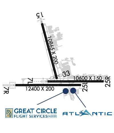
| Lat: N 6110.4 Long: W 14959.9 Elev: 151 Var: -16 Longest Runway: 12400 | ||
| Clr Del: 119.4/128.65 Dept. ATIS: 135.5 Arr. ATIS: 135.5 Ground: 121.9 Tower: 118.3 | ||
| |||||||||||||||||||||||||||||||||||||||||||||||||||||||||||||||||||
| |||||||||||||||||||||||||||||||||||||||||||||||||||||||||||||||||||
| |||||||||||||||||||||||||||||||||||||||||||||||||||||||||||||||||||
| |||||||||||||||||||||||||||||||||||||||||||||||||||||||||||||||||||
| |||||||||||||||||||||||||||||||||||||||||||||||||||||||||||||||||||
| |||||||||||||||||||||||||||||||||||||||||||||||||||||||||||||||||||
| |||||||||||||||||||||||||||||||||||||||||||||||||||||||||||||||||||
| Rwy | Rwy | |||||||
| 10600x150 | 10600' | 109.90 - 073° | 10600x150 | 10600' | ||||
| 12400x200 | 12400' | 111.30 - 073° | 12400x200 | 12400' | ||||
| 10865x200 | 10865' | 111.75 - 148° | 10865x200 | 10400' | ||||
| Runway ID | Single Wheel | Double Wheel | Double Tandem Wheel | Dual Double Wheel |
| 07L/25R | 120,000 | 250,000 | 550,000 | 1,120,000 |
| 07R/25L | 120,000 | 250,000 | 550,000 | 1,120,000 |
| 15/33 | 120,000 | 250,000 | 550,000 | 1,120,000 |
| These numbers are Advisory and are not limits. The Airport Manager should have more accurate Weight Limits | ||||
 Airport Diagram might not be current. | |
| Facility Name: | TED STEVENS ANCHORAGE INTL |
| City Name: | ANCHORAGE |
| County: | ANCHORAGE |
| State abbrev: | AK |
| State Name: | ALASKA |
| Ownership: | PUBLICLY OWNED |
| Use: | OPEN TO THE PUBLIC |
| Owner's Name: | STATE OF ALASKA DOTPF |
| Address: | BOX 196960 |
| ANCHORAGE, AK 99519-6960 | |
| Owner's Phone: | 907-266-2600 |
| Manager's Name: | AARON DANIELSON |
| Address: | BOX 196960 |
| ANCHORAGE, AK 99519-6960 | |
| Phone: | 907-266-2545 |
| FAA Region: | ALASKA |
| FAA Field Office: | NONE |
| Date | Sunrise | Sunset |
|---|---|---|
| 05/03/26 Sunday | 5:46 | 22:10 |
| 05/04/26 Monday | 5:43 | 22:12 |
| 05/05/26 Tuesday | 5:40 | 22:15 |
| 05/06/26 Wednesday | 5:37 | 22:18 |
| 05/07/26 Thursday | 5:34 | 22:20 |
| 05/08/26 Friday | 5:32 | 22:23 |
| 05/09/26 Saturday | 5:29 | 22:25 |
| 05/10/26 Sunday | 5:26 | 22:28 |
| 05/11/26 Monday | 5:23 | 22:31 |
| 05/12/26 Tuesday | 5:21 | 22:33 |
| 05/13/26 Wednesday | 5:18 | 22:36 |
| 05/14/26 Thursday | 5:16 | 22:38 |
| 05/15/26 Friday | 5:13 | 22:41 |
| 05/16/26 Saturday | 5:11 | 22:43 |
| Airport Attendance Schedule | CONTINUOUS |
| Airport Status | OPERATIONAL (This Status can change at any time - please check NOTAMS) |
| Airport Lighting Schedule | |
| Airport Storage Available | Tie Downs, Hanger |
| Extra Services Available | Cargo Handling |
| Wind Indicator | YES - (lighted) |
| Control Tower | YES |
| CTAF Frequency | |
| Unicom Frequency | 122.950 |
| Rotating Beacon Color | WG |
| Segmented Circle | NO |
| Landing Fee | YES |
| Airport Inspected | FEDERAL - performed by FAA AIRPORTS FIELD PERSONNEL |
| Inspection Date | 09/08/2025 |
| Type of Fuel Available | Grade 100, Grade 100LL, JET A (freeze point -40C), JET A-1 (freeze point -50C) |
| Airframe Repair Service | MAJOR |
| Power Plant Repair Service | MAJOR |
| Latitude | N6110.4 |
| Longitude | W14959.9 (ESTIMATED) |
| Arpt Elevation | 151ft (SURVEYED) |
| Magnetic Variation | 16E |
| 4 miles SW | of ANCHORAGE |
| Traffic Pattern Altitude | |
| Sectional Chart | ANCHORAGE |
| Operations (Reported) | Yearly | Avg. Daily |
|---|---|---|
| General Aviation Transient | 0 | 0 |
| General Aviation Local | 0 | 0 |
| Air Taxi | 0 | 0 |
| Commerical | 0 | 0 |
| Commuter | 0 | 0 |
| Military | 0 | 0 |
| Aircraft based on Field | |
|---|---|
| General Aviation Singles | 0 |
| General Aviation Multi | 0 |
| Jet Aircraft | 0 |
| General Aviation Helicopters | 0 |
| Military Aircraft | 0 |
| Gliders | 0 |
| Ultralights | 0 |
| FSS on field | NO |
| FSS tie-in | KENAI |
| FSS Phone | 1-800-866-864-1737 |
| Who issues Notams | ANC |
| Notam D service at airport | YES |
| ARTCC Name | ANCHORAGE |
| Airport Certification | AIRPORT RECEIVING SCHEDULED AIR CARRIER SERVICE FROM CARRIERS CERTIFICATED BY THE CIVIL AERONAUTICS BOARD |
| Aircraft Rescue & Firefighting Index | AIRPORT HAS A CERTIFICATE UNDER CFR PART 139 |
| Airport of Entry | No |
| Custom Landing Rights | YES |
| Joint Civil/Military | No |
| Military Landing rights | YES |
| NATIONAL PLAN OF INTEGRATED AIRPORT SYSTEMS (NPIAS) |
| GRANT AGREEMENTS UNDER FAAP/ADAP/AIP |
| CONVEYANCE UNDER SCETION 16, FEDERAL AIRPORT ACT OF 1946 OR SECTION 23, AIRPORT AND AIRWAY DEVELOPMENT ACT OF 1970 |
| ASSURANCES PURSUANT TO TITLE VI, CIVIL RIGHTS ACT OF 1964 |
| BIRDS INVOF ARPT SPRING - FALL. |
| 489 FT UNLGTD TWR 2.5 MI NE. |
| NON-RADIO NIGHT OPS NA; NON-PARROT OPS 1 HR PPR; NON-RADIO OPS PPR; MUST PRVD ETA & REMAIN WI 15 MIN - ATCT 907-271-2700 WKDAYS 0730-1600; AFT HR & HOL - FAA 907-271-5936. |
| PTNS OF TWY K BTN TWY H & J NOT VIS FM ATCT. |
| COMPASS CLBR PAD N/A. |
| R TURN OUT OF RAMP PRKG R-2 THRU R-4 NA. |
| FLT PLANNING IN ANCHORAGE BOWL AREA - RCO 122.55. |
| FAA RAMP PPR WITH ANC FIFO MON-FRI 0600-1430 - 135.85 OR 907-271-2414 OR AVN 405-954-9780. |
| ANCHORAGE WX CAMERA AVBL ON INTERNET AT HTTPS://WEATHERCAMS.FAA.GOV. |
| TWY V RSTRD TO 12500 LB OR LESS; SUBJECT TO JET BLAST W OF TWY E. |
| TSNT MIL PPR. |
| NOISE SENSITIVE AREA S & E; RWY 07R, 07L, 15 TBJT/TURBOFAN DEP EMPLOY FAA CLOSE IN NADP OR ICAO PROC B NADP WHEN SAFETY PERMITS; INFO - AMGR. |
| TWY V, SCTY GATE E OF TWY E - PCL 121.75 5 TIMES; TWY H-2, LAKESHORE TWY GATES - PCL 121.75 3 TIMES; IF INOP ALLOW 30 SEC RESET & NOTIFY LHD OPS - 907-266-2600. |
| PPR FOR GND TIME GTR THAN 4 HR AT ARPT CTL SPOTS; APVL REQ 48 HR PRIOR TO DEP FOR ANC - GATE MGMT 907 266-2633 OR EMAIL: DOT.AIA.OPS.GATEMANAGEMENT@ALASKA.GOV. |
| P RAMP PRKG SPOTS P1/2/3 JET BLAST HAZ; EXIT USING MIN THRUST REQ. |
| COLD TEMPERATURE AIRPORT. ALTITUDE CORRECTION REQUIRED AT OR BELOW -21C. |
| WSO - 907-266-5105. |
| RWY 07R BACK TAX FM TWY J FOR DEP NA. |
| RWY 25L 200 FT BLAST PAD. |
| RWY 07L/ 25RPCR VALUE: 663/F/A/W/T |
| RWY 07R/ 25LPCR VALUE: 663/F/A/W/T |
| RWY 15/3 3 PCR VALUE: 663/F/A/W/T |
Airport Communications & Frequencies:
| |||||||||||||||||||||||||||||||||||||||||||||||||||||||||||||||||||||||||||||||||||||||||||||||||||||
| Runway: 07L | Runway: 25R | ||
| Mag heading: | 74° | Mag heading: | 254° |
| Rwy Slope: | -.34% Down | Rwy Slope: | .34% Up |
| Approach: | ILS/DME | Approach: | |
| Pattern: | Right Traffic | Pattern: | Left Traffic |
| Markings: | PRECISION INSTRUMENT | Markings: | PRECISION INSTRUMENT |
| Marking Condition: | GOOD | Marking Condition: | GOOD |
| Arresting Dev: | Arresting Dev: | ||
| Lat & Long: | N6110.2 W15000.5 | Lat. & Long.: | N6110.2 W14956.9 |
| Elev: | 127.7 ft. MSL | Elev: | 91.8 ft. MSL |
| TCH: | 63 ft. AGL | TCH: | 60 ft. AGL |
| Visual Glide Path: | 3.00 degrees | Visual Glide Path: | 3.00 degrees |
| Displaced Threshold: | No | Displaced Threshold: | No |
| Touchdown Zone: | YES | Touchdown Zone: | YES |
| Touchdown Elev.: | 128.1 feet | Touchdown Elev.: | 91.9 feet |
| Visual Glide Slope: | 4-Light PAPI on RIGHT side of Runway | Visual Glide Slope: | 4-Light PAPI on LEFT side of Runway |
| RVR Equipment: | TOUCHDOWN-ROLLOUT | RVR Equipment: | TOUCHDOWN-ROLLOUT |
| RVV Equipment: | NO | RVV Equipment: | NO |
| Approach Lights: | MALSR - 1,400 foot medium intensity approach lighting system with runway alignment indicator lights | Approach Lights: | |
| REIL: | NO | REIL: | NO |
| Centerline Lights: | YES | Centerline Lights: | YES |
| Touchdown lights: | YES | Touchdown lights: | NO |
| Runway Category: | Precision Instrument Runway | Runway Category: | Runway with a Visual Approach |
| Declared Distances: | TORA:10600' TODA:10600' ASDA:10600' LDA:10600' | Declared Distances: | TORA:10600' TODA:10600' ASDA:10600' LDA:10600' |
| Runway: 07R | Runway: 25L | ||
| Mag heading: | 74° | Mag heading: | 254° |
| Rwy Slope: | -.25% Down | Rwy Slope: | .25% Up |
| Approach: | ILS/DME | Approach: | |
| Pattern: | Right Traffic | Pattern: | Left Traffic |
| Markings: | PRECISION INSTRUMENT | Markings: | PRECISION INSTRUMENT |
| Marking Condition: | GOOD | Marking Condition: | GOOD |
| Arresting Dev: | Arresting Dev: | ||
| Lat & Long: | N6110.1 W15002.6 | Lat. & Long.: | N6110.1 W14958.4 |
| Elev: | 132.1 ft. MSL | Elev: | 100.7 ft. MSL |
| TCH: | 72 ft. AGL | TCH: | 75 ft. AGL |
| Visual Glide Path: | 3.00 degrees | Visual Glide Path: | 3.00 degrees |
| Displaced Threshold: | No | Displaced Threshold: | No |
| Touchdown Zone: | YES | Touchdown Zone: | YES |
| Touchdown Elev.: | 132.1 feet | Touchdown Elev.: | 114.9 feet |
| Visual Glide Slope: | 4-Light PAPI on RIGHT side of Runway | Visual Glide Slope: | 4-Light PAPI on LEFT side of Runway |
| RVR Equipment: | TOUCHDOWN-MIDFIELD-ROLLOUT | RVR Equipment: | TOUCHDOWN-MIDFIELD-ROLLOUT |
| RVV Equipment: | NO | RVV Equipment: | NO |
| Approach Lights: | ALSF2 - standard 2,400 foot high intensity approach lighting system with sequenced flashers, Category II or III | Approach Lights: | |
| REIL: | NO | REIL: | NO |
| Centerline Lights: | YES | Centerline Lights: | YES |
| Touchdown lights: | YES | Touchdown lights: | NO |
| Runway Category: | Precision Instrument Runway | Runway Category: | Runway with a Visual Approach |
| Declared Distances: | TORA:10900' TODA:10900' ASDA:10900' LDA:12400' | Declared Distances: | TORA:12400' TODA:12400' ASDA:12000' LDA:12000' |
| Runway: 15 | Runway: 33 | ||
| Mag heading: | 149° | Mag heading: | 329° |
| Rwy Slope: | -.27% Down | Rwy Slope: | .27% Up |
| Approach: | ILS/DME | Approach: | |
| Pattern: | Right Traffic | Pattern: | Left Traffic |
| Markings: | PRECISION INSTRUMENT | Markings: | PRECISION INSTRUMENT |
| Marking Condition: | GOOD | Marking Condition: | GOOD |
| Arresting Dev: | Arresting Dev: | ||
| Lat & Long: | N6112.0 W15000.9 | Lat. & Long.: | N6110.3 W14959.9 |
| Elev: | 151.4 ft. MSL | Elev: | 121.8 ft. MSL |
| TCH: | 78 ft. AGL | TCH: | 60 ft. AGL |
| Visual Glide Path: | 3.20 degrees | Visual Glide Path: | 3.00 degrees |
| Displaced Threshold: | No | Displaced Threshold: | 465 feet |
| Touchdown Zone: | YES | Touchdown Zone: | YES |
| Touchdown Elev.: | 151.4 feet | Touchdown Elev.: | 121.1 feet |
| Visual Glide Slope: | 4-Light PAPI on RIGHT side of Runway | Visual Glide Slope: | 4-Light PAPI on RIGHT side of Runway |
| RVR Equipment: | TOUCHDOWN-MIDFIELD-ROLLOUT | RVR Equipment: | TOUCHDOWN-MIDFIELD-ROLLOUT |
| RVV Equipment: | NO | RVV Equipment: | NO |
| Approach Lights: | MALSF - 1,400 foot medium intensity approach lighting system with sequenced flashers | Approach Lights: | |
| REIL: | NO | REIL: | YES |
| Centerline Lights: | YES | Centerline Lights: | YES |
| Touchdown lights: | NO | Touchdown lights: | NO |
| Runway Category: | Precision Instrument Runway | Runway Category: | Precision Instrument Runway |
| Declared Distances: | TORA:10865' TODA:10865' ASDA:10000' LDA:10000' | Declared Distances: | TORA:10865' TODA:11965' ASDA:10865' LDA:10400' |
Thanks for using FltPlan.com
all rights reserved © 1999-2026 by Flight Plan LLC