
| COOLIDGE MUNI COOLIDGE AZ |
| |
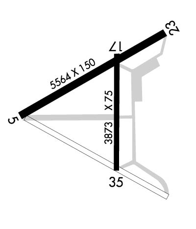
| Lat: N 3256.2 Long: W 11125.6 Elev: 1576 Var: -12 Longest Runway: 5564 | ||
| AWOS: 119.35 CTAF: 123.07 | ||
| ||||||
| ||||||
|
| Rwy | Rwy | |||||||
| 5564x150 | 5564' | 5564x150 | 5564' | |||||
| 3873x75 | 3873' | 3873x75 | 3873' | |||||
| Runway ID | Single Wheel | Double Wheel | Double Tandem Wheel | Dual Double Wheel |
| 05/23 | 80,000 | 115,000 | 210,000 | N/A |
| 17/35 | 17,000 | N/A | N/A | N/A |
| These numbers are Advisory and are not limits. The Airport Manager should have more accurate Weight Limits | ||||
 Airport Diagram might not be current. | |
| Facility Name: | COOLIDGE MUNI |
| City Name: | COOLIDGE |
| County: | PINAL |
| State abbrev: | AZ |
| State Name: | ARIZONA |
| Ownership: | PUBLICLY OWNED |
| Use: | OPEN TO THE PUBLIC |
| Owner's Name: | CITY OF COOLIDGE |
| Address: | 131 WEST PINKLEY |
| COOLIDGE, AZ 85128 | |
| Owner's Phone: | 520-723-6075 |
| Manager's Name: | JAMES MYERS |
| Address: | CITY OF COOLIDGE MUNI ARPT, 131 WEST PINKLEY |
| COOLIDGE, AZ 85128 | |
| Phone: | (520) 723-6075 |
| FAA Region: | WESTERN-PACIFIC |
| FAA Field Office: | PHX |
| Date | Sunrise | Sunset |
|---|---|---|
| 09/24/21 Friday | 6:15 | 18:20 |
| 09/25/21 Saturday | 6:16 | 18:19 |
| 09/26/21 Sunday | 6:16 | 18:17 |
| 09/27/21 Monday | 6:17 | 18:16 |
| 09/28/21 Tuesday | 6:18 | 18:14 |
| 09/29/21 Wednesday | 6:18 | 18:13 |
| 09/30/21 Thursday | 6:19 | 18:12 |
| 10/01/21 Friday | 6:20 | 18:10 |
| 10/02/21 Saturday | 6:20 | 18:09 |
| 10/03/21 Sunday | 6:21 | 18:08 |
| 10/04/21 Monday | 6:22 | 18:07 |
| 10/05/21 Tuesday | 6:23 | 18:05 |
| 10/06/21 Wednesday | 6:23 | 18:04 |
| 10/07/21 Thursday | 6:24 | 18:03 |
| Airport Attendance Schedule | MON-FRI 0800-1700 |
| Airport Status | OPERATIONAL (This Status can change at any time - please check NOTAMS) |
| Airport Lighting Schedule | DUSK-DAWN, ACTVT MIRL RWY 05/23 & MIRL RWY 17/35 - CTAF. RWY 05/23 PAPI AND REILS OPER 24 HRS. |
| Airport Storage Available | Tie Downs |
| Extra Services Available | NONE |
| Wind Indicator | YES - (unlit) |
| Control Tower | NO |
| CTAF Frequency | 123.075 |
| Unicom Frequency | 123.075 |
| Rotating Beacon Color | CLEAR-GREEN (Light Land Airport) |
| Segmented Circle | YES |
| Landing Fee | NO |
| Airport Inspected | STATE - performed by PRIVATE CONTRACT PERSONNEL |
| Inspection Date | 04/02/2020 |
| Type of Fuel Available | Grade 100LL, JET A (freeze point -40C); -10SELF FUELING WITH CREDIT CARD |
| Airframe Repair Service | None |
| Power Plant Repair Service | None |
| Latitude | N3256.2 |
| Longitude | W11125.6 (ESTIMATED) |
| Arpt Elevation | 1576ft (SURVEYED) |
| Magnetic Variation | 12E |
| 5 miles SE | of COOLIDGE |
| Traffic Pattern Altitude | |
| Sectional Chart | PHOENIX |
| Operations (Reported) | Yearly | Avg. Daily |
|---|---|---|
| General Aviation Transient | 20000 | 55 |
| General Aviation Local | 36000 | 99 |
| Air Taxi | 0 | 0 |
| Commerical | 0 | 0 |
| Commuter | 0 | 0 |
| Military | 50 | 0 |
| Aircraft based on Field | |
|---|---|
| General Aviation Singles | 24 |
| General Aviation Multi | 10 |
| Jet Aircraft | 0 |
| General Aviation Helicopters | 2 |
| Military Aircraft | 0 |
| Gliders | 0 |
| Ultralights | 1 |
| FSS on field | NO |
| FSS tie-in | PRESCOTT |
| FSS Phone | 1-800-WX-BRIEF |
| Who issues Notams | PRC |
| Notam D service at airport | YES |
| ARTCC Name | ALBUQUERQUE |
| Airport Certification | |
| Aircraft Rescue & Firefighting Index | None |
| Airport of Entry | No |
| Custom Landing Rights | No |
| Joint Civil/Military | No |
| Military Landing rights | YES |
| NATIONAL PLAN OF INTEGRATED AIRPORT SYSTEMS (NPIAS) |
| GRANT AGREEMENTS UNDER FAAP/ADAP/AIP |
| SURPLUS PROPERTY AGREEMENT UNDER PUBLIC LAW 289 |
| CONVEYANCE UNDER SCETION 16, FEDERAL AIRPORT ACT OF 1946 OR SECTION 23, AIRPORT AND AIRWAY DEVELOPMENT ACT OF 1970 |
| ASSURANCES PURSUANT TO TITLE VI, CIVIL RIGHTS ACT OF 1964 |
| FOR CD CTC ALBUQUERQUE ARTCC AT 505-856-4861. |
| LARGE MILITARY TRANSPORTS INVOF ARPT. |
| PARACHUTE JUMP TRAINING ON ARPT. DROP ZONE LCTD ESE RWY 35. |
| AEROBATIC BOX LOCATED .5 NM EAST OF ARPT SFC TO 4500 FT AGL. |
| LIVESTOCK ON AND INVOF ARPT. |
| AIRPORT ADDRESS: 3546 HANGAR DRIVE COOLIDGE AZ 85128 |
| AZARNG IS CONTACT FAC, 138.15, WHEN WORKING INSIDE OF R2310 RESTRICTED AREAS. |
| RWY 05/2 3 RWY 05/23 HAS 25 FT PAVED SHOULDERS EACH SIDE |
Airport Communications & Frequencies:
| |||||||||
| Runway: 05 | Runway: 23 | ||
| Mag heading: | 48° | Mag heading: | 228° |
| Rwy Slope: | .48% Up | Rwy Slope: | -.48% Down |
| Approach: | Approach: | ||
| Pattern: | Left Traffic | Pattern: | Right Traffic |
| Markings: | NONPRECISION INSTRUMENT | Markings: | NONPRECISION INSTRUMENT |
| Marking Condition: | GOOD | Marking Condition: | GOOD |
| Arresting Dev: | Arresting Dev: | ||
| Lat & Long: | N3256.0 W11126.1 | Lat. & Long.: | N3256.5 W11125.2 |
| Elev: | 1549.4 ft. MSL | Elev: | 1576.0 ft. MSL |
| TCH: | 45 ft. AGL | TCH: | 53 ft. AGL |
| Visual Glide Path: | 3.00 degrees | Visual Glide Path: | 3.00 degrees |
| Displaced Threshold: | No | Displaced Threshold: | No |
| Touchdown Zone: | YES | Touchdown Zone: | YES |
| Touchdown Elev.: | 1564.4 feet | Touchdown Elev.: | 1576.1 feet |
| Visual Glide Slope: | 2-Light PAPI on LEFT side of Runway | Visual Glide Slope: | 2-Light PAPI on LEFT side of Runway |
| RVR Equipment: | RVR Equipment: | ||
| RVV Equipment: | NO | RVV Equipment: | NO |
| Approach Lights: | Approach Lights: | ||
| REIL: | YES | REIL: | YES |
| Centerline Lights: | NO | Centerline Lights: | NO |
| Touchdown lights: | NO | Touchdown lights: | NO |
| Runway Category: | Runway with a Non-precision Approach having visibility minimums greater than 3/4 mile | Runway Category: | Runway with a Visual Approach |
| Declared Distances: | Declared Distances: |
| Runway: 17 | Runway: 35 | ||
| Mag heading: | 168° | Mag heading: | 348° |
| Rwy Slope: | .20% Up | Rwy Slope: | -.20% Down |
| Approach: | Approach: | ||
| Pattern: | Right Traffic | Pattern: | Left Traffic |
| Markings: | BASIC | Markings: | BASIC |
| Marking Condition: | POOR | Marking Condition: | POOR |
| Arresting Dev: | Arresting Dev: | ||
| Lat & Long: | N3256.4 W11125.5 | Lat. & Long.: | N3255.7 W11125.5 |
| Elev: | 1567.3 ft. MSL | Elev: | 1575.2 ft. MSL |
| TCH: | TCH: | ||
| Visual Glide Path: | Visual Glide Path: | ||
| Displaced Threshold: | No | Displaced Threshold: | No |
| Touchdown Zone: | YES | Touchdown Zone: | YES |
| Touchdown Elev.: | 1572.6 feet | Touchdown Elev.: | 1575.3 feet |
| Visual Glide Slope: | Visual Glide Slope: | ||
| RVR Equipment: | RVR Equipment: | ||
| RVV Equipment: | NO | RVV Equipment: | NO |
| Approach Lights: | Approach Lights: | ||
| REIL: | NO | REIL: | NO |
| Centerline Lights: | NO | Centerline Lights: | NO |
| Touchdown lights: | NO | Touchdown lights: | NO |
| Runway Category: | Runway with a Visual Approach | Runway Category: | Runway with a Visual Approach |
| Declared Distances: | Declared Distances: | ||
| Obstructions: | BRUSH | Obstructions: | |
| Marked: | NOT Marked/Lighted | Marked: | |
| Clearance slope: | 10:1 | Clearance slope: | 20:1 |
| Obstruction height: | 12 feet AGL | Obstruction height: | |
| Dist. from runway: | 327 feet | Dist. from runway: | |
| Centerline offset: | 75 right of centerline | Centerline offset: | |
| Comments: | Comments: |
Thanks for using FltPlan.com
all rights reserved © 1999-2021 by Flight Plan LLC
