
| ORANGE CITY MUNI ORANGE CITY IA |
| |
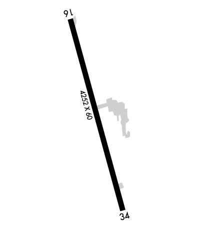
| Lat: N 4259.3 Long: W 09603.8 Elev: 1416 Var: -02 Longest Runway: 4252 | ||
| AWOS: 127.82 CTAF: 122.8 | ||
| ||||||||||||||||||||||||||||||||
| ||||||||||||||||||||||||||||||||
| ||||||||||||||||||||||||||||||||
| ||||||||||||||||||||||||||||||||
| Rwy | Rwy | |||||||
| 4252x60 | 4252' | 4252x60 | 4252' | |||||
| Runway ID | Single Wheel | Double Wheel | Double Tandem Wheel | Dual Double Wheel |
| 16/34 | 28,000 | 48,000 | N/A | N/A |
| These numbers are Advisory and are not limits. The Airport Manager should have more accurate Weight Limits | ||||
| FltPlan does not have IFR approach charts available for KORC. |
 Airport Diagram might not be current. | |
| Facility Name: | ORANGE CITY MUNI |
| City Name: | ORANGE CITY |
| County: | SIOUX |
| State abbrev: | IA |
| State Name: | IOWA |
| Ownership: | PUBLICLY OWNED |
| Use: | OPEN TO THE PUBLIC |
| Owner's Name: | CITY OF ORANGE CITY |
| Address: | 125 CENTRAL AVE SE |
| ORANGE CITY, IA 51041 | |
| Owner's Phone: | 712-707-4885 |
| Manager's Name: | CITY ADMINISTRATOR; DUANE FEEKES; DITJ MANAGER; (712) 707-4885. |
| Address: | RT 2 |
| ORANGE CITY, IA 51041 | |
| Phone: | 712-707-4885 |
| FAA Region: | CENTRAL |
| FAA Field Office: | NONE |
| Date | Sunrise | Sunset |
|---|---|---|
| 10/17/20 Saturday | 7:41 | 18:37 |
| 10/18/20 Sunday | 7:42 | 18:35 |
| 10/19/20 Monday | 7:44 | 18:34 |
| 10/20/20 Tuesday | 7:45 | 18:32 |
| 10/21/20 Wednesday | 7:46 | 18:31 |
| 10/22/20 Thursday | 7:47 | 18:29 |
| 10/23/20 Friday | 7:48 | 18:28 |
| 10/24/20 Saturday | 7:50 | 18:26 |
| 10/25/20 Sunday | 7:51 | 18:25 |
| 10/26/20 Monday | 7:52 | 18:23 |
| 10/27/20 Tuesday | 7:53 | 18:22 |
| 10/28/20 Wednesday | 7:55 | 18:21 |
| 10/29/20 Thursday | 7:56 | 18:19 |
| 10/30/20 Friday | 7:57 | 18:18 |
| Airport Attendance Schedule | 7 Days A Week 0800-1700 |
| Airport Status | CLOSED PERMANENTLY (This Status can change at any time - please check NOTAMS) |
| Airport Lighting Schedule | ACTVT MIRL RY 16/34; VASI & REIL RYS 16 & 34 - CTAF. |
| Airport Storage Available | Tie Downs, Hanger |
| Extra Services Available | Charter, Flight Instruction, Aircraft Rental |
| Wind Indicator | YES - (lighted) |
| Control Tower | NO |
| CTAF Frequency | 122.800 |
| Unicom Frequency | 122.800 |
| Rotating Beacon Color | CLEAR-GREEN (Light Land Airport); ROTG BCN OTS INDEFLY. |
| Segmented Circle | NO |
| Landing Fee | NO |
| Airport Inspected | STATE - performed by STATE AERONAUTICAL PERSONNEL |
| Inspection Date | 08/22/2018 |
| Type of Fuel Available | Grade 100LL, JET A (freeze point -40C) |
| Airframe Repair Service | None |
| Power Plant Repair Service | None |
| Latitude | N4259.3 |
| Longitude | W09603.8 (ESTIMATED) |
| Arpt Elevation | 1415ft (SURVEYED) |
| Magnetic Variation | 02E |
| 1 miles S | of ORANGE CITY |
| Traffic Pattern Altitude | |
| Sectional Chart | OMAHA |
| Operations (Reported) | Yearly | Avg. Daily |
|---|---|---|
| General Aviation Transient | 2387 | 7 |
| General Aviation Local | 1813 | 5 |
| Air Taxi | 0 | 0 |
| Commerical | 0 | 0 |
| Commuter | 0 | 0 |
| Military | 0 | 0 |
| Aircraft based on Field | |
|---|---|
| General Aviation Singles | 0 |
| General Aviation Multi | 0 |
| Jet Aircraft | 0 |
| General Aviation Helicopters | 0 |
| Military Aircraft | 0 |
| Gliders | 0 |
| Ultralights | 0 |
| FSS on field | NO |
| FSS tie-in | FORT DODGE |
| FSS Phone | 1-800-WX-BRIEF |
| Who issues Notams | ORC |
| Notam D service at airport | YES |
| ARTCC Name | MINNEAPOLIS |
| Airport Certification | |
| Aircraft Rescue & Firefighting Index | None |
| Airport of Entry | No |
| Custom Landing Rights | No |
| Joint Civil/Military | No |
| Military Landing rights | YES |
| NATIONAL PLAN OF INTEGRATED AIRPORT SYSTEMS (NPIAS) |
| ASSURANCES PURSUANT TO TITLE VI, CIVIL RIGHTS ACT OF 1964 |
| GRANT AGREEMENT HAS EXPIRED; HOWEVER, AGREEMENT REMAINS IN EFFECT FOR THIS FACILITY AS LONG AS IT IS PUBLIC USE. |
| FOR CD CTC MINNEAPOLIS ARTCC AT 651-463-5588. |
| (ARPT STATUS) ARPT CLSD PERMLY. |
Airport Communications & Frequencies:
| |||||||||
| Runway: 16 | Runway: 34 | ||
| Mag heading: | 163° | Mag heading: | 343° |
| Rwy Slope: | -.77% Down | Rwy Slope: | .77% Up |
| Approach: | Approach: | ||
| Pattern: | Left Traffic | Pattern: | Left Traffic |
| Markings: | NONPRECISION INSTRUMENT | Markings: | NONPRECISION INSTRUMENT |
| Marking Condition: | FAIR | Marking Condition: | FAIR |
| Arresting Dev: | Arresting Dev: | ||
| Lat & Long: | N4259.7 W09603.9 | Lat. & Long.: | N4259.0 W09603.6 |
| Elev: | 1415.8 ft. MSL | Elev: | 1382.9 ft. MSL |
| TCH: | 35 ft. AGL | TCH: | 44 ft. AGL |
| Visual Glide Path: | 3.50 degrees | Visual Glide Path: | 3.50 degrees |
| Displaced Threshold: | No | Displaced Threshold: | No |
| Touchdown Zone: | YES | Touchdown Zone: | YES |
| Touchdown Elev.: | 1415.8 feet | Touchdown Elev.: | 1409.5 feet |
| Visual Glide Slope: | 2-Box VASI on LEFT side of Runway | Visual Glide Slope: | 2-Box VASI on LEFT side of Runway |
| RVR Equipment: | RVR Equipment: | ||
| RVV Equipment: | NO | RVV Equipment: | NO |
| Approach Lights: | Approach Lights: | ||
| REIL: | YES | REIL: | YES |
| Centerline Lights: | NO | Centerline Lights: | NO |
| Touchdown lights: | NO | Touchdown lights: | NO |
| Runway Category: | Runway with a Visual Approach | Runway Category: | Runway with a Non-precision Approach having visibility minimums greater than 3/4 mile |
| Declared Distances: | Declared Distances: | ||
| Obstructions: | TREE | Obstructions: | ROAD |
| Marked: | NOT Marked/Lighted | Marked: | NOT Marked/Lighted |
| Clearance slope: | 18:1 | Clearance slope: | 10:1 |
| Obstruction height: | 60 feet AGL | Obstruction height: | 19 feet AGL |
| Dist. from runway: | 1281 feet | Dist. from runway: | 392 feet |
| Centerline offset: | 85 left of centerline | Centerline offset: | |
| Comments: | Comments: |
Thanks for using FltPlan.com
all rights reserved © 1999-2020 by Flight Plan LLC
