
| ORANGEBURG MUNI ORANGEBURG SC |
| |
| Lat: N 3327.4 Long: W 08051.6 Elev: 195 Var: +07 Longest Runway: 5399 | ||
| AWOS: 118.52 CTAF: 122.7 | ||
| ||||||||||||||||||||||||||||||||||||||||||||
| ||||||||||||||||||||||||||||||||||||||||||||
| ||||||||||||||||||||||||||||||||||||||||||||
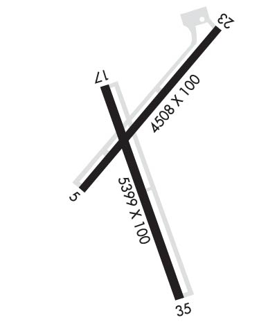
| Rwy | Rwy | |||||||
| 4508x100 | 4508' | 4508x100 | 4508' | |||||
| 5399x100 | 5399' | 5399x100 | 5399' | |||||
| Runway ID | Single Wheel | Double Wheel | Double Tandem Wheel | Dual Double Wheel |
| 05/23 | 30,000 | 50,000 | N/A | N/A |
| 17/35 | 30,000 | 72,000 | N/A | N/A |
| These numbers are Advisory and are not limits. The Airport Manager should have more accurate Weight Limits | ||||
 Airport Diagram might not be current. | |
| Facility Name: | ORANGEBURG MUNI |
| City Name: | ORANGEBURG |
| County: | ORANGEBURG |
| State abbrev: | SC |
| State Name: | SOUTH CAROLINA |
| Ownership: | PUBLICLY OWNED |
| Use: | OPEN TO THE PUBLIC |
| Owner's Name: | CITY OF ORANGEBURG |
| Address: | PO BOX 387 |
| ORANGEBURG, SC 29115 | |
| Owner's Phone: | (803) 533-6010 |
| Manager's Name: | BETTY BAKER |
| Address: | 1811 AIRPORT ROAD |
| ORANGEBURG, SC 29115 | |
| Phone: | 803-534-5545 |
| FAA Region: | SOUTHERN |
| FAA Field Office: | ATL |

| Date | Sunrise | Sunset |
|---|---|---|
| 09/24/21 Friday | 7:13 | 19:18 |
| 09/25/21 Saturday | 7:13 | 19:16 |
| 09/26/21 Sunday | 7:14 | 19:15 |
| 09/27/21 Monday | 7:15 | 19:14 |
| 09/28/21 Tuesday | 7:15 | 19:12 |
| 09/29/21 Wednesday | 7:16 | 19:11 |
| 09/30/21 Thursday | 7:17 | 19:10 |
| 10/01/21 Friday | 7:18 | 19:08 |
| 10/02/21 Saturday | 7:18 | 19:07 |
| 10/03/21 Sunday | 7:19 | 19:06 |
| 10/04/21 Monday | 7:20 | 19:04 |
| 10/05/21 Tuesday | 7:20 | 19:03 |
| 10/06/21 Wednesday | 7:21 | 19:02 |
| 10/07/21 Thursday | 7:22 | 19:00 |
| Airport Attendance Schedule | MON-FRI 0700-1700, SAT 0800-1600; NOT MANNED ON SUNDAY - FOR ASST PHONE AMGR. |
| Airport Status | OPERATIONAL (This Status can change at any time - please check NOTAMS) |
| Airport Lighting Schedule | ACTVT ODALS RY 17/35, REIL RY 23 & RY 17/35; MIRL RY 05/23 & RY 17/35 - CTAF. PAPI RYS 17 AND 35 OPER CONT. |
| Airport Storage Available | Tie Downs |
| Extra Services Available | Avionics, Flight Instruction |
| Wind Indicator | YES - (lighted) |
| Control Tower | NO |
| CTAF Frequency | 122.700 |
| Unicom Frequency | 122.700 |
| Rotating Beacon Color | CLEAR-GREEN (Light Land Airport) |
| Segmented Circle | YES |
| Landing Fee | NO |
| Airport Inspected | STATE - performed by STATE AERONAUTICAL PERSONNEL |
| Inspection Date | 06/11/2021 |
| Type of Fuel Available | Grade 100LL, JET A (freeze point -40C) |
| Airframe Repair Service | MINOR |
| Power Plant Repair Service | MINOR |
| Latitude | N3327.4 |
| Longitude | W08051.6 (ESTIMATED) |
| Arpt Elevation | 195ft (SURVEYED) |
| Magnetic Variation | 07W |
| 2 miles S | of ORANGEBURG |
| Traffic Pattern Altitude | |
| Sectional Chart | CHARLOTTE |
| Operations (Reported) | Yearly | Avg. Daily |
|---|---|---|
| General Aviation Transient | 3584 | 10 |
| General Aviation Local | 2678 | 7 |
| Air Taxi | 197 | 1 |
| Commerical | 0 | 0 |
| Commuter | 0 | 0 |
| Military | 41 | 0 |
| Aircraft based on Field | |
|---|---|
| General Aviation Singles | 20 |
| General Aviation Multi | 8 |
| Jet Aircraft | 1 |
| General Aviation Helicopters | 0 |
| Military Aircraft | 0 |
| Gliders | 0 |
| Ultralights | 0 |
| FSS on field | NO |
| FSS tie-in | ANDERSON |
| FSS Phone | 1-800-WX-BRIEF |
| Who issues Notams | OGB |
| Notam D service at airport | YES |
| ARTCC Name | JACKSONVILLE |
| Airport Certification | |
| Aircraft Rescue & Firefighting Index | None |
| Airport of Entry | No |
| Custom Landing Rights | No |
| Joint Civil/Military | No |
| Military Landing rights | YES |
| NATIONAL PLAN OF INTEGRATED AIRPORT SYSTEMS (NPIAS) |
| GRANT AGREEMENTS UNDER FAAP/ADAP/AIP |
| SURPLUS PROPERTY AGREEMENT UNDER PUBLIC LAW 289 |
| ASSURANCES PURSUANT TO TITLE VI, CIVIL RIGHTS ACT OF 1964 |
| RY 05 HAS MKD PLINES 1000 FT FROM THLD. |
| GCO AVBL ON FREQ 125.675 MONITORED BY COLUMBIA APCH CTL. |
| FOR CD IF UNA VIA GCO CTC JACKSONVILLE ARTCC AT 904-845-1592. |
Airport Communications & Frequencies:
| |||||||||||||||||
| Runway: 05 | Runway: 23 | ||
| Mag heading: | 49° | Mag heading: | 229° |
| Rwy Slope: | .55% Up | Rwy Slope: | -.55% Down |
| Approach: | Approach: | ||
| Pattern: | Right Traffic | Pattern: | Left Traffic |
| Markings: | NONPRECISION INSTRUMENT | Markings: | NONPRECISION INSTRUMENT |
| Marking Condition: | GOOD | Marking Condition: | GOOD |
| Arresting Dev: | Arresting Dev: | ||
| Lat & Long: | N3327.4 W08051.8 | Lat. & Long.: | N3327.9 W08051.2 |
| Elev: | 170.3 ft. MSL | Elev: | 195.1 ft. MSL |
| TCH: | 21 ft. AGL | TCH: | |
| Visual Glide Path: | 3.00 degrees | Visual Glide Path: | |
| Displaced Threshold: | No | Displaced Threshold: | No |
| Touchdown Zone: | YES | Touchdown Zone: | YES |
| Touchdown Elev.: | 190.6 feet | Touchdown Elev.: | 195.4 feet |
| Visual Glide Slope: | 4-BOX VASI ON LEFT SIDE OF RUNWAY; RWY 5 VASI OTS INDEFINITELY | Visual Glide Slope: | |
| RVR Equipment: | RVR Equipment: | ||
| RVV Equipment: | NO | RVV Equipment: | NO |
| Approach Lights: | Approach Lights: | ||
| REIL: | NO | REIL: | YES |
| Centerline Lights: | NO | Centerline Lights: | NO |
| Touchdown lights: | NO | Touchdown lights: | NO |
| Runway Category: | Runway with a Non-precision Approach | Runway Category: | Runway with a Non-precision Approach |
| Declared Distances: | Declared Distances: |
| Runway: 17 | Runway: 35 | ||
| Mag heading: | 174° | Mag heading: | 354° |
| Rwy Slope: | .25% Up | Rwy Slope: | -.25% Down |
| Approach: | Approach: | ||
| Pattern: | Left Traffic | Pattern: | Left Traffic |
| Markings: | NONPRECISION INSTRUMENT | Markings: | NONPRECISION INSTRUMENT |
| Marking Condition: | GOOD | Marking Condition: | GOOD |
| Arresting Dev: | Arresting Dev: | ||
| Lat & Long: | N3327.6 W08051.7 | Lat. & Long.: | N3326.8 W08051.5 |
| Elev: | 172.7 ft. MSL | Elev: | 186.0 ft. MSL |
| TCH: | 39 ft. AGL | TCH: | 37 ft. AGL |
| Visual Glide Path: | 3.00 degrees | Visual Glide Path: | 3.00 degrees |
| Displaced Threshold: | No | Displaced Threshold: | No |
| Touchdown Zone: | YES | Touchdown Zone: | YES |
| Touchdown Elev.: | 180.8 feet | Touchdown Elev.: | 186.1 feet |
| Visual Glide Slope: | 2-Light PAPI on LEFT side of Runway | Visual Glide Slope: | 2-Light PAPI on LEFT side of Runway |
| RVR Equipment: | RVR Equipment: | ||
| RVV Equipment: | NO | RVV Equipment: | NO |
| Approach Lights: | ODALS - omnidirectional approach lighting system | Approach Lights: | ODALS - omnidirectional approach lighting system |
| REIL: | YES | REIL: | YES |
| Centerline Lights: | NO | Centerline Lights: | NO |
| Touchdown lights: | NO | Touchdown lights: | NO |
| Runway Category: | Runway with a Non-precision Approach having visibility minimums greater than 3/4 mile | Runway Category: | D |
| Declared Distances: | Declared Distances: | ||
| Obstructions: | TREE | Obstructions: | Unknown |
| Marked: | NOT Marked/Lighted | Marked: | NOT Marked/Lighted |
| Clearance slope: | 26:1 | Clearance slope: | 34:1 |
| Obstruction height: | 84 feet AGL | Obstruction height: | 0 feet AGL |
| Dist. from runway: | 2457 feet | Dist. from runway: | 0 feet |
| Centerline offset: | 287 left of centerline | Centerline offset: | |
| Comments: | Comments: |
Thanks for using FltPlan.com
all rights reserved © 1999-2021 by Flight Plan LLC