
| OKEECHOBEE COUNTY OKEECHOBEE FL |
| |
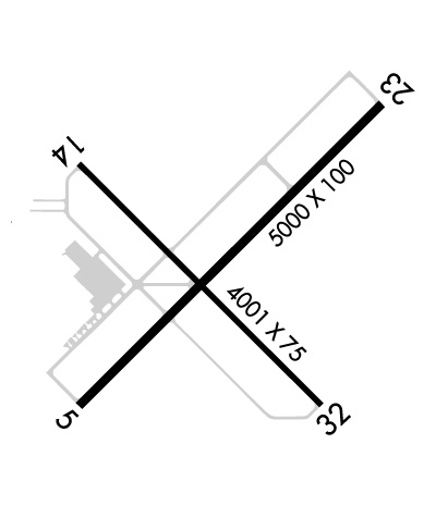
| Lat: N 2716.0 Long: W 08051.0 Elev: 34 Var: +06 Longest Runway: 5000 | ||
| AWOS: 118.67 CTAF: 123.0 | ||
| ||||||||||||||||||||||||||||||||||||||||||||
| ||||||||||||||||||||||||||||||||||||||||||||
| ||||||||||||||||||||||||||||||||||||||||||||
| Rwy | Rwy | |||||||
| 5000x100 | 5000' | 5000x100 | 5000' | |||||
| 4001x75 | 4001' | 4001x75 | 4001' | |||||
| Runway ID | Single Wheel | Double Wheel | Double Tandem Wheel | Dual Double Wheel |
| 05/23 | 40,000 | N/A | N/A | N/A |
| 14/32 | 30,000 | N/A | N/A | N/A |
| These numbers are Advisory and are not limits. The Airport Manager should have more accurate Weight Limits | ||||
 Airport Diagram might not be current. | |
| Facility Name: | OKEECHOBEE COUNTY |
| City Name: | OKEECHOBEE |
| County: | OKEECHOBEE |
| State abbrev: | FL |
| State Name: | FLORIDA |
| Ownership: | PUBLICLY OWNED |
| Use: | OPEN TO THE PUBLIC |
| Owner's Name: | OKEECHOBEE COUNTY; ROBBIE CHARTIER 863-763-6441 |
| Address: | 2800 NORTH WEST 20TH TRAIL |
| OKEECHOBEE, FL 34972 | |
| Owner's Phone: | 863-763-6441 |
| Manager's Name: | ANDREW MCBEAN |
| Address: | 2800 NW 20TH TRL |
| OKEECHOBEE, FL 34972 | |
| Phone: | 863-467-5505; EMERG - 863-634-1474 |
| FAA Region: | SOUTHERN |
| FAA Field Office: | ORL |

| Date | Sunrise | Sunset |
|---|---|---|
| 09/24/21 Friday | 7:13 | 19:18 |
| 09/25/21 Saturday | 7:13 | 19:17 |
| 09/26/21 Sunday | 7:14 | 19:16 |
| 09/27/21 Monday | 7:14 | 19:14 |
| 09/28/21 Tuesday | 7:15 | 19:13 |
| 09/29/21 Wednesday | 7:15 | 19:12 |
| 09/30/21 Thursday | 7:15 | 19:11 |
| 10/01/21 Friday | 7:16 | 19:10 |
| 10/02/21 Saturday | 7:16 | 19:09 |
| 10/03/21 Sunday | 7:17 | 19:08 |
| 10/04/21 Monday | 7:17 | 19:07 |
| 10/05/21 Tuesday | 7:18 | 19:05 |
| 10/06/21 Wednesday | 7:18 | 19:04 |
| 10/07/21 Thursday | 7:19 | 19:03 |
| Airport Attendance Schedule | 7 Days A Week 0900-1700; AFT HR - 863-634-0352. |
| Airport Status | OPERATIONAL (This Status can change at any time - please check NOTAMS) |
| Airport Lighting Schedule | ACTVT MIRL RWY 05/23 - CTAF |
| Airport Storage Available | Tie Downs |
| Extra Services Available | NONE |
| Wind Indicator | YES - (lighted) |
| Control Tower | NO |
| CTAF Frequency | 123.000 |
| Unicom Frequency | 123.000 |
| Rotating Beacon Color | CLEAR-GREEN (Light Land Airport) |
| Segmented Circle | Y-L |
| Landing Fee | NO |
| Airport Inspected | STATE - performed by STATE AERONAUTICAL PERSONNEL |
| Inspection Date | 07/27/2018 |
| Type of Fuel Available | Grade 100LL, JET A (freeze point -40C) |
| Airframe Repair Service | MAJOR |
| Power Plant Repair Service | MINOR |
| Latitude | N2716.0 |
| Longitude | W08051.0 (ESTIMATED) |
| Arpt Elevation | 33ft (SURVEYED) |
| Magnetic Variation | 06W |
| 3 miles NW | of OKEECHOBEE |
| Traffic Pattern Altitude | |
| Sectional Chart | MIAMI |
| Operations (Reported) | Yearly | Avg. Daily |
|---|---|---|
| General Aviation Transient | 45000 | 123 |
| General Aviation Local | 5000 | 14 |
| Air Taxi | 0 | 0 |
| Commerical | 0 | 0 |
| Commuter | 0 | 0 |
| Military | 0 | 0 |
| Aircraft based on Field | |
|---|---|
| General Aviation Singles | 21 |
| General Aviation Multi | 2 |
| Jet Aircraft | 1 |
| General Aviation Helicopters | 1 |
| Military Aircraft | 0 |
| Gliders | 0 |
| Ultralights | 0 |
| FSS on field | NO |
| FSS tie-in | SAINT PETERSBURG |
| FSS Phone | 1-800-WX-BRIEF |
| Who issues Notams | PIE |
| Notam D service at airport | YES |
| ARTCC Name | MIAMI |
| Airport Certification | |
| Aircraft Rescue & Firefighting Index | None |
| Airport of Entry | No |
| Custom Landing Rights | No |
| Joint Civil/Military | No |
| Military Landing rights | YES |
| NATIONAL PLAN OF INTEGRATED AIRPORT SYSTEMS (NPIAS) |
| GRANT AGREEMENTS UNDER FAAP/ADAP/AIP |
| SURPLUS PROPERTY AGREEMENT UNDER REGULATION 16-WAA |
| ASSURANCES PURSUANT TO TITLE VI, CIVIL RIGHTS ACT OF 1964 |
| AGREEMENT UNDER DLAND OR DCLA HAS EXPIRED. |
| BIRDS, CRANES & ULTRALIGHT ACT ON & INVOF ARPT. |
| FBO - 863-467-5888. |
| NON-POWERED FLT WI TFC PAT NA. |
| TKOF & LNDG ON GRASS AT OWN RISK. |
| FOR CD CTC MIAMI ARTCC AT 305-716-1731. |
| RWY 05 CALM WIND RWY. |
Airport Communications & Frequencies:
| |||||||||
| Runway: 05 | Runway: 23 | ||
| Mag heading: | 51° | Mag heading: | 231° |
| Rwy Slope: | .00% Down | Rwy Slope: | .00% Up |
| Approach: | Approach: | ||
| Pattern: | Left Traffic | Pattern: | Left Traffic |
| Markings: | NONPRECISION INSTRUMENT | Markings: | NONPRECISION INSTRUMENT |
| Marking Condition: | FAIR | Marking Condition: | FAIR |
| Arresting Dev: | Arresting Dev: | ||
| Lat & Long: | N2715.7 W08051.3 | Lat. & Long.: | N2716.3 W08050.7 |
| Elev: | 32.9 ft. MSL | Elev: | 32.8 ft. MSL |
| TCH: | 40 ft. AGL | TCH: | 40 ft. AGL |
| Visual Glide Path: | 3.00 degrees | Visual Glide Path: | 3.00 degrees |
| Displaced Threshold: | No | Displaced Threshold: | No |
| Touchdown Zone: | YES | Touchdown Zone: | YES |
| Touchdown Elev.: | 33.5 feet | Touchdown Elev.: | 33.5 feet |
| Visual Glide Slope: | 4-Light PAPI on LEFT side of Runway | Visual Glide Slope: | 4-Light PAPI on LEFT side of Runway |
| RVR Equipment: | RVR Equipment: | ||
| RVV Equipment: | NO | RVV Equipment: | NO |
| Approach Lights: | Approach Lights: | ||
| REIL: | YES | REIL: | YES |
| Centerline Lights: | NO | Centerline Lights: | NO |
| Touchdown lights: | NO | Touchdown lights: | NO |
| Runway Category: | Runway with a Non-precision Approach having visibility minimums greater than 3/4 mile | Runway Category: | Runway with a Non-precision Approach having visibility minimums greater than 3/4 mile |
| Declared Distances: | Declared Distances: | ||
| Obstructions: | TREE | Obstructions: | TREES |
| Marked: | NOT Marked/Lighted | Marked: | NOT Marked/Lighted |
| Clearance slope: | 47:1 | Clearance slope: | 28:1 |
| Obstruction height: | 40 feet AGL | Obstruction height: | 43 feet AGL |
| Dist. from runway: | 2040 feet | Dist. from runway: | 1430 feet |
| Centerline offset: | Centerline offset: | 220 feet left of centerline | |
| Comments: | Comments: |
| Runway: 14 | Runway: 32 | ||
| Mag heading: | 141° | Mag heading: | 321° |
| Rwy Slope: | -.02% Down | Rwy Slope: | .02% Up |
| Approach: | Approach: | ||
| Pattern: | Left Traffic | Pattern: | Left Traffic |
| Markings: | NONPRECISION INSTRUMENT | Markings: | NONPRECISION INSTRUMENT |
| Marking Condition: | FAIR | Marking Condition: | FAIR |
| Arresting Dev: | Arresting Dev: | ||
| Lat & Long: | N2716.2 W08051.3 | Lat. & Long.: | N2715.7 W08050.8 |
| Elev: | 33.0 ft. MSL | Elev: | 32.3 ft. MSL |
| TCH: | 40 ft. AGL | TCH: | 40 ft. AGL |
| Visual Glide Path: | 3.00 degrees | Visual Glide Path: | 3.00 degrees |
| Displaced Threshold: | No | Displaced Threshold: | No |
| Touchdown Zone: | YES | Touchdown Zone: | YES |
| Touchdown Elev.: | 33.5 feet | Touchdown Elev.: | 33.5 feet |
| Visual Glide Slope: | 4-Light PAPI on LEFT side of Runway | Visual Glide Slope: | 4-Light PAPI on LEFT side of Runway |
| RVR Equipment: | RVR Equipment: | ||
| RVV Equipment: | NO | RVV Equipment: | NO |
| Approach Lights: | Approach Lights: | ||
| REIL: | NO | REIL: | NO |
| Centerline Lights: | NO | Centerline Lights: | NO |
| Touchdown lights: | NO | Touchdown lights: | NO |
| Runway Category: | Runway with a Non-precision Approach | Runway Category: | Runway with a Non-precision Approach |
| Declared Distances: | Declared Distances: | ||
| Obstructions: | TREES | Obstructions: | FENCE |
| Marked: | NOT Marked/Lighted | Marked: | LIGHTED |
| Clearance slope: | 25:1 | Clearance slope: | |
| Obstruction height: | 34 feet AGL | Obstruction height: | 5 feet AGL |
| Dist. from runway: | 1060 feet | Dist. from runway: | 200 feet |
| Centerline offset: | 175 left of centerline | Centerline offset: | 215 feet left of centerline |
| Comments: | Comments: | 5 FT FENCE 200FT FM RWY END 215 FT L. |
Thanks for using FltPlan.com
all rights reserved © 1999-2021 by Flight Plan LLC