
| WHITING FIELD NAS NORTH MILTON FL |
| |
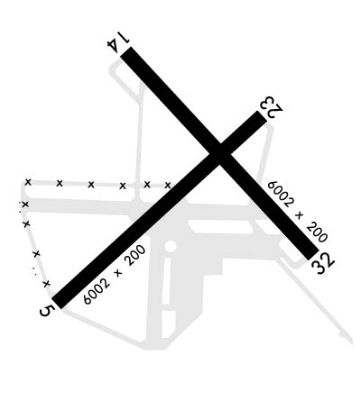
| Lat: N 3043.3 Long: W 08701.4 Elev: 199 Var: +02 Longest Runway: 6003 | ||
| Clr Del: 257.77 Dept. ATIS: 126.2 Arr. ATIS: 126.2 Ground: 251.15 Tower: 121.4 | ||
| ||||||
|
| Rwy | Rwy | |||||||
| 6003x200 | 6003' | 6003x200 | 6003' | |||||
| 6001x200 | 6001' | 111.75 - 139° | 6001x200 | 6001' | ||||
| Runway ID | Single Wheel | Double Wheel | Double Tandem Wheel | Dual Double Wheel |
| 05/23 | N/A | N/A | N/A | N/A |
| 14/32 | N/A | N/A | N/A | N/A |
| These numbers are Advisory and are not limits. The Airport Manager should have more accurate Weight Limits | ||||
 Airport Diagram might not be current. | |
| Facility Name: | WHITING FLD NAS NORTH |
| City Name: | MILTON |
| County: | SANTA ROSA |
| State abbrev: | FL |
| State Name: | FLORIDA |
| Ownership: | NAVY OWNED |
| Use: | PRIVATE |
| Owner's Name: | US NAVY |
| Address: | OCEANOGRAPHIC OFC-CODE 3142 |
| WASHINGTON, DC 20373 | |
| Owner's Phone: | |
| Manager's Name: | COMMANDING OFFICER |
| Address: | NAVAL AIR STATION WHITING FLD |
| MILTON, FL 32570 | |
| Phone: | |
| FAA Region: | SOUTHERN |
| FAA Field Office: | ORL |
| Date | Sunrise | Sunset |
|---|---|---|
| 09/24/21 Friday | 6:37 | 18:42 |
| 09/25/21 Saturday | 6:38 | 18:41 |
| 09/26/21 Sunday | 6:39 | 18:40 |
| 09/27/21 Monday | 6:39 | 18:39 |
| 09/28/21 Tuesday | 6:40 | 18:37 |
| 09/29/21 Wednesday | 6:40 | 18:36 |
| 09/30/21 Thursday | 6:41 | 18:35 |
| 10/01/21 Friday | 6:41 | 18:34 |
| 10/02/21 Saturday | 6:42 | 18:32 |
| 10/03/21 Sunday | 6:43 | 18:31 |
| 10/04/21 Monday | 6:43 | 18:30 |
| 10/05/21 Tuesday | 6:44 | 18:29 |
| 10/06/21 Wednesday | 6:45 | 18:27 |
| 10/07/21 Thursday | 6:45 | 18:26 |
| Airport Attendance Schedule | MON-FRI 1245-0445Z++; CLSD SAT, SUN & HOL; OTR BY NOTAM. |
| Airport Status | OPERATIONAL (This Status can change at any time - please check NOTAMS) |
| Airport Lighting Schedule | AVBL DURG OPS HRS. |
| Airport Storage Available | NONE |
| Extra Services Available | NONE |
| Wind Indicator | NONE |
| Control Tower | YES |
| CTAF Frequency | |
| Unicom Frequency | |
| Rotating Beacon Color | SPLIT-CLEAR-GREEN (LIGHTED MILITARY AIRPORT) |
| Segmented Circle | NO |
| Landing Fee |
| Airport Inspected | No Inspection Data Available performed by the OWNER |
| Inspection Date | Unknown |
| Type of Fuel Available | Grade 100LL |
| Airframe Repair Service | NONE |
| Power Plant Repair Service | NONE |
| Latitude | N3043.3 |
| Longitude | W08701.4 (ESTIMATED) |
| Arpt Elevation | 199ft (ESTIMATED) |
| Magnetic Variation | 02W |
| 4 miles N | of MILTON |
| Traffic Pattern Altitude | |
| Sectional Chart | NEW ORLEANS |
| Operations (Reported) | Yearly | Avg. Daily |
|---|---|---|
| General Aviation Transient | 0 | 0 |
| General Aviation Local | 0 | 0 |
| Air Taxi | 0 | 0 |
| Commerical | 0 | 0 |
| Commuter | 0 | 0 |
| Military | 0 | 0 |
| Aircraft based on Field | |
|---|---|
| General Aviation Singles | 0 |
| General Aviation Multi | 0 |
| Jet Aircraft | 0 |
| General Aviation Helicopters | 0 |
| Military Aircraft | 0 |
| Gliders | 0 |
| Ultralights | 0 |
| FSS on field | NO |
| FSS tie-in | GAINESVILLE; NOTAM PNS. |
| FSS Phone | 1-800-WX-BRIEF |
| Who issues Notams | NSE |
| Notam D service at airport | YES |
| ARTCC Name | JACKSONVILLE |
| Airport Certification | |
| Aircraft Rescue & Firefighting Index | None |
| Airport of Entry | No |
| Custom Landing Rights | No |
| Joint Civil/Military | No |
| Military Landing rights | No |
| RSTD: PPR FOR TSNT PRAC APCH & LDG; LTD TSNT PRK & SVC AVBL - DUTY OPS DSN 868-7475, C850-623-7475 & CALP OR E-MAIL: WHTG_NASWF_AIROPS_AFM@NAVY.MIL. WHITING FLD S UNLESS OTHERWISE ARNG WITH OPS OFFICER. (SEE WHITING FLD NAS-S) 24 HR PPR. |
| CTN: TRNG OPS INVOF ALL HRS; PONDING OCRS AFT RAIN - BRAP. |
| SERVICE-JASU-1(NC-8) FUEL - F24 TRAN ALERT. LTD TRAN LINE SVC AVBL 1400-220Z++ MON-FRI ONLY. |
| TWY Z & 200 FT INWARD FM COMPASS ROSE OF TWY A NOT VSB FM ATCT. |
| DD-1801 WX CODES OBTAINED AT HTTPS:/FWB.METOC.NAVY.MIL. METOC AFT HR - AWS/NORFOLK 1-888-745-6899. |
| SMT WHITING FLD FP - FAX C850-623-7356 OR WHTG_NASWF_BASEOPS.FCT@NAVY.MIL; CFM FP - FPG DISPATCH D868-7598/7597/7654 OR C850-623-7598/7597/7654. |
Airport Communications & Frequencies:
| ||||||||||||||||||||||||||||||||||||
| Runway: 05 | Runway: 23 | ||
| Mag heading: | 49° | Mag heading: | 229° |
| Rwy Slope: | .22% Up | Rwy Slope: | -.22% Down |
| Approach: | Approach: | ||
| Pattern: | Left Traffic | Pattern: | Left Traffic |
| Markings: | Markings: | ||
| Marking Condition: | FAIR | Marking Condition: | FAIR |
| Arresting Dev: | Arresting Dev: | ||
| Lat & Long: | N3042.9 W08702.0 | Lat. & Long.: | N3043.6 W08701.1 |
| Elev: | 169.3 ft. MSL | Elev: | 182.6 ft. MSL |
| TCH: | 60 ft. AGL | TCH: | 52 ft. AGL |
| Visual Glide Path: | 3.00 degrees | Visual Glide Path: | 3.00 degrees |
| Displaced Threshold: | No | Displaced Threshold: | No |
| Touchdown Zone: | YES | Touchdown Zone: | YES |
| Touchdown Elev.: | 179.7 feet | Touchdown Elev.: | 183.0 feet |
| Visual Glide Slope: | 4-Light PAPI on LEFT side of Runway | Visual Glide Slope: | 4-Light PAPI on LEFT side of Runway |
| RVR Equipment: | RVR Equipment: | ||
| RVV Equipment: | NO | RVV Equipment: | NO |
| Approach Lights: | Approach Lights: | ||
| REIL: | NO | REIL: | NO |
| Centerline Lights: | NO | Centerline Lights: | NO |
| Touchdown lights: | NO | Touchdown lights: | NO |
| Runway Category: | Runway Category: | ||
| Declared Distances: | Declared Distances: |
| Runway: 14 | Runway: 32 | ||
| Mag heading: | 139° | Mag heading: | 319° |
| Rwy Slope: | -.66% Down | Rwy Slope: | .66% Up |
| Approach: | ILS/DME | Approach: | |
| Pattern: | Left Traffic | Pattern: | Left Traffic |
| Markings: | Markings: | ||
| Marking Condition: | FAIR | Marking Condition: | FAIR |
| Arresting Dev: | Arresting Dev: | ||
| Lat & Long: | N3043.8 W08701.7 | Lat. & Long.: | N3043.1 W08700.9 |
| Elev: | 198.8 ft. MSL | Elev: | 159.1 ft. MSL |
| TCH: | 51 ft. AGL | TCH: | 53 ft. AGL |
| Visual Glide Path: | 3.00 degrees | Visual Glide Path: | 3.00 degrees |
| Displaced Threshold: | No | Displaced Threshold: | No |
| Touchdown Zone: | YES | Touchdown Zone: | YES |
| Touchdown Elev.: | 198.8 feet | Touchdown Elev.: | 181.1 feet |
| Visual Glide Slope: | 4-Light PAPI on LEFT side of Runway | Visual Glide Slope: | 4-Light PAPI on LEFT side of Runway |
| RVR Equipment: | RVR Equipment: | ||
| RVV Equipment: | NO | RVV Equipment: | NO |
| Approach Lights: | MALSR - 1,400 foot medium intensity approach lighting system with runway alignment indicator lights | Approach Lights: | |
| REIL: | NO | REIL: | NO |
| Centerline Lights: | NO | Centerline Lights: | NO |
| Touchdown lights: | NO | Touchdown lights: | NO |
| Runway Category: | Runway Category: | ||
| Declared Distances: | Declared Distances: |
Thanks for using FltPlan.com
all rights reserved © 1999-2021 by Flight Plan LLC
