
| STROUDSBURG-POCONO (CLOSED) EAST STROUDSBURG PA |
| |
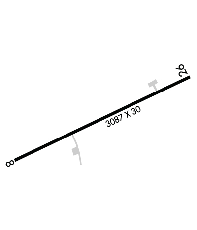
| Lat: N 4102.2 Long: W 07509.6 Elev: 480 Var: +11 Longest Runway: 3087 | ||
| CTAF: 123.0 | ||
| ||||||||||||||||||||||||||||||||
| ||||||||||||||||||||||||||||||||
| Rwy | Rwy | |||||||
| 3087x30 | 2987' | 3087x30 | 2317' | |||||
| Runway ID | Single Wheel | Double Wheel | Double Tandem Wheel | Dual Double Wheel |
| 08/26 | N/A | N/A | N/A | N/A |
| These numbers are Advisory and are not limits. The Airport Manager should have more accurate Weight Limits | ||||
| FltPlan does not have IFR approach charts available for KN53. |
 Airport Diagram might not be current. | |
| Facility Name: | STROUDSBURG-POCONO |
| City Name: | EAST STROUDSBURG |
| County: | MONROE |
| State abbrev: | PA |
| State Name: | PENNSYLVANIA |
| Ownership: | PRIVATELY OWNED |
| Use: | OPEN TO THE PUBLIC |
| Owner's Name: | BLACK BUFFALO LAND ACQUISITION, LLC |
| Address: | BIG SUN HOLDINGS GROUP, INC.,, 3 EAST 28TH ST, 12TH FLOOR |
| NEW YORK, NY 10016 | |
| Owner's Phone: | 646-650-5863 |
| Manager's Name: | MICHAEL WOODS |
| Address: | BIG SUN HOLDINGS GROUP, INC, 3 EAST 28TH ST, 12TH FLOOR |
| NEW YORK, NY 10016 | |
| Phone: | 646-650-5863 |
| FAA Region: | EASTERN |
| FAA Field Office: | HAR |
| Date | Sunrise | Sunset |
|---|---|---|
| 06/06/23 Tuesday | 5:29 | 20:30 |
| 06/07/23 Wednesday | 5:29 | 20:30 |
| 06/08/23 Thursday | 5:28 | 20:31 |
| 06/09/23 Friday | 5:28 | 20:32 |
| 06/10/23 Saturday | 5:28 | 20:32 |
| 06/11/23 Sunday | 5:28 | 20:33 |
| 06/12/23 Monday | 5:28 | 20:33 |
| 06/13/23 Tuesday | 5:28 | 20:34 |
| 06/14/23 Wednesday | 5:28 | 20:34 |
| 06/15/23 Thursday | 5:28 | 20:35 |
| 06/16/23 Friday | 5:28 | 20:35 |
| 06/17/23 Saturday | 5:28 | 20:35 |
| 06/18/23 Sunday | 5:28 | 20:36 |
| 06/19/23 Monday | 5:28 | 20:36 |
| Airport Attendance Schedule | UNATTENDED; FOR SVC CTC (578) 476-7606. |
| Airport Status | CLOSED INDEFINITELY (This Status can change at any time - please check NOTAMS) |
| Airport Lighting Schedule | ACTVT LIRL RWY 08/26 - CTAF.; ACTVT ROTG BCN - CTAF. |
| Airport Storage Available | Tie Downs, Hanger |
| Extra Services Available | Air Ambulance, Parachute Jumping |
| Wind Indicator | YES - (unlit) |
| Control Tower | NO |
| CTAF Frequency | 123.000 |
| Unicom Frequency | 123.000 |
| Rotating Beacon Color | WG |
| Segmented Circle | YES |
| Landing Fee | NO |
| Airport Inspected | STATE - performed by STATE AERONAUTICAL PERSONNEL |
| Inspection Date | 04/20/2021 |
| Type of Fuel Available | Grade 100LL; -10100LL SELF SERVE WITH CREDIT CARD. |
| Airframe Repair Service | NONE |
| Power Plant Repair Service | NONE |
| Latitude | N4102.2 |
| Longitude | W07509.6 (ESTIMATED) |
| Arpt Elevation | 480ft (ESTIMATED) |
| Magnetic Variation | 11W |
| 3 miles N | of EAST STROUDSBURG |
| Traffic Pattern Altitude | |
| Sectional Chart | NEW YORK |
| Operations (Reported) | Yearly | Avg. Daily |
|---|---|---|
| General Aviation Transient | 1000 | 3 |
| General Aviation Local | 5000 | 14 |
| Air Taxi | 0 | 0 |
| Commerical | 0 | 0 |
| Commuter | 0 | 0 |
| Military | 20 | 0 |
| Aircraft based on Field | |
|---|---|
| General Aviation Singles | 5 |
| General Aviation Multi | 1 |
| Jet Aircraft | 0 |
| General Aviation Helicopters | 1 |
| Military Aircraft | 0 |
| Gliders | 0 |
| Ultralights | 0 |
| FSS on field | NO |
| FSS tie-in | WILLIAMSPORT |
| FSS Phone | 1-800-WX-BRIEF |
| Who issues Notams | IPT |
| Notam D service at airport | YES |
| ARTCC Name | NEW YORK |
| Airport Certification | |
| Aircraft Rescue & Firefighting Index | None |
| Airport of Entry | No |
| Custom Landing Rights | No |
| Joint Civil/Military | No |
| Military Landing rights | No |
| THIS AIRPORT HAS BEEN SURVEYED BY THE NATIONAL GEODETIC SURVEY. |
| ULTRALIGHTS ON & INVOF ARPT. |
| DEER ON & INVOF ARPT. |
| RWY LGTS OTS. |
| FOR CD CTC ALLENTOWN APCH AT 800-728-6322. |
| RWY CLSD FOR NIGHT OPS |
| (ARPT STATUS) ARPT CLSD INDEFLY. |
| RWY 08/2 6 CRACKING IN PAVEMENT, SPALLING, HEAVING. |
| RWY 08/2 6 NSTD LIRL; RWY 26 END LGT OFFSET FROM RWY CTNRLN. |
Airport Communications & Frequencies:
| ||||||||||||||||||
| Runway: 08 | Runway: 26 | ||
| Mag heading: | 77° | Mag heading: | 257° |
| Rwy Slope: | .29% Up | Rwy Slope: | -.29% Down |
| Approach: | Approach: | ||
| Pattern: | Left Traffic | Pattern: | Left Traffic |
| Markings: | NONPRECISION INSTRUMENT | Markings: | NONPRECISION INSTRUMENT |
| Marking Condition: | FAIR | Marking Condition: | FAIR; NO MARKINGS/ARROWS TO 770 FT DISPL THLD. |
| Arresting Dev: | Arresting Dev: | ||
| Lat & Long: | N4102.1 W07509.9 | Lat. & Long.: | N4102.3 W07509.3 |
| Elev: | 471.0 ft. MSL | Elev: | 480.0 ft. MSL |
| TCH: | TCH: | ||
| Visual Glide Path: | Visual Glide Path: | ||
| Displaced Threshold: | 100 feet | Displaced Threshold: | 770 feet |
| Touchdown Zone: | YES | Touchdown Zone: | YES |
| Touchdown Elev.: | 480.0 feet | Touchdown Elev.: | 480.0 feet |
| Visual Glide Slope: | Visual Glide Slope: | ||
| RVR Equipment: | RVR Equipment: | ||
| RVV Equipment: | NO | RVV Equipment: | NO |
| Approach Lights: | Approach Lights: | ||
| REIL: | NO | REIL: | NO |
| Centerline Lights: | NO | Centerline Lights: | NO |
| Touchdown lights: | NO | Touchdown lights: | NO |
| Runway Category: | Runway with a Visual Approach | Runway Category: | Runway with a Visual Approach |
| Declared Distances: | Declared Distances: | ||
| Obstructions: | TREES | Obstructions: | TREE |
| Marked: | NOT Marked/Lighted | Marked: | NOT Marked/Lighted |
| Clearance slope: | 6:1; APCH RATIO 16:1 TO DTHR. | Clearance slope: | 1:1; APCH RATIO 21:1 TO DTHR. |
| Obstruction height: | 29 feet AGL | Obstruction height: | 49 feet AGL |
| Dist. from runway: | 388 feet | Dist. from runway: | 285 feet |
| Centerline offset: | 75 right of centerline | Centerline offset: | 81 feet right of centerline |
| Comments: | Comments: | 15 FT ROAD 90 FT FM RWY END EXTENDING ACRS SAFETY ZONE. 26 FT BRUSH 125 FT FM RWY END, 64 FT RIGHT. |
Thanks for using FltPlan.com
all rights reserved © 1999-2023 by Flight Plan LLC
