
| LINCOLN PARK LINCOLN PARK NJ |
| |
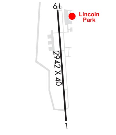
| Lat: N 4056.9 Long: W 07418.9 Elev: 181 Var: +13 Longest Runway: 2767 | ||
| CTAF: 122.8 | ||
| ||||||
|
| Rwy | Rwy | |||||||
| 2767x40 | 2077' | 2767x40 | 2672' | |||||
| Runway ID | Single Wheel | Double Wheel | Double Tandem Wheel | Dual Double Wheel |
| 01/19 | N/A | N/A | N/A | N/A |
| These numbers are Advisory and are not limits. The Airport Manager should have more accurate Weight Limits | ||||
 Airport Diagram might not be current. | |
| Facility Name: | LINCOLN PARK |
| City Name: | LINCOLN PARK |
| County: | MORRIS |
| State abbrev: | NJ |
| State Name: | NEW JERSEY |
| Ownership: | PRIVATELY OWNED |
| Use: | OPEN TO THE PUBLIC |
| Owner's Name: | LINCOLN PARK AIRPORT INC |
| Address: | 425 BEAVER BROOK ROAD |
| LINCOLN PARK, NJ 07035 | |
| Owner's Phone: | 973-628-7166 |
| Manager's Name: | TOM VAN WINGERDEN |
| Address: | 425 BEAVER BROOK ROAD |
| LINCOLN PARK, NJ 07035 | |
| Phone: | 973-628-7166 |
| FAA Region: | EASTERN |
| FAA Field Office: | HAR |
| Date | Sunrise | Sunset |
|---|---|---|
| 04/19/26 Sunday | 6:13 | 19:41 |
| 04/20/26 Monday | 6:11 | 19:42 |
| 04/21/26 Tuesday | 6:10 | 19:43 |
| 04/22/26 Wednesday | 6:08 | 19:44 |
| 04/23/26 Thursday | 6:07 | 19:45 |
| 04/24/26 Friday | 6:05 | 19:46 |
| 04/25/26 Saturday | 6:04 | 19:47 |
| 04/26/26 Sunday | 6:02 | 19:48 |
| 04/27/26 Monday | 6:01 | 19:49 |
| 04/28/26 Tuesday | 6:00 | 19:50 |
| 04/29/26 Wednesday | 5:58 | 19:52 |
| 04/30/26 Thursday | 5:57 | 19:53 |
| 05/01/26 Friday | 5:56 | 19:54 |
| 05/02/26 Saturday | 5:54 | 19:55 |
| Airport Attendance Schedule | MON-FRI 0900-DUSK, SAT-SUN UNATT |
| Airport Status | OPERATIONAL (This Status can change at any time - please check NOTAMS) |
| Airport Lighting Schedule | ACTVT HIRL RY 01/19 - CTAF. ACTVT HIGH INTST FST WITH 7 CLICKS BFR ACTVTNG LOWER INTSTS. |
| Airport Storage Available | Tie Downs |
| Extra Services Available | Charter, Flight Instruction, Aircraft Rental, Aircraft Sales |
| Wind Indicator | YES - (unlit) |
| Control Tower | NO |
| CTAF Frequency | 122.800 |
| Unicom Frequency | 122.800 |
| Rotating Beacon Color | WG |
| Segmented Circle | NO |
| Landing Fee | NO |
| Airport Inspected | STATE - performed by STATE AERONAUTICAL PERSONNEL |
| Inspection Date | 08/12/2025 |
| Type of Fuel Available | Grade 100LL, JET A (freeze point -40C) |
| Airframe Repair Service | MAJOR |
| Power Plant Repair Service | MAJOR |
| Latitude | N4056.9 |
| Longitude | W07418.9 (ESTIMATED) |
| Arpt Elevation | 181ft (SURVEYED) |
| Magnetic Variation | 13W |
| 2 miles N | of LINCOLN PARK |
| Traffic Pattern Altitude | |
| Sectional Chart | NEW YORK |
| Operations (Reported) | Yearly | Avg. Daily |
|---|---|---|
| General Aviation Transient | 0 | 0 |
| General Aviation Local | 0 | 0 |
| Air Taxi | 0 | 0 |
| Commerical | 0 | 0 |
| Commuter | 0 | 0 |
| Military | 0 | 0 |
| Aircraft based on Field | |
|---|---|
| General Aviation Singles | 0 |
| General Aviation Multi | 0 |
| Jet Aircraft | 0 |
| General Aviation Helicopters | 0 |
| Military Aircraft | 0 |
| Gliders | 0 |
| Ultralights | 0 |
| FSS on field | NO |
| FSS tie-in | MILLVILLE |
| FSS Phone | 1-800-WX-BRIEF |
| Who issues Notams | MIV |
| Notam D service at airport | YES |
| ARTCC Name | NEW YORK |
| Airport Certification | |
| Aircraft Rescue & Firefighting Index | None |
| Airport of Entry | No |
| Custom Landing Rights | No |
| Joint Civil/Military | No |
| Military Landing rights | No |
| NATIONAL PLAN OF INTEGRATED AIRPORT SYSTEMS (NPIAS) |
| GRANT AGREEMENTS UNDER FAAP/ADAP/AIP |
| ASSURANCES PURSUANT TO TITLE VI, CIVIL RIGHTS ACT OF 1964 |
| NARROW TAXILANES & TWYS CAUSED BY NSTD CLNCS. |
| DEER AND BIRDS INVOF RUNWAY. |
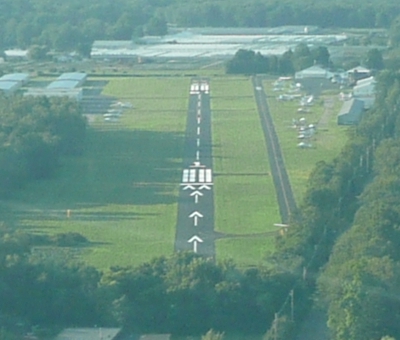
| TOUCH AND GO LANDINGS PROHIBITED. |
| GCO AVBL ON FREQ 121.725. IF UNABLE, CTC NEWARK APCH AT 800-645-3206. |
| TSNT HEL OPS ALLOWED WITH PRE-APVL ONLY, CALL 973-628-7166. |
| (CONTACT TITLE) FBO CTC (973) 633-0450. |
Airport Communications & Frequencies:
| ||||||||||||||
| Runway: 01 | Runway: 19 | ||
| Mag heading: | 8° | Mag heading: | 188° |
| Rwy Slope: | .13% Up | Rwy Slope: | -.13% Down |
| Approach: | Approach: | ||
| Pattern: | Left Traffic | Pattern: | Left Traffic |
| Markings: | NONPRECISION INSTRUMENT | Markings: | NONPRECISION INSTRUMENT |
| Marking Condition: | GOOD | Marking Condition: | GOOD |
| Arresting Dev: | Arresting Dev: | ||
| Lat & Long: | N4056.6 W07418.8 | Lat. & Long.: | N4057.1 W07418.9 |
| Elev: | 177.0 ft. MSL | Elev: | 180.6 ft. MSL |
| TCH: | TCH: | 30 ft. AGL | |
| Visual Glide Path: | Visual Glide Path: | 4.00 degrees | |
| Displaced Threshold: | 690 feet | Displaced Threshold: | 95 feet |
| Touchdown Zone: | YES | Touchdown Zone: | YES |
| Touchdown Elev.: | 181.0 feet | Touchdown Elev.: | 181.0 feet |
| Visual Glide Slope: | Visual Glide Slope: | 2-Light PAPI on LEFT side of Runway | |
| RVR Equipment: | RVR Equipment: | ||
| RVV Equipment: | NO | RVV Equipment: | NO |
| Approach Lights: | Approach Lights: | ||
| REIL: | NO | REIL: | NO |
| Centerline Lights: | NO | Centerline Lights: | NO |
| Touchdown lights: | NO | Touchdown lights: | NO |
| Runway Category: | Runway with a Non-precision Approach | Runway Category: | Runway with a Non-precision Approach |
| Declared Distances: | Declared Distances: | ||
| Obstructions: | TREES | Obstructions: | STACK |
| Marked: | NOT Marked/Lighted | Marked: | NOT Marked/Lighted |
| Clearance slope: | +50 FT TREE LINE 0-680 FT AND 90-160 FT R; APCH RATIO 0:1 BASED ON DSPLCD THLD. | Clearance slope: | 3:1; APCH RATIO 7:1 TO DSPLCD THLD. |
| Obstruction height: | 50 feet AGL | Obstruction height: | 20 feet AGL |
| Dist. from runway: | 200 feet | Dist. from runway: | 260 feet |
| Centerline offset: | 60 right of centerline | Centerline offset: | 155 feet left of centerline |
| Comments: | +75 FT TREES 0-200 FT FROM RWY END 250 L - 250 R. | Comments: | +30 FT HGR 80 FT FROM RWY END 200 FT L. |
Thanks for using FltPlan.com
all rights reserved © 1999-2026 by Flight Plan LLC