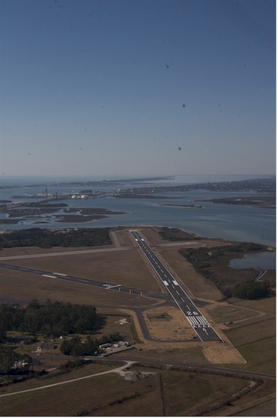
| MICHAEL J. SMITH FIELD BEAUFORT NC |
| |
| Lat: N 3444.0 Long: W 07639.6 Elev: 10 Var: +08 Longest Runway: 5004 | ||
| Clr Del: 125.65 AWOS: 135.37 CTAF: 122.8 | ||
| ||||||||||||||||||||||||||||||||||||||||||||
| ||||||||||||||||||||||||||||||||||||||||||||
| ||||||||||||||||||||||||||||||||||||||||||||
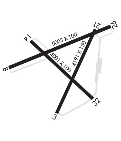
| Rwy | Rwy | |||||||
| 4192x150 | 3328' | 4192x150 | 3676' | |||||
| 5004x100 | 5004' | 5004x100 | 4715' | |||||
| 4001x100 | 4001' | 4001x100 | 3511' | |||||
| Runway ID | Single Wheel | Double Wheel | Double Tandem Wheel | Dual Double Wheel |
| 03/21 | 12,500 | N/A | N/A | N/A |
| 08/26 | N/A | 60,000 | N/A | N/A |
| 14/32 | 12,500 | N/A | N/A | N/A |
| These numbers are Advisory and are not limits. The Airport Manager should have more accurate Weight Limits | ||||
 Airport Diagram might not be current. | |
| Facility Name: | MICHAEL J SMITH FLD |
| City Name: | BEAUFORT |
| County: | CARTERET |
| State abbrev: | NC |
| State Name: | NORTH CAROLINA |
| Ownership: | PUBLICLY OWNED |
| Use: | OPEN TO THE PUBLIC |
| Owner's Name: | BEAUFORT-MOREHEAD ARPT AUTH |
| Address: | 180 AIRPORT ROAD |
| BEAUFORT, NC 28516 | |
| Owner's Phone: | 252-728-1928 |
| Manager's Name: | JANIE MASON |
| Address: | 180 AIRPORT ROAD |
| BEAUFORT, NC 28516 | |
| Phone: | 252-728-1928 |
| FAA Region: | SOUTHERN |
| FAA Field Office: | MEM |
| Date | Sunrise | Sunset |
|---|---|---|
| 12/17/25 Wednesday | 7:08 | 16:58 |
| 12/18/25 Thursday | 7:08 | 16:58 |
| 12/19/25 Friday | 7:09 | 16:59 |
| 12/20/25 Saturday | 7:09 | 16:59 |
| 12/21/25 Sunday | 7:10 | 16:59 |
| 12/22/25 Monday | 7:10 | 17:00 |
| 12/23/25 Tuesday | 7:11 | 17:01 |
| 12/24/25 Wednesday | 7:11 | 17:01 |
| 12/25/25 Thursday | 7:12 | 17:02 |
| 12/26/25 Friday | 7:12 | 17:02 |
| 12/27/25 Saturday | 7:13 | 17:03 |
| 12/28/25 Sunday | 7:13 | 17:04 |
| 12/29/25 Monday | 7:13 | 17:04 |
| 12/30/25 Tuesday | 7:13 | 17:05 |
| Airport Attendance Schedule | 7 Days A Week 0800-DUSK; FOR SERVICE AFTER HOURS CALL 843-465-2846. |
| Airport Status | OPERATIONAL (This Status can change at any time - please check NOTAMS) |
| Airport Lighting Schedule | ACTVT REIL RWY 08 & 26; PAPI RWY 03 & 21; MIRL RWY 03/21 & RWY 08/26 - CTAF. PAPI RWY 08 & 26 OPER CONSLY. |
| Airport Storage Available | Tie Downs, Hanger |
| Extra Services Available | Charter, Flight Instruction, Parachute Jumping, Aircraft Rental, Annual Surveying |
| Wind Indicator | YES - (lighted) |
| Control Tower | NO |
| CTAF Frequency | 122.800 |
| Unicom Frequency | 122.800 |
| Rotating Beacon Color | WG |
| Segmented Circle | YES |
| Landing Fee | NO |
| Airport Inspected | STATE - performed by STATE AERONAUTICAL PERSONNEL |
| Inspection Date | 08/21/2025 |
| Type of Fuel Available | Grade 100LL, JET A-1 (icing inhibitor, freeze point -50C) |
| Airframe Repair Service | MAJOR |
| Power Plant Repair Service | MAJOR |
| Latitude | N3444.0 |
| Longitude | W07639.6 (ESTIMATED) |
| Arpt Elevation | 10ft (SURVEYED) |
| Magnetic Variation | 08W |
| 1 miles N | of BEAUFORT |
| Traffic Pattern Altitude | TPA: SINGLE ENGINE 1000 FT AGL, TWIN ENGINE 1500 FT AGL. |
| Sectional Chart | CHARLOTTE |
| Operations (Reported) | Yearly | Avg. Daily |
|---|---|---|
| General Aviation Transient | 0 | 0 |
| General Aviation Local | 0 | 0 |
| Air Taxi | 0 | 0 |
| Commerical | 0 | 0 |
| Commuter | 0 | 0 |
| Military | 0 | 0 |
| Aircraft based on Field | |
|---|---|
| General Aviation Singles | 0 |
| General Aviation Multi | 0 |
| Jet Aircraft | 0 |
| General Aviation Helicopters | 0 |
| Military Aircraft | 0 |
| Gliders | 0 |
| Ultralights | 0 |
| FSS on field | NO |
| FSS tie-in | RALEIGH |
| FSS Phone | 1-800-WX-BRIEF |
| Who issues Notams | MRH |
| Notam D service at airport | YES |
| ARTCC Name | WASHINGTON |
| Airport Certification | |
| Aircraft Rescue & Firefighting Index | None |
| Airport of Entry | No |
| Custom Landing Rights | YES |
| Joint Civil/Military | No |
| Military Landing rights | YES |
| NATIONAL PLAN OF INTEGRATED AIRPORT SYSTEMS (NPIAS) |
| GRANT AGREEMENTS UNDER FAAP/ADAP/AIP |
| SURPLUS PROPERTY AGREEMENT UNDER PUBLIC LAW 289 |
| ASSURANCES PURSUANT TO TITLE VI, CIVIL RIGHTS ACT OF 1964 |
| AGREEMENT UNDER DLAND OR DCLA HAS EXPIRED. |
| NO LINE OF SIGHT BTWN RWY ENDS. |
| DEER AND BIRDS ON & INVOF ARPT AND BIRD-DROPPED SHELLS MAY CAUSE FOD. |
| NOISE ABATEMENT PROCEDURES IN EFFECT, CTC AMGR 252-728-1928. |
| AVOID OVERFLIGHTS OF BEAUFORT WATERFRONT AND BEAUFORT NATIONAL REGISTER HISTORIC DISTRICT. |
| FOR CD CTC CHERRY POINT APCH AT 252-466-5960. |
| MIL ACFT RWY 08/26 REQUIRED FOR NOISE ABATEMENT. |
| SKYDIVING OPERATIONS - DO NOT OVERFLY ARPT. |
| DUE TO VOLUME OF MIL TFC AND TRNG RCMD ALL ACFT USING MRH CTC CHERRY POINT APP 132.57 AB AND 125.65 PRIOR TO MRH DEP. |
| RWY 14/3 2 RWY 14/32 CLSD. |
Airport Communications & Frequencies:
| ||||||||||||||||
| Runway: 03 | Runway: 21 | ||
| Mag heading: | 33° | Mag heading: | 213° |
| Rwy Slope: | .01% Up | Rwy Slope: | -.01% Down |
| Approach: | Approach: | ||
| Pattern: | Left Traffic | Pattern: | Right Traffic |
| Markings: | NONPRECISION INSTRUMENT | Markings: | NONPRECISION INSTRUMENT |
| Marking Condition: | GOOD | Marking Condition: | GOOD |
| Arresting Dev: | Arresting Dev: | ||
| Lat & Long: | N3443.6 W07639.7 | Lat. & Long.: | N3444.3 W07639.4 |
| Elev: | 6.0 ft. MSL | Elev: | 6.5 ft. MSL |
| TCH: | 44 ft. AGL | TCH: | 54 ft. AGL |
| Visual Glide Path: | 4.00 degrees | Visual Glide Path: | 4.00 degrees |
| Displaced Threshold: | 864 feet | Displaced Threshold: | 516 feet |
| Touchdown Zone: | YES | Touchdown Zone: | YES |
| Touchdown Elev.: | 9.1 feet | Touchdown Elev.: | 9.1 feet |
| Visual Glide Slope: | 2-Light PAPI on LEFT side of Runway | Visual Glide Slope: | 2-Light PAPI on LEFT side of Runway |
| RVR Equipment: | RVR Equipment: | ||
| RVV Equipment: | NO | RVV Equipment: | NO |
| Approach Lights: | Approach Lights: | ||
| REIL: | NO | REIL: | NO |
| Centerline Lights: | NO | Centerline Lights: | NO |
| Touchdown lights: | NO | Touchdown lights: | NO |
| Runway Category: | Runway with a Non-precision Approach | Runway Category: | Runway with a Non-precision Approach |
| Declared Distances: | Declared Distances: | ||
| Obstructions: | ROAD | Obstructions: | TREES |
| Marked: | NOT Marked/Lighted | Marked: | NOT Marked/Lighted |
| Clearance slope: | 5:1; APCH RATIO 42:1 AT DSPLCD THR DUE TO 27 FT MAST 1366 FT FM DSPLCD THLD OFFSET 367 FT L OF CNTRLN. | Clearance slope: | 21:1; APCH RATIO 33:1 AT DSPLCD THR DUE TO 42 FT TREES 1622 FT FM DSPLCD THR OFFSET 142 FT L OF CNTRLN. |
| Obstruction height: | 20 feet AGL | Obstruction height: | 43 feet AGL |
| Dist. from runway: | 312 feet | Dist. from runway: | 1125 feet |
| Centerline offset: | Centerline offset: | 170 feet left of centerline | |
| Comments: | 9 FT FENCE 191 FT FM END OF RWY BOTH SIDES OF CNTRLN. | Comments: | 13 FT TREES 63 FT FM END OF RWY OFFSET 165 FT R OF CNTRLN. |
| Runway: 08 | Runway: 26 | ||
| Mag heading: | 76° | Mag heading: | 256° |
| Rwy Slope: | .06% Up | Rwy Slope: | -.06% Down |
| Approach: | Approach: | ||
| Pattern: | Left Traffic | Pattern: | Right Traffic |
| Markings: | NONPRECISION INSTRUMENT | Markings: | NONPRECISION INSTRUMENT |
| Marking Condition: | GOOD | Marking Condition: | GOOD |
| Arresting Dev: | Arresting Dev: | ||
| Lat & Long: | N3444.0 W07640.1 | Lat. & Long.: | N3444.3 W07639.2 |
| Elev: | 6.4 ft. MSL | Elev: | 9.6 ft. MSL |
| TCH: | 45 ft. AGL | TCH: | 43 ft. AGL |
| Visual Glide Path: | 3.00 degrees | Visual Glide Path: | 3.00 degrees |
| Displaced Threshold: | No | Displaced Threshold: | 289 feet |
| Touchdown Zone: | YES | Touchdown Zone: | YES |
| Touchdown Elev.: | 7.5 feet | Touchdown Elev.: | 8.3 feet |
| Visual Glide Slope: | 2-Light PAPI on LEFT side of Runway | Visual Glide Slope: | 2-Light PAPI on RIGHT side of Runway |
| RVR Equipment: | RVR Equipment: | ||
| RVV Equipment: | NO | RVV Equipment: | NO |
| Approach Lights: | Approach Lights: | ||
| REIL: | YES | REIL: | YES |
| Centerline Lights: | NO | Centerline Lights: | NO |
| Touchdown lights: | NO | Touchdown lights: | NO |
| Runway Category: | Runway with a Non-precision Approach having visibility minimums greater than 3/4 mile | Runway Category: | Runway with a Non-precision Approach having visibility minimums greater than 3/4 mile |
| Declared Distances: | Declared Distances: | ||
| Obstructions: | BOAT; 45 FT MAST HGT. | Obstructions: | ROAD |
| Marked: | NOT Marked/Lighted | Marked: | NOT Marked/Lighted |
| Clearance slope: | 22:1; APCH RATIO 20:1 AT DSPLCD THR DUE TO 21 FT ROAD 627 FT FM DSPLCD THR BOTH SIDES OF CNTRLN. | Clearance slope: | 6:1 |
| Obstruction height: | 35 feet AGL | Obstruction height: | 20 feet AGL |
| Dist. from runway: | 1000 feet | Dist. from runway: | 325 feet |
| Centerline offset: | Centerline offset: | ||
| Comments: | 7 FT BRUSH 100-200 FT FM THR OFFSET 109 FT R OF CNTRLN. | Comments: |
| Runway: 14 | Runway: 32 | ||
| Mag heading: | 141° | Mag heading: | 321° |
| Rwy Slope: | .10% Up | Rwy Slope: | -.10% Down |
| Approach: | Approach: | ||
| Pattern: | Left Traffic | Pattern: | Left Traffic |
| Markings: | Markings: | ||
| Marking Condition: | Marking Condition: | ||
| Arresting Dev: | Arresting Dev: | ||
| Lat & Long: | N3444.2 W07639.9 | Lat. & Long.: | N3443.7 W07639.3 |
| Elev: | 6.1 ft. MSL | Elev: | 10.1 ft. MSL |
| TCH: | TCH: | ||
| Visual Glide Path: | Visual Glide Path: | ||
| Displaced Threshold: | No | Displaced Threshold: | 490 feet |
| Touchdown Zone: | YES | Touchdown Zone: | YES |
| Touchdown Elev.: | 9.4 feet | Touchdown Elev.: | 9.6 feet |
| Visual Glide Slope: | Visual Glide Slope: | ||
| RVR Equipment: | RVR Equipment: | ||
| RVV Equipment: | NO | RVV Equipment: | NO |
| Approach Lights: | Approach Lights: | ||
| REIL: | NO | REIL: | NO |
| Centerline Lights: | NO | Centerline Lights: | NO |
| Touchdown lights: | NO | Touchdown lights: | NO |
| Runway Category: | Runway Category: | ||
| Declared Distances: | Declared Distances: | ||
| Obstructions: | 45 FT MAST HGT. | Obstructions: | |
| Marked: | NOT Marked/Lighted | Marked: | |
| Clearance slope: | Clearance slope: | APCH RATIO 13:1 AT DSPLCD THR DUE TO 61 FT TREES 995 FT FM DSPLCD THR OFFSET 85 FT R OF CNTRLN. | |
| Obstruction height: | Obstruction height: | ||
| Dist. from runway: | Dist. from runway: | ||
| Centerline offset: | Centerline offset: | ||
| Comments: | 10 FT BRUSH 0-200 FT FM THR OFFSET 171 FT R OF CNTRLN, AND 11 FT TREES 43 FT FM THR OFFSET 206 FT R OF CNTRLN. | Comments: |
Thanks for using FltPlan.com
all rights reserved © 1999-2025 by Flight Plan LLC