NOTICE: Information listed below may not be current.Airport Ident: MMIA
| Airport Name: COLIMA, Mexico
Latitude: N1916.6 Longitude: W10334.6
Field Elevation: 2467' Variation: E8° as of 01/06
Time Zone: UTC-6(-5DT)
Daylight Savings: First Sunday in April to the last Saturday in October
Customs: N/A
|
|
| DISTANCE from: | KTEB to MMIA = 1989 nm
| KMIA to MMIA = 1346 nm
| KORD to MMIA = 1579 nm
| KDAL to MMIA = 891 nm
| KSEA to MMIA = 1923 nm
| KLAX to MMIA = 1184 nm
|
|
| AIRPORT TYPE: | | Active airports having permanent type surface runways with less than the minimum facilities. |
|
Rotating Beacon: NO
|
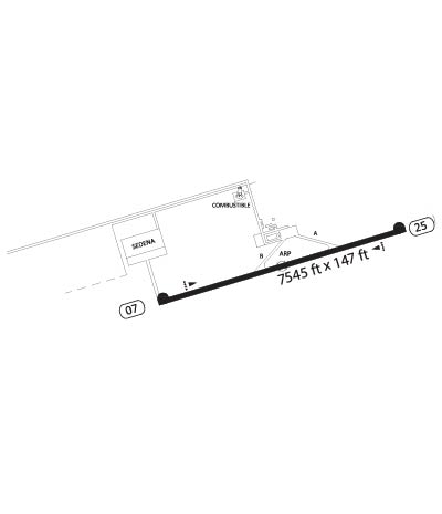
| RUNWAY INFORMATION: | Runway Ident: 25 /07
Runway Length: 7546
Runway Width: 148
Runway Surface: ASPHALT, ASPHALTIC CONCRETE, TAR MACADAM, OR BITUMEN BOUND MACADAM (INCLUDING ANY OF THESE SURFACE TYPES WITH CONCRETE ENDS).
Runway PCN Rating: 038FBXT - Flexible, Subgrade-MEDIUM, Tire Pressure-MEDIUM LIMITED TO 217 PSI
Runway PCN Evaluation Method: Technical Evaluation.
Runway Open: YES
| Runway 25 Information
Runway True Heading: 254°
Takeoff Distance Available: 7746
Landing Distance Available: 7546
Runway Latitude: N1916.8
Runway Longitude: W10334.0
Runway Elevation:
Runway Slope: N/A
Runway TDZE:
Runway Lighting: MIRL, PAPI
| Runway 07 Information
Runway True Heading: 74°
Takeoff Distance Available: 7746
Landing Distance Available: 7546
Runway Latitude: N1916.4
Runway Longitude: W10335.3
Runway Elevation:
Runway Slope: N/A
Runway TDZE: N/A
Runway Lighting: MIRL, PAPI
|
|
|
COMMUNICATION INFORMATION
TOWER - TWR
118.9
|
AIRPORT NAVAIDS
COL - COLIMA (VOR-DME) - ON FIELD
|