
| MONROE RGNL MONROE LA |
| |
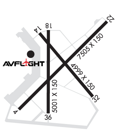
| Lat: N 3230.6 Long: W 09202.2 Elev: 79 Var: -03 Longest Runway: 7504 | ||
| Clr Del: 121.65 Dept. ATIS: 125.05 Arr. ATIS: 125.05 Ground: 121.9 Tower: 118.9 | ||
| ||||||||||||||||||||||||||||||||||||||||||||||||||||||||||||||||||||
| ||||||||||||||||||||||||||||||||||||||||||||||||||||||||||||||||||||
| ||||||||||||||||||||||||||||||||||||||||||||||||||||||||||||||||||||
| ||||||||||||||||||||||||||||||||||||||||||||||||||||||||||||||||||||
| Rwy | Rwy | |||||||
| 7504x150 | 7504' | 109.50 - 042° | 7504x150 | 7504' | 109.50 - 222° | |||
| 6301x150 | 6301' | 6301x150 | 6301' | |||||
| Runway ID | Single Wheel | Double Wheel | Double Tandem Wheel | Dual Double Wheel |
| 04/22 | 75,000 | 170,000 | 290,000 | N/A |
| 14/32 | 75,000 | 170,000 | 290,000 | N/A |
| These numbers are Advisory and are not limits. The Airport Manager should have more accurate Weight Limits | ||||
 Airport Diagram might not be current. | |
| Facility Name: | MONROE RGNL |
| City Name: | MONROE |
| County: | OUACHITA |
| State abbrev: | LA |
| State Name: | LOUISIANA |
| Ownership: | PUBLICLY OWNED |
| Use: | OPEN TO THE PUBLIC |
| Owner's Name: | CITY OF MONROE |
| Address: | PO BOX 123 |
| MONROE, LA 71210 | |
| Owner's Phone: | 318-329-2200 |
| Manager's Name: | CHARLES BUTCHER |
| Address: | 5400 OPERATIONS RD |
| MONROE, LA 71203 | |
| Phone: | 318-329-2460 |
| FAA Region: | SOUTHWEST |
| FAA Field Office: | LNM |
| Date | Sunrise | Sunset |
|---|---|---|
| 09/24/21 Friday | 6:57 | 19:02 |
| 09/25/21 Saturday | 6:58 | 19:01 |
| 09/26/21 Sunday | 6:59 | 19:00 |
| 09/27/21 Monday | 6:59 | 18:58 |
| 09/28/21 Tuesday | 7:00 | 18:57 |
| 09/29/21 Wednesday | 7:01 | 18:56 |
| 09/30/21 Thursday | 7:01 | 18:54 |
| 10/01/21 Friday | 7:02 | 18:53 |
| 10/02/21 Saturday | 7:03 | 18:52 |
| 10/03/21 Sunday | 7:03 | 18:51 |
| 10/04/21 Monday | 7:04 | 18:49 |
| 10/05/21 Tuesday | 7:05 | 18:48 |
| 10/06/21 Wednesday | 7:05 | 18:47 |
| 10/07/21 Thursday | 7:06 | 18:45 |
| Airport Attendance Schedule | CONTINUOUS |
| Airport Status | OPERATIONAL (This Status can change at any time - please check NOTAMS) |
| Airport Lighting Schedule | WHEN ATCT CLSD ACTVT MALSR RWYS 04 & 22; HIRL RWY 04/22; MIRL RWY 14/32; TWY LGTS - CTAF. PAPI RWYS 04, 22, 14 & 32 OPR CONSLY. |
| Airport Storage Available | Tie Downs, Hanger |
| Extra Services Available | Air Freight, Air Ambulance, Cargo Handling, Charter, Flight Instruction, Aircraft Rental, Aircraft Sales |
| Wind Indicator | YES - (lighted) |
| Control Tower | YES |
| CTAF Frequency | 118.900 |
| Unicom Frequency | 122.950 |
| Rotating Beacon Color | CLEAR-GREEN (Light Land Airport) |
| Segmented Circle | YES |
| Landing Fee | NO |
| Airport Inspected | FEDERAL - performed by FAA AIRPORTS FIELD PERSONNEL |
| Inspection Date | 04/24/2019 |
| Type of Fuel Available | Grade 100LL, JET A (freeze point -40C) |
| Airframe Repair Service | MAJOR |
| Power Plant Repair Service | MAJOR |
| Latitude | N3230.6 |
| Longitude | W09202.2 (ESTIMATED) |
| Arpt Elevation | 79ft (SURVEYED) |
| Magnetic Variation | 03E |
| 3 miles E | of MONROE |
| Traffic Pattern Altitude | |
| Sectional Chart | MEMPHIS |
| Operations (Reported) | Yearly | Avg. Daily |
|---|---|---|
| General Aviation Transient | 13933 | 38 |
| General Aviation Local | 1293 | 4 |
| Air Taxi | 5488 | 15 |
| Commerical | 1220 | 3 |
| Commuter | 0 | 0 |
| Military | 6791 | 19 |
| Aircraft based on Field | |
|---|---|
| General Aviation Singles | 16 |
| General Aviation Multi | 10 |
| Jet Aircraft | 0 |
| General Aviation Helicopters | 0 |
| Military Aircraft | 0 |
| Gliders | 0 |
| Ultralights | 0 |
| FSS on field | NO |
| FSS tie-in | DE RIDDER |
| FSS Phone | 1-800-WX-BRIEF |
| Who issues Notams | MLU |
| Notam D service at airport | YES |
| ARTCC Name | FORT WORTH |
| Airport Certification | AIRPORT RECEIVING SCHEDULED AIR CARRIER SERVICE FROM CARRIERS CERTIFICATED BY THE CIVIL AERONAUTICS BOARD; TWYS J & E EAST OF RWY 04/22 NOT AVBL FOR ACR OPNS WITH OVER 9 PSGR SEATS. |
| Aircraft Rescue & Firefighting Index | AIRPORT HAS A CERTIFICATE UNDER CFR PART 139 |
| Airport of Entry | No |
| Custom Landing Rights | No |
| Joint Civil/Military | No |
| Military Landing rights | YES |
| NATIONAL PLAN OF INTEGRATED AIRPORT SYSTEMS (NPIAS) |
| GRANT AGREEMENTS UNDER FAAP/ADAP/AIP |
| SURPLUS PROPERTY AGREEMENT UNDER PUBLIC LAW 289 |
| ASSURANCES PURSUANT TO TITLE VI, CIVIL RIGHTS ACT OF 1964 |
| TWY E EAST OF RWY 04/22 RESTRICTED TO ACFT WITH WINGSPAN UNDER 90'. |
| BIRD ACT ON AND INVOF ARPT. |
| FOR CD WHEN ATCT IS CLSD CTC FORT WORTH ARTCC AT 817-858-7584 |
Airport Communications & Frequencies:
| |||||||||||||||||||||||||||||||||||||||
| Runway: 04 | Runway: 22 | ||
| Mag heading: | 42° | Mag heading: | 222° |
| Rwy Slope: | -.01% Down | Rwy Slope: | .01% Up |
| Approach: | ILS | Approach: | ILS |
| Pattern: | Left Traffic | Pattern: | Left Traffic |
| Markings: | PRECISION INSTRUMENT | Markings: | PRECISION INSTRUMENT |
| Marking Condition: | GOOD | Marking Condition: | GOOD |
| Arresting Dev: | Arresting Dev: | ||
| Lat & Long: | N3230.2 W09202.7 | Lat. & Long.: | N3231.1 W09201.7 |
| Elev: | 75.5 ft. MSL | Elev: | 74.5 ft. MSL |
| TCH: | 50 ft. AGL | TCH: | 50 ft. AGL |
| Visual Glide Path: | 3.00 degrees | Visual Glide Path: | 3.00 degrees |
| Displaced Threshold: | No | Displaced Threshold: | No |
| Touchdown Zone: | YES | Touchdown Zone: | YES |
| Touchdown Elev.: | 77.8 feet | Touchdown Elev.: | 78.0 feet |
| Visual Glide Slope: | 4-Light PAPI on LEFT side of Runway | Visual Glide Slope: | 4-Light PAPI on LEFT side of Runway |
| RVR Equipment: | TOUCHDOWN | RVR Equipment: | ROLLOUT |
| RVV Equipment: | NO | RVV Equipment: | NO |
| Approach Lights: | MALSR - 1,400 foot medium intensity approach lighting system with runway alignment indicator lights | Approach Lights: | MALSR - 1,400 foot medium intensity approach lighting system with runway alignment indicator lights |
| REIL: | NO | REIL: | NO |
| Centerline Lights: | NO | Centerline Lights: | NO |
| Touchdown lights: | NO | Touchdown lights: | NO |
| Runway Category: | Precision Instrument Runway | Runway Category: | Precision Instrument Runway |
| Declared Distances: | TORA:7504' TODA:7504' ASDA:7504' LDA:7504' | Declared Distances: | TORA:7504' TODA:7504' ASDA:7504' LDA:7504' |
| Runway: 14 | Runway: 32 | ||
| Mag heading: | 137° | Mag heading: | 317° |
| Rwy Slope: | -.08% Down | Rwy Slope: | .08% Up |
| Approach: | Approach: | ||
| Pattern: | Left Traffic | Pattern: | Left Traffic |
| Markings: | NONPRECISION INSTRUMENT | Markings: | NONPRECISION INSTRUMENT |
| Marking Condition: | GOOD | Marking Condition: | GOOD |
| Arresting Dev: | Arresting Dev: | ||
| Lat & Long: | N3231.0 W09202.5 | Lat. & Long.: | N3230.2 W09201.7 |
| Elev: | 78.6 ft. MSL | Elev: | 73.7 ft. MSL |
| TCH: | 50 ft. AGL | TCH: | 53 ft. AGL |
| Visual Glide Path: | 3.00 degrees | Visual Glide Path: | 3.00 degrees |
| Displaced Threshold: | No | Displaced Threshold: | No |
| Touchdown Zone: | YES | Touchdown Zone: | YES |
| Touchdown Elev.: | 79.2 feet | Touchdown Elev.: | 76.2 feet |
| Visual Glide Slope: | 4-Light PAPI on LEFT side of Runway | Visual Glide Slope: | 4-Light PAPI on LEFT side of Runway |
| RVR Equipment: | RVR Equipment: | ||
| RVV Equipment: | NO | RVV Equipment: | NO |
| Approach Lights: | Approach Lights: | ||
| REIL: | YES | REIL: | YES |
| Centerline Lights: | NO | Centerline Lights: | NO |
| Touchdown lights: | NO | Touchdown lights: | NO |
| Runway Category: | Runway with a Non-precision Approach having visibility minimums greater than 3/4 mile | Runway Category: | Runway with a Non-precision Approach having visibility minimums greater than 3/4 mile |
| Declared Distances: | TORA:6301' TODA:6301' ASDA:6301' LDA:6301' | Declared Distances: | TORA:6301' TODA:6301' ASDA:6301' LDA:6301' |
Thanks for using FltPlan.com
all rights reserved © 1999-2021 by Flight Plan LLC


