
| MAPLE LAKE MUNI MAPLE LAKE MN |
| |
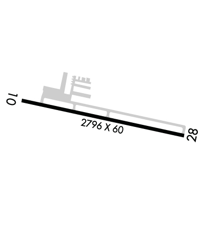
| Lat: N 4514.2 Long: W 09359.1 Elev: 1028 Var: -03 Longest Runway: 2796 | ||
| AWOS: 128.32 CTAF: 122.8 | ||
| ||||||||||||||||||||||||||||||||||||||||||||
| ||||||||||||||||||||||||||||||||||||||||||||
| ||||||||||||||||||||||||||||||||||||||||||||
| Rwy | Rwy | |||||||
| 2796x60 | 2696' | 2796x60 | 2796' | |||||
| Runway ID | Single Wheel | Double Wheel | Double Tandem Wheel | Dual Double Wheel |
| 10/28 | N/A | N/A | N/A | N/A |
| These numbers are Advisory and are not limits. The Airport Manager should have more accurate Weight Limits | ||||
 Airport Diagram might not be current. | |
| Facility Name: | MAPLE LAKE MUNI-BILL MAVENCAMP SR FLD |
| City Name: | MAPLE LAKE |
| County: | WRIGHT |
| State abbrev: | MN |
| State Name: | MINNESOTA |
| Ownership: | PUBLICLY OWNED |
| Use: | OPEN TO THE PUBLIC |
| Owner's Name: | CITY OF MAPLE LAKE |
| Address: | PO BOX 757, 10 MAPLE AVE S |
| MAPLE LAKE, MN 55358 | |
| Owner's Phone: | 320-963-3611 |
| Manager's Name: | GERALD SAWATZKE |
| Address: | PO BOX 757, 10 MAPLE AVE S |
| MAPLE LAKE, MN 55358 | |
| Phone: | 320-963-3738; OR 612-490-8459. |
| FAA Region: | GREAT LAKES |
| FAA Field Office: | DMA |
| Date | Sunrise | Sunset |
|---|---|---|
| 09/24/21 Friday | 7:05 | 19:10 |
| 09/25/21 Saturday | 7:06 | 19:08 |
| 09/26/21 Sunday | 7:08 | 19:06 |
| 09/27/21 Monday | 7:09 | 19:04 |
| 09/28/21 Tuesday | 7:10 | 19:02 |
| 09/29/21 Wednesday | 7:11 | 19:00 |
| 09/30/21 Thursday | 7:13 | 18:59 |
| 10/01/21 Friday | 7:14 | 18:57 |
| 10/02/21 Saturday | 7:15 | 18:55 |
| 10/03/21 Sunday | 7:16 | 18:53 |
| 10/04/21 Monday | 7:18 | 18:51 |
| 10/05/21 Tuesday | 7:19 | 18:49 |
| 10/06/21 Wednesday | 7:20 | 18:47 |
| 10/07/21 Thursday | 7:21 | 18:45 |
| Airport Attendance Schedule | UNATTENDED |
| Airport Status | OPERATIONAL (This Status can change at any time - please check NOTAMS) |
| Airport Lighting Schedule | SS-SR |
| Airport Storage Available | Tie Downs |
| Extra Services Available | NONE |
| Wind Indicator | YES - (lighted) |
| Control Tower | NO |
| CTAF Frequency | 122.800 |
| Unicom Frequency | 122.800 |
| Rotating Beacon Color | CLEAR-GREEN (Light Land Airport) |
| Segmented Circle | NO |
| Landing Fee | NO |
| Airport Inspected | STATE - performed by STATE AERONAUTICAL PERSONNEL |
| Inspection Date | 04/26/2021 |
| Type of Fuel Available | Grade 100LL; -10FUEL AVBL H24 SELF SER VIA CREDIT CARD. FUEL GRADE NOT MKD ON PUMP. |
| Airframe Repair Service | NONE |
| Power Plant Repair Service | NONE |
| Latitude | N4514.2 |
| Longitude | W09359.1 (ESTIMATED) |
| Arpt Elevation | 1028ft (SURVEYED) |
| Magnetic Variation | 03E |
| 1 miles NE | of MAPLE LAKE |
| Traffic Pattern Altitude | |
| Sectional Chart | TWIN CITIES |
| Operations (Reported) | Yearly | Avg. Daily |
|---|---|---|
| General Aviation Transient | 4000 | 11 |
| General Aviation Local | 15000 | 41 |
| Air Taxi | 1000 | 3 |
| Commerical | 0 | 0 |
| Commuter | 0 | 0 |
| Military | 800 | 2 |
| Aircraft based on Field | |
|---|---|
| General Aviation Singles | 43 |
| General Aviation Multi | 5 |
| Jet Aircraft | 0 |
| General Aviation Helicopters | 0 |
| Military Aircraft | 0 |
| Gliders | 0 |
| Ultralights | 5 |
| FSS on field | NO |
| FSS tie-in | PRINCETON |
| FSS Phone | 1-800-WX-BRIEF |
| Who issues Notams | MGG |
| Notam D service at airport | YES |
| ARTCC Name | MINNEAPOLIS |
| Airport Certification | |
| Aircraft Rescue & Firefighting Index | None |
| Airport of Entry | No |
| Custom Landing Rights | No |
| Joint Civil/Military | No |
| Military Landing rights | No |
| THIS AIRPORT HAS BEEN SURVEYED BY THE NATIONAL GEODETIC SURVEY. |
| ONE TKOF/LDG PER FLT OPRN, NO TGL OR TRG. |
| MIGRATORY WATERFOWL ON & INVOF ARPT. |
| FOR CD CTC MINNEAPOLIS APCH AT 612-726-9086. |
| RWY 10/2 8 NSTD LIRL DUE TO 400 FT SPACING BTN LGTS, 20 FT FM EDGE. |
Airport Communications & Frequencies:
| ||||||||||||||
| Runway: 10 | Runway: 28 | ||
| Mag heading: | 99° | Mag heading: | 279° |
| Rwy Slope: | .14% Up | Rwy Slope: | -.14% Down |
| Approach: | Approach: | ||
| Pattern: | Left Traffic | Pattern: | Left Traffic |
| Markings: | BASIC | Markings: | BASIC |
| Marking Condition: | GOOD | Marking Condition: | GOOD |
| Arresting Dev: | Arresting Dev: | ||
| Lat & Long: | N4514.2 W09359.5 | Lat. & Long.: | N4514.1 W09358.8 |
| Elev: | 1024.0 ft. MSL | Elev: | 1028.0 ft. MSL |
| TCH: | TCH: | ||
| Visual Glide Path: | Visual Glide Path: | ||
| Displaced Threshold: | 100 feet | Displaced Threshold: | No |
| Touchdown Zone: | YES | Touchdown Zone: | YES |
| Touchdown Elev.: | 1028.0 feet | Touchdown Elev.: | 1028.0 feet |
| Visual Glide Slope: | Visual Glide Slope: | ||
| RVR Equipment: | RVR Equipment: | ||
| RVV Equipment: | NO | RVV Equipment: | NO |
| Approach Lights: | Approach Lights: | ||
| REIL: | NO | REIL: | NO |
| Centerline Lights: | NO | Centerline Lights: | NO |
| Touchdown lights: | NO | Touchdown lights: | NO |
| Runway Category: | Runway with a Visual Approach | Runway Category: | Runway with a Visual Approach |
| Declared Distances: | Declared Distances: | ||
| Obstructions: | PLINE | Obstructions: | TREES |
| Marked: | LIGHTED | Marked: | NOT Marked/Lighted |
| Clearance slope: | 8:1 | Clearance slope: | 11:1 |
| Obstruction height: | 39 feet AGL | Obstruction height: | 53 feet AGL |
| Dist. from runway: | 535 feet | Dist. from runway: | 791 feet |
| Centerline offset: | 143 left of centerline | Centerline offset: | 126 feet right of centerline |
| Comments: | Comments: | +8 FT RSG TRRN, 170 FT DIST, 80 FT R. |
Thanks for using FltPlan.com
all rights reserved © 1999-2021 by Flight Plan LLC
