
| BOWMAN FIELD LOUISVILLE KY |
| |
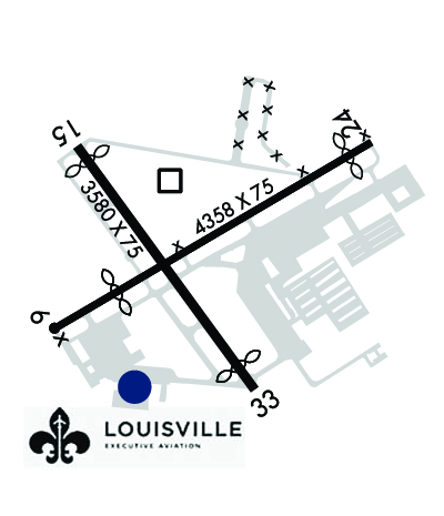
| Lat: N 3813.7 Long: W 08539.8 Elev: 546 Var: +04 Longest Runway: 4358 | ||
| Clr Del: 118.9 Dept. ATIS: 124.15 Arr. ATIS: 124.15 Ground: 121.8 Tower: 119.5 | ||
| |||||||||||||||||||||||||||||||||||||||||||||||||||||||||||||||||||||
| |||||||||||||||||||||||||||||||||||||||||||||||||||||||||||||||||||||
| |||||||||||||||||||||||||||||||||||||||||||||||||||||||||||||||||||||
| FBOs at nearby airports who want your business: | |||||||||||||||||
| |||||||||||||||||
| |||||||||||||||||
| Rwy | Rwy | |||||||
| 4358x75 | 3510' | 4358x75 | 4048' | |||||
| 3580x75 | 3374' | 3580x75 | 3238' | |||||
| Runway ID | Single Wheel | Double Wheel | Double Tandem Wheel | Dual Double Wheel |
| 06/24 | 30,000 | N/A | N/A | N/A |
| 15/33 | 30,000 | N/A | N/A | N/A |
| These numbers are Advisory and are not limits. The Airport Manager should have more accurate Weight Limits | ||||
 Airport Diagram might not be current. | |
| Facility Name: | BOWMAN FLD |
| City Name: | LOUISVILLE |
| County: | JEFFERSON |
| State abbrev: | KY |
| State Name: | KENTUCKY |
| Ownership: | PUBLICLY OWNED |
| Use: | OPEN TO THE PUBLIC |
| Owner's Name: | REGIONAL AIRPORT AUTH |
| Address: | P O BOX 9129 |
| LOUISVILLE, KY 40209-0129 | |
| Owner's Phone: | 502-368-6524 |
| Manager's Name: | JORGIE DERMODY |
| Address: | 3345 ROGER E SCHUPP STREET |
| LOUISVILLE, KY 40205 | |
| Phone: | 502-243-7305; 502-851-5903 |
| FAA Region: | SOUTHERN |
| FAA Field Office: | MEM |

| Date | Sunrise | Sunset |
|---|---|---|
| 03/22/26 Sunday | 7:44 | 19:56 |
| 03/23/26 Monday | 7:42 | 19:57 |
| 03/24/26 Tuesday | 7:40 | 19:58 |
| 03/25/26 Wednesday | 7:39 | 19:59 |
| 03/26/26 Thursday | 7:37 | 20:00 |
| 03/27/26 Friday | 7:36 | 20:01 |
| 03/28/26 Saturday | 7:34 | 20:02 |
| 03/29/26 Sunday | 7:33 | 20:03 |
| 03/30/26 Monday | 7:31 | 20:04 |
| 03/31/26 Tuesday | 7:30 | 20:05 |
| 04/01/26 Wednesday | 7:28 | 20:06 |
| 04/02/26 Thursday | 7:27 | 20:07 |
| 04/03/26 Friday | 7:25 | 20:08 |
| 04/04/26 Saturday | 7:24 | 20:08 |
| Airport Attendance Schedule | 7 Days A Week 0700-2200 |
| Airport Status | OPERATIONAL (This Status can change at any time - please check NOTAMS) |
| Airport Lighting Schedule | ACTVT MIRL RWY 06/24 & 15/33 - CTAF. |
| Airport Storage Available | Tie Downs, Hanger |
| Extra Services Available | Air Ambulance, Avionics, Charter, Flight Instruction, Aircraft Rental, Aircraft Sales |
| Wind Indicator | YES - (lighted) |
| Control Tower | YES |
| CTAF Frequency | 119.500 |
| Unicom Frequency | 122.950 |
| Rotating Beacon Color | WG |
| Segmented Circle | NO |
| Landing Fee | NO |
| Airport Inspected | STATE - performed by STATE AERONAUTICAL PERSONNEL |
| Inspection Date | 06/20/2022 |
| Type of Fuel Available | Grade 100LL, JET A (freeze point -40C) |
| Airframe Repair Service | MAJOR |
| Power Plant Repair Service | MAJOR |
| Latitude | N3813.7 |
| Longitude | W08539.8 (ESTIMATED) |
| Arpt Elevation | 545ft (SURVEYED) |
| Magnetic Variation | 04W |
| 5 miles SE | of LOUISVILLE |
| Traffic Pattern Altitude | |
| Sectional Chart | ST LOUIS |
| Operations (Reported) | Yearly | Avg. Daily |
|---|---|---|
| General Aviation Transient | 0 | 0 |
| General Aviation Local | 0 | 0 |
| Air Taxi | 0 | 0 |
| Commerical | 0 | 0 |
| Commuter | 0 | 0 |
| Military | 0 | 0 |
| Aircraft based on Field | |
|---|---|
| General Aviation Singles | 0 |
| General Aviation Multi | 0 |
| Jet Aircraft | 0 |
| General Aviation Helicopters | 0 |
| Military Aircraft | 0 |
| Gliders | 0 |
| Ultralights | 0 |
| FSS on field | NO |
| FSS tie-in | LOUISVILLE |
| FSS Phone | 1-800-WX-BRIEF |
| Who issues Notams | LOU |
| Notam D service at airport | YES |
| ARTCC Name | INDIANAPOLIS |
| Airport Certification | |
| Aircraft Rescue & Firefighting Index | None |
| Airport of Entry | No |
| Custom Landing Rights | No |
| Joint Civil/Military | No |
| Military Landing rights | YES |
| NATIONAL PLAN OF INTEGRATED AIRPORT SYSTEMS (NPIAS) |
| GRANT AGREEMENTS UNDER FAAP/ADAP/AIP |
| SURPLUS PROPERTY AGREEMENT UNDER PUBLIC LAW 289 |
| ASSURANCES PURSUANT TO TITLE VI, CIVIL RIGHTS ACT OF 1964 |
| AGREEMENT UNDER DLAND OR DCLA HAS EXPIRED. |
| COMPASS ROSE LCTD AT ADMIN BLDG NOT FOR COMPASS CALIBRATION USE. |
| 24 HR PPR FOR MIL ROTARY WING. |
| FOR CD WHEN ATCT CLSD, CTC SDF ATCT 502-375-7499. |
| NOISE ABATEMENT: NO PRACTICE APCH MON-SAT 2200-0700. SUN 2200-0900, OR WHEN TWR CLSD. |
| STAGE 3 COMPLIANCE RQRD FOR TURBOJET; PPR OVR 30000 LB GWT - AMGR. |
| TRNG OPS NA WHEN ATCT CLSD. |
| OBSTNS & TREES IN ALL APCH SFCS. |
| ADCUS FLT NOTIFICATION SVC AVBL. |
| BIRDS ON & INVOF ARPT DURG DALGT HR. |
Airport Communications & Frequencies:
| ||||||||||||||||||||||||||
| Runway: 06 | Runway: 24 | ||
| Mag heading: | 64° | Mag heading: | 244° |
| Rwy Slope: | -.31% Down | Rwy Slope: | .31% Up |
| Approach: | Approach: | ||
| Pattern: | Left Traffic | Pattern: | Left Traffic |
| Markings: | NONPRECISION INSTRUMENT | Markings: | NONPRECISION INSTRUMENT |
| Marking Condition: | GOOD | Marking Condition: | GOOD |
| Arresting Dev: | Arresting Dev: | ||
| Lat & Long: | N3813.5 W08540.2 | Lat. & Long.: | N3813.9 W08539.4 |
| Elev: | 544.4 ft. MSL | Elev: | 530.8 ft. MSL |
| TCH: | 45 ft. AGL | TCH: | 53 ft. AGL |
| Visual Glide Path: | 3.50 degrees | Visual Glide Path: | 3.00 degrees |
| Displaced Threshold: | 848 feet | Displaced Threshold: | 310 feet |
| Touchdown Zone: | YES | Touchdown Zone: | YES |
| Touchdown Elev.: | 545.1 feet | Touchdown Elev.: | 545.1 feet |
| Visual Glide Slope: | 2-Light PAPI on LEFT side of Runway | Visual Glide Slope: | 2-Light PAPI on LEFT side of Runway |
| RVR Equipment: | RVR Equipment: | ||
| RVV Equipment: | NO | RVV Equipment: | NO |
| Approach Lights: | Approach Lights: | ||
| REIL: | NO | REIL: | YES |
| Centerline Lights: | NO | Centerline Lights: | NO |
| Touchdown lights: | NO | Touchdown lights: | NO |
| Runway Category: | Runway with a Visual Approach | Runway Category: | Runway with a Non-precision Approach |
| Declared Distances: | TORA:4047' TODA:4357' ASDA:4316' LDA:3469' | Declared Distances: | TORA:3509' TODA:4357' ASDA:4165' LDA:3856' |
| Obstructions: | TREE | Obstructions: | TREE |
| Marked: | NOT Marked/Lighted | Marked: | NOT Marked/Lighted |
| Clearance slope: | 1:1; APCH RATIO 20:1 TO DTHR. | Clearance slope: | 11:1; APCH RATIO 20:1 TO DTHR. |
| Obstruction height: | 10 feet AGL | Obstruction height: | 17 feet AGL |
| Dist. from runway: | 204 feet | Dist. from runway: | 388 feet |
| Centerline offset: | 76 right of centerline | Centerline offset: | 80 feet left of centerline |
| Comments: | 8 FT FENCE 108 FT FM RWY END; 956 FT FM DTHR. ROAD 159 FT FM RWY END; 1007 FT FM DTHR. | Comments: |
| Runway: 15 | Runway: 33 | ||
| Mag heading: | 148° | Mag heading: | 328° |
| Rwy Slope: | -.56% Down | Rwy Slope: | .56% Up |
| Approach: | Approach: | ||
| Pattern: | Left Traffic | Pattern: | Left Traffic |
| Markings: | NONPRECISION INSTRUMENT | Markings: | NONPRECISION INSTRUMENT |
| Marking Condition: | GOOD | Marking Condition: | GOOD |
| Arresting Dev: | Arresting Dev: | ||
| Lat & Long: | N3813.9 W08540.1 | Lat. & Long.: | N3813.4 W08539.7 |
| Elev: | 538.6 ft. MSL | Elev: | 518.7 ft. MSL |
| TCH: | 45 ft. AGL | TCH: | 45 ft. AGL |
| Visual Glide Path: | 3.50 degrees | Visual Glide Path: | 3.25 degrees |
| Displaced Threshold: | 206 feet | Displaced Threshold: | 342 feet |
| Touchdown Zone: | YES | Touchdown Zone: | YES |
| Touchdown Elev.: | 545.5 feet | Touchdown Elev.: | 545.5 feet |
| Visual Glide Slope: | 2-Light PAPI on LEFT side of Runway | Visual Glide Slope: | 2-Light PAPI on LEFT side of Runway |
| RVR Equipment: | RVR Equipment: | ||
| RVV Equipment: | NO | RVV Equipment: | NO |
| Approach Lights: | Approach Lights: | ||
| REIL: | NO | REIL: | YES |
| Centerline Lights: | NO | Centerline Lights: | NO |
| Touchdown lights: | NO | Touchdown lights: | NO |
| Runway Category: | Runway with a Visual Approach | Runway Category: | Runway with a Non-precision Approach |
| Declared Distances: | TORA:3238' TODA:3579' ASDA:3579' LDA:3373' | Declared Distances: | TORA:3373' TODA:3579' ASDA:3466' LDA:3125' |
| Obstructions: | OTHER; 6 FT PATH & GOLF CARTS. | Obstructions: | ROAD |
| Marked: | NOT Marked/Lighted | Marked: | NOT Marked/Lighted |
| Clearance slope: | 8:1; APCH RATIO 20:1 TO DTHR. | Clearance slope: | 11:1; APCH RATIO 20:1 TO DTHR. |
| Obstruction height: | 7 feet AGL | Obstruction height: | 8 feet AGL |
| Dist. from runway: | 262 feet | Dist. from runway: | 289 feet |
| Centerline offset: | 214 left of centerline | Centerline offset: | 263 feet left of centerline |
| Comments: | +8 FT FENCE 188 FT FM RWY END; 394 FT FM DTHR. | Comments: |
Thanks for using FltPlan.com
all rights reserved © 1999-2026 by Flight Plan LLC


