
| QUILLAYUTE QUILLAYUTE WA |
| |
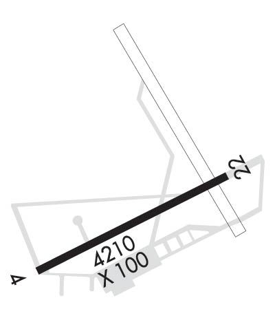
| Lat: N 4756.2 Long: W 12433.8 Elev: 194 Var: -21 Longest Runway: 4211 | ||
| AWOS: 135.22 CTAF: 122.9 | ||
| ||||||||||||||||||||||||||||||||
| ||||||||||||||||||||||||||||||||
| ||||||||||||||||||||||||||||||||
| Rwy | Rwy | |||||||
| 4211x100 | 4211' | 4211x100 | 4211' | |||||
| Runway ID | Single Wheel | Double Wheel | Double Tandem Wheel | Dual Double Wheel |
| 04/22 | 30,000 | 50,000 | N/A | N/A |
| These numbers are Advisory and are not limits. The Airport Manager should have more accurate Weight Limits | ||||
| FltPlan does not have IFR approach charts available for KUIL. |
 Airport Diagram might not be current. | |
| Facility Name: | QUILLAYUTE |
| City Name: | QUILLAYUTE |
| County: | CLALLAM |
| State abbrev: | WA |
| State Name: | WASHINGTON |
| Ownership: | PUBLICLY OWNED |
| Use: | OPEN TO THE PUBLIC |
| Owner's Name: | CITY OF FORKS |
| Address: | 500 EAST DIVISION ST. |
| FORKS, WA 98331 | |
| Owner's Phone: | 360-374-5412; EXT 245. |
| Manager's Name: | ROD FLECK |
| Address: | 500 EAST DIVISION ST. |
| FORKS, WA 98331 | |
| Phone: | 360-374-5412 |
| FAA Region: | NORTHWEST MOUNTAIN |
| FAA Field Office: | SEA |
| Date | Sunrise | Sunset |
|---|---|---|
| 10/25/25 Saturday | 7:52 | 18:12 |
| 10/26/25 Sunday | 7:54 | 18:10 |
| 10/27/25 Monday | 7:55 | 18:08 |
| 10/28/25 Tuesday | 7:57 | 18:07 |
| 10/29/25 Wednesday | 7:58 | 18:05 |
| 10/30/25 Thursday | 8:00 | 18:03 |
| 10/31/25 Friday | 8:01 | 18:02 |
| 11/01/25 Saturday | 8:03 | 18:00 |
| 11/02/25 Sunday | 7:04 | 16:59 |
| 11/03/25 Monday | 7:06 | 16:57 |
| 11/04/25 Tuesday | 7:07 | 16:55 |
| 11/05/25 Wednesday | 7:09 | 16:54 |
| 11/06/25 Thursday | 7:11 | 16:53 |
| 11/07/25 Friday | 7:12 | 16:51 |
| Airport Attendance Schedule | UNATTENDED |
| Airport Status | OPERATIONAL (This Status can change at any time - please check NOTAMS) |
| Airport Lighting Schedule | |
| Airport Storage Available | Tie Downs |
| Extra Services Available | NONE |
| Wind Indicator | YES - (unlit) |
| Control Tower | NO |
| CTAF Frequency | 122.900 |
| Unicom Frequency | |
| Rotating Beacon Color | |
| Segmented Circle | YES |
| Landing Fee | NO |
| Airport Inspected | STATE - performed by STATE AERONAUTICAL PERSONNEL |
| Inspection Date | 08/02/2023 |
| Type of Fuel Available | None |
| Airframe Repair Service | NONE |
| Power Plant Repair Service | NONE |
| Latitude | N4756.2 |
| Longitude | W12433.8 (ESTIMATED) |
| Arpt Elevation | 194ft (SURVEYED) |
| Magnetic Variation | 21E |
| 7 miles E | of QUILLAYUTE |
| Traffic Pattern Altitude | |
| Sectional Chart | SEATTLE |
| Operations (Reported) | Yearly | Avg. Daily |
|---|---|---|
| General Aviation Transient | 0 | 0 |
| General Aviation Local | 0 | 0 |
| Air Taxi | 0 | 0 |
| Commerical | 0 | 0 |
| Commuter | 0 | 0 |
| Military | 0 | 0 |
| Aircraft based on Field | |
|---|---|
| General Aviation Singles | 0 |
| General Aviation Multi | 0 |
| Jet Aircraft | 0 |
| General Aviation Helicopters | 0 |
| Military Aircraft | 0 |
| Gliders | 0 |
| Ultralights | 0 |
| FSS on field | NO |
| FSS tie-in | SEATTLE |
| FSS Phone | 1-800-WX-BRIEF |
| Who issues Notams | UIL |
| Notam D service at airport | YES |
| ARTCC Name | SEATTLE |
| Airport Certification | |
| Aircraft Rescue & Firefighting Index | None |
| Airport of Entry | No |
| Custom Landing Rights | No |
| Joint Civil/Military | No |
| Military Landing rights | YES |
| NATIONAL PLAN OF INTEGRATED AIRPORT SYSTEMS (NPIAS) |
| SURPLUS PROPERTY AGREEMENT UNDER PUBLIC LAW 289 |
| PEDESTRIANS; VEHICLES & ANIMALS ON & INVOF RY. |
| 4 FT SQUARE GRATED DRAIN ON N SIDE OF APRON. |
| FOR CD CTC SEATTLE ARTCC AT 253-351-3694. |
| Runway: 04 | Runway: 22 | ||
| Mag heading: | 37° | Mag heading: | 217° |
| Rwy Slope: | .42% Up | Rwy Slope: | -.42% Down |
| Approach: | Approach: | ||
| Pattern: | Left Traffic | Pattern: | Left Traffic |
| Markings: | BASIC | Markings: | BASIC |
| Marking Condition: | FAIR | Marking Condition: | FAIR |
| Arresting Dev: | Arresting Dev: | ||
| Lat & Long: | N4756.0 W12434.2 | Lat. & Long.: | N4756.4 W12433.3 |
| Elev: | 176.4 ft. MSL | Elev: | 194.1 ft. MSL |
| TCH: | TCH: | ||
| Visual Glide Path: | Visual Glide Path: | ||
| Displaced Threshold: | No | Displaced Threshold: | No |
| Touchdown Zone: | YES | Touchdown Zone: | YES |
| Touchdown Elev.: | 187.3 feet | Touchdown Elev.: | 194.1 feet |
| Visual Glide Slope: | Visual Glide Slope: | ||
| RVR Equipment: | RVR Equipment: | ||
| RVV Equipment: | NO | RVV Equipment: | NO |
| Approach Lights: | Approach Lights: | ||
| REIL: | NO | REIL: | NO |
| Centerline Lights: | NO | Centerline Lights: | NO |
| Touchdown lights: | NO | Touchdown lights: | NO |
| Runway Category: | Runway with a Visual Approach | Runway Category: | Runway with a Visual Approach |
| Declared Distances: | Declared Distances: | ||
| Obstructions: | TREES | Obstructions: | |
| Marked: | NOT Marked/Lighted | Marked: | |
| Clearance slope: | 19:1 | Clearance slope: | 20:1 |
| Obstruction height: | 70 feet AGL | Obstruction height: | |
| Dist. from runway: | 1535 feet | Dist. from runway: | |
| Centerline offset: | Centerline offset: | ||
| Comments: | Comments: |
Thanks for using FltPlan.com
all rights reserved © 1999-2025 by Flight Plan LLC
