
| MACKAY MACKAY ID |
| |
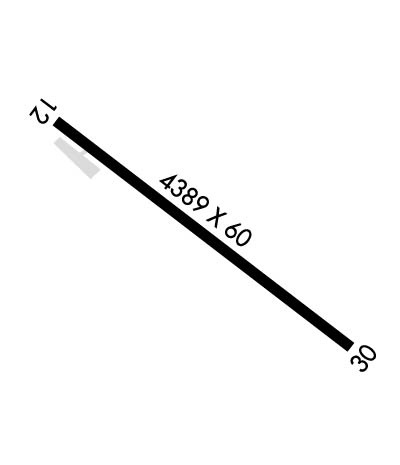
| Lat: N 4354.6 Long: W 11336.1 Elev: 5892 Var: -16 Longest Runway: 4389 | ||
| CTAF: 122.9 | ||
| ||||||||||||||||||||||||||||||||
| ||||||||||||||||||||||||||||||||
| Rwy | Rwy | |||||||
| 4389x60 | 4389' | 4389x60 | 4389' | |||||
| Runway ID | Single Wheel | Double Wheel | Double Tandem Wheel | Dual Double Wheel |
| 12/30 | N/A | N/A | N/A | N/A |
| H1 | N/A | N/A | N/A | N/A |
| These numbers are Advisory and are not limits. The Airport Manager should have more accurate Weight Limits | ||||
| FltPlan does not have IFR approach charts available for KU62. |
 Airport Diagram might not be current. | |
| Facility Name: | MACKAY |
| City Name: | MACKAY |
| County: | CUSTER |
| State abbrev: | ID |
| State Name: | IDAHO |
| Ownership: | PUBLICLY OWNED |
| Use: | OPEN TO THE PUBLIC |
| Owner's Name: | CITY OF MACKAY |
| Address: | PO BOX 509 |
| MACKAY, ID 83251 | |
| Owner's Phone: | 208-588-2274 |
| Manager's Name: | MIKE FOSTER |
| Address: | PO BOX 509 |
| MACKAY, ID 83251 | |
| Phone: | 208-721-3450 |
| FAA Region: | NORTHWEST MOUNTAIN |
| FAA Field Office: | HLN |
| Date | Sunrise | Sunset |
|---|---|---|
| 03/19/26 Thursday | 7:40 | 19:45 |
| 03/20/26 Friday | 7:38 | 19:47 |
| 03/21/26 Saturday | 7:36 | 19:48 |
| 03/22/26 Sunday | 7:34 | 19:49 |
| 03/23/26 Monday | 7:33 | 19:50 |
| 03/24/26 Tuesday | 7:31 | 19:52 |
| 03/25/26 Wednesday | 7:29 | 19:53 |
| 03/26/26 Thursday | 7:27 | 19:54 |
| 03/27/26 Friday | 7:25 | 19:55 |
| 03/28/26 Saturday | 7:23 | 19:56 |
| 03/29/26 Sunday | 7:22 | 19:58 |
| 03/30/26 Monday | 7:20 | 19:59 |
| 03/31/26 Tuesday | 7:18 | 20:00 |
| 04/01/26 Wednesday | 7:16 | 20:01 |
| Airport Attendance Schedule | UNATTENDED |
| Airport Status | OPERATIONAL (This Status can change at any time - please check NOTAMS) |
| Airport Lighting Schedule | |
| Airport Storage Available | Tie Downs |
| Extra Services Available | NONE |
| Wind Indicator | YES - (unlit) |
| Control Tower | NO |
| CTAF Frequency | 122.900 |
| Unicom Frequency | |
| Rotating Beacon Color | |
| Segmented Circle | YES |
| Landing Fee | NO |
| Airport Inspected | STATE - performed by STATE AERONAUTICAL PERSONNEL |
| Inspection Date | 05/24/2025 |
| Type of Fuel Available | None |
| Airframe Repair Service | None |
| Power Plant Repair Service | None |
| Latitude | N4354.6 |
| Longitude | W11336.1 (ESTIMATED) |
| Arpt Elevation | 5892ft (ESTIMATED) |
| Magnetic Variation | 16E |
| 1 miles SE | of MACKAY |
| Traffic Pattern Altitude | |
| Sectional Chart | SALT LAKE CITY |
| Operations (Reported) | Yearly | Avg. Daily |
|---|---|---|
| General Aviation Transient | 0 | 0 |
| General Aviation Local | 0 | 0 |
| Air Taxi | 0 | 0 |
| Commerical | 0 | 0 |
| Commuter | 0 | 0 |
| Military | 0 | 0 |
| Aircraft based on Field | |
|---|---|
| General Aviation Singles | 0 |
| General Aviation Multi | 0 |
| Jet Aircraft | 0 |
| General Aviation Helicopters | 0 |
| Military Aircraft | 0 |
| Gliders | 0 |
| Ultralights | 0 |
| FSS on field | NO |
| FSS tie-in | BOISE |
| FSS Phone | 1-800-WX-BRIEF |
| Who issues Notams | BOI |
| Notam D service at airport | YES |
| ARTCC Name | SALT LAKE CITY |
| Airport Certification | |
| Aircraft Rescue & Firefighting Index | None |
| Airport of Entry | No |
| Custom Landing Rights | No |
| Joint Civil/Military | No |
| Military Landing rights | No |
| GRANT AGREEMENT HAS EXPIRED; HOWEVER, AGREEMENT REMAINS IN EFFECT FOR THIS FACILITY AS LONG AS IT IS PUBLIC USE. |
| FOR CD CTC SALT LAKE ARTCC AT 801-320-2568. |
| WINTER MAINT NA. |
| RWY 12/3 0 WINDS PMTG ARR RWY 30; DEP RWY 12. |
| RWY H1 LCTD BTN RWY & PRKG AREA. |
| RWY 12 +35 FT PWR LINE MKD AT 1600 FT ON CNTRLN. |
| RWY 12/3 0 RY 12/30 RWY. DISPLAYS VERY ROUGH CHIP SEAL WITH UNEVEN SFC IN PLACES. |
| Runway: 12 | Runway: 30 | ||
| Mag heading: | N/A | Mag heading: | N/A |
| Rwy Slope: | -.66% Down | Rwy Slope: | .66% Up |
| Approach: | Approach: | ||
| Pattern: | Left Traffic | Pattern: | Left Traffic |
| Markings: | BASIC | Markings: | BASIC |
| Marking Condition: | POOR; RWY MARKINGS ARE SUB-STANDARD W/NRS. TOO SMALL IN SIZE AND A VERY CROOKED CTR LINE. | Marking Condition: | POOR; RWY MARKINGS ARE SUB-STD W/NRS. TOO SML IN SIZE AND A VERY CROOKED CTR LINE. |
| Arresting Dev: | Arresting Dev: | ||
| Lat & Long: | N4354.9 W11336.5 | Lat. & Long.: | N4354.4 W11335.8 |
| Elev: | 5892.0 ft. MSL | Elev: | 5863.0 ft. MSL |
| TCH: | TCH: | ||
| Visual Glide Path: | Visual Glide Path: | ||
| Displaced Threshold: | No | Displaced Threshold: | No |
| Touchdown Zone: | NO | Touchdown Zone: | NO |
| Touchdown Elev.: | Touchdown Elev.: | ||
| Visual Glide Slope: | Visual Glide Slope: | ||
| RVR Equipment: | RVR Equipment: | ||
| RVV Equipment: | NO | RVV Equipment: | NO |
| Approach Lights: | Approach Lights: | ||
| REIL: | NO | REIL: | NO |
| Centerline Lights: | NO | Centerline Lights: | NO |
| Touchdown lights: | NO | Touchdown lights: | NO |
| Runway Category: | Runway with a Visual Approach | Runway Category: | Runway with a Visual Approach |
| Declared Distances: | Declared Distances: | ||
| Obstructions: | PLINE | Obstructions: | BRUSH |
| Marked: | MARKED | Marked: | NOT Marked/Lighted |
| Clearance slope: | Clearance slope: | 8:1 | |
| Obstruction height: | 35 feet AGL | Obstruction height: | 25 feet AGL |
| Dist. from runway: | 200 feet | Dist. from runway: | 400 feet |
| Centerline offset: | 115 left of centerline | Centerline offset: | |
| Comments: | +35 FT PWR LINE AT RWY END 115 FT L. | Comments: |
Thanks for using FltPlan.com
all rights reserved © 1999-2026 by Flight Plan LLC
