
| MC GHEE TYSON KNOXVILLE TN |
| |
| Lat: N 3548.7 Long: W 08359.6 Elev: 986 Var: +06 Longest Runway: 10000 | ||
| Clr Del: 121.65 Dept. ATIS: 128.35 Arr. ATIS: 128.35 Ground: 121.9 Tower: 121.2 | ||
| ||||||||||||||||||||||||||||||||||||||||||||||||||||||||||||||||||||
| ||||||||||||||||||||||||||||||||||||||||||||||||||||||||||||||||||||
| ||||||||||||||||||||||||||||||||||||||||||||||||||||||||||||||||||||
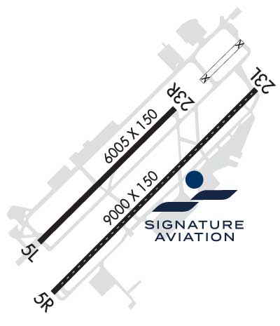
| Rwy | Rwy | |||||||
| 10000x150 | 9510' | 110.30 - 050° | 10000x150 | 9495' | 111.70 - 230° | |||
| 9000x150 | 9000' | 9000x150 | 8603' | 110.75 - 230° | ||||
| Runway ID | Single Wheel | Double Wheel | Double Tandem Wheel | Dual Double Wheel |
| 05L/23R | 120,000 | 250,000 | 550,000 | 1,120,000 |
| 05R/23L | 75,000 | 250,000 | 489,000 | 1,106,000 |
| These numbers are Advisory and are not limits. The Airport Manager should have more accurate Weight Limits | ||||
 Airport Diagram might not be current. | |
| Facility Name: | MC GHEE TYSON |
| City Name: | KNOXVILLE |
| County: | BLOUNT |
| State abbrev: | TN |
| State Name: | TENNESSEE |
| Ownership: | PUBLICLY OWNED |
| Use: | OPEN TO THE PUBLIC |
| Owner's Name: | METRO KNOXVILLE ARPT AUTH |
| Address: | MC GHEE TYSON AIRPORT, 2055 ALCOA HWY |
| ALCOA, TN 37701 | |
| Owner's Phone: | 865-342-3000 |
| Manager's Name: | PATRICK WILSON |
| Address: | P.O. BOX 15600 |
| KNOXVILLE, TN 37901 | |
| Phone: | 865-342-3088 |
| FAA Region: | SOUTHERN |
| FAA Field Office: | MEM |
| Date | Sunrise | Sunset |
|---|---|---|
| 04/11/26 Saturday | 7:09 | 20:06 |
| 04/12/26 Sunday | 7:07 | 20:07 |
| 04/13/26 Monday | 7:06 | 20:08 |
| 04/14/26 Tuesday | 7:05 | 20:08 |
| 04/15/26 Wednesday | 7:03 | 20:09 |
| 04/16/26 Thursday | 7:02 | 20:10 |
| 04/17/26 Friday | 7:01 | 20:11 |
| 04/18/26 Saturday | 7:00 | 20:12 |
| 04/19/26 Sunday | 6:58 | 20:13 |
| 04/20/26 Monday | 6:57 | 20:13 |
| 04/21/26 Tuesday | 6:56 | 20:14 |
| 04/22/26 Wednesday | 6:54 | 20:15 |
| 04/23/26 Thursday | 6:53 | 20:16 |
| 04/24/26 Friday | 6:52 | 20:17 |
| Airport Attendance Schedule | CONTINUOUS |
| Airport Status | OPERATIONAL (This Status can change at any time - please check NOTAMS) |
| Airport Lighting Schedule | SS-SR |
| Airport Storage Available | Tie Downs, Hanger |
| Extra Services Available | Air Freight, Avionics, Cargo Handling, Charter, Flight Instruction, Aircraft Rental, Aircraft Sales, Annual Surveying |
| Wind Indicator | YES - (lighted) |
| Control Tower | YES |
| CTAF Frequency | |
| Unicom Frequency | 122.950 |
| Rotating Beacon Color | WG |
| Segmented Circle | YES |
| Landing Fee | NO |
| Airport Inspected | FEDERAL - performed by FAA AIRPORTS FIELD PERSONNEL |
| Inspection Date | 06/13/2025 |
| Type of Fuel Available | Grade 100LL, JET A (freeze point -40C)A++; -10MIL CONTR FUEL AVBL. |
| Airframe Repair Service | MAJOR |
| Power Plant Repair Service | MAJOR |
| Latitude | N3548.7 |
| Longitude | W08359.6 (ESTIMATED) |
| Arpt Elevation | 986ft (SURVEYED) |
| Magnetic Variation | 06W |
| 10 miles S | of KNOXVILLE |
| Traffic Pattern Altitude | |
| Sectional Chart | ATLANTA |
| Operations (Reported) | Yearly | Avg. Daily |
|---|---|---|
| General Aviation Transient | 0 | 0 |
| General Aviation Local | 0 | 0 |
| Air Taxi | 0 | 0 |
| Commerical | 0 | 0 |
| Commuter | 0 | 0 |
| Military | 0 | 0 |
| Aircraft based on Field | |
|---|---|
| General Aviation Singles | 0 |
| General Aviation Multi | 0 |
| Jet Aircraft | 0 |
| General Aviation Helicopters | 0 |
| Military Aircraft | 0 |
| Gliders | 0 |
| Ultralights | 0 |
| FSS on field | NO |
| FSS tie-in | NASHVILLE |
| FSS Phone | 1-800-WX-BRIEF |
| Who issues Notams | TYS |
| Notam D service at airport | YES |
| ARTCC Name | ATLANTA |
| Airport Certification | AIRPORT RECEIVING SCHEDULED AIR CARRIER SERVICE FROM CARRIERS CERTIFICATED BY THE CIVIL AERONAUTICS BOARD |
| Aircraft Rescue & Firefighting Index | AIRPORT HAS A CERTIFICATE UNDER CFR PART 139 |
| Airport of Entry | No |
| Custom Landing Rights | YES |
| Joint Civil/Military | No |
| Military Landing rights | YES |
| NATIONAL PLAN OF INTEGRATED AIRPORT SYSTEMS (NPIAS) |
| GRANT AGREEMENTS UNDER FAAP/ADAP/AIP |
| SURPLUS PROPERTY AGREEMENT UNDER PUBLIC LAW 289 |
| ASSURANCES PURSUANT TO TITLE VI, CIVIL RIGHTS ACT OF 1964 |
| AGREEMENT UNDER DLAND OR DCLA HAS EXPIRED. |
| WIDE BODY USE CTN TURNING ONTO TWY A FM RAMP 4, 5 & 6. |
| CTN: PTN OF TWY A NEAR RWY 05R APCH END NOT VSB FM TWR. |
| ANG OPS CTC SODA CTL 303.025. |
| ANG: COMD POST H24 - D266-4371/ C865-336-4371. AMGR DOES NOT ISSUE OR STORE COMSEC FOR TSNT. TMPRY STOR OF CLASSIFIED MATERIALS UP TO TOP SECRET AT COMD POST. |
| ANG: PPR 24 HR PN RQR, LTD TO OFFL BUS ONLY, CTC AIRFIELD MGMT DSN 266-4404/4419, C865-336-4404/4419. OPR 0700-1630 MON-FRI (CLSD EV OTH MON), FAC CLSD SAT, SUN AND HOL. |
| CTN: HOLD SHORT LINE FOR RWY 23L SLIGHTLY N OF TWY A-8. |
| ANG: ARNG RAMP NOT SUITABLE FOR AMC ACFT EXC C-21. |
| CSTMS/AG/IMG: MIL CUSTOMS 72 HR PPR. |
| RWY 5L/23R & 5R/23L WT BRG CPTY FOR 2S LNDG GEAR IS 175. |
| ACFT DESIGN GROUP V OR LRGR USING TRML RAMP RQR PPR 865-342-3177. |
| GA RAMP NOT AVBL FOR ACR OPS. |
| ARNG: BASEOPS OPR 0700-1630 MON-FRI (CLSD EV OTH MON), FAC CLSD SAT, SUN AND HOL. C865-985-4639/4644, DSN 683-4180. |
| RWY 05R/23L DIST RMNG SIGNS ARE REMOVED. |
| BIRDS ON & INVOF OF ARPT; INCRD OCT-APR. |
| CIVIL PPR TO USE TWYS G1, G2, G3 & G SOUTH OF TWY G4 - ANG 865-336-4371. |
| RWY 23L & 23R DEP MNTN RWY HDG UNTIL PASSING RESIDENTIAL AREA S OF EXTDD CNTRLN UNLESS INSTRD BY ATC. |
| RWY 05L/ 23RPCR VALUE: 761/R/B/W/T |
| RWY 05R/ 23LPCR VALUE: 492/F/B/X/U |
Airport Communications & Frequencies:
| ||||||||||||||||||||||||||||||||||||||||||||||||
| Runway: 05L | Runway: 23R | ||
| Mag heading: | 51° | Mag heading: | 231° |
| Rwy Slope: | .61% Up | Rwy Slope: | -.61% Down |
| Approach: | ILS | Approach: | ILS |
| Pattern: | Left Traffic | Pattern: | Right Traffic |
| Markings: | PRECISION INSTRUMENT | Markings: | PRECISION INSTRUMENT |
| Marking Condition: | GOOD | Marking Condition: | GOOD |
| Arresting Dev: | Arresting Dev: | ||
| Lat & Long: | N3548.2 W08400.4 | Lat. & Long.: | N3549.4 W08359.0 |
| Elev: | 925.9 ft. MSL | Elev: | 986.4 ft. MSL |
| TCH: | 55 ft. AGL | TCH: | 56 ft. AGL |
| Visual Glide Path: | 3.00 degrees | Visual Glide Path: | 3.00 degrees |
| Displaced Threshold: | 490 feet | Displaced Threshold: | 505 feet |
| Touchdown Zone: | YES | Touchdown Zone: | YES |
| Touchdown Elev.: | 953.2 feet | Touchdown Elev.: | 984.3 feet |
| Visual Glide Slope: | 4-Light PAPI on LEFT side of Runway | Visual Glide Slope: | 4-Light PAPI on LEFT side of Runway |
| RVR Equipment: | TOUCHDOWN-MIDFIELD-ROLLOUT | RVR Equipment: | TOUCHDOWN-MIDFIELD-ROLLOUT |
| RVV Equipment: | NO | RVV Equipment: | NO |
| Approach Lights: | MALSR - 1,400 foot medium intensity approach lighting system with runway alignment indicator lights | Approach Lights: | ALSF2 - standard 2,400 foot high intensity approach lighting system with sequenced flashers, Category II or III |
| REIL: | NO | REIL: | NO |
| Centerline Lights: | YES | Centerline Lights: | YES |
| Touchdown lights: | NO | Touchdown lights: | YES |
| Runway Category: | Precision Instrument Runway | Runway Category: | Precision Instrument Runway |
| Declared Distances: | TORA:10000' TODA:10000' ASDA:10000' LDA:9508' | Declared Distances: | TORA:10000' TODA:10000' ASDA:10000' LDA:9495' |
| Runway: 05R | Runway: 23L | ||
| Mag heading: | 51° | Mag heading: | 231° |
| Rwy Slope: | .27% Up | Rwy Slope: | -.27% Down |
| Approach: | Approach: | ILS/DME | |
| Pattern: | Right Traffic | Pattern: | Left Traffic |
| Markings: | PRECISION INSTRUMENT | Markings: | PRECISION INSTRUMENT |
| Marking Condition: | GOOD | Marking Condition: | GOOD |
| Arresting Dev: | Arresting Dev: | ||
| Lat & Long: | N3548.0 W08400.2 | Lat. & Long.: | N3549.1 W08359.0 |
| Elev: | 938.3 ft. MSL | Elev: | 962.3 ft. MSL |
| TCH: | 50 ft. AGL | TCH: | 50 ft. AGL |
| Visual Glide Path: | 3.00 degrees | Visual Glide Path: | 3.00 degrees |
| Displaced Threshold: | No | Displaced Threshold: | 397 feet |
| Touchdown Zone: | YES | Touchdown Zone: | YES |
| Touchdown Elev.: | 959.1 feet | Touchdown Elev.: | 965.2 feet |
| Visual Glide Slope: | 4-Light PAPI on LEFT side of Runway | Visual Glide Slope: | 4-Light PAPI on LEFT side of Runway |
| RVR Equipment: | ROLLOUT | RVR Equipment: | TOUCHDOWN |
| RVV Equipment: | NO | RVV Equipment: | NO |
| Approach Lights: | Approach Lights: | ||
| REIL: | YES | REIL: | YES |
| Centerline Lights: | YES | Centerline Lights: | YES |
| Touchdown lights: | NO | Touchdown lights: | NO |
| Runway Category: | Runway with a Non-precision Approach having visibility minimums greater than 3/4 mile | Runway Category: | Precision Instrument Runway |
| Declared Distances: | TORA:9000' TODA:9000' ASDA:8600' LDA:8600' | Declared Distances: | TORA:9000' TODA:9000' ASDA:9000' LDA:8600' |
Thanks for using FltPlan.com
all rights reserved © 1999-2026 by Flight Plan LLC


