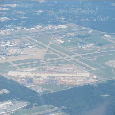
| TULSA INTL TULSA OK |
| |
| Lat: N 3611.9 Long: W 09553.3 Elev: 678 Var: -03 Longest Runway: 10000 | ||
| Clr Del: 134.05 Dept. ATIS: 124.9 Arr. ATIS: 124.9 Ground: 121.9 Tower: 118.7/121.2 | ||
| ||||||||||||||||||||||||||||||||||||||||||||||||||||||||||||||||||||
| ||||||||||||||||||||||||||||||||||||||||||||||||||||||||||||||||||||
| ||||||||||||||||||||||||||||||||||||||||||||||||||||||||||||||||||||
| ||||||||||||||||||||||||||||||||||||||||||||||||||||||||||||||||||||
| ||||||||||||||||||||||||||||||||||||||||||||||||||||||||||||||||||||
| ||||||||||||||||||||||||||||||||||||||||||||||||||||||||||||||||||||
| ||||||||||||||||||||||||||||||||||||||||||||||||||||||||||||||||||||
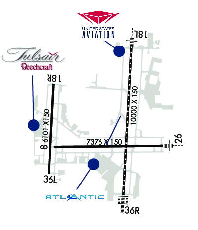
| FBOs at nearby airports who want your business: | |||||||||||||||||
| |||||||||||||||||
| Rwy | Rwy | |||||||
| 7376x150 | 7376' | 7376x150 | 7376' | |||||
| 10000x150 | 10000' | 109.70 - 180° | 10000x150 | 10000' | 110.30 - 000° | |||
| 6101x150 | 6101' | 111.10 - 180° | 6101x150 | 6101' | ||||
| Runway ID | Single Wheel | Double Wheel | Double Tandem Wheel | Dual Double Wheel |
| 08/26 | 75,000 | 200,000 | 350,000 | N/A |
| 18L/36R | 75,000 | 200,000 | 400,000 | N/A |
| 18R/36L | 60,000 | 100,000 | N/A | N/A |
| These numbers are Advisory and are not limits. The Airport Manager should have more accurate Weight Limits | ||||
 Airport Diagram might not be current. | |
| Facility Name: | TULSA INTL |
| City Name: | TULSA |
| County: | TULSA |
| State abbrev: | OK |
| State Name: | OKLAHOMA |
| Ownership: | PUBLICLY OWNED |
| Use: | OPEN TO THE PUBLIC |
| Owner's Name: | CITY OF TULSA |
| Address: | TULSA ARPT AUTH. BOX 581838 |
| TULSA, OK 74158 | |
| Owner's Phone: | 918-838-5000 |
| Manager's Name: | ALEXIS HIGGINS |
| Address: | PO BOX 581838 |
| TULSA, OK 74158 | |
| Phone: | 918-838-5000 |
| FAA Region: | SOUTHWEST |
| FAA Field Office: | AOK |
| Date | Sunrise | Sunset |
|---|---|---|
| 09/24/21 Friday | 7:13 | 19:18 |
| 09/25/21 Saturday | 7:14 | 19:16 |
| 09/26/21 Sunday | 7:14 | 19:15 |
| 09/27/21 Monday | 7:15 | 19:13 |
| 09/28/21 Tuesday | 7:16 | 19:12 |
| 09/29/21 Wednesday | 7:17 | 19:10 |
| 09/30/21 Thursday | 7:18 | 19:09 |
| 10/01/21 Friday | 7:18 | 19:07 |
| 10/02/21 Saturday | 7:19 | 19:06 |
| 10/03/21 Sunday | 7:20 | 19:05 |
| 10/04/21 Monday | 7:21 | 19:03 |
| 10/05/21 Tuesday | 7:22 | 19:02 |
| 10/06/21 Wednesday | 7:23 | 19:00 |
| 10/07/21 Thursday | 7:23 | 18:59 |
| Airport Attendance Schedule | CONTINUOUS |
| Airport Status | OPERATIONAL (This Status can change at any time - please check NOTAMS) |
| Airport Lighting Schedule | SS-SR |
| Airport Storage Available | Tie Downs, Hanger |
| Extra Services Available | Air Freight, Air Ambulance, Avionics, Cargo Handling, Charter, Flight Instruction, Aircraft Rental, Aircraft Sales |
| Wind Indicator | YES - (lighted) |
| Control Tower | YES |
| CTAF Frequency | |
| Unicom Frequency | 122.950 |
| Rotating Beacon Color | CLEAR-GREEN (Light Land Airport) |
| Segmented Circle | NO |
| Landing Fee | NO |
| Airport Inspected | FEDERAL - performed by FAA AIRPORTS FIELD PERSONNEL |
| Inspection Date | 08/15/2019 |
| Type of Fuel Available | Grade 100LL, JET A (freeze point -40C), JET A-1 (freeze point -50C), JET B (wide-cut turbine fuel, freeze point -50C) |
| Airframe Repair Service | MAJOR |
| Power Plant Repair Service | MAJOR |
| Latitude | N3611.9 |
| Longitude | W09553.3 (ESTIMATED) |
| Arpt Elevation | 677ft (SURVEYED) |
| Magnetic Variation | 03E |
| 5 miles NE | of TULSA |
| Traffic Pattern Altitude | |
| Sectional Chart | KANSAS CITY |
| Operations (Reported) | Yearly | Avg. Daily |
|---|---|---|
| General Aviation Transient | 21284 | 58 |
| General Aviation Local | 5376 | 15 |
| Air Taxi | 15628 | 43 |
| Commerical | 34711 | 95 |
| Commuter | 0 | 0 |
| Military | 15621 | 43 |
| Aircraft based on Field | |
|---|---|
| General Aviation Singles | 47 |
| General Aviation Multi | 16 |
| Jet Aircraft | 17 |
| General Aviation Helicopters | 1 |
| Military Aircraft | 22 |
| Gliders | 0 |
| Ultralights | 0 |
| FSS on field | NO |
| FSS tie-in | MC ALESTER |
| FSS Phone | 1-800-WX-BRIEF |
| Who issues Notams | TUL |
| Notam D service at airport | YES |
| ARTCC Name | KANSAS CITY |
| Airport Certification | AIRPORT RECEIVING SCHEDULED AIR CARRIER SERVICE FROM CARRIERS CERTIFICATED BY THE CIVIL AERONAUTICS BOARD |
| Aircraft Rescue & Firefighting Index | AIRPORT HAS A CERTIFICATE UNDER CFR PART 139 |
| Airport of Entry | No |
| Custom Landing Rights | YES |
| Joint Civil/Military | No |
| Military Landing rights | YES |
| NATIONAL PLAN OF INTEGRATED AIRPORT SYSTEMS (NPIAS) |
| GRANT AGREEMENTS UNDER FAAP/ADAP/AIP |
| SURPLUS PROPERTY AGREEMENT UNDER PUBLIC LAW 289 |
| SURPLUS PROPERTY AGREEMENT UNDER REGULATION 16-WAA |
| CONVEYANCE UNDER SCETION 16, FEDERAL AIRPORT ACT OF 1946 OR SECTION 23, AIRPORT AND AIRWAY DEVELOPMENT ACT OF 1970 |
| ASSURANCES PURSUANT TO TITLE VI, CIVIL RIGHTS ACT OF 1964 |
| AGREEMENT UNDER DLAND OR DCLA HAS EXPIRED. |
| <4000FT BLACKTOP TRACK 1.5NM E RWY 26; DO NOT MISTAKE FOR RWY. |
| TAXILANES LZ, LA, & NN NOT VISIBLE FM ATCT. |
| TWY L SOUTH OF TWY L5 NOT VISIBLE FM ATCT. |
| THE FLWG AREAS ARE RSTRD TO WTS INDICATED: TWY JJ S-35; TWY M-2 S-35/D-52; TWY HH S-45/D-60; TWY L NORTH OF RWY 8/26 S-55/D-60; TWY L SOUTH OF RWY 8/26 S-55/D-60; TWY L4 S-55/D-60 |
| NOISE ABATEMENT ALL RYS: CLIMB TO 3000 FT ASAP AFT TKOF. |
| IREG WIND PATTERN AER 18R. |
| TAXILANE QQ NOT VISIBLE FM ATCT. |
Airport Communications & Frequencies:
| |||||||||||||||||||||||||||||||||||||||||||||||||||||||||||||
| Runway: 08 | Runway: 26 | ||
| Mag heading: | 86° | Mag heading: | 266° |
| Rwy Slope: | -.52% Down | Rwy Slope: | .52% Up |
| Approach: | Approach: | ||
| Pattern: | Left Traffic | Pattern: | Left Traffic |
| Markings: | NONPRECISION INSTRUMENT | Markings: | NONPRECISION INSTRUMENT |
| Marking Condition: | GOOD | Marking Condition: | GOOD |
| Arresting Dev: | BAK-14; BAK-14 BAK-12A(B) (1500'). | Arresting Dev: | BAK-14; BAK-14 BAK-12A(B) (1500'). |
| Lat & Long: | N3611.7 W09553.9 | Lat. & Long.: | N3611.7 W09552.4 |
| Elev: | 671.2 ft. MSL | Elev: | 633.0 ft. MSL |
| TCH: | 52 ft. AGL | TCH: | 57 ft. AGL |
| Visual Glide Path: | 3.00 degrees | Visual Glide Path: | 3.00 degrees |
| Displaced Threshold: | No | Displaced Threshold: | No |
| Touchdown Zone: | YES | Touchdown Zone: | YES |
| Touchdown Elev.: | 671.2 feet | Touchdown Elev.: | 651.6 feet |
| Visual Glide Slope: | 4-Light PAPI on LEFT side of Runway; PAPI UNUSABLE BYD 8 DEGS BOTH SIDES OF CNTRLN. | Visual Glide Slope: | 4-Light PAPI on LEFT side of Runway; PAPI UNUSABLE BYD 7 DEGS RIGHT & 9 DEGS LEFT OF CNTRLN. |
| RVR Equipment: | RVR Equipment: | ||
| RVV Equipment: | NO | RVV Equipment: | NO |
| Approach Lights: | Approach Lights: | MALSR - 1,400 foot medium intensity approach lighting system with runway alignment indicator lights | |
| REIL: | YES | REIL: | YES |
| Centerline Lights: | NO | Centerline Lights: | NO |
| Touchdown lights: | NO | Touchdown lights: | NO |
| Runway Category: | Runway with a Non-precision Approach having visibility minimums greater than 3/4 mile | Runway Category: | Runway with a Non-precision Approach having visibility minimums greater than 3/4 mile |
| Declared Distances: | TORA:7376' TODA:7376' ASDA:7376' LDA:7376' | Declared Distances: | TORA:7376' TODA:7376' ASDA:7376' LDA:7376' |
| Obstructions: | TREE | Obstructions: | |
| Marked: | NOT Marked/Lighted | Marked: | |
| Clearance slope: | 43:1 | Clearance slope: | 50:1 |
| Obstruction height: | 36 feet AGL | Obstruction height: | |
| Dist. from runway: | 1775 feet | Dist. from runway: | |
| Centerline offset: | 430 right of centerline | Centerline offset: | |
| Comments: | Comments: |
| Runway: 18L | Runway: 36R | ||
| Mag heading: | 180° | Mag heading: | 0° |
| Rwy Slope: | .17% Up | Rwy Slope: | -.17% Down |
| Approach: | ILS/DME | Approach: | ILS/DME |
| Pattern: | Left Traffic | Pattern: | Right Traffic |
| Markings: | PRECISION INSTRUMENT | Markings: | PRECISION INSTRUMENT |
| Marking Condition: | GOOD | Marking Condition: | GOOD |
| Arresting Dev: | BAK-14; BAK-14 BAK-12A(B) (1500'). | Arresting Dev: | BAK-14; BAK-14 BAK-12A(B) (1500'). |
| Lat & Long: | N3612.8 W09552.9 | Lat. & Long.: | N3611.2 W09553.0 |
| Elev: | 626.6 ft. MSL | Elev: | 643.8 ft. MSL |
| TCH: | 53 ft. AGL | TCH: | 57 ft. AGL |
| Visual Glide Path: | 2.75 degrees | Visual Glide Path: | 3.00 degrees |
| Displaced Threshold: | No | Displaced Threshold: | No |
| Touchdown Zone: | YES | Touchdown Zone: | YES |
| Touchdown Elev.: | 641.1 feet | Touchdown Elev.: | 649.8 feet |
| Visual Glide Slope: | 4-Light PAPI on LEFT side of Runway | Visual Glide Slope: | 4-Light PAPI on LEFT side of Runway |
| RVR Equipment: | TOUCHDOWN-MIDFIELD-ROLLOUT | RVR Equipment: | TOUCHDOWN-MIDFIELD-ROLLOUT |
| RVV Equipment: | NO | RVV Equipment: | NO |
| Approach Lights: | MALSR - 1,400 foot medium intensity approach lighting system with runway alignment indicator lights | Approach Lights: | ALSF2 - standard 2,400 foot high intensity approach lighting system with sequenced flashers, Category II or III |
| REIL: | NO | REIL: | NO |
| Centerline Lights: | YES | Centerline Lights: | YES |
| Touchdown lights: | NO | Touchdown lights: | YES |
| Runway Category: | Precision Instrument Runway | Runway Category: | Precision Instrument Runway |
| Declared Distances: | TORA:10000' TODA:10000' ASDA:10000' LDA:10000' | Declared Distances: | TORA:10000' TODA:10000' ASDA:10000' LDA:10000' |
| Obstructions: | TREE | Obstructions: | TREE |
| Marked: | NOT Marked/Lighted | Marked: | NOT Marked/Lighted |
| Clearance slope: | 41:1 | Clearance slope: | 48:1 |
| Obstruction height: | 41 feet AGL | Obstruction height: | 29 feet AGL |
| Dist. from runway: | 1894 feet | Dist. from runway: | 1593 feet |
| Centerline offset: | 471 | Centerline offset: | 127 feet right of centerline |
| Comments: | Comments: |
| Runway: 18R | Runway: 36L | ||
| Mag heading: | 180° | Mag heading: | 0° |
| Rwy Slope: | .70% Up | Rwy Slope: | -.70% Down |
| Approach: | ILS | Approach: | |
| Pattern: | Right Traffic | Pattern: | Left Traffic |
| Markings: | PRECISION INSTRUMENT | Markings: | PRECISION INSTRUMENT |
| Marking Condition: | GOOD | Marking Condition: | GOOD |
| Arresting Dev: | Arresting Dev: | ||
| Lat & Long: | N3612.4 W09553.9 | Lat. & Long.: | N3611.4 W09554.0 |
| Elev: | 634.7 ft. MSL | Elev: | 677.2 ft. MSL |
| TCH: | 63 ft. AGL | TCH: | 50 ft. AGL |
| Visual Glide Path: | 2.75 degrees | Visual Glide Path: | 3.00 degrees |
| Displaced Threshold: | No | Displaced Threshold: | No |
| Touchdown Zone: | YES | Touchdown Zone: | YES |
| Touchdown Elev.: | 667.4 feet | Touchdown Elev.: | 677.5 feet |
| Visual Glide Slope: | 4-Light PAPI on LEFT side of Runway; PAPI UNUSABLE BYD 8 DEGS BOTH SIDES OF CNTRLN. | Visual Glide Slope: | 4-Light PAPI on LEFT side of Runway; PAPI UNUSABLE BYD 8 DEGS BOTH SIDES OF CNTRLN. |
| RVR Equipment: | RVR Equipment: | ||
| RVV Equipment: | NO | RVV Equipment: | NO |
| Approach Lights: | Approach Lights: | ||
| REIL: | YES | REIL: | YES |
| Centerline Lights: | NO | Centerline Lights: | NO |
| Touchdown lights: | NO | Touchdown lights: | NO |
| Runway Category: | Precision Instrument Runway | Runway Category: | Runway with a Non-precision Approach having visibility minimums greater than 3/4 mile |
| Declared Distances: | TORA:6101' TODA:6101' ASDA:6101' LDA:6101' | Declared Distances: | TORA:6101' TODA:6101' ASDA:6101' LDA:6101' |
| Obstructions: | TREE | Obstructions: | ROAD |
| Marked: | NOT Marked/Lighted | Marked: | NOT Marked/Lighted |
| Clearance slope: | 24:1 | Clearance slope: | 1:1 |
| Obstruction height: | 19 feet AGL | Obstruction height: | 10 feet AGL |
| Dist. from runway: | 661 feet | Dist. from runway: | 200 feet |
| Centerline offset: | 159 left of centerline | Centerline offset: | 419 feet left of centerline |
| Comments: | Comments: |
Thanks for using FltPlan.com
all rights reserved © 1999-2021 by Flight Plan LLC