
| TAYLOR MUNI TAYLOR TX |
| |
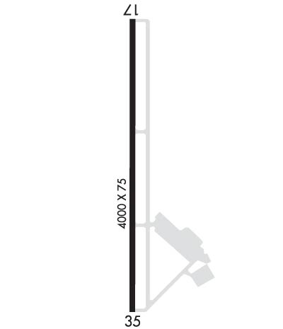
| Lat: N 3034.4 Long: W 09726.6 Elev: 600 Var: -05 Longest Runway: 4000 | ||
| CTAF: 122.8 | ||
| ||||||
|
| Rwy | Rwy | |||||||
| 4000x75 | 4000' | 4000x75 | 3751' | |||||
| Runway ID | Single Wheel | Double Wheel | Double Tandem Wheel | Dual Double Wheel |
| 17/35 | 12,500 | N/A | N/A | N/A |
| These numbers are Advisory and are not limits. The Airport Manager should have more accurate Weight Limits | ||||
 Airport Diagram might not be current. | |
| Facility Name: | TAYLOR MUNI |
| City Name: | TAYLOR |
| County: | WILLIAMSON |
| State abbrev: | TX |
| State Name: | TEXAS |
| Ownership: | PUBLICLY OWNED |
| Use: | OPEN TO THE PUBLIC |
| Owner's Name: | CITY OF TAYLOR |
| Address: | 400 PORTER STREET |
| TAYLOR, TX 76574 | |
| Owner's Phone: | 512-352-3675 |
| Manager's Name: | STACEY BATCH |
| Address: | 303 AIRPORT RD., #101 |
| TAYLOR, TX 76574 | |
| Phone: | 512-352-5747 |
| FAA Region: | SOUTHWEST |
| FAA Field Office: | TEX |
| Date | Sunrise | Sunset |
|---|---|---|
| 04/08/26 Wednesday | 7:11 | 19:53 |
| 04/09/26 Thursday | 7:10 | 19:54 |
| 04/10/26 Friday | 7:08 | 19:54 |
| 04/11/26 Saturday | 7:07 | 19:55 |
| 04/12/26 Sunday | 7:06 | 19:56 |
| 04/13/26 Monday | 7:05 | 19:56 |
| 04/14/26 Tuesday | 7:04 | 19:57 |
| 04/15/26 Wednesday | 7:03 | 19:58 |
| 04/16/26 Thursday | 7:02 | 19:58 |
| 04/17/26 Friday | 7:00 | 19:59 |
| 04/18/26 Saturday | 6:59 | 19:59 |
| 04/19/26 Sunday | 6:58 | 20:00 |
| 04/20/26 Monday | 6:57 | 20:01 |
| 04/21/26 Tuesday | 6:56 | 20:01 |
| Airport Attendance Schedule | MON-FRI 0800-1700 |
| Airport Status | OPERATIONAL (This Status can change at any time - please check NOTAMS) |
| Airport Lighting Schedule | MIRLS RWY 17/35 PRESET LOW SS-SR. TO ACTVT & INCR INTST - CTAF. |
| Airport Storage Available | Tie Downs |
| Extra Services Available | Air Ambulance, Flight Instruction |
| Wind Indicator | YES - (lighted) |
| Control Tower | NO |
| CTAF Frequency | 122.800 |
| Unicom Frequency | 122.800 |
| Rotating Beacon Color | WG |
| Segmented Circle | YES |
| Landing Fee | NO |
| Airport Inspected | STATE - performed by PRIVATE CONTRACT PERSONNEL |
| Inspection Date | 11/17/2025 |
| Type of Fuel Available | Grade 100LL, JET A; -A+100 LL & JET A SELF SERVE ONLY. |
| Airframe Repair Service | MAJOR; HELI SVCS ALSO AVBL. |
| Power Plant Repair Service | MAJOR |
| Latitude | N3034.4 |
| Longitude | W09726.6 (ESTIMATED) |
| Arpt Elevation | 600ft (SURVEYED) |
| Magnetic Variation | 05E |
| 2 miles W | of TAYLOR |
| Traffic Pattern Altitude | |
| Sectional Chart | SAN ANTONIO |
| Operations (Reported) | Yearly | Avg. Daily |
|---|---|---|
| General Aviation Transient | 0 | 0 |
| General Aviation Local | 0 | 0 |
| Air Taxi | 0 | 0 |
| Commerical | 0 | 0 |
| Commuter | 0 | 0 |
| Military | 0 | 0 |
| Aircraft based on Field | |
|---|---|
| General Aviation Singles | 0 |
| General Aviation Multi | 0 |
| Jet Aircraft | 0 |
| General Aviation Helicopters | 0 |
| Military Aircraft | 0 |
| Gliders | 0 |
| Ultralights | 0 |
| FSS on field | NO |
| FSS tie-in | SAN ANGELO |
| FSS Phone | 1-800-WX-BRIEF |
| Who issues Notams | SJT |
| Notam D service at airport | YES |
| ARTCC Name | HOUSTON |
| Airport Certification | |
| Aircraft Rescue & Firefighting Index | None |
| Airport of Entry | No |
| Custom Landing Rights | No |
| Joint Civil/Military | No |
| Military Landing rights | YES |
| NATIONAL PLAN OF INTEGRATED AIRPORT SYSTEMS (NPIAS) |
| SURPLUS PROPERTY AGREEMENT UNDER PUBLIC LAW 289 |
| THIS AIRPORT HAS BEEN SURVEYED BY THE NATIONAL GEODETIC SURVEY. |
| FOR CD CTC AUSTIN APCH AT 512-369-7865. |
| 200 FT. AGL TWR, 1000 FT EAST OF RWY CENTERLINE, APX MID POINT OF RWY. |
| INTSV HEL ACTVTY ON AND INVOF ARPT. |
Airport Communications & Frequencies:
| ||||||||||||||
| Runway: 17 | Runway: 35 | ||
| Mag heading: | 174° | Mag heading: | 354° |
| Rwy Slope: | -1.30% Down | Rwy Slope: | 1.30% Up |
| Approach: | Approach: | ||
| Pattern: | Right Traffic | Pattern: | Left Traffic |
| Markings: | NONPRECISION INSTRUMENT | Markings: | NONPRECISION INSTRUMENT |
| Marking Condition: | FAIR | Marking Condition: | FAIR |
| Arresting Dev: | Arresting Dev: | ||
| Lat & Long: | N3034.7 W09726.6 | Lat. & Long.: | N3034.0 W09726.6 |
| Elev: | 600.0 ft. MSL | Elev: | 547.9 ft. MSL |
| TCH: | 40 ft. AGL | TCH: | 57 ft. AGL |
| Visual Glide Path: | 3.00 degrees | Visual Glide Path: | 3.00 degrees |
| Displaced Threshold: | No | Displaced Threshold: | 249 feet |
| Touchdown Zone: | YES | Touchdown Zone: | YES |
| Touchdown Elev.: | 600.0 feet | Touchdown Elev.: | 585.1 feet |
| Visual Glide Slope: | 2-Light PAPI on LEFT side of Runway | Visual Glide Slope: | 2-Light PAPI on LEFT side of Runway |
| RVR Equipment: | RVR Equipment: | ||
| RVV Equipment: | NO | RVV Equipment: | NO |
| Approach Lights: | Approach Lights: | ||
| REIL: | NO | REIL: | NO |
| Centerline Lights: | NO | Centerline Lights: | NO |
| Touchdown lights: | NO | Touchdown lights: | NO |
| Runway Category: | Runway with a Non-precision Approach | Runway Category: | Runway with a Visual Approach |
| Declared Distances: | Declared Distances: | ||
| Obstructions: | TREES | Obstructions: | TREES |
| Marked: | NOT Marked/Lighted | Marked: | NOT Marked/Lighted |
| Clearance slope: | 27:1 | Clearance slope: | 11:1; APCH RATIO 25:1 TO DSPLCD THR OVR 80 FT TREES 2000 FT DSTC. |
| Obstruction height: | 30 feet AGL | Obstruction height: | 55 feet AGL |
| Dist. from runway: | 1030 feet | Dist. from runway: | 835 feet |
| Centerline offset: | 160 left of centerline | Centerline offset: | 215 feet right of centerline |
| Comments: | Comments: |
Thanks for using FltPlan.com
all rights reserved © 1999-2026 by Flight Plan LLC
