| STATESVILLE RGNL STATESVILLE NC |
| |
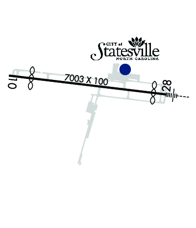
| Lat: N 3545.9 Long: W 08057.2 Elev: 968 Var: +08 Longest Runway: 7003 | ||
| AWOS: 119.22 CTAF: 123.07 | ||
| |||||||||||||||||||||||||||||||
| |||||||||||||||||||||||||||||||
| |||||||||||||||||||||||||||||||
| |||||||||||||||||||||||||||||||
| |||||||||||||||||||||||||||||||
| Rwy | Rwy | |||||||
| 7003x100 | 6005' | 7003x100 | 6453' | 111.75 - 284° | ||||
| Runway ID | Single Wheel | Double Wheel | Double Tandem Wheel | Dual Double Wheel |
| 10/28 | 30,000 | 100,000 | N/A | N/A |
| These numbers are Advisory and are not limits. The Airport Manager should have more accurate Weight Limits | ||||
 Airport Diagram might not be current. | |
| Facility Name: | STATESVILLE RGNL |
| City Name: | STATESVILLE |
| County: | IREDELL |
| State abbrev: | NC |
| State Name: | NORTH CAROLINA |
| Ownership: | PUBLICLY OWNED |
| Use: | OPEN TO THE PUBLIC |
| Owner's Name: | CITY OF STATESVILLE |
| Address: | PO BOX 1111 |
| STATESVILLE, NC 28687 | |
| Owner's Phone: | 704-761-2370 |
| Manager's Name: | JOHN M. FERGUSON |
| Address: | PO BOX 1111 |
| STATESVILLE, NC 28687 | |
| Phone: | 704-761-2370 |
| FAA Region: | SOUTHERN |
| FAA Field Office: | MEM |
| Date | Sunrise | Sunset |
|---|---|---|
| 09/24/21 Friday | 7:13 | 19:18 |
| 09/25/21 Saturday | 7:14 | 19:17 |
| 09/26/21 Sunday | 7:15 | 19:15 |
| 09/27/21 Monday | 7:15 | 19:14 |
| 09/28/21 Tuesday | 7:16 | 19:12 |
| 09/29/21 Wednesday | 7:17 | 19:11 |
| 09/30/21 Thursday | 7:18 | 19:09 |
| 10/01/21 Friday | 7:19 | 19:08 |
| 10/02/21 Saturday | 7:19 | 19:06 |
| 10/03/21 Sunday | 7:20 | 19:05 |
| 10/04/21 Monday | 7:21 | 19:04 |
| 10/05/21 Tuesday | 7:22 | 19:02 |
| 10/06/21 Wednesday | 7:23 | 19:01 |
| 10/07/21 Thursday | 7:23 | 18:59 |
| Airport Attendance Schedule | MON-FRI 0600-2100, SAT-SUN 0800-2100; FOR AFTER HOURS SERVICE CALL (704) 437-6617 OR (704) 880-6897 |
| Airport Status | OPERATIONAL (This Status can change at any time - please check NOTAMS) |
| Airport Lighting Schedule | AFTER SS ACTVT HIRL RWY 10/28; MALSR RWY 28; REIL RWY 10; PAPI RWY 10 & 28 - CTAF. |
| Airport Storage Available | Tie Downs, Hanger |
| Extra Services Available | Charter, Flight Instruction, Aircraft Rental, Aircraft Sales |
| Wind Indicator | YES - (lighted) |
| Control Tower | NO |
| CTAF Frequency | 123.075 |
| Unicom Frequency | 123.075 |
| Rotating Beacon Color | CLEAR-GREEN (Light Land Airport) |
| Segmented Circle | YES |
| Landing Fee | NO |
| Airport Inspected | No Inspection Data Available performed by STATE AERONAUTICAL PERSONNEL |
| Inspection Date | 03/21/2020 |
| Type of Fuel Available | Grade 100LL, JET A (freeze point -40C), JET A-1 (icing inhibitor, freeze point -50C) |
| Airframe Repair Service | MAJOR |
| Power Plant Repair Service | MAJOR |
| Latitude | N3545.9 |
| Longitude | W08057.2 (ESTIMATED) |
| Arpt Elevation | 967ft (SURVEYED) |
| Magnetic Variation | 08W |
| 3 miles SW | of STATESVILLE |
| Traffic Pattern Altitude | |
| Sectional Chart | CHARLOTTE |
| Operations (Reported) | Yearly | Avg. Daily |
|---|---|---|
| General Aviation Transient | 17000 | 47 |
| General Aviation Local | 22000 | 60 |
| Air Taxi | 2000 | 5 |
| Commerical | 0 | 0 |
| Commuter | 0 | 0 |
| Military | 200 | 1 |
| Aircraft based on Field | |
|---|---|
| General Aviation Singles | 44 |
| General Aviation Multi | 19 |
| Jet Aircraft | 29 |
| General Aviation Helicopters | 2 |
| Military Aircraft | 0 |
| Gliders | 0 |
| Ultralights | 0 |
| FSS on field | NO |
| FSS tie-in | RALEIGH |
| FSS Phone | 1-800-WX-BRIEF |
| Who issues Notams | SVH |
| Notam D service at airport | YES |
| ARTCC Name | ATLANTA |
| Airport Certification | |
| Aircraft Rescue & Firefighting Index | None |
| Airport of Entry | No |
| Custom Landing Rights | No |
| Joint Civil/Military | No |
| Military Landing rights | No |
| NATIONAL PLAN OF INTEGRATED AIRPORT SYSTEMS (NPIAS) |
| GRANT AGREEMENTS UNDER FAAP/ADAP/AIP |
| ASSURANCES PURSUANT TO TITLE VI, CIVIL RIGHTS ACT OF 1964 |
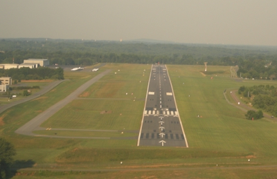
| RY 28 HAS 100 FT DROP-OFF 250 FT RIGHT OF CNTRLN. |
| NO LINE OF SIGHT BTN RYS. |
| FOR AFTER HRS NAVIGATIONAL/LIGHTING FAILURE CALL 704-880-6897. |
| FOR CD CTC ATLANTA ARTCC AT 770-210-7692. |
Airport Communications & Frequencies:
| |||||||||
| Runway: 10 | Runway: 28 | ||
| Mag heading: | 105° | Mag heading: | 285° |
| Rwy Slope: | -.02% Down | Rwy Slope: | .02% Up |
| Approach: | Approach: | ILS/DME | |
| Pattern: | Left Traffic | Pattern: | Left Traffic |
| Markings: | NONPRECISION INSTRUMENT | Markings: | PRECISION INSTRUMENT |
| Marking Condition: | GOOD | Marking Condition: | GOOD |
| Arresting Dev: | Arresting Dev: | ||
| Lat & Long: | N3546.0 W08057.9 | Lat. & Long.: | N3545.8 W08056.5 |
| Elev: | 958.6 ft. MSL | Elev: | 956.9 ft. MSL |
| TCH: | 50 ft. AGL | TCH: | 50 ft. AGL |
| Visual Glide Path: | 3.00 degrees | Visual Glide Path: | 3.00 degrees |
| Displaced Threshold: | 998 feet | Displaced Threshold: | 550 feet |
| Touchdown Zone: | YES | Touchdown Zone: | YES |
| Touchdown Elev.: | 967.8 feet | Touchdown Elev.: | 967.4 feet |
| Visual Glide Slope: | 4-Light PAPI on LEFT side of Runway | Visual Glide Slope: | 4-Light PAPI on LEFT side of Runway |
| RVR Equipment: | RVR Equipment: | ||
| RVV Equipment: | NO | RVV Equipment: | NO |
| Approach Lights: | Approach Lights: | MALSR - 1,400 foot medium intensity approach lighting system with runway alignment indicator lights | |
| REIL: | YES | REIL: | NO |
| Centerline Lights: | NO | Centerline Lights: | NO |
| Touchdown lights: | NO | Touchdown lights: | NO |
| Runway Category: | Runway with a Non-precision Approach having visibility minimums greater than 3/4 mile | Runway Category: | Precision Instrument Runway |
| Declared Distances: | TORA:7006' TODA:7006' ASDA:6456' LDA:5456' | Declared Distances: | TORA:7006' TODA:7006' ASDA:6006' LDA:5456' |
| Obstructions: | TREES | Obstructions: | TREES |
| Marked: | NOT Marked/Lighted | Marked: | NOT Marked/Lighted |
| Clearance slope: | 9:1; APCH SLOPE 24:1 AT DSPLCD THLD, DUE TO +62 FT TREES 1733 FT FM DSPLCD THLD AND OFFSET 586 FT LEFT OF CNTRLN. | Clearance slope: | 19:1; APCH SLOPE 34:1 AT DSPLCD THLD DUE TO +34 FT TREES 1356 FT FM DSPLCD THLD AND 47 FT RIGHT OF CNTRLN. |
| Obstruction height: | 51 feet AGL | Obstruction height: | 32 feet AGL |
| Dist. from runway: | 704 feet | Dist. from runway: | 813 feet |
| Centerline offset: | 440 left of centerline | Centerline offset: | |
| Comments: | Comments: |
Thanks for using FltPlan.com
all rights reserved © 1999-2021 by Flight Plan LLC