
| SCAPPOOSE INDUSTRIAL AIRPARK SCAPPOOSE OR |
| |
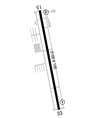
| Lat: N 4546.3 Long: W 12251.7 Elev: 58 Var: -17 Longest Runway: 5100 | ||
| Clr Del: 121.65 AWOS: 135.87 CTAF: 122.8 | ||
| ||||||||||||||||||||||||||||||||
| ||||||||||||||||||||||||||||||||
| ||||||||||||||||||||||||||||||||
| ||||||||||||||||||||||||||||||||
| Rwy | Rwy | |||||||
| 5100x100 | 5100' | 111.10 - 151° | 5100x100 | 5100' | ||||
| Runway ID | Single Wheel | Double Wheel | Double Tandem Wheel | Dual Double Wheel |
| 15/33 | 30,000 | 50,000 | 90,000 | N/A |
| These numbers are Advisory and are not limits. The Airport Manager should have more accurate Weight Limits | ||||
 Airport Diagram might not be current. | |
| Facility Name: | SCAPPOOSE |
| City Name: | SCAPPOOSE |
| County: | COLUMBIA |
| State abbrev: | OR |
| State Name: | OREGON |
| Ownership: | PUBLICLY OWNED |
| Use: | OPEN TO THE PUBLIC |
| Owner's Name: | PORT OF COLUMBIA COUNTY |
| Address: | PO BOX 190 |
| COLUMBIA CITY, OR 97018 | |
| Owner's Phone: | 503-397-2888 |
| Manager's Name: | CRAIG ALLISON |
| Address: | PO BOX 190 |
| COLUMBIA CITY, OR 97018 | |
| Phone: | 503-397-2888 |
| FAA Region: | NORTHWEST MOUNTAIN |
| FAA Field Office: | SEA |
| Date | Sunrise | Sunset |
|---|---|---|
| 09/24/21 Friday | 7:01 | 19:05 |
| 09/25/21 Saturday | 7:02 | 19:03 |
| 09/26/21 Sunday | 7:03 | 19:01 |
| 09/27/21 Monday | 7:04 | 19:00 |
| 09/28/21 Tuesday | 7:06 | 18:58 |
| 09/29/21 Wednesday | 7:07 | 18:56 |
| 09/30/21 Thursday | 7:08 | 18:54 |
| 10/01/21 Friday | 7:10 | 18:52 |
| 10/02/21 Saturday | 7:11 | 18:50 |
| 10/03/21 Sunday | 7:12 | 18:48 |
| 10/04/21 Monday | 7:13 | 18:46 |
| 10/05/21 Tuesday | 7:15 | 18:44 |
| 10/06/21 Wednesday | 7:16 | 18:42 |
| 10/07/21 Thursday | 7:17 | 18:40 |
| Airport Attendance Schedule | 7 Days A Week 0800-DUSK |
| Airport Status | OPERATIONAL (This Status can change at any time - please check NOTAMS) |
| Airport Lighting Schedule | ACTVT REIL RWY 15; PAPI RWY 15 AND 33; MIRL RWY 15/33; - CTAF. 7 CLICKS TO ACTVT REIL. |
| Airport Storage Available | Tie Downs |
| Extra Services Available | Crop Dusting, Flight Instruction, Aircraft Rental |
| Wind Indicator | YES - (lighted) |
| Control Tower | NO |
| CTAF Frequency | 122.800 |
| Unicom Frequency | 122.800 |
| Rotating Beacon Color | CLEAR-GREEN (Light Land Airport) |
| Segmented Circle | YES |
| Landing Fee | NO |
| Airport Inspected | STATE - performed by STATE AERONAUTICAL PERSONNEL |
| Inspection Date | 09/18/2018 |
| Type of Fuel Available | Grade 100LL, JET A (freeze point -40C) |
| Airframe Repair Service | MAJOR |
| Power Plant Repair Service | MAJOR |
| Latitude | N4546.3 |
| Longitude | W12251.7 (ESTIMATED) |
| Arpt Elevation | 58ft (SURVEYED) |
| Magnetic Variation | 17E |
| 1 miles NE | of SCAPPOOSE |
| Traffic Pattern Altitude | |
| Sectional Chart | SEATTLE |
| Operations (Reported) | Yearly | Avg. Daily |
|---|---|---|
| General Aviation Transient | 33500 | 92 |
| General Aviation Local | 23400 | 64 |
| Air Taxi | 2500 | 7 |
| Commerical | 0 | 0 |
| Commuter | 0 | 0 |
| Military | 600 | 2 |
| Aircraft based on Field | |
|---|---|
| General Aviation Singles | 103 |
| General Aviation Multi | 3 |
| Jet Aircraft | 0 |
| General Aviation Helicopters | 5 |
| Military Aircraft | 0 |
| Gliders | 2 |
| Ultralights | 0 |
| FSS on field | NO |
| FSS tie-in | MC MINNVILLE |
| FSS Phone | 1-800-WX-BRIEF |
| Who issues Notams | SPB |
| Notam D service at airport | YES |
| ARTCC Name | SEATTLE |
| Airport Certification | |
| Aircraft Rescue & Firefighting Index | None |
| Airport of Entry | No |
| Custom Landing Rights | No |
| Joint Civil/Military | No |
| Military Landing rights | YES |
| NATIONAL PLAN OF INTEGRATED AIRPORT SYSTEMS (NPIAS) |
| GRANT AGREEMENTS UNDER FAAP/ADAP/AIP |
| ASSURANCES PURSUANT TO TITLE VI, CIVIL RIGHTS ACT OF 1964 |
| AGREEMENT UNDER DLAND OR DCLA HAS EXPIRED. |
| THIS AIRPORT HAS BEEN SURVEYED BY THE NATIONAL GEODETIC SURVEY. |
| BLUE LGTS & CNTRLN REFLECTORS AT EAST SIDE TWY EXITS FM RWY. |
| EXTENSIVE ULTRALIGHT ACTIVITY ON WEST SIDE PARALLEL TWY. |
| RUNWAY 33 HAS BASIC MARKINGS PLUS AIMING POINTS |
| TWY B HAS MED INTST TWY LGTS. |
| FOR CD CTC PORTLAND APPROACH AT 503-493-7545. |
| RWY 15 IS CALM WND RWY |
Airport Communications & Frequencies:
| ||||||||||||||||
| Runway: 15 | Runway: 33 | ||
| Mag heading: | 152° | Mag heading: | 332° |
| Rwy Slope: | -.55% Down | Rwy Slope: | .55% Up |
| Approach: | LOC/DME | Approach: | |
| Pattern: | Left Traffic | Pattern: | Right Traffic |
| Markings: | NONPRECISION INSTRUMENT | Markings: | NONPRECISION INSTRUMENT |
| Marking Condition: | FAIR | Marking Condition: | GOOD |
| Arresting Dev: | Arresting Dev: | ||
| Lat & Long: | N4546.7 W12251.8 | Lat. & Long.: | N4545.9 W12251.6 |
| Elev: | 58.1 ft. MSL | Elev: | 30.0 ft. MSL |
| TCH: | 41 ft. AGL | TCH: | 40 ft. AGL |
| Visual Glide Path: | 3.73 degrees | Visual Glide Path: | 3.00 degrees |
| Displaced Threshold: | No | Displaced Threshold: | No |
| Touchdown Zone: | YES | Touchdown Zone: | YES |
| Touchdown Elev.: | 58.1 feet | Touchdown Elev.: | 50.8 feet |
| Visual Glide Slope: | 4-Light PAPI on LEFT side of Runway | Visual Glide Slope: | 4-Light PAPI on LEFT side of Runway |
| RVR Equipment: | RVR Equipment: | ||
| RVV Equipment: | NO | RVV Equipment: | NO |
| Approach Lights: | Approach Lights: | ||
| REIL: | YES | REIL: | NO |
| Centerline Lights: | NO | Centerline Lights: | NO |
| Touchdown lights: | NO | Touchdown lights: | NO |
| Runway Category: | Runway with a Non-precision Approach having visibility minimums greater than 3/4 mile | Runway Category: | Runway with a Visual Approach |
| Declared Distances: | Declared Distances: | ||
| Obstructions: | TREE | Obstructions: | |
| Marked: | NOT Marked/Lighted | Marked: | |
| Clearance slope: | 5:1 | Clearance slope: | 50:1 |
| Obstruction height: | 49 feet AGL | Obstruction height: | |
| Dist. from runway: | 477 feet | Dist. from runway: | |
| Centerline offset: | 325 right of centerline | Centerline offset: | |
| Comments: | Comments: |
Thanks for using FltPlan.com
all rights reserved © 1999-2021 by Flight Plan LLC
