
| STUTTGART MUNI STUTTGART AR |
| |
| Lat: N 3436.0 Long: W 09134.5 Elev: 224 Var: -02 Longest Runway: 6015 | ||
| Clr Del: 123.7 AWOS: 119.02 CTAF: 122.8 | ||
| ||||||
| ||||||
|
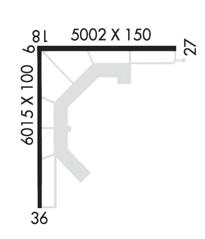
| Rwy | Rwy | |||||||
| 5002x150 | 5002' | 5002x150 | 5002' | |||||
| 6015x100 | 6015' | 6015x100 | 6015' | 110.55 - 359° | ||||
| Runway ID | Single Wheel | Double Wheel | Double Tandem Wheel | Dual Double Wheel |
| 09/27 | 25,000 | 65,000 | 120,000 | N/A |
| 18/36 | 75,000 | 150,000 | 200,000 | 300,000 |
| These numbers are Advisory and are not limits. The Airport Manager should have more accurate Weight Limits | ||||
 Airport Diagram might not be current. | |
| Facility Name: | STUTTGART MUNI CARL HUMPHREY FLD |
| City Name: | STUTTGART |
| County: | PRAIRIE |
| State abbrev: | AR |
| State Name: | ARKANSAS |
| Ownership: | PUBLICLY OWNED |
| Use: | OPEN TO THE PUBLIC |
| Owner's Name: | CITY OF STUTTGART |
| Address: | 304 S. MAPLE |
| STUTTGART, AR 72160 | |
| Owner's Phone: | 870-673-3535 |
| Manager's Name: | ANTHONY TIBBETT |
| Address: | 2000 AIRPORT RD TERMINAL BLD |
| STUTTGART, AR 72160 | |
| Phone: | 870-673-2960; AIRPORTMANAGER@STUTTGARTAR.COM |
| FAA Region: | SOUTHWEST |
| FAA Field Office: | AOK |
| Date | Sunrise | Sunset |
|---|---|---|
| 02/16/26 Monday | 6:51 | 17:50 |
| 02/17/26 Tuesday | 6:50 | 17:51 |
| 02/18/26 Wednesday | 6:49 | 17:52 |
| 02/19/26 Thursday | 6:48 | 17:53 |
| 02/20/26 Friday | 6:47 | 17:54 |
| 02/21/26 Saturday | 6:45 | 17:55 |
| 02/22/26 Sunday | 6:44 | 17:56 |
| 02/23/26 Monday | 6:43 | 17:57 |
| 02/24/26 Tuesday | 6:42 | 17:58 |
| 02/25/26 Wednesday | 6:41 | 17:59 |
| 02/26/26 Thursday | 6:40 | 18:00 |
| 02/27/26 Friday | 6:38 | 18:00 |
| 02/28/26 Saturday | 6:37 | 18:01 |
| 03/01/26 Sunday | 6:36 | 18:02 |
| Airport Attendance Schedule | NOV-JAN 7 Days A Week 0800-2000, FEB-OCT MON-FRI 0800-1600 |
| Airport Status | OPERATIONAL (This Status can change at any time - please check NOTAMS) |
| Airport Lighting Schedule | ACTVT MALSF RWY 36; REIL RWY 18 & 27; MIRL RWYS 09/27 & 18/36 - CTAF. |
| Airport Storage Available | Tie Downs |
| Extra Services Available | Crop Dusting |
| Wind Indicator | YES - (unlit) |
| Control Tower | NO |
| CTAF Frequency | 122.800 |
| Unicom Frequency | 122.800 |
| Rotating Beacon Color | WG |
| Segmented Circle | YES |
| Landing Fee | NO |
| Airport Inspected | STATE - performed by STATE AERONAUTICAL PERSONNEL |
| Inspection Date | 07/19/2024 |
| Type of Fuel Available | Grade 100LL, JET A (freeze point -40C); -10100LL AVBL 24 HRS SELF-SERVE WITH CREDIT CARD. FOR FUEL NGTS CALL 870-672-2005. |
| Airframe Repair Service | NONE |
| Power Plant Repair Service | NONE |
| Latitude | N3436.0 |
| Longitude | W09134.5 (ESTIMATED) |
| Arpt Elevation | 224ft (SURVEYED) |
| Magnetic Variation | 02E |
| 7 miles N | of STUTTGART |
| Traffic Pattern Altitude | |
| Sectional Chart | MEMPHIS |
| Operations (Reported) | Yearly | Avg. Daily |
|---|---|---|
| General Aviation Transient | 0 | 0 |
| General Aviation Local | 0 | 0 |
| Air Taxi | 0 | 0 |
| Commerical | 0 | 0 |
| Commuter | 0 | 0 |
| Military | 0 | 0 |
| Aircraft based on Field | |
|---|---|
| General Aviation Singles | 0 |
| General Aviation Multi | 0 |
| Jet Aircraft | 0 |
| General Aviation Helicopters | 0 |
| Military Aircraft | 0 |
| Gliders | 0 |
| Ultralights | 0 |
| FSS on field | NO |
| FSS tie-in | JONESBORO |
| FSS Phone | 1-800-WX-BRIEF |
| Who issues Notams | SGT |
| Notam D service at airport | YES |
| ARTCC Name | MEMPHIS |
| Airport Certification | |
| Aircraft Rescue & Firefighting Index | None |
| Airport of Entry | No |
| Custom Landing Rights | No |
| Joint Civil/Military | No |
| Military Landing rights | YES |
| NATIONAL PLAN OF INTEGRATED AIRPORT SYSTEMS (NPIAS) |
| GRANT AGREEMENTS UNDER FAAP/ADAP/AIP |
| ASSURANCES PURSUANT TO TITLE VI, CIVIL RIGHTS ACT OF 1964 |
| MIGRATORY BIRDS ON & INVOF ARPT NOV-FEB. |
| NMRS AGRICULTURAL ACFT OPNS FM FEB-SEP 500 FT AGL AND BLW. |
| FOR CD WHEN UNA VIA FREQ CTC LITTLE ROCK APCH 501-379-2908 OR LITTLE ROCK ATCT 501-379-2911 |
| FOR SVC AFT HRS CALL 870-672-2005. |
Airport Communications & Frequencies:
| ||||||||||||||||
| Runway: 09 | Runway: 27 | ||
| Mag heading: | 90° | Mag heading: | 270° |
| Rwy Slope: | -.02% Down | Rwy Slope: | .02% Up |
| Approach: | Approach: | ||
| Pattern: | Left Traffic | Pattern: | Left Traffic |
| Markings: | BASIC | Markings: | BASIC |
| Marking Condition: | FAIR; RWY NR FADED. | Marking Condition: | FAIR; RWY NR FADED. |
| Arresting Dev: | Arresting Dev: | ||
| Lat & Long: | N3436.2 W09134.7 | Lat. & Long.: | N3436.2 W09133.7 |
| Elev: | 219.6 ft. MSL | Elev: | 218.6 ft. MSL |
| TCH: | TCH: | ||
| Visual Glide Path: | Visual Glide Path: | ||
| Displaced Threshold: | No | Displaced Threshold: | No |
| Touchdown Zone: | YES | Touchdown Zone: | YES |
| Touchdown Elev.: | 222.2 feet | Touchdown Elev.: | 222.2 feet |
| Visual Glide Slope: | Visual Glide Slope: | ||
| RVR Equipment: | RVR Equipment: | ||
| RVV Equipment: | NO | RVV Equipment: | NO |
| Approach Lights: | Approach Lights: | ||
| REIL: | NO | REIL: | YES |
| Centerline Lights: | NO | Centerline Lights: | NO |
| Touchdown lights: | NO | Touchdown lights: | NO |
| Runway Category: | Runway with a Visual Approach | Runway Category: | Runway with a Visual Approach |
| Declared Distances: | Declared Distances: |
| Runway: 18 | Runway: 36 | ||
| Mag heading: | 180° | Mag heading: | 0° |
| Rwy Slope: | .04% Up | Rwy Slope: | -.04% Down |
| Approach: | Approach: | ILS/DME | |
| Pattern: | Left Traffic | Pattern: | Left Traffic |
| Markings: | PRECISION INSTRUMENT | Markings: | PRECISION INSTRUMENT |
| Marking Condition: | GOOD | Marking Condition: | GOOD |
| Arresting Dev: | Arresting Dev: | ||
| Lat & Long: | N3436.3 W09134.7 | Lat. & Long.: | N3435.3 W09134.7 |
| Elev: | 220.1 ft. MSL | Elev: | 222.8 ft. MSL |
| TCH: | TCH: | ||
| Visual Glide Path: | Visual Glide Path: | ||
| Displaced Threshold: | No | Displaced Threshold: | No |
| Touchdown Zone: | YES | Touchdown Zone: | YES |
| Touchdown Elev.: | 224.4 feet | Touchdown Elev.: | 224.1 feet |
| Visual Glide Slope: | Visual Glide Slope: | ||
| RVR Equipment: | RVR Equipment: | ||
| RVV Equipment: | NO | RVV Equipment: | NO |
| Approach Lights: | Approach Lights: | MALSF - 1,400 foot medium intensity approach lighting system with sequenced flashers | |
| REIL: | YES | REIL: | NO |
| Centerline Lights: | NO | Centerline Lights: | NO |
| Touchdown lights: | NO | Touchdown lights: | NO |
| Runway Category: | Runway with a Non-precision Approach having visibility minimums greater than 3/4 mile | Runway Category: | Runway with a Non-precision Approach having visibility minimums greater than 3/4 mile |
| Declared Distances: | Declared Distances: |
Thanks for using FltPlan.com
all rights reserved © 1999-2026 by Flight Plan LLC
