
| RENO/STEAD RENO NV |
| |
| Lat: N 3940.1 Long: W 11952.6 Elev: 5050 Var: -16 Longest Runway: 9000 | ||
| AWOS: 135.17 CTAF: 122.7 | ||
| |||||||||||||||||||||||||||||||||||||||||||||||||||||||||||||||||||||
| |||||||||||||||||||||||||||||||||||||||||||||||||||||||||||||||||||||
| |||||||||||||||||||||||||||||||||||||||||||||||||||||||||||||||||||||
| |||||||||||||||||||||||||||||||||||||||||||||||||||||||||||||||||||||
| |||||||||||||||||||||||||||||||||||||||||||||||||||||||||||||||||||||
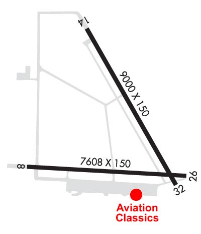
| Rwy | Rwy | |||||||
| 7608x150 | 7608' | 7608x150 | 7608' | |||||
| 9000x150 | 9000' | 9000x150 | 7800' | 111.90 - 317° | ||||
| Runway ID | Single Wheel | Double Wheel | Double Tandem Wheel | Dual Double Wheel |
| 08/26 | N/A | N/A | N/A | N/A |
| 14/32 | N/A | N/A | N/A | N/A |
| These numbers are Advisory and are not limits. The Airport Manager should have more accurate Weight Limits | ||||
 Airport Diagram might not be current. | |
| Facility Name: | RENO/STEAD |
| City Name: | RENO |
| County: | WASHOE |
| State abbrev: | NV |
| State Name: | NEVADA |
| Ownership: | PUBLICLY OWNED |
| Use: | OPEN TO THE PUBLIC |
| Owner's Name: | RENO TAHOE ARPT AUTH |
| Address: | P.O. BOX 12490 |
| RENO, NV 89510 | |
| Owner's Phone: | 775-328-6400 |
| Manager's Name: | MIKE SCOTT; OTR CTC: MIKE SCOTT, MSCOTT@RENOAIRPORT.COM; SUPERVISOR: RFOOTE@RENOAIRPORT.COM |
| Address: | 4895 TEXAS AVE |
| RENO, NV 89506 | |
| Phone: | 775-328-6573 |
| FAA Region: | WESTERN-PACIFIC |
| FAA Field Office: | PHX |
| Date | Sunrise | Sunset |
|---|---|---|
| 09/24/21 Friday | 6:49 | 18:54 |
| 09/25/21 Saturday | 6:50 | 18:52 |
| 09/26/21 Sunday | 6:51 | 18:50 |
| 09/27/21 Monday | 6:52 | 18:49 |
| 09/28/21 Tuesday | 6:53 | 18:47 |
| 09/29/21 Wednesday | 6:54 | 18:45 |
| 09/30/21 Thursday | 6:55 | 18:44 |
| 10/01/21 Friday | 6:56 | 18:42 |
| 10/02/21 Saturday | 6:56 | 18:41 |
| 10/03/21 Sunday | 6:57 | 18:39 |
| 10/04/21 Monday | 6:58 | 18:37 |
| 10/05/21 Tuesday | 6:59 | 18:36 |
| 10/06/21 Wednesday | 7:00 | 18:34 |
| 10/07/21 Thursday | 7:01 | 18:33 |
| Airport Attendance Schedule | MONDAY - FRIDAY 0700-1630 |
| Airport Status | OPERATIONAL (This Status can change at any time - please check NOTAMS) |
| Airport Lighting Schedule | 1700-0900 ACTVT HIRL RWY 08/26 & 14/32 - CTAF. |
| Airport Storage Available | Tie Downs, Hanger |
| Extra Services Available | Air Freight, Air Ambulance, Avionics, Glider, Flight Instruction, Parachute Jumping, Aircraft Rental, Glider Towing |
| Wind Indicator | YES - (lighted) |
| Control Tower | NO |
| CTAF Frequency | 122.700 |
| Unicom Frequency | 122.700 |
| Rotating Beacon Color | CLEAR-GREEN (Light Land Airport) |
| Segmented Circle | YES |
| Landing Fee | NO |
| Airport Inspected | STATE - performed by STATE AERONAUTICAL PERSONNEL |
| Inspection Date | 08/24/2020 |
| Type of Fuel Available | Grade 100LL, JET A (freeze point -40C) |
| Airframe Repair Service | MAJOR |
| Power Plant Repair Service | MAJOR |
| Latitude | N3940.1 |
| Longitude | W11952.6 (ESTIMATED) |
| Arpt Elevation | 5050ft (SURVEYED) |
| Magnetic Variation | 16E |
| 10 miles NW | of RENO |
| Traffic Pattern Altitude | 800; TPA-6246(1200) HEAVY/HIGH PERFORMANCE ACFT. |
| Sectional Chart | SAN FRANCISCO |
| Operations (Reported) | Yearly | Avg. Daily |
|---|---|---|
| General Aviation Transient | 14340 | 39 |
| General Aviation Local | 23141 | 63 |
| Air Taxi | 0 | 0 |
| Commerical | 0 | 0 |
| Commuter | 0 | 0 |
| Military | 6719 | 18 |
| Aircraft based on Field | |
|---|---|
| General Aviation Singles | 143 |
| General Aviation Multi | 6 |
| Jet Aircraft | 17 |
| General Aviation Helicopters | 6 |
| Military Aircraft | 16 |
| Gliders | 1 |
| Ultralights | 0 |
| FSS on field | NO |
| FSS tie-in | RENO |
| FSS Phone | 1-800-WX-BRIEF |
| Who issues Notams | RTS |
| Notam D service at airport | YES |
| ARTCC Name | OAKLAND |
| Airport Certification | |
| Aircraft Rescue & Firefighting Index | None |
| Airport of Entry | No |
| Custom Landing Rights | No |
| Joint Civil/Military | No |
| Military Landing rights | YES |
| NATIONAL PLAN OF INTEGRATED AIRPORT SYSTEMS (NPIAS) |
| GRANT AGREEMENTS UNDER FAAP/ADAP/AIP |
| SURPLUS PROPERTY AGREEMENT UNDER PUBLIC LAW 289 |
| ASSURANCES PURSUANT TO TITLE VI, CIVIL RIGHTS ACT OF 1964 |
| FOR CD CTC NORCAL APCH AT 916-361-0596. |
| FBO ATTENDANT ON CALL 24 HRS 775-530-7164 AND FREQ 122.775 FOR FUEL. |
| EXTSV ARMY GUARD HEL OPNS INVOF ARPT. |
| BE ALERT FOR BALLOON TRAFFIC NW QUADRANT OF ARPT. |
| EXTSV TANKER & FIRE ATTACK OPS DRG FIRE SEASON. |
| COLD TEMPERATURE AIRPORT. ALTITUDE CORRECTION REQUIRED AT OR BELOW -16C. |
Airport Communications & Frequencies:
| ||||||||||||||
| Runway: 08 | Runway: 26 | ||
| Mag heading: | 80° | Mag heading: | 260° |
| Rwy Slope: | .77% Up | Rwy Slope: | -.77% Down |
| Approach: | Approach: | ||
| Pattern: | Left Traffic | Pattern: | Right Traffic |
| Markings: | NONPRECISION INSTRUMENT | Markings: | NONPRECISION INSTRUMENT |
| Marking Condition: | GOOD | Marking Condition: | GOOD |
| Arresting Dev: | Arresting Dev: | ||
| Lat & Long: | N3939.9 W11953.5 | Lat. & Long.: | N3939.7 W11951.9 |
| Elev: | 4991.8 ft. MSL | Elev: | 5050.1 ft. MSL |
| TCH: | 45 ft. AGL | TCH: | 46 ft. AGL |
| Visual Glide Path: | 4.00 degrees | Visual Glide Path: | 3.00 degrees |
| Displaced Threshold: | No | Displaced Threshold: | No |
| Touchdown Zone: | YES | Touchdown Zone: | YES |
| Touchdown Elev.: | 5014.1 feet | Touchdown Elev.: | 5050.1 feet |
| Visual Glide Slope: | 4-Light PAPI on LEFT side of Runway; PAPI UNUSBL BYD 5 DEGS RIGHT OF CNTRLN. | Visual Glide Slope: | 4-Light PAPI on LEFT side of Runway |
| RVR Equipment: | RVR Equipment: | ||
| RVV Equipment: | NO | RVV Equipment: | NO |
| Approach Lights: | Approach Lights: | ||
| REIL: | YES | REIL: | YES |
| Centerline Lights: | NO | Centerline Lights: | NO |
| Touchdown lights: | NO | Touchdown lights: | NO |
| Runway Category: | Runway with a Visual Approach | Runway Category: | Runway with a Visual Approach |
| Declared Distances: | TORA:6956' TODA:6956' LDA:6956' | Declared Distances: | LDA:7294' |
| Runway: 14 | Runway: 32 | ||
| Mag heading: | 137° | Mag heading: | 317° |
| Rwy Slope: | .00% Up | Rwy Slope: | .00% Down |
| Approach: | Approach: | ILS/DME | |
| Pattern: | Left Traffic | Pattern: | Right Traffic |
| Markings: | NONPRECISION INSTRUMENT | Markings: | NONPRECISION INSTRUMENT |
| Marking Condition: | GOOD | Marking Condition: | GOOD |
| Arresting Dev: | Arresting Dev: | ||
| Lat & Long: | N3941.0 W11952.9 | Lat. & Long.: | N3939.7 W11952.0 |
| Elev: | 5043.5 ft. MSL | Elev: | 5043.8 ft. MSL |
| TCH: | 40 ft. AGL | TCH: | 39 ft. AGL |
| Visual Glide Path: | 3.00 degrees | Visual Glide Path: | 3.00 degrees |
| Displaced Threshold: | No | Displaced Threshold: | 1200 feet |
| Touchdown Zone: | YES | Touchdown Zone: | YES |
| Touchdown Elev.: | 5043.5 feet | Touchdown Elev.: | 5044.8 feet |
| Visual Glide Slope: | 4-Light PAPI on LEFT side of Runway; PAPI OTS INDEFLY. | Visual Glide Slope: | 4-Light PAPI on LEFT side of Runway |
| RVR Equipment: | RVR Equipment: | ||
| RVV Equipment: | NO | RVV Equipment: | NO |
| Approach Lights: | Approach Lights: | MALSR - 1,400 foot medium intensity approach lighting system with runway alignment indicator lights | |
| REIL: | YES | REIL: | YES |
| Centerline Lights: | NO | Centerline Lights: | NO |
| Touchdown lights: | NO | Touchdown lights: | NO |
| Runway Category: | Runway with a Visual Approach | Runway Category: | Precision Instrument Runway |
| Declared Distances: | Declared Distances: | LDA:7800' |
Thanks for using FltPlan.com
all rights reserved © 1999-2021 by Flight Plan LLC


