
| MERRILL MUNI MERRILL WI |
| |
| Lat: N 4511.9 Long: W 08942.8 Elev: 1318 Var: +01 Longest Runway: 5101 | ||
| Clr Del: 121.72 GCO AWOS: 119.92 CTAF: 122.8 | ||
| ||||||||||||||||||||||||||||||||||||||||||||||||||||||||||||||||||||
| ||||||||||||||||||||||||||||||||||||||||||||||||||||||||||||||||||||
| ||||||||||||||||||||||||||||||||||||||||||||||||||||||||||||||||||||
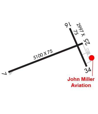
| Rwy | Rwy | |||||||
| 5101x75 | 5101' | 5101x75 | 5101' | |||||
| 2997x75 | 2997' | 2997x75 | 2997' | |||||
| Runway ID | Single Wheel | Double Wheel | Double Tandem Wheel | Dual Double Wheel |
| 07/25 | 45,000 | 65,000 | 100,000 | N/A |
| 16/34 | 26,000 | N/A | N/A | N/A |
| These numbers are Advisory and are not limits. The Airport Manager should have more accurate Weight Limits | ||||
 Airport Diagram might not be current. | |
| Facility Name: | MERRILL MUNI |
| City Name: | MERRILL |
| County: | LINCOLN |
| State abbrev: | WI |
| State Name: | WISCONSIN |
| Ownership: | PUBLICLY OWNED |
| Use: | OPEN TO THE PUBLIC |
| Owner's Name: | CITY OF MERRILL |
| Address: | N2241 AIRPORT RD |
| MERRILL, WI 54452 | |
| Owner's Phone: | 715-536-2024 |
| Manager's Name: | RICH MCCULLOUGH |
| Address: | N2241 AIRPORT RD |
| MERRILL, WI 54452 | |
| Phone: | 715-536-2024 |
| FAA Region: | GREAT LAKES |
| FAA Field Office: | CHI |
| Date | Sunrise | Sunset |
|---|---|---|
| 10/11/25 Saturday | 7:09 | 18:21 |
| 10/12/25 Sunday | 7:11 | 18:19 |
| 10/13/25 Monday | 7:12 | 18:18 |
| 10/14/25 Tuesday | 7:13 | 18:16 |
| 10/15/25 Wednesday | 7:14 | 18:14 |
| 10/16/25 Thursday | 7:16 | 18:12 |
| 10/17/25 Friday | 7:17 | 18:11 |
| 10/18/25 Saturday | 7:18 | 18:09 |
| 10/19/25 Sunday | 7:20 | 18:07 |
| 10/20/25 Monday | 7:21 | 18:06 |
| 10/21/25 Tuesday | 7:22 | 18:04 |
| 10/22/25 Wednesday | 7:24 | 18:02 |
| 10/23/25 Thursday | 7:25 | 18:01 |
| 10/24/25 Friday | 7:26 | 17:59 |
| Airport Attendance Schedule | MON-SAT 0800-1700 |
| Airport Status | OPERATIONAL (This Status can change at any time - please check NOTAMS) |
| Airport Lighting Schedule | MIRL RWY 07/25 PRESET TO LOW SS-SR; TO INCR INTST & ACTVT REIL RWY 07 & 25; PAPI RWY 07 & 25; MIRL RWY 16/34; - CTAF. |
| Airport Storage Available | Tie Downs, Hanger |
| Extra Services Available | Flight Instruction, Aircraft Rental |
| Wind Indicator | YES - (lighted) |
| Control Tower | NO |
| CTAF Frequency | 122.800 |
| Unicom Frequency | 122.800 |
| Rotating Beacon Color | WG |
| Segmented Circle | YES |
| Landing Fee | NO |
| Airport Inspected | STATE - performed by STATE AERONAUTICAL PERSONNEL |
| Inspection Date | 06/22/2023 |
| Type of Fuel Available | Grade 100LL, JET A; -10FUEL AVBL H24 VIA CREDIT CARD. |
| Airframe Repair Service | MAJOR |
| Power Plant Repair Service | MINOR |
| Latitude | N4511.9 |
| Longitude | W08942.8 (ESTIMATED) |
| Arpt Elevation | 1318ft (SURVEYED) |
| Magnetic Variation | 01W |
| 1 miles NW | of MERRILL |
| Traffic Pattern Altitude | |
| Sectional Chart | GREEN BAY |
| Operations (Reported) | Yearly | Avg. Daily |
|---|---|---|
| General Aviation Transient | 0 | 0 |
| General Aviation Local | 0 | 0 |
| Air Taxi | 0 | 0 |
| Commerical | 0 | 0 |
| Commuter | 0 | 0 |
| Military | 0 | 0 |
| Aircraft based on Field | |
|---|---|
| General Aviation Singles | 0 |
| General Aviation Multi | 0 |
| Jet Aircraft | 0 |
| General Aviation Helicopters | 0 |
| Military Aircraft | 0 |
| Gliders | 0 |
| Ultralights | 0 |
| FSS on field | NO |
| FSS tie-in | GREEN BAY |
| FSS Phone | 1-800-WX-BRIEF |
| Who issues Notams | RRL |
| Notam D service at airport | YES |
| ARTCC Name | MINNEAPOLIS |
| Airport Certification | |
| Aircraft Rescue & Firefighting Index | None |
| Airport of Entry | No |
| Custom Landing Rights | No |
| Joint Civil/Military | No |
| Military Landing rights | YES |
| NATIONAL PLAN OF INTEGRATED AIRPORT SYSTEMS (NPIAS) |
| GRANT AGREEMENTS UNDER FAAP/ADAP/AIP |
| ASSURANCES PURSUANT TO TITLE VI, CIVIL RIGHTS ACT OF 1964 |
| ULTRALIGHT ACT ON & INVOF ARPT. |
| FOR CD CTC MINNEAPOLIS ARTCC AT 651-463-5588. |
Airport Communications & Frequencies:
| |||||||||
| Runway: 07 | Runway: 25 | ||
| Mag heading: | 70° | Mag heading: | 250° |
| Rwy Slope: | -.23% Down | Rwy Slope: | .23% Up |
| Approach: | Approach: | ||
| Pattern: | Left Traffic | Pattern: | Left Traffic |
| Markings: | NONPRECISION INSTRUMENT | Markings: | NONPRECISION INSTRUMENT |
| Marking Condition: | GOOD | Marking Condition: | GOOD |
| Arresting Dev: | Arresting Dev: | ||
| Lat & Long: | N4511.7 W08943.5 | Lat. & Long.: | N4512.1 W08942.4 |
| Elev: | 1318.1 ft. MSL | Elev: | 1306.2 ft. MSL |
| TCH: | 40 ft. AGL | TCH: | 40 ft. AGL |
| Visual Glide Path: | 3.00 degrees | Visual Glide Path: | 3.00 degrees |
| Displaced Threshold: | No | Displaced Threshold: | No |
| Touchdown Zone: | YES | Touchdown Zone: | YES |
| Touchdown Elev.: | 1318.2 feet | Touchdown Elev.: | 1310.6 feet |
| Visual Glide Slope: | 2-Light PAPI on LEFT side of Runway | Visual Glide Slope: | 2-Light PAPI on LEFT side of Runway |
| RVR Equipment: | RVR Equipment: | ||
| RVV Equipment: | NO | RVV Equipment: | NO |
| Approach Lights: | Approach Lights: | ||
| REIL: | YES | REIL: | YES |
| Centerline Lights: | NO | Centerline Lights: | NO |
| Touchdown lights: | NO | Touchdown lights: | NO |
| Runway Category: | Runway with a Non-precision Approach having visibility minimums greater than 3/4 mile | Runway Category: | Runway with a Non-precision Approach having visibility minimums greater than 3/4 mile |
| Declared Distances: | Declared Distances: | ||
| Obstructions: | TREES | Obstructions: | TREES |
| Marked: | NOT Marked/Lighted | Marked: | NOT Marked/Lighted |
| Clearance slope: | 25:1 | Clearance slope: | 23:1 |
| Obstruction height: | 55 feet AGL | Obstruction height: | 35 feet AGL |
| Dist. from runway: | 1600 feet | Dist. from runway: | 1025 feet |
| Centerline offset: | 230 right of centerline | Centerline offset: | 85 feet right of centerline |
| Comments: | Comments: |
| Runway: 16 | Runway: 34 | ||
| Mag heading: | 157° | Mag heading: | 337° |
| Rwy Slope: | -.48% Down | Rwy Slope: | .48% Up |
| Approach: | Approach: | ||
| Pattern: | Left Traffic | Pattern: | Left Traffic |
| Markings: | BASIC | Markings: | BASIC |
| Marking Condition: | FAIR | Marking Condition: | FAIR |
| Arresting Dev: | Arresting Dev: | ||
| Lat & Long: | N4512.2 W08942.6 | Lat. & Long.: | N4511.8 W08942.3 |
| Elev: | 1317.7 ft. MSL | Elev: | 1303.4 ft. MSL |
| TCH: | TCH: | ||
| Visual Glide Path: | Visual Glide Path: | ||
| Displaced Threshold: | No | Displaced Threshold: | No |
| Touchdown Zone: | YES | Touchdown Zone: | YES |
| Touchdown Elev.: | 1317.7 feet | Touchdown Elev.: | 1317.7 feet |
| Visual Glide Slope: | Visual Glide Slope: | ||
| RVR Equipment: | RVR Equipment: | ||
| RVV Equipment: | NO | RVV Equipment: | NO |
| Approach Lights: | Approach Lights: | ||
| REIL: | NO | REIL: | NO |
| Centerline Lights: | NO | Centerline Lights: | NO |
| Touchdown lights: | NO | Touchdown lights: | NO |
| Runway Category: | Runway with a Visual Approach | Runway Category: | Runway with a Visual Approach |
| Declared Distances: | Declared Distances: | ||
| Obstructions: | Obstructions: | TREES | |
| Marked: | Marked: | NOT Marked/Lighted | |
| Clearance slope: | 20:1 | Clearance slope: | 18:1 |
| Obstruction height: | Obstruction height: | 83 feet AGL | |
| Dist. from runway: | Dist. from runway: | 1775 feet | |
| Centerline offset: | Centerline offset: | 150 feet left of centerline | |
| Comments: | Comments: |
Thanks for using FltPlan.com
all rights reserved © 1999-2025 by Flight Plan LLC


