| JOHN H BATTEN RACINE WI |
| |
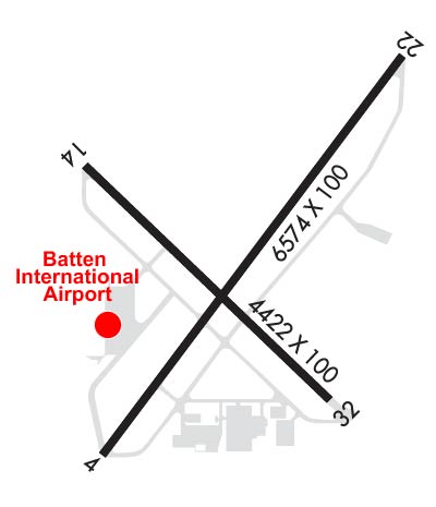
| Lat: N 4245.7 Long: W 08748.8 Elev: 674 Var: +02 Longest Runway: 6574 | ||
| Clr Del: 120.15 AWOS: 121.42 CTAF: 123.07 | ||
| ||||||||||||||||||||||||||||||
| ||||||||||||||||||||||||||||||
| ||||||||||||||||||||||||||||||
| Rwy | Rwy | |||||||
| 6574x100 | 5840' | 108.70 - 041° | 6574x100 | 6184' | ||||
| 4422x100 | 3616' | 4422x100 | 4422' | |||||
| Runway ID | Single Wheel | Double Wheel | Double Tandem Wheel | Dual Double Wheel |
| 04/22 | 50,000 | 65,000 | N/A | N/A |
| 14/32 | 25,000 | 35,000 | N/A | N/A |
| These numbers are Advisory and are not limits. The Airport Manager should have more accurate Weight Limits | ||||
 Airport Diagram might not be current. | |
| Facility Name: | BATTEN INTL |
| City Name: | RACINE |
| County: | RACINE |
| State abbrev: | WI |
| State Name: | WISCONSIN |
| Ownership: | PRIVATELY OWNED |
| Use: | OPEN TO THE PUBLIC |
| Owner's Name: | RACINE COMMERCIAL APRT CORP. |
| Address: | 3239 N. GREEN BAY RD |
| RACINE, WI 53404 | |
| Owner's Phone: | 262-631-5620 |
| Manager's Name: | TAMARA SANDBERG |
| Address: | 3239 N. GREEN BAY RD |
| RACINE, WI 53404 | |
| Phone: | 262-631-5620 |
| FAA Region: | GREAT LAKES |
| FAA Field Office: | CHI |
| Date | Sunrise | Sunset |
|---|---|---|
| 09/24/21 Friday | 6:40 | 18:45 |
| 09/25/21 Saturday | 6:42 | 18:44 |
| 09/26/21 Sunday | 6:43 | 18:42 |
| 09/27/21 Monday | 6:44 | 18:40 |
| 09/28/21 Tuesday | 6:45 | 18:38 |
| 09/29/21 Wednesday | 6:46 | 18:36 |
| 09/30/21 Thursday | 6:47 | 18:35 |
| 10/01/21 Friday | 6:48 | 18:33 |
| 10/02/21 Saturday | 6:49 | 18:31 |
| 10/03/21 Sunday | 6:50 | 18:29 |
| 10/04/21 Monday | 6:52 | 18:28 |
| 10/05/21 Tuesday | 6:53 | 18:26 |
| 10/06/21 Wednesday | 6:54 | 18:24 |
| 10/07/21 Thursday | 6:55 | 18:23 |
| Airport Attendance Schedule | SAT SUN 0800-1700, MON-FRI 0700-1700 |
| Airport Status | OPERATIONAL (This Status can change at any time - please check NOTAMS) |
| Airport Lighting Schedule | ACTVT HIRL RY 04/22 & MIRL RY 14/32; PAPI RY 14; REIL RYS 22, 14 & 32; MALSF RY 04 - CTAF. PAPI RYS 04 & 22 OPERS 24 HRS. |
| Airport Storage Available | Tie Downs, Hanger |
| Extra Services Available | Charter, Flight Instruction, Aircraft Rental |
| Wind Indicator | YES - (lighted) |
| Control Tower | NO |
| CTAF Frequency | 123.075 |
| Unicom Frequency | 123.075 |
| Rotating Beacon Color | CLEAR-GREEN (Light Land Airport) |
| Segmented Circle | NO |
| Landing Fee | YES; LNDG FEE FOR JET ACFT. |
| Airport Inspected | STATE - performed by STATE AERONAUTICAL PERSONNEL |
| Inspection Date | 06/15/2021 |
| Type of Fuel Available | Grade 100LL, JET A (freeze point -40C)MOGAS |
| Airframe Repair Service | MAJOR |
| Power Plant Repair Service | MAJOR |
| Latitude | N4245.7 |
| Longitude | W08748.8 (ESTIMATED) |
| Arpt Elevation | 673ft (SURVEYED) |
| Magnetic Variation | 02W |
| 2 miles NW | of RACINE |
| Traffic Pattern Altitude | |
| Sectional Chart | CHICAGO |
| Operations (Reported) | Yearly | Avg. Daily |
|---|---|---|
| General Aviation Transient | 20000 | 55 |
| General Aviation Local | 25000 | 68 |
| Air Taxi | 2000 | 5 |
| Commerical | 0 | 0 |
| Commuter | 0 | 0 |
| Military | 0 | 0 |
| Aircraft based on Field | |
|---|---|
| General Aviation Singles | 60 |
| General Aviation Multi | 7 |
| Jet Aircraft | 4 |
| General Aviation Helicopters | 4 |
| Military Aircraft | 0 |
| Gliders | 0 |
| Ultralights | 1 |
| FSS on field | NO |
| FSS tie-in | GREEN BAY |
| FSS Phone | 1-800-WX-BRIEF |
| Who issues Notams | RAC |
| Notam D service at airport | YES |
| ARTCC Name | CHICAGO |
| Airport Certification | |
| Aircraft Rescue & Firefighting Index | None |
| Airport of Entry | YES |
| Custom Landing Rights | YES |
| Joint Civil/Military | No |
| Military Landing rights | No |
| NATIONAL PLAN OF INTEGRATED AIRPORT SYSTEMS (NPIAS) |
| INSTALLATION OF NAVIGATIONAL FACILITIES ON PRIVATELY OWNED AIRPORTS UNDER F&E PROGRAM |
| ASSURANCES PURSUANT TO TITLE VI, CIVIL RIGHTS ACT OF 1964 |
| MIGRATORY WATERFOWL ON & INVOF ARPT. |
| FOR CD CTC CHICAGO ARTCC AT 630-906-8921. |
Airport Communications & Frequencies:
| ||||||||||||||||
| Runway: 04 | Runway: 22 | ||
| Mag heading: | 39° | Mag heading: | 219° |
| Rwy Slope: | -.11% Down | Rwy Slope: | .11% Up |
| Approach: | ILS | Approach: | |
| Pattern: | Left Traffic | Pattern: | Left Traffic |
| Markings: | PRECISION INSTRUMENT | Markings: | PRECISION INSTRUMENT |
| Marking Condition: | GOOD | Marking Condition: | GOOD |
| Arresting Dev: | Arresting Dev: | ||
| Lat & Long: | N4245.3 W08749.2 | Lat. & Long.: | N4246.1 W08748.3 |
| Elev: | 672.4 ft. MSL | Elev: | 665.2 ft. MSL |
| TCH: | 45 ft. AGL | TCH: | 46 ft. AGL |
| Visual Glide Path: | 3.00 degrees | Visual Glide Path: | 3.00 degrees |
| Displaced Threshold: | 734 feet | Displaced Threshold: | 390 feet |
| Touchdown Zone: | YES | Touchdown Zone: | YES |
| Touchdown Elev.: | 667.8 feet | Touchdown Elev.: | 666.3 feet |
| Visual Glide Slope: | 4-Light PAPI on LEFT side of Runway | Visual Glide Slope: | 4-Light PAPI on LEFT side of Runway |
| RVR Equipment: | RVR Equipment: | ||
| RVV Equipment: | NO | RVV Equipment: | NO |
| Approach Lights: | MALSF - 1,400 foot medium intensity approach lighting system with sequenced flashers | Approach Lights: | |
| REIL: | NO | REIL: | YES |
| Centerline Lights: | NO | Centerline Lights: | NO |
| Touchdown lights: | NO | Touchdown lights: | NO |
| Runway Category: | Precision Instrument Runway | Runway Category: | Runway with a Non-precision Approach having visibility minimums greater than 3/4 mile |
| Declared Distances: | Declared Distances: | ||
| Obstructions: | ROAD | Obstructions: | RR |
| Marked: | NOT Marked/Lighted | Marked: | NOT Marked/Lighted |
| Clearance slope: | APCH RATIO 38:1 TO DSPLCD THR; 29 FT TREE 1100 FT 350 FT R. | Clearance slope: | APCH RATIO 21:1 TO DSPLCD THR; 29 FT TREE 615 FT FM DSPCLD THR; 65 FT R. |
| Obstruction height: | 6 feet AGL | Obstruction height: | 8 feet AGL |
| Dist. from runway: | 200 feet | Dist. from runway: | 200 feet |
| Centerline offset: | 140 right of centerline | Centerline offset: | 50 feet left of centerline |
| Comments: | 10 FT FENCE 40 TO 80 FT FM RWY END BOTH SIDES OF CNTRLN; 15 FT RD 0 TO 200 FT FM RWY END BOTH SIDES OF CNTRLN. | Comments: | 60 FT RR 0 TO 200 FT FM RWY END; 60 TO 230 FT L; 20 FT TREE 10 FT FM RWY END; 130 FT L. |
| Runway: 14 | Runway: 32 | ||
| Mag heading: | 135° | Mag heading: | 315° |
| Rwy Slope: | -.35% Down | Rwy Slope: | .35% Up |
| Approach: | Approach: | ||
| Pattern: | Left Traffic | Pattern: | Left Traffic |
| Markings: | NONPRECISION INSTRUMENT | Markings: | NONPRECISION INSTRUMENT |
| Marking Condition: | GOOD | Marking Condition: | GOOD |
| Arresting Dev: | Arresting Dev: | ||
| Lat & Long: | N4245.9 W08749.3 | Lat. & Long.: | N4245.4 W08748.6 |
| Elev: | 673.6 ft. MSL | Elev: | 658.1 ft. MSL |
| TCH: | 59 ft. AGL | TCH: | |
| Visual Glide Path: | 4.00 degrees | Visual Glide Path: | |
| Displaced Threshold: | 806 feet | Displaced Threshold: | No |
| Touchdown Zone: | YES | Touchdown Zone: | YES |
| Touchdown Elev.: | 669.7 feet | Touchdown Elev.: | 666.6 feet |
| Visual Glide Slope: | 4-Light PAPI on LEFT side of Runway | Visual Glide Slope: | |
| RVR Equipment: | RVR Equipment: | ||
| RVV Equipment: | NO | RVV Equipment: | NO |
| Approach Lights: | Approach Lights: | ||
| REIL: | YES | REIL: | YES |
| Centerline Lights: | NO | Centerline Lights: | NO |
| Touchdown lights: | NO | Touchdown lights: | NO |
| Runway Category: | Runway with a Visual Approach | Runway Category: | Runway with a Non-precision Approach having visibility minimums greater than 3/4 mile |
| Declared Distances: | Declared Distances: | ||
| Obstructions: | ROAD | Obstructions: | TREE |
| Marked: | NOT Marked/Lighted | Marked: | NOT Marked/Lighted |
| Clearance slope: | APCH RATIO 16:1 TO DSPLCD THLD; 58 FT TREE 900 FT FM DSPLCD THR; 150 FT R. | Clearance slope: | 18:1 |
| Obstruction height: | 15 feet AGL | Obstruction height: | 31 feet AGL |
| Dist. from runway: | 200 feet | Dist. from runway: | 770 feet |
| Centerline offset: | Centerline offset: | 100 feet left of centerline | |
| Comments: | 10 FT FENCE 0 TO 200 FT FM RWY END BOTH SIDES OF CNTRLN; 15 FT RD 0 TO 200 FT FM RWY END BOTH SIDES OF CNTRLN; 58 FT TREE 80 FT FM RWY END; 175 FT R. | Comments: |
Thanks for using FltPlan.com
all rights reserved © 1999-2021 by Flight Plan LLC