
| PLYMOUTH MUNI PLYMOUTH MA |
| |
| Lat: N 4154.5 Long: W 07043.7 Elev: 148 Var: +16 Longest Runway: 4650 | ||
| Clr Del: 127.75 AWOS: 135.62 CTAF: 122.72 | ||
| ||||||||||||||||||||||||||||||||||||||||||||
| ||||||||||||||||||||||||||||||||||||||||||||
| ||||||||||||||||||||||||||||||||||||||||||||
| ||||||||||||||||||||||||||||||||||||||||||||
| ||||||||||||||||||||||||||||||||||||||||||||
| Rwy | Rwy | |||||||
| 4650x75 | 4650' | 109.35 - 056° | 4650x75 | 4350' | ||||
| 4350x75 | 4350' | 4350x75 | 4350' | |||||
| Runway ID | Single Wheel | Double Wheel | Double Tandem Wheel | Dual Double Wheel |
| 06/24 | 25,000 | 64,000 | N/A | N/A |
| 15/33 | 25,000 | 64,000 | N/A | N/A |
| These numbers are Advisory and are not limits. The Airport Manager should have more accurate Weight Limits | ||||
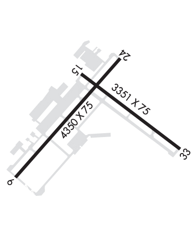 Airport Diagram might not be current. | |
| Facility Name: | PLYMOUTH MUNI |
| City Name: | PLYMOUTH |
| County: | PLYMOUTH |
| State abbrev: | MA |
| State Name: | MASSACHUSETTS |
| Ownership: | PUBLICLY OWNED |
| Use: | OPEN TO THE PUBLIC |
| Owner's Name: | TOWN OF PLYMOUTH |
| Address: | 246 SOUTH MEADOW RD |
| PLYMOUTH, MA 02360 | |
| Owner's Phone: | 508-746-2020 |
| Manager's Name: | MATTHEW CARDILLO |
| Address: | 246 SOUTH MEADOW RD |
| PLYMOUTH, MA 02360 | |
| Phone: | 508-746-2020 |
| FAA Region: | NEW ENGLAND |
| FAA Field Office: | NONE |
| Date | Sunrise | Sunset |
|---|---|---|
| 06/19/25 Thursday | 5:07 | 20:21 |
| 06/20/25 Friday | 5:07 | 20:21 |
| 06/21/25 Saturday | 5:08 | 20:22 |
| 06/22/25 Sunday | 5:08 | 20:22 |
| 06/23/25 Monday | 5:08 | 20:22 |
| 06/24/25 Tuesday | 5:08 | 20:22 |
| 06/25/25 Wednesday | 5:09 | 20:22 |
| 06/26/25 Thursday | 5:09 | 20:22 |
| 06/27/25 Friday | 5:09 | 20:22 |
| 06/28/25 Saturday | 5:10 | 20:22 |
| 06/29/25 Sunday | 5:10 | 20:22 |
| 06/30/25 Monday | 5:11 | 20:22 |
| 07/01/25 Tuesday | 5:11 | 20:22 |
| 07/02/25 Wednesday | 5:12 | 20:22 |
| Airport Attendance Schedule | 7 Days A Week 0600-2200 |
| Airport Status | OPERATIONAL (This Status can change at any time - please check NOTAMS) |
| Airport Lighting Schedule | ACTVT MALSF RWY 06; REIL RWY 24; PAPI RWY 06, 24 & 33; MIRL RWY 06/24 & 15/33 - 122.9. |
| Airport Storage Available | Tie Downs, Hanger |
| Extra Services Available | Air Freight, Crop Dusting, Air Ambulance, Avionics, Charter, Flight Instruction, Aircraft Rental, Aircraft Sales |
| Wind Indicator | YES - (unlit) |
| Control Tower | NO |
| CTAF Frequency | 122.725 |
| Unicom Frequency | 122.725 |
| Rotating Beacon Color | WG |
| Segmented Circle | YES |
| Landing Fee | NO |
| Airport Inspected | STATE - performed by STATE AERONAUTICAL PERSONNEL |
| Inspection Date | 07/15/2021 |
| Type of Fuel Available | Grade 100LL, JET A (freeze point -40C) |
| Airframe Repair Service | MAJOR |
| Power Plant Repair Service | MAJOR |
| Latitude | N4154.5 |
| Longitude | W07043.7 (ESTIMATED) |
| Arpt Elevation | 148ft (SURVEYED) |
| Magnetic Variation | 16W |
| 4 miles SW | of PLYMOUTH |
| Traffic Pattern Altitude | |
| Sectional Chart | NEW YORK |
| Operations (Reported) | Yearly | Avg. Daily |
|---|---|---|
| General Aviation Transient | 0 | 0 |
| General Aviation Local | 0 | 0 |
| Air Taxi | 0 | 0 |
| Commerical | 0 | 0 |
| Commuter | 0 | 0 |
| Military | 0 | 0 |
| Aircraft based on Field | |
|---|---|
| General Aviation Singles | 0 |
| General Aviation Multi | 0 |
| Jet Aircraft | 0 |
| General Aviation Helicopters | 0 |
| Military Aircraft | 0 |
| Gliders | 0 |
| Ultralights | 0 |
| FSS on field | NO |
| FSS tie-in | BRIDGEPORT |
| FSS Phone | 1-800-WX-BRIEF |
| Who issues Notams | PYM |
| Notam D service at airport | YES |
| ARTCC Name | BOSTON |
| Airport Certification | |
| Aircraft Rescue & Firefighting Index | None |
| Airport of Entry | No |
| Custom Landing Rights | No |
| Joint Civil/Military | No |
| Military Landing rights | YES |
| NATIONAL PLAN OF INTEGRATED AIRPORT SYSTEMS (NPIAS) |
| GRANT AGREEMENTS UNDER FAAP/ADAP/AIP |
| SURPLUS PROPERTY AGREEMENT UNDER PUBLIC LAW 289 |
| ASSURANCES PURSUANT TO TITLE VI, CIVIL RIGHTS ACT OF 1964 |
| NO TGLS 2100-0800 LCL. |
| BE AWARE OF HIGH SPD MIL JET AND HVY HEL TFC INVOF CAPE COD CGAS. |
| WILDLIFE ON AND INVOF AIRPORT. |
| DEPG ACFT ENCOURAGED TO FLY LCL NOISE ABATEMENT PROCS. |
| FOR CD CTC BOSTON APCH AT 603-594-5554. |
| (CONTACT TITLE) TMAHER@TOWNHALL.PLYMOUTH.MA.US. |
Airport Communications & Frequencies:
| ||||||||||||||||
| Runway: 06 | Runway: 24 | ||
| Mag heading: | 56° | Mag heading: | 236° |
| Rwy Slope: | .19% Up | Rwy Slope: | -.19% Down |
| Approach: | ILS/DME | Approach: | |
| Pattern: | Left Traffic | Pattern: | Left Traffic |
| Markings: | PRECISION INSTRUMENT | Markings: | NONPRECISION INSTRUMENT |
| Marking Condition: | GOOD | Marking Condition: | GOOD |
| Arresting Dev: | Arresting Dev: | ||
| Lat & Long: | N4154.3 W07044.2 | Lat. & Long.: | N4154.8 W07043.5 |
| Elev: | 135.1 ft. MSL | Elev: | 144.0 ft. MSL |
| TCH: | 40 ft. AGL | TCH: | 40 ft. AGL |
| Visual Glide Path: | 3.00 degrees | Visual Glide Path: | 4.00 degrees |
| Displaced Threshold: | No | Displaced Threshold: | 300 feet |
| Touchdown Zone: | YES | Touchdown Zone: | YES |
| Touchdown Elev.: | 144.9 feet | Touchdown Elev.: | 148.1 feet |
| Visual Glide Slope: | 4-Light PAPI on LEFT side of Runway | Visual Glide Slope: | 4-Light PAPI on LEFT side of Runway |
| RVR Equipment: | RVR Equipment: | ||
| RVV Equipment: | NO | RVV Equipment: | NO |
| Approach Lights: | MALSF - 1,400 foot medium intensity approach lighting system with sequenced flashers | Approach Lights: | |
| REIL: | NO | REIL: | YES |
| Centerline Lights: | NO | Centerline Lights: | NO |
| Touchdown lights: | NO | Touchdown lights: | NO |
| Runway Category: | Precision Instrument Runway | Runway Category: | Runway with a Non-precision Approach having visibility minimums greater than 3/4 mile |
| Declared Distances: | Declared Distances: | ||
| Obstructions: | TREES | Obstructions: | TREES |
| Marked: | NOT Marked/Lighted | Marked: | NOT Marked/Lighted |
| Clearance slope: | 50:1 | Clearance slope: | 20:1 |
| Obstruction height: | 35 feet AGL | Obstruction height: | 65 feet AGL |
| Dist. from runway: | 1700 feet | Dist. from runway: | 1500 feet |
| Centerline offset: | Centerline offset: | ||
| Comments: | Comments: |
| Runway: 15 | Runway: 33 | ||
| Mag heading: | 146° | Mag heading: | 326° |
| Rwy Slope: | -.27% Down | Rwy Slope: | .27% Up |
| Approach: | Approach: | ||
| Pattern: | Left Traffic | Pattern: | Left Traffic |
| Markings: | NONPRECISION INSTRUMENT | Markings: | NONPRECISION INSTRUMENT |
| Marking Condition: | GOOD | Marking Condition: | GOOD |
| Arresting Dev: | Arresting Dev: | ||
| Lat & Long: | N4154.7 W07043.8 | Lat. & Long.: | N4154.3 W07043.1 |
| Elev: | 145.0 ft. MSL | Elev: | 133.1 ft. MSL |
| TCH: | TCH: | 40 ft. AGL | |
| Visual Glide Path: | Visual Glide Path: | 3.00 degrees | |
| Displaced Threshold: | No | Displaced Threshold: | No |
| Touchdown Zone: | YES | Touchdown Zone: | YES |
| Touchdown Elev.: | 146.9 feet | Touchdown Elev.: | 142.3 feet |
| Visual Glide Slope: | Visual Glide Slope: | 4-Light PAPI on LEFT side of Runway | |
| RVR Equipment: | RVR Equipment: | ||
| RVV Equipment: | NO | RVV Equipment: | NO |
| Approach Lights: | Approach Lights: | ||
| REIL: | NO | REIL: | NO |
| Centerline Lights: | NO | Centerline Lights: | NO |
| Touchdown lights: | NO | Touchdown lights: | NO |
| Runway Category: | Runway with a Non-precision Approach having visibility minimums greater than 3/4 mile | Runway Category: | D |
| Declared Distances: | TORA:4350' TODA:4350' ASDA:4350' LDA:4350' | Declared Distances: | TORA:4350' TODA:4350' ASDA:4650' LDA:4350' |
| Obstructions: | TREES | Obstructions: | TREE |
| Marked: | NOT Marked/Lighted | Marked: | NOT Marked/Lighted |
| Clearance slope: | 20:1 | Clearance slope: | 20:1 |
| Obstruction height: | 27 feet AGL | Obstruction height: | 80 feet AGL |
| Dist. from runway: | 750 feet | Dist. from runway: | 1800 feet |
| Centerline offset: | 125 left of centerline | Centerline offset: | 125 feet left of centerline |
| Comments: | Comments: |
Thanks for using FltPlan.com
all rights reserved © 1999-2025 by Flight Plan LLC