
| HAMPTON ROADS EXECUTIVE NORFOLK VA |
| |
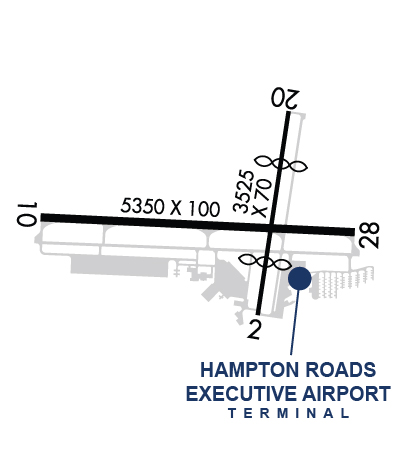
| Lat: N 3646.8 Long: W 07627.1 Elev: 28 Var: +10 Longest Runway: 5350 | ||
| Clr Del: 757-464-0757 AWOS: 118.37 CTAF: 122.72 | ||
| ||||||
| ||||||
|
| Rwy | Rwy | |||||||
| 3525x70 | 2627' | 3525x70 | 2597' | |||||
| 5350x100 | 5350' | 110.75 - 102° | 5350x100 | 5350' | ||||
| Runway ID | Single Wheel | Double Wheel | Double Tandem Wheel | Dual Double Wheel |
| 02/20 | 12,500 | N/A | N/A | N/A |
| 10/28 | N/A | 75,000 | N/A | N/A |
| These numbers are Advisory and are not limits. The Airport Manager should have more accurate Weight Limits | ||||
 Airport Diagram might not be current. | |
| Facility Name: | HAMPTON ROADS EXEC |
| City Name: | NORFOLK |
| County: | CHESAPEAKE |
| State abbrev: | VA |
| State Name: | VIRGINIA |
| Ownership: | PRIVATELY OWNED |
| Use: | OPEN TO THE PUBLIC |
| Owner's Name: | VIRGINIA AVIATION ASSOCIATES, L.L.C |
| Address: | 5172 W. MILITARY HWY, SUITE A |
| CHESAPEAKE, VA 23321 | |
| Owner's Phone: | 757-465-0260 |
| Manager's Name: | STEVE FOX; STEVEN I. FOX AUTH PSNAL TO MAKE CHGS 757-465-0260. |
| Address: | 5172 W. MILITARY HWY |
| CHESAPEAKE, VA 23321 | |
| Phone: | 757-465-0260 |
| FAA Region: | EASTERN |
| FAA Field Office: | DCA |
| Date | Sunrise | Sunset |
|---|---|---|
| 05/03/26 Sunday | 6:10 | 19:56 |
| 05/04/26 Monday | 6:09 | 19:57 |
| 05/05/26 Tuesday | 6:08 | 19:58 |
| 05/06/26 Wednesday | 6:07 | 19:59 |
| 05/07/26 Thursday | 6:06 | 19:59 |
| 05/08/26 Friday | 6:05 | 20:00 |
| 05/09/26 Saturday | 6:04 | 20:01 |
| 05/10/26 Sunday | 6:03 | 20:02 |
| 05/11/26 Monday | 6:02 | 20:03 |
| 05/12/26 Tuesday | 6:01 | 20:04 |
| 05/13/26 Wednesday | 6:00 | 20:05 |
| 05/14/26 Thursday | 5:59 | 20:05 |
| 05/15/26 Friday | 5:58 | 20:06 |
| 05/16/26 Saturday | 5:58 | 20:07 |
| Airport Attendance Schedule | 7 Days A Week 0700 - 1900 |
| Airport Status | OPERATIONAL (This Status can change at any time - please check NOTAMS) |
| Airport Lighting Schedule | ACTVT REIL RWY 10 & 28; PAPI RWY 10 & 28; MIRL RWY 02/20; HIRL RWY 10/28 - CTAF. |
| Airport Storage Available | Tie Downs, Hanger |
| Extra Services Available | Avionics, Flight Instruction, Aircraft Rental, Aircraft Sales, Annual Surveying |
| Wind Indicator | YES - (lighted) |
| Control Tower | NO |
| CTAF Frequency | 122.725 |
| Unicom Frequency | 122.725 |
| Rotating Beacon Color | WG |
| Segmented Circle | NO |
| Landing Fee | NO |
| Airport Inspected | STATE - performed by STATE AERONAUTICAL PERSONNEL |
| Inspection Date | 08/26/2025 |
| Type of Fuel Available | Grade 100LL, JET A |
| Airframe Repair Service | MAJOR |
| Power Plant Repair Service | MAJOR |
| Latitude | N3646.8 |
| Longitude | W07627.1 (ESTIMATED) |
| Arpt Elevation | 28ft (SURVEYED) |
| Magnetic Variation | 10W |
| 7 miles SW | of NORFOLK |
| Traffic Pattern Altitude | TPA 677 FT AGL FOR HELICOPTERS. |
| Sectional Chart | WASHINGTON |
| Operations (Reported) | Yearly | Avg. Daily |
|---|---|---|
| General Aviation Transient | 0 | 0 |
| General Aviation Local | 0 | 0 |
| Air Taxi | 0 | 0 |
| Commerical | 0 | 0 |
| Commuter | 0 | 0 |
| Military | 0 | 0 |
| Aircraft based on Field | |
|---|---|
| General Aviation Singles | 0 |
| General Aviation Multi | 0 |
| Jet Aircraft | 0 |
| General Aviation Helicopters | 0 |
| Military Aircraft | 0 |
| Gliders | 0 |
| Ultralights | 0 |
| FSS on field | NO |
| FSS tie-in | LEESBURG |
| FSS Phone | 1-800-WX-BRIEF |
| Who issues Notams | DCA |
| Notam D service at airport | YES |
| ARTCC Name | WASHINGTON |
| Airport Certification | |
| Aircraft Rescue & Firefighting Index | None |
| Airport of Entry | No |
| Custom Landing Rights | No |
| Joint Civil/Military | No |
| Military Landing rights | No |
| NATIONAL PLAN OF INTEGRATED AIRPORT SYSTEMS (NPIAS) |
| GRANT AGREEMENTS UNDER FAAP/ADAP/AIP |
| ASSURANCES PURSUANT TO TITLE VI, CIVIL RIGHTS ACT OF 1964 |
| DEER ON & INVOF ARPT. |
| EXTENSIVE HELICOPTER TRAINING. |
| RWY 10/28 PREFERRED USE RWY. BE ALERT FOR MULTIPLE 1000 FT AGL TWRS 1.5 NM NW OF FLD. |
| FOR CD CTC NORFOLK APCH AT 757-464-0757. |
| RWY 02/2 0 RWY HAS NMRS CRACKS. TWYS SUPPORTING RWY HAVE NMRS CRACKS AND FOD POTENTIAL. |
Airport Communications & Frequencies:
| ||||||||||||||||||
| Runway: 02 | Runway: 20 | ||
| Mag heading: | 19° | Mag heading: | 199° |
| Rwy Slope: | -.05% Down | Rwy Slope: | .05% Up |
| Approach: | Approach: | ||
| Pattern: | Left Traffic | Pattern: | Right Traffic; FIXED WING ACFT. |
| Markings: | NONPRECISION INSTRUMENT | Markings: | NONPRECISION INSTRUMENT |
| Marking Condition: | FAIR | Marking Condition: | FAIR |
| Arresting Dev: | Arresting Dev: | ||
| Lat & Long: | N3646.6 W07627.0 | Lat. & Long.: | N3647.2 W07626.9 |
| Elev: | 21.2 ft. MSL | Elev: | 19.6 ft. MSL |
| TCH: | TCH: | ||
| Visual Glide Path: | Visual Glide Path: | ||
| Displaced Threshold: | 898 feet; CLR SLP 16:1 TREE LCTD 1546 FT FM THR 208 FT RIGHT ON APCH. | Displaced Threshold: | 928 feet; CLR SLP 17:1 TREE LCTD 1537 FT FM THR 212 FT R ON APCH. |
| Touchdown Zone: | YES | Touchdown Zone: | YES |
| Touchdown Elev.: | 21.9 feet | Touchdown Elev.: | 21.9 feet |
| Visual Glide Slope: | Visual Glide Slope: | ||
| RVR Equipment: | RVR Equipment: | ||
| RVV Equipment: | NO | RVV Equipment: | NO |
| Approach Lights: | Approach Lights: | ||
| REIL: | NO | REIL: | NO |
| Centerline Lights: | NO | Centerline Lights: | NO |
| Touchdown lights: | NO | Touchdown lights: | NO |
| Runway Category: | Runway with a Visual Approach | Runway Category: | Runway with a Visual Approach |
| Declared Distances: | Declared Distances: | ||
| Obstructions: | ROAD | Obstructions: | TREES |
| Marked: | NOT Marked/Lighted | Marked: | NOT Marked/Lighted |
| Clearance slope: | 4:1; APCH RATIO 94:1 TO DSPLCD THR (ROAD); APCH RATIO 22:1 TO DSPLCD THR FM 70 FT TREE 883 FT FM RWY END, 189 FT LEFT. | Clearance slope: | 6:1; APCH RATIO 22:1 TO DSPLCD THR CTLG OBST; APCH RATIO 21:1 TO DSPLCD THR FM 104 FT TREE 1505 FT FM RWY END, 108 FT RIGHT. |
| Obstruction height: | 10 feet AGL | Obstruction height: | 63 feet AGL |
| Dist. from runway: | 244 feet | Dist. from runway: | 629 feet |
| Centerline offset: | 125 right of centerline | Centerline offset: | 144 feet right of centerline |
| Comments: | Comments: |
| Runway: 10 | Runway: 28 | ||
| Mag heading: | 102° | Mag heading: | 282° |
| Rwy Slope: | -.09% Down | Rwy Slope: | .09% Up |
| Approach: | ILS/DME | Approach: | |
| Pattern: | Right Traffic; FIXED WING ACFT. | Pattern: | Left Traffic |
| Markings: | PRECISION INSTRUMENT | Markings: | NONPRECISION INSTRUMENT |
| Marking Condition: | GOOD | Marking Condition: | GOOD |
| Arresting Dev: | Arresting Dev: | ||
| Lat & Long: | N3646.9 W07627.7 | Lat. & Long.: | N3646.8 W07626.6 |
| Elev: | 27.9 ft. MSL | Elev: | 23.1 ft. MSL |
| TCH: | 45 ft. AGL | TCH: | 45 ft. AGL |
| Visual Glide Path: | 3.00 degrees | Visual Glide Path: | 3.00 degrees |
| Displaced Threshold: | No | Displaced Threshold: | No |
| Touchdown Zone: | YES | Touchdown Zone: | YES |
| Touchdown Elev.: | 27.9 feet | Touchdown Elev.: | 25.0 feet |
| Visual Glide Slope: | 4-Light PAPI on LEFT side of Runway | Visual Glide Slope: | 4-Light PAPI on LEFT side of Runway |
| RVR Equipment: | RVR Equipment: | ||
| RVV Equipment: | NO | RVV Equipment: | NO |
| Approach Lights: | Approach Lights: | ||
| REIL: | YES | REIL: | YES |
| Centerline Lights: | NO | Centerline Lights: | NO |
| Touchdown lights: | NO | Touchdown lights: | NO |
| Runway Category: | Runway with a Non-precision Approach having visibility minimums greater than 3/4 mile | Runway Category: | Runway with a Visual Approach |
| Declared Distances: | Declared Distances: | ||
| Obstructions: | TREE | Obstructions: | TREE |
| Marked: | NOT Marked/Lighted | Marked: | NOT Marked/Lighted |
| Clearance slope: | 27:1 | Clearance slope: | 18:1 |
| Obstruction height: | 44 feet AGL | Obstruction height: | 50 feet AGL |
| Dist. from runway: | 1429 feet | Dist. from runway: | 1109 feet |
| Centerline offset: | 201 right of centerline | Centerline offset: | 278 feet right of centerline |
| Comments: | Comments: | BRUSH LCTD APRXLY 240 FT FM CNTRLN. |
Thanks for using FltPlan.com
all rights reserved © 1999-2026 by Flight Plan LLC
