
| HERITAGE FIELD AIRPORT POTTSTOWN PA |
| |
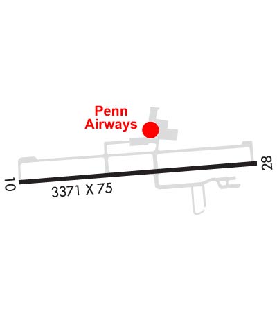
| Lat: N 4014.4 Long: W 07533.4 Elev: 308 Var: +12 Longest Runway: 3371 | ||
| Clr Del: 118.55 AWOS: 119.42 CTAF: 122.7 | ||

| ||||||||||||||||||||||||||||||||||||||||||||||||||||||||||||||||||||
| ||||||||||||||||||||||||||||||||||||||||||||||||||||||||||||||||||||
| ||||||||||||||||||||||||||||||||||||||||||||||||||||||||||||||||||||
| Rwy | Rwy | |||||||
| 3371x75 | 3371' | 3371x75 | 3181' | 108.30 - 276° | ||||
| Runway ID | Single Wheel | Double Wheel | Double Tandem Wheel | Dual Double Wheel |
| 10/28 | N/A | N/A | N/A | N/A |
| These numbers are Advisory and are not limits. The Airport Manager should have more accurate Weight Limits | ||||
 Airport Diagram might not be current. | |
| Facility Name: | HERITAGE FLD |
| City Name: | POTTSTOWN |
| County: | MONTGOMERY |
| State abbrev: | PA |
| State Name: | PENNSYLVANIA |
| Ownership: | PRIVATELY OWNED |
| Use: | OPEN TO THE PUBLIC |
| Owner's Name: | LIMERICK AVIATION LP |
| Address: | 3310 WEST RIDGE PIKE |
| POTTSTOWN, PA 19464 | |
| Owner's Phone: | 610-495-7000 |
| Manager's Name: | JEFF HEACOCK |
| Address: | 3310 WEST RIDGE PIKE |
| POTTSTOWN, PA 19464 | |
| Phone: | (610) 495-7000 |
| FAA Region: | EASTERN |
| FAA Field Office: | HAR |
| Date | Sunrise | Sunset |
|---|---|---|
| 06/19/25 Thursday | 5:32 | 20:35 |
| 06/20/25 Friday | 5:32 | 20:35 |
| 06/21/25 Saturday | 5:33 | 20:35 |
| 06/22/25 Sunday | 5:33 | 20:35 |
| 06/23/25 Monday | 5:33 | 20:36 |
| 06/24/25 Tuesday | 5:33 | 20:36 |
| 06/25/25 Wednesday | 5:34 | 20:36 |
| 06/26/25 Thursday | 5:34 | 20:36 |
| 06/27/25 Friday | 5:34 | 20:36 |
| 06/28/25 Saturday | 5:35 | 20:36 |
| 06/29/25 Sunday | 5:35 | 20:36 |
| 06/30/25 Monday | 5:36 | 20:36 |
| 07/01/25 Tuesday | 5:36 | 20:36 |
| 07/02/25 Wednesday | 5:37 | 20:36 |
| Airport Attendance Schedule | MON-FRI 0700-2000, SAT-SUN 0700-1800 |
| Airport Status | OPERATIONAL (This Status can change at any time - please check NOTAMS) |
| Airport Lighting Schedule | ACTVT MIRL RWY 10/28 - 122.7.; ACTVT ROTG BCN - 122.7. |
| Airport Storage Available | Tie Downs, Hanger |
| Extra Services Available | Air Freight, Charter, Flight Instruction |
| Wind Indicator | YES - (lighted) |
| Control Tower | NO |
| CTAF Frequency | 122.700 |
| Unicom Frequency | 122.700 |
| Rotating Beacon Color | WG |
| Segmented Circle | YES |
| Landing Fee | YES |
| Airport Inspected | STATE - performed by STATE AERONAUTICAL PERSONNEL |
| Inspection Date | 05/08/2024 |
| Type of Fuel Available | Grade 100LL, JET A (freeze point -40C) |
| Airframe Repair Service | MAJOR |
| Power Plant Repair Service | MAJOR |
| Latitude | N4014.4 |
| Longitude | W07533.4 (ESTIMATED) |
| Arpt Elevation | 308ft (SURVEYED) |
| Magnetic Variation | 12W |
| 3 miles E | of POTTSTOWN |
| Traffic Pattern Altitude | |
| Sectional Chart | NEW YORK |
| Operations (Reported) | Yearly | Avg. Daily |
|---|---|---|
| General Aviation Transient | 0 | 0 |
| General Aviation Local | 0 | 0 |
| Air Taxi | 0 | 0 |
| Commerical | 0 | 0 |
| Commuter | 0 | 0 |
| Military | 0 | 0 |
| Aircraft based on Field | |
|---|---|
| General Aviation Singles | 0 |
| General Aviation Multi | 0 |
| Jet Aircraft | 0 |
| General Aviation Helicopters | 0 |
| Military Aircraft | 0 |
| Gliders | 0 |
| Ultralights | 0 |
| FSS on field | NO |
| FSS tie-in | WILLIAMSPORT |
| FSS Phone | 1-800-WX-BRIEF |
| Who issues Notams | PTW |
| Notam D service at airport | YES |
| ARTCC Name | NEW YORK |
| Airport Certification | |
| Aircraft Rescue & Firefighting Index | None |
| Airport of Entry | No |
| Custom Landing Rights | No |
| Joint Civil/Military | No |
| Military Landing rights | No |
| NATIONAL PLAN OF INTEGRATED AIRPORT SYSTEMS (NPIAS) |
| ASSURANCES PURSUANT TO TITLE VI, CIVIL RIGHTS ACT OF 1964 |
| LGTD & MKD 507 FT AGL (769 FT MSL) STACK 6000 FT W OF RWY 10. |
| BIRDS & DEER ON & INVOF ARPT. |
| FOR CD CTC PHILADELPHIA APCH AT 800-354-9884. |
Airport Communications & Frequencies:
| |||||||||||||||||||
| Runway: 10 | Runway: 28 | ||
| Mag heading: | 96° | Mag heading: | 276° |
| Rwy Slope: | -.13% Down | Rwy Slope: | .13% Up |
| Approach: | Approach: | LOCALIZER | |
| Pattern: | Left Traffic | Pattern: | Right Traffic |
| Markings: | NONPRECISION INSTRUMENT | Markings: | NONPRECISION INSTRUMENT |
| Marking Condition: | GOOD | Marking Condition: | GOOD |
| Arresting Dev: | Arresting Dev: | ||
| Lat & Long: | N4014.3 W07533.8 | Lat. & Long.: | N4014.4 W07533.0 |
| Elev: | 307.0 ft. MSL | Elev: | 302.6 ft. MSL |
| TCH: | 45 ft. AGL | TCH: | 45 ft. AGL |
| Visual Glide Path: | 3.00 degrees | Visual Glide Path: | 3.00 degrees |
| Displaced Threshold: | No | Displaced Threshold: | 190 feet |
| Touchdown Zone: | YES | Touchdown Zone: | YES |
| Touchdown Elev.: | 308.2 feet | Touchdown Elev.: | 308.2 feet |
| Visual Glide Slope: | 2-Light PAPI on LEFT side of Runway | Visual Glide Slope: | 2-Light PAPI on LEFT side of Runway |
| RVR Equipment: | RVR Equipment: | ||
| RVV Equipment: | NO | RVV Equipment: | NO |
| Approach Lights: | Approach Lights: | ||
| REIL: | YES | REIL: | YES |
| Centerline Lights: | NO | Centerline Lights: | NO |
| Touchdown lights: | NO | Touchdown lights: | NO |
| Runway Category: | Runway with a Non-precision Approach | Runway Category: | Runway with a Non-precision Approach |
| Declared Distances: | Declared Distances: | ||
| Obstructions: | TREES | Obstructions: | TREES |
| Marked: | NOT Marked/Lighted | Marked: | NOT Marked/Lighted |
| Clearance slope: | 16:1 | Clearance slope: | 10:1; APCH RATIO 21:1 TO DTHR. |
| Obstruction height: | 61 feet AGL | Obstruction height: | 37 feet AGL |
| Dist. from runway: | 1223 feet | Dist. from runway: | 576 feet |
| Centerline offset: | 351 left of centerline | Centerline offset: | 269 feet right of centerline |
| Comments: | Comments: | 10 FT ROAD 0-200 FT FM THR. |
Thanks for using FltPlan.com
all rights reserved © 1999-2025 by Flight Plan LLC


