
| ERNEST A. LOVE FIELD PRESCOTT AZ |
| |
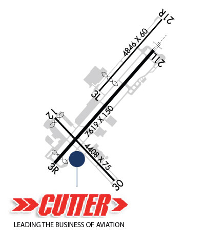
| Lat: N 3439.3 Long: W 11225.2 Elev: 5045 Var: -13 Longest Runway: 7619 | ||
| Clr Del: 119.25 Dept. ATIS: 127.2 Arr. ATIS: 127.2 AWOS: 127.2 Ground: 121.7 Tower: 125.3 | ||
| ||||||||||||||||||||||||||||||||||||||||||||||||||||||||||||||||||||
| ||||||||||||||||||||||||||||||||||||||||||||||||||||||||||||||||||||
| ||||||||||||||||||||||||||||||||||||||||||||||||||||||||||||||||||||
| Rwy | Rwy | |||||||
| 4395x60 | 4035' | 4395x60 | 4395' | |||||
| 7619x150 | 7239' | 7619x150 | 7619' | 108.50 - 208° | ||||
| 4408x75 | 4258' | 4408x75 | 4408' | |||||
| Runway ID | Single Wheel | Double Wheel | Double Tandem Wheel | Dual Double Wheel |
| 03L/21R | 12,500 | N/A | N/A | N/A |
| 03R/21L | 63,000 | 80,000 | 100,000 | N/A |
| 12/30 | 12,500 | N/A | N/A | N/A |
| These numbers are Advisory and are not limits. The Airport Manager should have more accurate Weight Limits | ||||
 Airport Diagram might not be current. | |
| Facility Name: | PRESCOTT RGNL/ERNEST A LOVE FLD |
| City Name: | PRESCOTT |
| County: | YAVAPAI |
| State abbrev: | AZ |
| State Name: | ARIZONA |
| Ownership: | PUBLICLY OWNED |
| Use: | OPEN TO THE PUBLIC |
| Owner's Name: | CITY OF PRESCOTT |
| Address: | 201 SOUTH CORTEZ STREET |
| PRESCOTT, AZ 86301 | |
| Owner's Phone: | 928-777-1114 |
| Manager's Name: | RICK CRIDER |
| Address: | 6630 AIRPORT AVENUE |
| PRESCOTT, AZ 86301 | |
| Phone: | 928-777-1114; H24 OPS - 928-777-1150. |
| FAA Region: | WESTERN-PACIFIC |
| FAA Field Office: | PHX |

| Date | Sunrise | Sunset |
|---|---|---|
| 04/25/26 Saturday | 5:46 | 19:10 |
| 04/26/26 Sunday | 5:45 | 19:10 |
| 04/27/26 Monday | 5:44 | 19:11 |
| 04/28/26 Tuesday | 5:43 | 19:12 |
| 04/29/26 Wednesday | 5:42 | 19:13 |
| 04/30/26 Thursday | 5:41 | 19:14 |
| 05/01/26 Friday | 5:40 | 19:14 |
| 05/02/26 Saturday | 5:39 | 19:15 |
| 05/03/26 Sunday | 5:38 | 19:16 |
| 05/04/26 Monday | 5:37 | 19:17 |
| 05/05/26 Tuesday | 5:36 | 19:18 |
| 05/06/26 Wednesday | 5:35 | 19:18 |
| 05/07/26 Thursday | 5:34 | 19:19 |
| 05/08/26 Friday | 5:33 | 19:20 |
| Airport Attendance Schedule | 7 Days A Week 0600-2200 |
| Airport Status | OPERATIONAL (This Status can change at any time - please check NOTAMS) |
| Airport Lighting Schedule | WHEN ATCT CLSD: ACTVT MALSR RWY 21L; REIL RWY 03L, 03R, 21R; PAPI RWY 03R & 21L; MIRL 03L, 03R, 21L & 21R - CTAF. ACTVT REIL RWY 12 & 30; PAPI RWY 12 & 30; MIRL RWY 12/30 - 128.75. PAPI RWY 03L & 21R OPR CONSLY. |
| Airport Storage Available | Tie Downs |
| Extra Services Available | Air Freight, Avionics, Cargo Handling, Charter, Flight Instruction, Aircraft Rental, Aircraft Sales |
| Wind Indicator | YES - (lighted) |
| Control Tower | YES |
| CTAF Frequency | 125.300 |
| Unicom Frequency | 122.950 |
| Rotating Beacon Color | WG |
| Segmented Circle | YES |
| Landing Fee | NO |
| Airport Inspected | FEDERAL - performed by FAA AIRPORTS FIELD PERSONNEL |
| Inspection Date | 08/04/2025 |
| Type of Fuel Available | Grade 100LL, JET A (freeze point -40C); -100600-2100 - 928-443-9333; PPR AFT HR. SELF SVC RSTRD TO WINGSPAN 50 FT OR LESS. |
| Airframe Repair Service | MAJOR |
| Power Plant Repair Service | MAJOR |
| Latitude | N3439.3 |
| Longitude | W11225.2 (ESTIMATED) |
| Arpt Elevation | 5045ft (SURVEYED) |
| Magnetic Variation | 13E |
| 7 miles N | of PRESCOTT |
| Traffic Pattern Altitude | TPA FOR LIGHT ACFT ALL RWYS 1000 FT. TPA FOR LARGE ACFT, ALL TURBO PROP/JET AND HIGH PERF ACFT ALL RWYS 1500 FT. |
| Sectional Chart | PHOENIX |
| Operations (Reported) | Yearly | Avg. Daily |
|---|---|---|
| General Aviation Transient | 0 | 0 |
| General Aviation Local | 0 | 0 |
| Air Taxi | 0 | 0 |
| Commerical | 0 | 0 |
| Commuter | 0 | 0 |
| Military | 0 | 0 |
| Aircraft based on Field | |
|---|---|
| General Aviation Singles | 0 |
| General Aviation Multi | 0 |
| Jet Aircraft | 0 |
| General Aviation Helicopters | 0 |
| Military Aircraft | 0 |
| Gliders | 0 |
| Ultralights | 0 |
| FSS on field | NO |
| FSS tie-in | PRESCOTT |
| FSS Phone | 1-800-WX-BRIEF |
| Who issues Notams | PRC |
| Notam D service at airport | YES |
| ARTCC Name | ALBUQUERQUE |
| Airport Certification | AIRPORT RECEIVING SCHEDULED AIR CARRIER SERVICE FROM CARRIERS CERTIFICATED BY THE CIVIL AERONAUTICS BOARD |
| Aircraft Rescue & Firefighting Index | AIRPORT HAS A CERTIFICATE UNDER CFR PART 139 |
| Airport of Entry | No |
| Custom Landing Rights | No |
| Joint Civil/Military | No |
| Military Landing rights | YES |
| NATIONAL PLAN OF INTEGRATED AIRPORT SYSTEMS (NPIAS) |
| GRANT AGREEMENTS UNDER FAAP/ADAP/AIP |
| ASSURANCES PURSUANT TO TITLE VI, CIVIL RIGHTS ACT OF 1964 |
| AGREEMENT UNDER DLAND OR DCLA HAS EXPIRED. |
| WILDLIFE ON & INVOF ARPT. |
| VOLUNTARY NOISE ABATEMENT PROC IN EFCT - AMGR. |
| WINCH TOW UP TO 2500 FT 6 NM E AT A C GOODWIN MEML FLD. |
| FICON UNMNT 2200-0600. |
| FOR CD WHEN ATCT CLSD, CTC PHOENIX APCH AT 602-306-2565. |
| ARFF INDEX B AVBL UPON REQ. |
| TSNT, OVNGT PRKG FEE & LNDG FEE - 928-443-9333. |
| RWY 03L/ 21RRWY 03L/21R NOT AVBL FOR PART 121/PART 380 OPS WITH SKED PAX CARRYING OPS MORE THAN 9 PAX SEATS AND NON-SKED PAX CARRYING OPS MORE THAN 30 PAX SEATS. CLSD 2200-0600. |
| RWY 03R/ 21LRWY 21L CALM WIND RWY. |
| RWY 12/3 0 RWY 12/30 NOT AVBL FOR PART 121/PART 380 OPS WITH SKED PAX CARRYING OPS MORE THAN 9 PAX SEATS AND NON-SKED PAX CARRYING OPS MORE THAN 30 PAX SEATS. USE CTN FOR CHG IN RWY GRADIENT AT RWY 3R/21L INT. |
| RWY 12 20 FT DROPOFF 300 FT FM APCH END. |
| RWY 21L DEP RWY HDG TIL ACRS HWY & MAKE IMT L TURN. |
| RWY 03R/ 21LPCR VALUE: 140/F/D/X/T |
Airport Communications & Frequencies:
| |||||||||||||||||||||||||||
| Runway: 03L | Runway: 21R | ||
| Mag heading: | 28° | Mag heading: | 208° |
| Rwy Slope: | -.78% Down | Rwy Slope: | .78% Up |
| Approach: | Approach: | ||
| Pattern: | Right Traffic | Pattern: | Right Traffic |
| Markings: | Markings: | ||
| Marking Condition: | Marking Condition: | ||
| Arresting Dev: | Arresting Dev: | ||
| Lat & Long: | N3439.4 W11225.2 | Lat. & Long.: | N3440.0 W11224.6 |
| Elev: | 4972.2 ft. MSL | Elev: | 4938.0 ft. MSL |
| TCH: | 40 ft. AGL | TCH: | 40 ft. AGL |
| Visual Glide Path: | 3.00 degrees | Visual Glide Path: | 3.00 degrees |
| Displaced Threshold: | 360 feet | Displaced Threshold: | No |
| Touchdown Zone: | YES | Touchdown Zone: | YES |
| Touchdown Elev.: | 4970.0 feet | Touchdown Elev.: | 4963.9 feet |
| Visual Glide Slope: | 2-Light PAPI on LEFT side of Runway | Visual Glide Slope: | 2-Light PAPI on LEFT side of Runway |
| RVR Equipment: | RVR Equipment: | ||
| RVV Equipment: | NO | RVV Equipment: | NO |
| Approach Lights: | Approach Lights: | ||
| REIL: | YES | REIL: | YES |
| Centerline Lights: | NO | Centerline Lights: | NO |
| Touchdown lights: | NO | Touchdown lights: | NO |
| Runway Category: | Runway with a Visual Approach | Runway Category: | Runway with a Visual Approach |
| Declared Distances: | Declared Distances: |
| Runway: 03R | Runway: 21L | ||
| Mag heading: | 28° | Mag heading: | 208° |
| Rwy Slope: | -.92% Down | Rwy Slope: | .92% Up |
| Approach: | Approach: | ILS/DME | |
| Pattern: | Left Traffic | Pattern: | Right Traffic |
| Markings: | NONPRECISION INSTRUMENT | Markings: | PRECISION INSTRUMENT |
| Marking Condition: | GOOD | Marking Condition: | GOOD |
| Arresting Dev: | Arresting Dev: | ||
| Lat & Long: | N3438.8 W11225.7 | Lat. & Long.: | N3439.7 W11224.7 |
| Elev: | 5028.0 ft. MSL | Elev: | 4958.2 ft. MSL |
| TCH: | 45 ft. AGL | TCH: | 55 ft. AGL |
| Visual Glide Path: | 4.10 degrees | Visual Glide Path: | 3.00 degrees |
| Displaced Threshold: | 380 feet | Displaced Threshold: | No |
| Touchdown Zone: | YES | Touchdown Zone: | YES |
| Touchdown Elev.: | 5022.2 feet | Touchdown Elev.: | 4976.6 feet |
| Visual Glide Slope: | 4-Light PAPI on LEFT side of Runway | Visual Glide Slope: | 4-Light PAPI on LEFT side of Runway |
| RVR Equipment: | RVR Equipment: | ||
| RVV Equipment: | NO | RVV Equipment: | NO |
| Approach Lights: | Approach Lights: | MALSR - 1,400 foot medium intensity approach lighting system with runway alignment indicator lights | |
| REIL: | YES | REIL: | NO |
| Centerline Lights: | NO | Centerline Lights: | NO |
| Touchdown lights: | NO | Touchdown lights: | NO |
| Runway Category: | Runway with a Non-precision Approach having visibility minimums greater than 3/4 mile | Runway Category: | Precision Instrument Runway |
| Declared Distances: | TORA:7619' TODA:7619' ASDA:7619' LDA:7240' | Declared Distances: | TORA:7619' TODA:7619' ASDA:7619' LDA:7619' |
| Obstructions: | ROAD | Obstructions: | |
| Marked: | NOT Marked/Lighted | Marked: | |
| Clearance slope: | 20:1; APCH RATIO 20:1 TO DTHR. | Clearance slope: | 50:1 |
| Obstruction height: | 26 feet AGL | Obstruction height: | |
| Dist. from runway: | 720 feet | Dist. from runway: | |
| Centerline offset: | Centerline offset: | ||
| Comments: | Comments: |
| Runway: 12 | Runway: 30 | ||
| Mag heading: | 124° | Mag heading: | 304° |
| Rwy Slope: | .63% Up | Rwy Slope: | -.63% Down |
| Approach: | Approach: | ||
| Pattern: | Left Traffic | Pattern: | Left Traffic |
| Markings: | NONPRECISION INSTRUMENT | Markings: | BASIC |
| Marking Condition: | GOOD | Marking Condition: | GOOD |
| Arresting Dev: | Arresting Dev: | ||
| Lat & Long: | N3439.2 W11225.7 | Lat. & Long.: | N3438.6 W11225.1 |
| Elev: | 5017.3 ft. MSL | Elev: | 5045.1 ft. MSL |
| TCH: | 52 ft. AGL | TCH: | 44 ft. AGL |
| Visual Glide Path: | 4.24 degrees | Visual Glide Path: | 3.60 degrees |
| Displaced Threshold: | 150 feet | Displaced Threshold: | No |
| Touchdown Zone: | YES | Touchdown Zone: | YES |
| Touchdown Elev.: | 5026.5 feet | Touchdown Elev.: | 5045.2 feet |
| Visual Glide Slope: | 2-Light PAPI on LEFT side of Runway | Visual Glide Slope: | 2-Light PAPI on LEFT side of Runway; RWY 30 PAPI UNUSBL BYD 3 NM. |
| RVR Equipment: | RVR Equipment: | ||
| RVV Equipment: | NO | RVV Equipment: | NO |
| Approach Lights: | Approach Lights: | ||
| REIL: | YES | REIL: | YES |
| Centerline Lights: | NO | Centerline Lights: | NO |
| Touchdown lights: | NO | Touchdown lights: | NO |
| Runway Category: | Runway with a Non-precision Approach | Runway Category: | Runway with a Visual Approach |
| Declared Distances: | TORA:4408' TODA:4408' ASDA:4408' LDA:4258' | Declared Distances: | TORA:4408' TODA:4408' ASDA:4258' LDA:4308' |
Thanks for using FltPlan.com
all rights reserved © 1999-2026 by Flight Plan LLC


