
| TRENT LOTT INTL PASCAGOULA MS |
| |
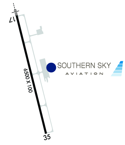
| Lat: N 3027.8 Long: W 08831.8 Elev: 17 Var: +02 Longest Runway: 6501 | ||
| Clr Del: 121.72 Dept. ATIS: 135.17 Arr. ATIS: 135.17 AWOS: 135.17 Ground: 121.72 Tower: 118.57 | ||
| |||||||||||||||||||||||||||||||||||||||||||||||||||||||||||||||||||||
| |||||||||||||||||||||||||||||||||||||||||||||||||||||||||||||||||||||
| |||||||||||||||||||||||||||||||||||||||||||||||||||||||||||||||||||||
| Rwy | Rwy | |||||||
| 6501x150 | 6501' | 110.10 - 168° | 6501x150 | 6501' | ||||
| Runway ID | Single Wheel | Double Wheel | Double Tandem Wheel | Dual Double Wheel |
| 17/35 | N/A | 196,000 | 315,000 | 753,000 |
| These numbers are Advisory and are not limits. The Airport Manager should have more accurate Weight Limits | ||||
 Airport Diagram might not be current. | |
| Facility Name: | TRENT LOTT INTL |
| City Name: | PASCAGOULA |
| County: | JACKSON |
| State abbrev: | MS |
| State Name: | MISSISSIPPI |
| Ownership: | PUBLICLY OWNED |
| Use: | OPEN TO THE PUBLIC |
| Owner's Name: | JACKSON COUNTY; REX FOSTER, JCAA CHAIRMAN. |
| Address: | 8301 SARACENNIA RD |
| MOSS POINT, MS 39563-9478 | |
| Owner's Phone: | 228-769-3089 |
| Manager's Name: | CINNAMON SNYDER |
| Address: | 8301 SARACENNIA RD, STE 11 |
| MOSS POINT, MS 39563-9478 | |
| Phone: | 228-475-1371; IFUN TO CTC AMGR CALL FBO: 228-474-1000. |
| FAA Region: | SOUTHERN |
| FAA Field Office: | JAN |
| Date | Sunrise | Sunset |
|---|---|---|
| 07/15/25 Tuesday | 6:02 | 19:58 |
| 07/16/25 Wednesday | 6:03 | 19:57 |
| 07/17/25 Thursday | 6:03 | 19:57 |
| 07/18/25 Friday | 6:04 | 19:57 |
| 07/19/25 Saturday | 6:04 | 19:56 |
| 07/20/25 Sunday | 6:05 | 19:56 |
| 07/21/25 Monday | 6:05 | 19:55 |
| 07/22/25 Tuesday | 6:06 | 19:55 |
| 07/23/25 Wednesday | 6:07 | 19:54 |
| 07/24/25 Thursday | 6:07 | 19:54 |
| 07/25/25 Friday | 6:08 | 19:53 |
| 07/26/25 Saturday | 6:08 | 19:52 |
| 07/27/25 Sunday | 6:09 | 19:52 |
| 07/28/25 Monday | 6:10 | 19:51 |
| Airport Attendance Schedule | CONTINUOUS |
| Airport Status | OPERATIONAL (This Status can change at any time - please check NOTAMS) |
| Airport Lighting Schedule | ACTVT MALSR RWY 17; PAPI RWY 35; MIRL RWY 17/35 - CTAF. |
| Airport Storage Available | Tie Downs |
| Extra Services Available | NONE |
| Wind Indicator | YES - (lighted) |
| Control Tower | YES |
| CTAF Frequency | 118.575 |
| Unicom Frequency | 122.800 |
| Rotating Beacon Color | WG |
| Segmented Circle | YES |
| Landing Fee |
| Airport Inspected | STATE - performed by STATE AERONAUTICAL PERSONNEL |
| Inspection Date | 05/16/2025 |
| Type of Fuel Available | Grade 100LL, JET A (freeze point -40C); -10MIL CONTR FUEL AVBL. |
| Airframe Repair Service | MAJOR |
| Power Plant Repair Service | MAJOR |
| Latitude | N3027.8 |
| Longitude | W08831.8 (ESTIMATED) |
| Arpt Elevation | 16ft (SURVEYED) |
| Magnetic Variation | 02W |
| 6 miles N | of PASCAGOULA |
| Traffic Pattern Altitude | |
| Sectional Chart | NEW ORLEANS |
| Operations (Reported) | Yearly | Avg. Daily |
|---|---|---|
| General Aviation Transient | 0 | 0 |
| General Aviation Local | 0 | 0 |
| Air Taxi | 0 | 0 |
| Commerical | 0 | 0 |
| Commuter | 0 | 0 |
| Military | 0 | 0 |
| Aircraft based on Field | |
|---|---|
| General Aviation Singles | 0 |
| General Aviation Multi | 0 |
| Jet Aircraft | 0 |
| General Aviation Helicopters | 0 |
| Military Aircraft | 0 |
| Gliders | 0 |
| Ultralights | 0 |
| FSS on field | NO |
| FSS tie-in | GREENWOOD |
| FSS Phone | 1-800-WX-BRIEF |
| Who issues Notams | PQL |
| Notam D service at airport | YES |
| ARTCC Name | HOUSTON |
| Airport Certification | |
| Aircraft Rescue & Firefighting Index | ARFF 24 HRS. |
| Airport of Entry | No |
| Custom Landing Rights | YES |
| Joint Civil/Military | No |
| Military Landing rights | YES |
| NATIONAL PLAN OF INTEGRATED AIRPORT SYSTEMS (NPIAS) |
| GRANT AGREEMENTS UNDER FAAP/ADAP/AIP |
| ASSURANCES PURSUANT TO TITLE VI, CIVIL RIGHTS ACT OF 1964 |
| NMRS LOW FLYING FISH SPOTTER ACFT OPRG NEAR SHORELINE BTN BAY ST LOUIS & PASCAGOULA SR-SS. |
| ARFF 24 HRS. |
| FOR CD WHEN ATCT CLSD CTC MOBILE APCH AT 251-662-6236, WHEN APCH CLSD CTC HOUSTON ARTCC AT 281-230-5622. |
| RWY 17/3 5 UNL. |
Airport Communications & Frequencies:
| |||||||||||||||||||||||||
| Runway: 17 | Runway: 35 | ||
| Mag heading: | 168° | Mag heading: | 348° |
| Rwy Slope: | .01% Up | Rwy Slope: | -.01% Down |
| Approach: | ILS/DME | Approach: | |
| Pattern: | Left Traffic | Pattern: | Left Traffic |
| Markings: | PRECISION INSTRUMENT | Markings: | NONPRECISION INSTRUMENT |
| Marking Condition: | GOOD | Marking Condition: | FAIR |
| Arresting Dev: | Arresting Dev: | ||
| Lat & Long: | N3028.3 W08831.9 | Lat. & Long.: | N3027.2 W08831.6 |
| Elev: | 15.8 ft. MSL | Elev: | 16.7 ft. MSL |
| TCH: | 50 ft. AGL | TCH: | 40 ft. AGL |
| Visual Glide Path: | 3.00 degrees | Visual Glide Path: | 3.00 degrees |
| Displaced Threshold: | No | Displaced Threshold: | No |
| Touchdown Zone: | YES | Touchdown Zone: | YES |
| Touchdown Elev.: | 16.2 feet | Touchdown Elev.: | 16.8 feet |
| Visual Glide Slope: | 4-Light PAPI on LEFT side of Runway | Visual Glide Slope: | 4-Light PAPI on LEFT side of Runway |
| RVR Equipment: | RVR Equipment: | ||
| RVV Equipment: | NO | RVV Equipment: | NO |
| Approach Lights: | MALSR - 1,400 foot medium intensity approach lighting system with runway alignment indicator lights | Approach Lights: | |
| REIL: | NO | REIL: | NO |
| Centerline Lights: | NO | Centerline Lights: | NO |
| Touchdown lights: | NO | Touchdown lights: | NO |
| Runway Category: | Precision Instrument Runway | Runway Category: | Runway with a Non-precision Approach having visibility minimums greater than 3/4 mile |
| Declared Distances: | Declared Distances: |
Thanks for using FltPlan.com
all rights reserved © 1999-2025 by Flight Plan LLC


