| POMPANO BEACH AIRPARK POMPANO BEACH FL |
| |
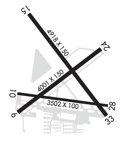
| Lat: N 2614.8 Long: W 08006.7 Elev: 19 Var: +07 Longest Runway: 4918 | ||
| Dept. ATIS: 120.55 Arr. ATIS: 120.55 Ground: 121.9 Tower: 125.4 | ||
| |||||||||||||||||||||||||||||||||||||||||||||||||||||||||||||||||||||
| |||||||||||||||||||||||||||||||||||||||||||||||||||||||||||||||||||||
| |||||||||||||||||||||||||||||||||||||||||||||||||||||||||||||||||||||
| |||||||||||||||||||||||||||||||||||||||||||||||||||||||||||||||||||||
| Rwy | Rwy | |||||||
| 4001x150 | 4001' | 4001x150 | 4001' | |||||
| 3687x100 | 3687' | 3687x100 | 3502' | |||||
| 4918x150 | 4417' | 109.75 - 149° | 4918x150 | 4578' | ||||
| Runway ID | Single Wheel | Double Wheel | Double Tandem Wheel | Dual Double Wheel |
| 06/24 | 20,000 | N/A | N/A | N/A |
| 10/28 | 26,000 | N/A | N/A | N/A |
| 15/33 | 30,000 | N/A | N/A | N/A |
| These numbers are Advisory and are not limits. The Airport Manager should have more accurate Weight Limits | ||||
 Airport Diagram might not be current. | |
| Facility Name: | POMPANO BEACH AIRPARK |
| City Name: | POMPANO BEACH |
| County: | BROWARD |
| State abbrev: | FL |
| State Name: | FLORIDA |
| Ownership: | PUBLICLY OWNED |
| Use: | OPEN TO THE PUBLIC |
| Owner's Name: | CITY OF POMPANO BEACH |
| Address: | 100 WEST ATLANTIC BOULEVARD, CITY HALL |
| POMPANO BEACH, FL 33061 | |
| Owner's Phone: | 954-786-4135 |
| Manager's Name: | STEVEN ROCCO |
| Address: | POMPANO BEACH AIRPARK, 1001 NORTHEAST 10TH STREET |
| POMPANO BEACH, FL 33060 | |
| Phone: | 954-786-4135 |
| FAA Region: | SOUTHERN |
| FAA Field Office: | ORL |
| Date | Sunrise | Sunset |
|---|---|---|
| 04/28/26 Tuesday | 6:46 | 19:51 |
| 04/29/26 Wednesday | 6:45 | 19:51 |
| 04/30/26 Thursday | 6:44 | 19:52 |
| 05/01/26 Friday | 6:43 | 19:52 |
| 05/02/26 Saturday | 6:42 | 19:53 |
| 05/03/26 Sunday | 6:42 | 19:53 |
| 05/04/26 Monday | 6:41 | 19:54 |
| 05/05/26 Tuesday | 6:40 | 19:54 |
| 05/06/26 Wednesday | 6:40 | 19:55 |
| 05/07/26 Thursday | 6:39 | 19:55 |
| 05/08/26 Friday | 6:38 | 19:56 |
| 05/09/26 Saturday | 6:38 | 19:57 |
| 05/10/26 Sunday | 6:37 | 19:57 |
| 05/11/26 Monday | 6:36 | 19:58 |
| Airport Attendance Schedule | CONTINUOUS |
| Airport Status | OPERATIONAL (This Status can change at any time - please check NOTAMS) |
| Airport Lighting Schedule | REIL RWY 06 & 24, 33; PAPI RWY 10 & 28 OPR DUSK TO DAWN. WHEN ATCT CLSD ACTVT MALS RWY 15 - CTAF. MIRL RWY 15/33 & RWY MOST ALIGNED TO WIND PRESET MED INTST ONLY. |
| Airport Storage Available | Tie Downs, Hanger |
| Extra Services Available | Air Ambulance, Avionics, Charter, Flight Instruction, Aircraft Rental, Aircraft Sales |
| Wind Indicator | YES - (lighted) |
| Control Tower | YES |
| CTAF Frequency | 125.400 |
| Unicom Frequency | 122.950 |
| Rotating Beacon Color | WG |
| Segmented Circle | NO |
| Landing Fee | NO |
| Airport Inspected | STATE - performed by STATE AERONAUTICAL PERSONNEL |
| Inspection Date | 05/14/2024 |
| Type of Fuel Available | Grade 100LL, JET A (freeze point -40C) |
| Airframe Repair Service | MAJOR |
| Power Plant Repair Service | MAJOR |
| Latitude | N2614.8 |
| Longitude | W08006.7 (ESTIMATED) |
| Arpt Elevation | 19ft (SURVEYED) |
| Magnetic Variation | 07W |
| 1 miles NE | of POMPANO BEACH |
| Traffic Pattern Altitude | 800 |
| Sectional Chart | MIAMI |
| Operations (Reported) | Yearly | Avg. Daily |
|---|---|---|
| General Aviation Transient | 0 | 0 |
| General Aviation Local | 0 | 0 |
| Air Taxi | 0 | 0 |
| Commerical | 0 | 0 |
| Commuter | 0 | 0 |
| Military | 0 | 0 |
| Aircraft based on Field | |
|---|---|
| General Aviation Singles | 0 |
| General Aviation Multi | 0 |
| Jet Aircraft | 0 |
| General Aviation Helicopters | 0; BELL HEL SVC CTR ON ARPT. |
| Military Aircraft | 0 |
| Gliders | 0 |
| Ultralights | 0 |
| FSS on field | NO |
| FSS tie-in | MIAMI |
| FSS Phone | 1-800-WX-BRIEF |
| Who issues Notams | PMP |
| Notam D service at airport | YES |
| ARTCC Name | MIAMI |
| Airport Certification | |
| Aircraft Rescue & Firefighting Index | None |
| Airport of Entry | No |
| Custom Landing Rights | No |
| Joint Civil/Military | No |
| Military Landing rights | YES |
| NATIONAL PLAN OF INTEGRATED AIRPORT SYSTEMS (NPIAS) |
| SURPLUS PROPERTY AGREEMENT UNDER PUBLIC LAW 289 |
| SURPLUS PROPERTY AGREEMENT UNDER REGULATION 16-WAA |
| ADVANCE PLANNING AGREEMENT UNDER FAAP |
| ASSURANCES PURSUANT TO TITLE VI, CIVIL RIGHTS ACT OF 1964 |
| NMRS BIRDS ON & INVOF ARPT. |
| ALL RWYS NOISE SENSITIVE ALL QUADRANTS; CTC AMGR FOR HEL & FIXED WING OPS. TGL OPNS PMTD MON-FRI 0900-1800 AND LTD AS POSS ON WKENDS AND LEGAL HOLS. STOP AND GO OPNS AND INTERSECTION TKOFS STGLY DISCOURAGED AT ALL TIMES. |
| FOR CD WHEN ATCT CLSD CTC MIAMI APCH AT 305-869-5432. |
| ACFT WITH GWT MORE THAN 30000 LBS PPR ON RWY 15/33. ACFT EXCEEDING 12500 PROHIBITED ON RWY 10/28. |
| RWY 06/2 4 LTD TO GWT 12500 LBS OR LESS. |
| RWY 10/2 8 LTD TO GWT 12500 LBS OR LESS. |
| RWY 15/3 3 LTD TO GWT 30000 LBS OR LESS. |
Airport Communications & Frequencies:
| |||||||||||||||||||||||
| Runway: 06 | Runway: 24 | ||
| Mag heading: | 60° | Mag heading: | 240° |
| Rwy Slope: | -.16% Down | Rwy Slope: | .16% Up |
| Approach: | Approach: | ||
| Pattern: | Left Traffic | Pattern: | Left Traffic |
| Markings: | BASIC | Markings: | BASIC |
| Marking Condition: | FAIR | Marking Condition: | FAIR |
| Arresting Dev: | Arresting Dev: | ||
| Lat & Long: | N2614.6 W08007.0 | Lat. & Long.: | N2615.0 W08006.4 |
| Elev: | 19.3 ft. MSL | Elev: | 12.9 ft. MSL |
| TCH: | 45 ft. AGL | TCH: | 49 ft. AGL |
| Visual Glide Path: | 3.75 degrees | Visual Glide Path: | 3.50 degrees |
| Displaced Threshold: | No | Displaced Threshold: | No |
| Touchdown Zone: | YES | Touchdown Zone: | YES |
| Touchdown Elev.: | 19.3 feet | Touchdown Elev.: | 17.6 feet |
| Visual Glide Slope: | 2-Light PAPI on LEFT side of Runway | Visual Glide Slope: | 2-Light PAPI on LEFT side of Runway |
| RVR Equipment: | RVR Equipment: | ||
| RVV Equipment: | NO | RVV Equipment: | NO |
| Approach Lights: | Approach Lights: | ||
| REIL: | YES | REIL: | YES |
| Centerline Lights: | NO | Centerline Lights: | NO |
| Touchdown lights: | NO | Touchdown lights: | NO |
| Runway Category: | Runway with a Non-precision Approach | Runway Category: | Runway with a Non-precision Approach |
| Declared Distances: | Declared Distances: | ||
| Obstructions: | TREES | Obstructions: | TREES |
| Marked: | NOT Marked/Lighted | Marked: | NOT Marked/Lighted |
| Clearance slope: | 16:1 | Clearance slope: | 20:1 |
| Obstruction height: | 40 feet AGL | Obstruction height: | 59 feet AGL |
| Dist. from runway: | 845 feet | Dist. from runway: | 1395 feet |
| Centerline offset: | 225 left of centerline | Centerline offset: | 150 feet left of centerline |
| Comments: | Comments: |
| Runway: 10 | Runway: 28 | ||
| Mag heading: | 105° | Mag heading: | 285° |
| Rwy Slope: | -.21% Down | Rwy Slope: | .21% Up |
| Approach: | Approach: | ||
| Pattern: | Left Traffic | Pattern: | Left Traffic |
| Markings: | BASIC | Markings: | BASIC |
| Marking Condition: | FAIR | Marking Condition: | FAIR |
| Arresting Dev: | Arresting Dev: | ||
| Lat & Long: | N2614.8 W08007.0 | Lat. & Long.: | N2614.7 W08006.3 |
| Elev: | 18.3 ft. MSL | Elev: | 10.7 ft. MSL |
| TCH: | 42 ft. AGL | TCH: | 53 ft. AGL |
| Visual Glide Path: | 3.75 degrees | Visual Glide Path: | 3.90 degrees |
| Displaced Threshold: | No | Displaced Threshold: | 185 feet |
| Touchdown Zone: | YES | Touchdown Zone: | YES |
| Touchdown Elev.: | 18.4 feet | Touchdown Elev.: | 17.6 feet |
| Visual Glide Slope: | 2-Light PAPI on LEFT side of Runway | Visual Glide Slope: | 2-Light PAPI on LEFT side of Runway |
| RVR Equipment: | RVR Equipment: | ||
| RVV Equipment: | NO | RVV Equipment: | NO |
| Approach Lights: | Approach Lights: | ||
| REIL: | YES | REIL: | YES |
| Centerline Lights: | NO | Centerline Lights: | NO |
| Touchdown lights: | NO | Touchdown lights: | NO |
| Runway Category: | Runway with a Visual Approach | Runway Category: | Runway with a Visual Approach |
| Declared Distances: | Declared Distances: | ||
| Obstructions: | TREE | Obstructions: | TREES |
| Marked: | NOT Marked/Lighted | Marked: | NOT Marked/Lighted |
| Clearance slope: | 19:1 | Clearance slope: | 16:1 |
| Obstruction height: | 37 feet AGL | Obstruction height: | 31 feet AGL |
| Dist. from runway: | 925 feet | Dist. from runway: | 725 feet |
| Centerline offset: | 90 right of centerline | Centerline offset: | 30 feet right of centerline |
| Comments: | Comments: |
| Runway: 15 | Runway: 33 | ||
| Mag heading: | 150° | Mag heading: | 330° |
| Rwy Slope: | -.08% Down | Rwy Slope: | .08% Up |
| Approach: | LOC/DME | Approach: | |
| Pattern: | Left Traffic | Pattern: | Left Traffic |
| Markings: | NONPRECISION INSTRUMENT | Markings: | NONPRECISION INSTRUMENT |
| Marking Condition: | FAIR | Marking Condition: | FAIR |
| Arresting Dev: | Arresting Dev: | ||
| Lat & Long: | N2615.3 W08006.9 | Lat. & Long.: | N2614.6 W08006.4 |
| Elev: | 16.5 ft. MSL | Elev: | 12.6 ft. MSL |
| TCH: | 39 ft. AGL | TCH: | 53 ft. AGL |
| Visual Glide Path: | 3.00 degrees | Visual Glide Path: | 3.00 degrees |
| Displaced Threshold: | 501 feet | Displaced Threshold: | 340 feet |
| Touchdown Zone: | YES | Touchdown Zone: | YES |
| Touchdown Elev.: | 16.4 feet | Touchdown Elev.: | 15.9 feet |
| Visual Glide Slope: | 4-Light PAPI on LEFT side of Runway | Visual Glide Slope: | 4-Light PAPI on LEFT side of Runway |
| RVR Equipment: | RVR Equipment: | ||
| RVV Equipment: | NO | RVV Equipment: | NO |
| Approach Lights: | MALS - 1,400 foot medium intensity approach lighting system | Approach Lights: | |
| REIL: | NO | REIL: | YES |
| Centerline Lights: | NO | Centerline Lights: | NO |
| Touchdown lights: | NO | Touchdown lights: | NO |
| Runway Category: | D | Runway Category: | D |
| Declared Distances: | Declared Distances: | ||
| Obstructions: | HILL | Obstructions: | TREES |
| Marked: | NOT Marked/Lighted | Marked: | NOT Marked/Lighted |
| Clearance slope: | CTLG OBSTN EXCEEDS A 45 DEG SLP. APCH SLP 34:1 FM DTHR. | Clearance slope: | 17:1; APCH SLP 34:1 TO DTHR. |
| Obstruction height: | 5 feet AGL | Obstruction height: | 32 feet AGL |
| Dist. from runway: | 201 feet | Dist. from runway: | 750 feet |
| Centerline offset: | 425 right of centerline | Centerline offset: | 450 feet left of centerline |
| Comments: | RWY 15 HAS BLDG 55 FT BFR AER AND 359 FT R OF CL. | Comments: |
Thanks for using FltPlan.com
all rights reserved © 1999-2026 by Flight Plan LLC