
| NEWPORT NEWS/WILLIAMSBURG INTL NEWPORT NEWS VA |
| |
| Lat: N 3707.9 Long: W 07629.6 Elev: 42 Var: +09 Longest Runway: 8003 | ||
| Clr Del: 121.65/124.9 Dept. ATIS: 128.65 Arr. ATIS: 128.65 Ground: 121.9 Tower: 118.7 | ||
| |||||||||||||||||||||||||||||||||||||||||||||||||||||||||||||||||||||
| |||||||||||||||||||||||||||||||||||||||||||||||||||||||||||||||||||||
| |||||||||||||||||||||||||||||||||||||||||||||||||||||||||||||||||||||
| |||||||||||||||||||||||||||||||||||||||||||||||||||||||||||||||||||||
| Rwy | Rwy | |||||||
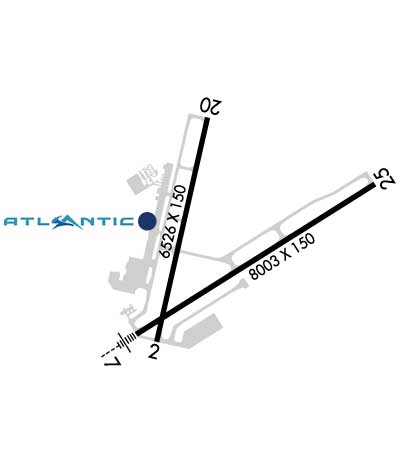
| 6526x150 | 6526' | 6526x150 | 6526' | 109.30 - 201° | ||||
| 8003x150 | 8003' | 110.10 - 066° | 8003x150 | 8003' | 110.10 - 246° | |||
| Runway ID | Single Wheel | Double Wheel | Double Tandem Wheel | Dual Double Wheel |
| 02/20 | 100,000 | 200,000 | 350,000 | N/A |
| 07/25 | 100,000 | 200,000 | 350,000 | N/A |
| These numbers are Advisory and are not limits. The Airport Manager should have more accurate Weight Limits | ||||
 Airport Diagram might not be current. | |
| Facility Name: | NEWPORT NEWS/WILLIAMSBURG INTL |
| City Name: | NEWPORT NEWS |
| County: | NEWPORT NEWS |
| State abbrev: | VA |
| State Name: | VIRGINIA |
| Ownership: | PUBLICLY OWNED |
| Use: | OPEN TO THE PUBLIC |
| Owner's Name: | PENINSULA ARPT CMSN |
| Address: | 900 BLAND BLVD, SUITE G |
| NEWPORT NEWS, VA 23602 | |
| Owner's Phone: | 757-877-0221 |
| Manager's Name: | MICHAEL A. GIARDINO |
| Address: | 900 BLAND BLVD, SUITE G |
| NEWPORT NEWS, VA 23602 | |
| Phone: | 757-877-0221 |
| FAA Region: | EASTERN |
| FAA Field Office: | DCA |
| Date | Sunrise | Sunset |
|---|---|---|
| 09/24/21 Friday | 6:55 | 19:00 |
| 09/25/21 Saturday | 6:56 | 18:59 |
| 09/26/21 Sunday | 6:57 | 18:57 |
| 09/27/21 Monday | 6:58 | 18:56 |
| 09/28/21 Tuesday | 6:59 | 18:54 |
| 09/29/21 Wednesday | 6:59 | 18:53 |
| 09/30/21 Thursday | 7:00 | 18:51 |
| 10/01/21 Friday | 7:01 | 18:50 |
| 10/02/21 Saturday | 7:02 | 18:48 |
| 10/03/21 Sunday | 7:03 | 18:47 |
| 10/04/21 Monday | 7:04 | 18:45 |
| 10/05/21 Tuesday | 7:05 | 18:44 |
| 10/06/21 Wednesday | 7:05 | 18:42 |
| 10/07/21 Thursday | 7:06 | 18:41 |
| Airport Attendance Schedule | CONTINUOUS |
| Airport Status | OPERATIONAL (This Status can change at any time - please check NOTAMS) |
| Airport Lighting Schedule | ACTVT MALSR RWY 07; REIL RWY 20; PAPI RWY 02/20; HIRL RWY 02/20 ; REIL RWY 25; PAPI RWY 25; HIRL RWY 07/25 AND TWY LGTS - CTAF. |
| Airport Storage Available | Tie Downs, Hanger |
| Extra Services Available | Avionics, Cargo Handling, Charter, Flight Instruction, Aircraft Rental, Aircraft Sales |
| Wind Indicator | YES - (lighted) |
| Control Tower | YES |
| CTAF Frequency | 118.700 |
| Unicom Frequency | 122.950 |
| Rotating Beacon Color | CLEAR-GREEN (Light Land Airport) |
| Segmented Circle | NO |
| Landing Fee | YES; LANDING FEE FOR ACFT OVER 12500 LBS. |
| Airport Inspected | FEDERAL - performed by FAA AIRPORTS FIELD PERSONNEL |
| Inspection Date | 03/15/2021 |
| Type of Fuel Available | Grade 100LL, JET A (freeze point -40C) |
| Airframe Repair Service | MAJOR |
| Power Plant Repair Service | MAJOR |
| Latitude | N3707.9 |
| Longitude | W07629.6 (ESTIMATED) |
| Arpt Elevation | 42ft (SURVEYED) |
| Magnetic Variation | 09W |
| 9 miles NW | of NEWPORT NEWS |
| Traffic Pattern Altitude | |
| Sectional Chart | WASHINGTON |
| Operations (Reported) | Yearly | Avg. Daily |
|---|---|---|
| General Aviation Transient | 12728 | 35 |
| General Aviation Local | 6899 | 19 |
| Air Taxi | 3695 | 10 |
| Commerical | 2263 | 6 |
| Commuter | 0 | 0 |
| Military | 13650 | 37 |
| Aircraft based on Field | |
|---|---|
| General Aviation Singles | 76 |
| General Aviation Multi | 26 |
| Jet Aircraft | 25 |
| General Aviation Helicopters | 0 |
| Military Aircraft | 0 |
| Gliders | 0 |
| Ultralights | 0 |
| FSS on field | NO |
| FSS tie-in | LEESBURG |
| FSS Phone | 1-800-WX-BRIEF |
| Who issues Notams | PHF |
| Notam D service at airport | YES |
| ARTCC Name | WASHINGTON |
| Airport Certification | AIRPORT RECEIVING SCHEDULED AIR CARRIER SERVICE FROM CARRIERS CERTIFICATED BY THE CIVIL AERONAUTICS BOARD; PPR 45 MINUTES FOR UNSKED AIR CARRIER OPNS WITH MORE THAN 30 PSGR SEATS CALL AIRPORT OPERATIONS 757-234-0568. |
| Aircraft Rescue & Firefighting Index | AIRPORT HAS A CERTIFICATE UNDER CFR PART 139 |
| Airport of Entry | No |
| Custom Landing Rights | YES |
| Joint Civil/Military | No |
| Military Landing rights | YES |
| NATIONAL PLAN OF INTEGRATED AIRPORT SYSTEMS (NPIAS) |
| GRANT AGREEMENTS UNDER FAAP/ADAP/AIP |
| SURPLUS PROPERTY AGREEMENT UNDER PUBLIC LAW 289 |
| CONVEYANCE UNDER SCETION 16, FEDERAL AIRPORT ACT OF 1946 OR SECTION 23, AIRPORT AND AIRWAY DEVELOPMENT ACT OF 1970 |
| ASSURANCES PURSUANT TO TITLE VI, CIVIL RIGHTS ACT OF 1964 |
| BIRDS INVOF ARPT. |
| GLIDER ACTIVITY APPROX 19 MILES SW OF ARPT UP TO BASE OF CLOUDS. |
| ACFT ARRIVING/DEPARTING NEWPORT NEWS SHOULD ANNOUNCE INTENTIONS ON CTAF WHEN ATCT CLSD. |
| RWY 02/2 0 (CONC-GRVD FM AER 20 TO 5000 FT. REMAINDER ASPHALT-GRVD) |
Airport Communications & Frequencies:
| ||||||||||||||||||||||||||||||||||||||
| Runway: 02 | Runway: 20 | ||
| Mag heading: | 22° | Mag heading: | 202° |
| Rwy Slope: | .07% Up | Rwy Slope: | -.07% Down |
| Approach: | Approach: | LOC/DME | |
| Pattern: | Left Traffic | Pattern: | Left Traffic |
| Markings: | NONPRECISION INSTRUMENT | Markings: | NONPRECISION INSTRUMENT |
| Marking Condition: | GOOD | Marking Condition: | GOOD |
| Arresting Dev: | Arresting Dev: | ||
| Lat & Long: | N3707.5 W07630.0 | Lat. & Long.: | N3708.5 W07629.7 |
| Elev: | 37.3 ft. MSL | Elev: | 42.1 ft. MSL |
| TCH: | 53 ft. AGL | TCH: | 43 ft. AGL |
| Visual Glide Path: | 3.00 degrees | Visual Glide Path: | 3.00 degrees |
| Displaced Threshold: | No | Displaced Threshold: | No |
| Touchdown Zone: | YES | Touchdown Zone: | YES |
| Touchdown Elev.: | 38.4 feet | Touchdown Elev.: | 42.2 feet |
| Visual Glide Slope: | 4-Light PAPI on LEFT side of Runway | Visual Glide Slope: | 4-Light PAPI on LEFT side of Runway |
| RVR Equipment: | RVR Equipment: | ||
| RVV Equipment: | NO | RVV Equipment: | NO |
| Approach Lights: | Approach Lights: | ||
| REIL: | NO | REIL: | YES |
| Centerline Lights: | NO | Centerline Lights: | NO |
| Touchdown lights: | NO | Touchdown lights: | NO |
| Runway Category: | Runway with a Non-precision Approach having visibility minimums greater than 3/4 mile | Runway Category: | Runway with a Non-precision Approach having visibility minimums greater than 3/4 mile |
| Declared Distances: | TORA:6526' TODA:6526' ASDA:6526' LDA:6526' | Declared Distances: | TORA:6526' TODA:6526' ASDA:6526' LDA:6526' |
| Obstructions: | Obstructions: | ROAD | |
| Marked: | Marked: | NOT Marked/Lighted | |
| Clearance slope: | 50:1 | Clearance slope: | 36:1 |
| Obstruction height: | Obstruction height: | 23 feet AGL | |
| Dist. from runway: | Dist. from runway: | 1050 feet | |
| Centerline offset: | Centerline offset: | ||
| Comments: | Comments: |
| Runway: 07 | Runway: 25 | ||
| Mag heading: | 67° | Mag heading: | 247° |
| Rwy Slope: | .02% Up | Rwy Slope: | -.02% Down |
| Approach: | ILS/DME | Approach: | ILS/DME |
| Pattern: | Left Traffic | Pattern: | Left Traffic |
| Markings: | PRECISION INSTRUMENT | Markings: | PRECISION INSTRUMENT |
| Marking Condition: | GOOD | Marking Condition: | GOOD |
| Arresting Dev: | Arresting Dev: | ||
| Lat & Long: | N3707.5 W07630.1 | Lat. & Long.: | N3708.2 W07628.7 |
| Elev: | 37.2 ft. MSL | Elev: | 39.2 ft. MSL |
| TCH: | TCH: | 71 ft. AGL | |
| Visual Glide Path: | Visual Glide Path: | 3.00 degrees | |
| Displaced Threshold: | No | Displaced Threshold: | No |
| Touchdown Zone: | YES | Touchdown Zone: | YES |
| Touchdown Elev.: | 39.7 feet | Touchdown Elev.: | 41.2 feet |
| Visual Glide Slope: | Visual Glide Slope: | 4-Light PAPI on RIGHT side of Runway | |
| RVR Equipment: | TOUCHDOWN | RVR Equipment: | ROLLOUT |
| RVV Equipment: | YES | RVV Equipment: | NO |
| Approach Lights: | MALSR - 1,400 foot medium intensity approach lighting system with runway alignment indicator lights; MALSR UNMONITORED. | Approach Lights: | |
| REIL: | NO | REIL: | YES |
| Centerline Lights: | NO | Centerline Lights: | NO |
| Touchdown lights: | NO | Touchdown lights: | NO |
| Runway Category: | Precision Instrument Runway | Runway Category: | Precision Instrument Runway |
| Declared Distances: | TORA:8003' TODA:8003' ASDA:8003' LDA:8003' | Declared Distances: | TORA:8003' TODA:8003' ASDA:8003' LDA:8003' |
| Obstructions: | TREES | Obstructions: | TREES |
| Marked: | NOT Marked/Lighted | Marked: | NOT Marked/Lighted |
| Clearance slope: | 36:1 | Clearance slope: | 21:1 |
| Obstruction height: | 69 feet AGL | Obstruction height: | 41 feet AGL |
| Dist. from runway: | 2700 feet | Dist. from runway: | 1100 feet |
| Centerline offset: | 350 left of centerline | Centerline offset: | 300 feet left of centerline |
| Comments: | Comments: |
Thanks for using FltPlan.com
all rights reserved © 1999-2021 by Flight Plan LLC