
| OAKLEY MUNI OAKLEY KS |
| |
| Lat: N 3906.7 Long: W 10049.0 Elev: 3045 Var: -08 Longest Runway: 5000 | ||
| AWOS: 118.32 CTAF: 122.8 | ||
| ||||||||||||||||||||||||||||||||||||||||||||
| ||||||||||||||||||||||||||||||||||||||||||||
| ||||||||||||||||||||||||||||||||||||||||||||
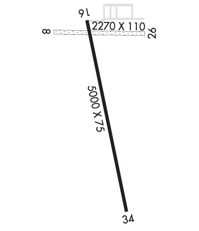
| Rwy | Rwy | |||||||
| 2153x110 | 2153' | 2153x110 | 2153' | |||||
| 5000x75 | 5000' | 5000x75 | 5000' | |||||
| Runway ID | Single Wheel | Double Wheel | Double Tandem Wheel | Dual Double Wheel |
| 08/26 | N/A | N/A | N/A | N/A |
| 16/34 | 30,000 | N/A | N/A | N/A |
| These numbers are Advisory and are not limits. The Airport Manager should have more accurate Weight Limits | ||||
 Airport Diagram might not be current. | |
| Facility Name: | OAKLEY MUNI |
| City Name: | OAKLEY |
| County: | LOGAN |
| State abbrev: | KS |
| State Name: | KANSAS |
| Ownership: | PUBLICLY OWNED |
| Use: | OPEN TO THE PUBLIC |
| Owner's Name: | CITY OF OAKLEY |
| Address: | CITY HALL, 209 HUDSON AVE |
| OAKLEY, KS 67748 | |
| Owner's Phone: | 785-671-3136 |
| Manager's Name: | JOHN HOLZMEISTER |
| Address: | CITY HALL, 209 HUDSON AVE |
| OAKLEY, KS 67748-6016 | |
| Phone: | 785-672-0147; JHOLZMEISTER@FRONTIERAGINC.COM |
| FAA Region: | CENTRAL |
| FAA Field Office: | NONE |
| Date | Sunrise | Sunset |
|---|---|---|
| 07/15/25 Tuesday | 6:29 | 21:09 |
| 07/16/25 Wednesday | 6:30 | 21:08 |
| 07/17/25 Thursday | 6:31 | 21:07 |
| 07/18/25 Friday | 6:32 | 21:07 |
| 07/19/25 Saturday | 6:32 | 21:06 |
| 07/20/25 Sunday | 6:33 | 21:05 |
| 07/21/25 Monday | 6:34 | 21:05 |
| 07/22/25 Tuesday | 6:35 | 21:04 |
| 07/23/25 Wednesday | 6:36 | 21:03 |
| 07/24/25 Thursday | 6:37 | 21:02 |
| 07/25/25 Friday | 6:37 | 21:02 |
| 07/26/25 Saturday | 6:38 | 21:01 |
| 07/27/25 Sunday | 6:39 | 21:00 |
| 07/28/25 Monday | 6:40 | 20:59 |
| Airport Attendance Schedule | MON-FRI 0800-1700 |
| Airport Status | OPERATIONAL (This Status can change at any time - please check NOTAMS) |
| Airport Lighting Schedule | PAPI RWY 16/34 - CTAF. DUSK-2230. MIRL RWY 16/34 PRESET LOW INTST DUSK-2230; TO INCR INTST - CTAF; AFTER 2230 ACTVT MIRL RWY 16/34 - CTAF. |
| Airport Storage Available | Tie Downs, Hanger |
| Extra Services Available | Crop Dusting, Flight Instruction |
| Wind Indicator | YES - (lighted) |
| Control Tower | NO |
| CTAF Frequency | 122.800 |
| Unicom Frequency | 122.800 |
| Rotating Beacon Color | WG |
| Segmented Circle | YES |
| Landing Fee | NO |
| Airport Inspected | STATE - performed by STATE AERONAUTICAL PERSONNEL |
| Inspection Date | 09/21/2022 |
| Type of Fuel Available | Grade 100LL, JET A (freeze point -40C) |
| Airframe Repair Service | MAJOR |
| Power Plant Repair Service | MAJOR |
| Latitude | N3906.7 |
| Longitude | W10049.0 (ESTIMATED) |
| Arpt Elevation | 3045ft (SURVEYED) |
| Magnetic Variation | 08E |
| 2 miles SE | of OAKLEY |
| Traffic Pattern Altitude | |
| Sectional Chart | WICHITA |
| Operations (Reported) | Yearly | Avg. Daily |
|---|---|---|
| General Aviation Transient | 0 | 0 |
| General Aviation Local | 0 | 0 |
| Air Taxi | 0 | 0 |
| Commerical | 0 | 0 |
| Commuter | 0 | 0 |
| Military | 0 | 0 |
| Aircraft based on Field | |
|---|---|
| General Aviation Singles | 0 |
| General Aviation Multi | 0 |
| Jet Aircraft | 0 |
| General Aviation Helicopters | 0 |
| Military Aircraft | 0 |
| Gliders | 0 |
| Ultralights | 0 |
| FSS on field | NO |
| FSS tie-in | WICHITA |
| FSS Phone | 1-800-WX-BRIEF |
| Who issues Notams | ICT |
| Notam D service at airport | YES |
| ARTCC Name | DENVER |
| Airport Certification | |
| Aircraft Rescue & Firefighting Index | None |
| Airport of Entry | No |
| Custom Landing Rights | No |
| Joint Civil/Military | No |
| Military Landing rights | YES |
| NATIONAL PLAN OF INTEGRATED AIRPORT SYSTEMS (NPIAS) |
| GRANT AGREEMENTS UNDER FAAP/ADAP/AIP |
| ASSURANCES PURSUANT TO TITLE VI, CIVIL RIGHTS ACT OF 1964 |
| PUBLIC PHONE AVBL. |
| SELF SVC FUEL AVBL 24 HRS WITH CREDIT CARD. |
| FOR SVC AFTER HRS CALL 785-672-0147. |
| FOR CD CTC DENVER ARTCC AT 303-651-4257. |
Airport Communications & Frequencies:
| |||||||||
| Runway: 08 | Runway: 26 | ||
| Mag heading: | 83° | Mag heading: | 263° |
| Rwy Slope: | -.10% Down | Rwy Slope: | .10% Up |
| Approach: | Approach: | ||
| Pattern: | Left Traffic | Pattern: | Left Traffic |
| Markings: | NONE | Markings: | NONE |
| Marking Condition: | FAIR | Marking Condition: | FAIR |
| Arresting Dev: | Arresting Dev: | ||
| Lat & Long: | N3907.0 W10049.3 | Lat. & Long.: | N3907.0 W10048.8 |
| Elev: | 3042.0 ft. MSL | Elev: | 3039.9 ft. MSL |
| TCH: | TCH: | ||
| Visual Glide Path: | Visual Glide Path: | ||
| Displaced Threshold: | No | Displaced Threshold: | No |
| Touchdown Zone: | YES | Touchdown Zone: | YES |
| Touchdown Elev.: | 3043.9 feet | Touchdown Elev.: | 3043.9 feet |
| Visual Glide Slope: | Visual Glide Slope: | ||
| RVR Equipment: | RVR Equipment: | ||
| RVV Equipment: | NO | RVV Equipment: | NO |
| Approach Lights: | Approach Lights: | ||
| REIL: | NO | REIL: | NO |
| Centerline Lights: | NO | Centerline Lights: | NO |
| Touchdown lights: | NO | Touchdown lights: | NO |
| Runway Category: | Runway with a Visual Approach | Runway Category: | Runway with a Visual Approach |
| Declared Distances: | Declared Distances: | ||
| Obstructions: | OTHER; C.PIVOT 63 FT HD CNTR OFF RWY. | Obstructions: | ROAD |
| Marked: | NOT Marked/Lighted | Marked: | NOT Marked/Lighted |
| Clearance slope: | 2:1 | Clearance slope: | 15:1 |
| Obstruction height: | 25 feet AGL | Obstruction height: | 17 feet AGL |
| Dist. from runway: | 63 feet | Dist. from runway: | 255 feet |
| Centerline offset: | Centerline offset: | ||
| Comments: | Comments: |
| Runway: 16 | Runway: 34 | ||
| Mag heading: | 161° | Mag heading: | 341° |
| Rwy Slope: | -.50% Down | Rwy Slope: | .50% Up |
| Approach: | Approach: | ||
| Pattern: | Left Traffic | Pattern: | Left Traffic |
| Markings: | NONPRECISION INSTRUMENT | Markings: | NONPRECISION INSTRUMENT |
| Marking Condition: | GOOD | Marking Condition: | GOOD |
| Arresting Dev: | Arresting Dev: | ||
| Lat & Long: | N3907.0 W10049.1 | Lat. & Long.: | N3906.2 W10048.9 |
| Elev: | 3045.2 ft. MSL | Elev: | 3020.3 ft. MSL |
| TCH: | 44 ft. AGL | TCH: | 44 ft. AGL |
| Visual Glide Path: | 3.00 degrees | Visual Glide Path: | 3.00 degrees |
| Displaced Threshold: | No | Displaced Threshold: | No |
| Touchdown Zone: | YES | Touchdown Zone: | YES |
| Touchdown Elev.: | 3045.2 feet | Touchdown Elev.: | 3035.3 feet |
| Visual Glide Slope: | 2-Light PAPI on LEFT side of Runway; PAPI UNUSBL BYD 8 DEG RIGHT AND 6 DEG LEFT OF CNTRLN. | Visual Glide Slope: | 2-Light PAPI on LEFT side of Runway; PAPI UNUSBL BYD 8 DEG LEFT OF CNTRLN. |
| RVR Equipment: | RVR Equipment: | ||
| RVV Equipment: | NO | RVV Equipment: | NO |
| Approach Lights: | Approach Lights: | ||
| REIL: | YES | REIL: | YES |
| Centerline Lights: | NO | Centerline Lights: | NO |
| Touchdown lights: | NO | Touchdown lights: | NO |
| Runway Category: | Runway with a Visual Approach | Runway Category: | Runway with a Non-precision Approach having visibility minimums greater than 3/4 mile |
| Declared Distances: | TORA:5000' TODA:5000' ASDA:5000' LDA:5000' | Declared Distances: | TORA:5000' TODA:5000' ASDA:5000' LDA:5000' |
| Obstructions: | BLDG | Obstructions: | TREE |
| Marked: | NOT Marked/Lighted | Marked: | NOT Marked/Lighted |
| Clearance slope: | 18:1 | Clearance slope: | 2:1 |
| Obstruction height: | 30 feet AGL | Obstruction height: | 25 feet AGL |
| Dist. from runway: | 740 feet | Dist. from runway: | 260 feet |
| Centerline offset: | 280 left of centerline | Centerline offset: | 250 feet right of centerline |
| Comments: | Comments: |
Thanks for using FltPlan.com
all rights reserved © 1999-2025 by Flight Plan LLC