
| WILLIAMSON COUNTY RGNL MARION IL |
| |
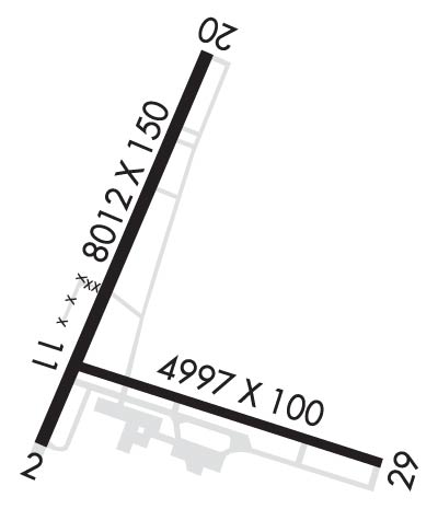
| Lat: N 3745.3 Long: W 08900.7 Elev: 472 Var: -01 Longest Runway: 8012 | ||
| Clr Del: 127.47 TW CLD AWOS: 119.67 Ground: 121.7 Tower: 128.4 | ||
| ||||||||||||||||||||||||||||||||||||||||||||||||||||||||||||||||||||
| ||||||||||||||||||||||||||||||||||||||||||||||||||||||||||||||||||||
| ||||||||||||||||||||||||||||||||||||||||||||||||||||||||||||||||||||
| Rwy | Rwy | |||||||
| 8012x150 | 8012' | 8012x150 | 8012' | 109.30 - 201° | ||||
| 4997x100 | 4997' | 4997x100 | 4997' | |||||
| Runway ID | Single Wheel | Double Wheel | Double Tandem Wheel | Dual Double Wheel |
| 02/20 | 80,000 | 95,000 | 140,000 | N/A |
| 11/29 | 45,000 | 55,000 | 100,000 | N/A |
| These numbers are Advisory and are not limits. The Airport Manager should have more accurate Weight Limits | ||||
 Airport Diagram might not be current. | |
| Facility Name: | VETERANS AIRPORT OF SOUTHERN ILLINOIS |
| City Name: | MARION |
| County: | WILLIAMSON |
| State abbrev: | IL |
| State Name: | ILLINOIS |
| Ownership: | PUBLICLY OWNED |
| Use: | OPEN TO THE PUBLIC |
| Owner's Name: | WILLIAMSON COUNTY ARPT AUTH |
| Address: | 10400 TERMINAL DR |
| MARION, IL 62959 | |
| Owner's Phone: | 618-993-3353 |
| Manager's Name: | DOUGLAS S KIMMEL |
| Address: | 10400 TERMINAL DR; SUITE 200; EMAIL ADDRESS: AIRPORT1@MIDWEST.NET (ALL LOWER CASE) |
| MARION, IL 62959 | |
| Phone: | 618-993-3353; M-F 1500-2300Z 618-993-3353; AFT HR- 618-889-3900. |
| FAA Region: | GREAT LAKES |
| FAA Field Office: | CHI |
| Date | Sunrise | Sunset |
|---|---|---|
| 03/31/26 Tuesday | 6:43 | 19:18 |
| 04/01/26 Wednesday | 6:42 | 19:19 |
| 04/02/26 Thursday | 6:40 | 19:20 |
| 04/03/26 Friday | 6:39 | 19:21 |
| 04/04/26 Saturday | 6:37 | 19:22 |
| 04/05/26 Sunday | 6:36 | 19:22 |
| 04/06/26 Monday | 6:34 | 19:23 |
| 04/07/26 Tuesday | 6:33 | 19:24 |
| 04/08/26 Wednesday | 6:31 | 19:25 |
| 04/09/26 Thursday | 6:30 | 19:26 |
| 04/10/26 Friday | 6:28 | 19:27 |
| 04/11/26 Saturday | 6:27 | 19:28 |
| 04/12/26 Sunday | 6:26 | 19:29 |
| 04/13/26 Monday | 6:24 | 19:30 |
| Airport Attendance Schedule | CONTINUOUS; SVC AVBL 0700-1800; AFT HR - 618-993-2764. |
| Airport Status | OPERATIONAL (This Status can change at any time - please check NOTAMS) |
| Airport Lighting Schedule | ACTVT MALSR RWY 20; REIL RWY 11 & 29; PAPI RWY 02, 11 & 29; HIRL RWY 02/20; MIRL RWY 11/29 - CTAF. HIRL RWY 02/20 PRESET TO LOW INTST; INCR INTST - CTAF. |
| Airport Storage Available | Hanger |
| Extra Services Available | Cargo Handling, Charter, Flight Instruction, Aircraft Rental, Aircraft Sales |
| Wind Indicator | YES - (lighted) |
| Control Tower | YES |
| CTAF Frequency | 128.400 |
| Unicom Frequency | 122.950 |
| Rotating Beacon Color | WG |
| Segmented Circle | YES |
| Landing Fee | NO |
| Airport Inspected | FEDERAL - performed by FAA AIRPORTS FIELD PERSONNEL |
| Inspection Date | 03/19/2025 |
| Type of Fuel Available | Grade 100LL, JET A (freeze point -40C) |
| Airframe Repair Service | MAJOR |
| Power Plant Repair Service | MAJOR |
| Latitude | N3745.3 |
| Longitude | W08900.7 (ESTIMATED) |
| Arpt Elevation | 471ft (SURVEYED) |
| Magnetic Variation | 01E |
| 4 miles W | of MARION |
| Traffic Pattern Altitude | |
| Sectional Chart | ST LOUIS |
| Operations (Reported) | Yearly | Avg. Daily |
|---|---|---|
| General Aviation Transient | 0 | 0 |
| General Aviation Local | 0 | 0 |
| Air Taxi | 0 | 0 |
| Commerical | 0 | 0 |
| Commuter | 0 | 0 |
| Military | 0 | 0 |
| Aircraft based on Field | |
|---|---|
| General Aviation Singles | 0 |
| General Aviation Multi | 0 |
| Jet Aircraft | 0 |
| General Aviation Helicopters | 0 |
| Military Aircraft | 0 |
| Gliders | 0 |
| Ultralights | 0 |
| FSS on field | NO |
| FSS tie-in | SAINT LOUIS |
| FSS Phone | 1-800-WX-BRIEF |
| Who issues Notams | MWA |
| Notam D service at airport | YES |
| ARTCC Name | KANSAS CITY |
| Airport Certification | 72 HR PPR RQR FOR UNSKED ACR OPS WITH MORE THAN 30 PAX SEATS - CTC AMGR. |
| Aircraft Rescue & Firefighting Index | AIRPORT HAS A CERTIFICATE UNDER CFR PART 139 |
| Airport of Entry | No |
| Custom Landing Rights | No |
| Joint Civil/Military | No |
| Military Landing rights | YES |
| NATIONAL PLAN OF INTEGRATED AIRPORT SYSTEMS (NPIAS) |
| GRANT AGREEMENTS UNDER FAAP/ADAP/AIP |
| ASSURANCES PURSUANT TO TITLE VI, CIVIL RIGHTS ACT OF 1964 |
| WATERFOWL & DEER ON & INVOF ARPT. |
| TWY E & E4 CLSD INDEF. |
| HELIPADS ARE LOCATED IN THE NE CORNER OF GA RAMP. HELIPADS ARE IN NON-MOVEMENT AREA. |
| RWY 11/2 9 FIRST 1200 FT OF RWY 29 GRVD CONC. |
| RWY 02/2 0 PCR VALUE: 550/F/D/X/T |
| RWY 11/2 9 PCR VALUE: 190/R/D/W/T |
Airport Communications & Frequencies:
| |||||||||||||
| Runway: 02 | Runway: 20 | ||
| Mag heading: | 21° | Mag heading: | 201° |
| Rwy Slope: | .16% Up | Rwy Slope: | -.16% Down |
| Approach: | Approach: | ILS | |
| Pattern: | Left Traffic | Pattern: | Left Traffic |
| Markings: | PRECISION INSTRUMENT | Markings: | PRECISION INSTRUMENT |
| Marking Condition: | FAIR | Marking Condition: | FAIR |
| Arresting Dev: | Arresting Dev: | ||
| Lat & Long: | N3744.9 W08901.1 | Lat. & Long.: | N3746.1 W08900.4 |
| Elev: | 452.6 ft. MSL | Elev: | 465.4 ft. MSL |
| TCH: | 36 ft. AGL | TCH: | |
| Visual Glide Path: | 3.50 degrees | Visual Glide Path: | |
| Displaced Threshold: | No | Displaced Threshold: | No |
| Touchdown Zone: | YES | Touchdown Zone: | YES |
| Touchdown Elev.: | 466.3 feet | Touchdown Elev.: | 467.6 feet |
| Visual Glide Slope: | 4-Light PAPI on LEFT side of Runway | Visual Glide Slope: | |
| RVR Equipment: | RVR Equipment: | ||
| RVV Equipment: | NO | RVV Equipment: | NO |
| Approach Lights: | Approach Lights: | MALSR - 1,400 foot medium intensity approach lighting system with runway alignment indicator lights | |
| REIL: | YES | REIL: | NO |
| Centerline Lights: | NO | Centerline Lights: | NO |
| Touchdown lights: | NO | Touchdown lights: | NO |
| Runway Category: | D | Runway Category: | Precision Instrument Runway |
| Declared Distances: | TORA:8012' TODA:8012' ASDA:8012' LDA:8012' | Declared Distances: | TORA:8012' TODA:8012' ASDA:8012' LDA:8012' |
| Obstructions: | TREES | Obstructions: | TREE |
| Marked: | NOT Marked/Lighted | Marked: | NOT Marked/Lighted |
| Clearance slope: | 34:1 | Clearance slope: | 33:1 |
| Obstruction height: | 56 feet AGL | Obstruction height: | 83 feet AGL |
| Dist. from runway: | 2130 feet | Dist. from runway: | 2945 feet |
| Centerline offset: | 697 left of centerline | Centerline offset: | 847 feet left of centerline |
| Comments: | Comments: |
| Runway: 11 | Runway: 29 | ||
| Mag heading: | 107° | Mag heading: | 287° |
| Rwy Slope: | .27% Up | Rwy Slope: | -.27% Down |
| Approach: | Approach: | ||
| Pattern: | Left Traffic | Pattern: | Left Traffic |
| Markings: | BASIC | Markings: | BASIC |
| Marking Condition: | FAIR | Marking Condition: | FAIR |
| Arresting Dev: | Arresting Dev: | ||
| Lat & Long: | N3745.1 W08901.0 | Lat. & Long.: | N3744.8 W08900.0 |
| Elev: | 453.7 ft. MSL | Elev: | 467.2 ft. MSL |
| TCH: | 26 ft. AGL | TCH: | 25 ft. AGL |
| Visual Glide Path: | 3.00 degrees | Visual Glide Path: | 3.00 degrees |
| Displaced Threshold: | No | Displaced Threshold: | No |
| Touchdown Zone: | YES | Touchdown Zone: | YES |
| Touchdown Elev.: | 471.7 feet | Touchdown Elev.: | 471.7 feet |
| Visual Glide Slope: | 4-Light PAPI on LEFT side of Runway | Visual Glide Slope: | 4-Light PAPI on LEFT side of Runway |
| RVR Equipment: | RVR Equipment: | ||
| RVV Equipment: | NO | RVV Equipment: | NO |
| Approach Lights: | Approach Lights: | ||
| REIL: | YES | REIL: | YES |
| Centerline Lights: | NO | Centerline Lights: | NO |
| Touchdown lights: | NO | Touchdown lights: | NO |
| Runway Category: | Runway with a Visual Approach | Runway Category: | Runway with a Visual Approach |
| Declared Distances: | TORA:4997' TODA:4997' ASDA:4997' LDA:4997' | Declared Distances: | TORA:4997' TODA:4997' ASDA:4997' LDA:4997' |
| Obstructions: | TREE | Obstructions: | SIGN |
| Marked: | NOT Marked/Lighted | Marked: | NOT Marked/Lighted |
| Clearance slope: | 21:1 | Clearance slope: | 33:1 |
| Obstruction height: | 62 feet AGL | Obstruction height: | 30 feet AGL |
| Dist. from runway: | 1537 feet | Dist. from runway: | 1218 feet |
| Centerline offset: | 90 left of centerline | Centerline offset: | 249 feet left of centerline |
| Comments: | Comments: |
Thanks for using FltPlan.com
all rights reserved © 1999-2026 by Flight Plan LLC


