
| SMYRNA SMYRNA TN |
| |
| Lat: N 3600.5 Long: W 08631.2 Elev: 543 Var: +02 Longest Runway: 8038 | ||
| Clr Del: 121.7 TW CLSD AWOS: 119.12 Ground: 121.4 Tower: 118.5 | ||
| |||||||||||||||||||||||||||||||||||||||
| |||||||||||||||||||||||||||||||||||||||
| |||||||||||||||||||||||||||||||||||||||
| |||||||||||||||||||||||||||||||||||||||
| |||||||||||||||||||||||||||||||||||||||
| FBOs at nearby airports who want your business: | |||||||||||||||||
| |||||||||||||||||
| Rwy | Rwy | |||||||
| 5546x100 | 5546' | 5546x100 | 5546' | |||||
| 8038x150 | 8038' | 8038x150 | 8038' | 111.10 - 321° | ||||
| Runway ID | Single Wheel | Double Wheel | Double Tandem Wheel | Dual Double Wheel |
| 01/19 | 30,000 | 90,000 | 150,000 | 250,000 |
| 14/32 | 95,000 | 160,000 | 175,000 | 250,000 |
| H1 | N/A | N/A | N/A | N/A |
| These numbers are Advisory and are not limits. The Airport Manager should have more accurate Weight Limits | ||||
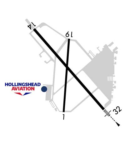 Airport Diagram might not be current. | |
| Facility Name: | SMYRNA |
| City Name: | SMYRNA |
| County: | RUTHERFORD |
| State abbrev: | TN |
| State Name: | TENNESSEE |
| Ownership: | PUBLICLY OWNED |
| Use: | OPEN TO THE PUBLIC |
| Owner's Name: | SMYRNA/RUTHERFORD ARPT AUTH |
| Address: | 278 DOUG WARPOOLE RD. |
| SMYRNA, TN 37167 | |
| Owner's Phone: | 615-459-2651 |
| Manager's Name: | EVAN LESTER |
| Address: | 278 DOUG WARPOOLE RD. |
| SMYRNA, TN 37167 | |
| Phone: | 615-459-2651 |
| FAA Region: | SOUTHERN |
| FAA Field Office: | MEM |
| Date | Sunrise | Sunset |
|---|---|---|
| 08/21/25 Thursday | 6:09 | 19:29 |
| 08/22/25 Friday | 6:10 | 19:28 |
| 08/23/25 Saturday | 6:11 | 19:26 |
| 08/24/25 Sunday | 6:11 | 19:25 |
| 08/25/25 Monday | 6:12 | 19:24 |
| 08/26/25 Tuesday | 6:13 | 19:22 |
| 08/27/25 Wednesday | 6:14 | 19:21 |
| 08/28/25 Thursday | 6:14 | 19:20 |
| 08/29/25 Friday | 6:15 | 19:18 |
| 08/30/25 Saturday | 6:16 | 19:17 |
| 08/31/25 Sunday | 6:17 | 19:15 |
| 09/01/25 Monday | 6:18 | 19:14 |
| 09/02/25 Tuesday | 6:18 | 19:13 |
| 09/03/25 Wednesday | 6:19 | 19:11 |
| Airport Attendance Schedule | CONTINUOUS |
| Airport Status | OPERATIONAL (This Status can change at any time - please check NOTAMS) |
| Airport Lighting Schedule | ACTVT MALSR RWY 32; REIL RWY 14; MIRL RWY 01/19; HIRL RWY 14/32 - CTAF. PAPI RWY 01, 14, 19 & 32 OPR CONSLY. |
| Airport Storage Available | Tie Downs, Hanger |
| Extra Services Available | Air Ambulance, Avionics, Charter, Flight Instruction, Aircraft Rental, Aircraft Sales |
| Wind Indicator | YES - (lighted) |
| Control Tower | YES |
| CTAF Frequency | 118.500 |
| Unicom Frequency | 122.950 |
| Rotating Beacon Color | WG |
| Segmented Circle | YES |
| Landing Fee | NO |
| Airport Inspected | FEDERAL - performed by FAA AIRPORTS FIELD PERSONNEL |
| Inspection Date | 03/07/2025 |
| Type of Fuel Available | Grade 100LL, JET A (freeze point -40C); -A C615-220-2957 OR C615-459-3337. |
| Airframe Repair Service | MAJOR |
| Power Plant Repair Service | MAJOR |
| Latitude | N3600.5 |
| Longitude | W08631.2 (ESTIMATED) |
| Arpt Elevation | 543ft (SURVEYED) |
| Magnetic Variation | 02W |
| 2 miles N | of SMYRNA |
| Traffic Pattern Altitude | 957; TPA: 457 FT AGL HEL, 957 FT AGL LIGHT ACFT, 1457 FT AGL TURBOPROP/JET. |
| Sectional Chart | ATLANTA |
| Operations (Reported) | Yearly | Avg. Daily |
|---|---|---|
| General Aviation Transient | 0 | 0 |
| General Aviation Local | 0 | 0 |
| Air Taxi | 0 | 0 |
| Commerical | 0 | 0 |
| Commuter | 0 | 0 |
| Military | 0 | 0 |
| Aircraft based on Field | |
|---|---|
| General Aviation Singles | 0 |
| General Aviation Multi | 0 |
| Jet Aircraft | 0 |
| General Aviation Helicopters | 0 |
| Military Aircraft | 0 |
| Gliders | 0 |
| Ultralights | 0 |
| FSS on field | NO |
| FSS tie-in | NASHVILLE |
| FSS Phone | 1-800-WX-BRIEF |
| Who issues Notams | MQY |
| Notam D service at airport | YES |
| ARTCC Name | MEMPHIS |
| Airport Certification | |
| Aircraft Rescue & Firefighting Index | AIRPORT HAS A CERTIFICATE UNDER CFR PART 139 |
| Airport of Entry | No |
| Custom Landing Rights | No |
| Joint Civil/Military | No |
| Military Landing rights | YES |
| NATIONAL PLAN OF INTEGRATED AIRPORT SYSTEMS (NPIAS) |
| GRANT AGREEMENTS UNDER FAAP/ADAP/AIP |
| SURPLUS PROPERTY AGREEMENT UNDER PUBLIC LAW 289 |
| ASSURANCES PURSUANT TO TITLE VI, CIVIL RIGHTS ACT OF 1964 |
| NASHVILLE INTL TFC TRANSITS SMYRNA TFC AREA AT 2500 FT MSL & ABV. |
| FOR CD WHEN ATCT IS CLSD CTC BNA APCH ON 121.7, IF UNA CALL 615-695-4522. |
| ANG BASE OPS 0630-1600 MON-FRI; PPR - D683-3611. |
| 24 HR PPR OVR 30 PAX - AMGR. |
| TWY J SOUTH OF TWY A LTD TO 65000 LB. |
| TWY K LTD TO 65000 LB. |
| CLASS D SVC 1300-0400Z MON-FRI. |
| RWY 01/1 9 RWY 01/19 NOT AVBL FOR PART 121/PART 380 OPS WITH SKED PAX CARRYING OPS MORE THAN 9 PAX SEATS AND NON-SKED PAX CARRYING OPS MORE THAN 30 PAX SEATS. |
| RWY H1 CLSD INDEFLY. |
Airport Communications & Frequencies:
| |||||||||||||||||||||||||||
| Runway: 01 | Runway: 19 | ||
| Mag heading: | 6° | Mag heading: | 186° |
| Rwy Slope: | .04% Up | Rwy Slope: | -.04% Down |
| Approach: | Approach: | ||
| Pattern: | Left Traffic | Pattern: | Left Traffic |
| Markings: | NONPRECISION INSTRUMENT | Markings: | NONPRECISION INSTRUMENT |
| Marking Condition: | GOOD | Marking Condition: | GOOD |
| Arresting Dev: | Arresting Dev: | ||
| Lat & Long: | N3600.0 W08631.3 | Lat. & Long.: | N3600.9 W08631.2 |
| Elev: | 519.2 ft. MSL | Elev: | 521.4 ft. MSL |
| TCH: | 27 ft. AGL | TCH: | 32 ft. AGL |
| Visual Glide Path: | 3.00 degrees | Visual Glide Path: | 3.50 degrees |
| Displaced Threshold: | No | Displaced Threshold: | No |
| Touchdown Zone: | YES | Touchdown Zone: | YES |
| Touchdown Elev.: | 519.2 feet | Touchdown Elev.: | 521.4 feet |
| Visual Glide Slope: | 4-Light PAPI on LEFT side of Runway | Visual Glide Slope: | 4-Light PAPI on LEFT side of Runway |
| RVR Equipment: | RVR Equipment: | ||
| RVV Equipment: | NO | RVV Equipment: | NO |
| Approach Lights: | Approach Lights: | ||
| REIL: | YES | REIL: | YES |
| Centerline Lights: | NO | Centerline Lights: | NO |
| Touchdown lights: | NO | Touchdown lights: | NO |
| Runway Category: | Runway with a Non-precision Approach having visibility minimums greater than 3/4 mile | Runway Category: | Runway with a Non-precision Approach having visibility minimums greater than 3/4 mile |
| Declared Distances: | Declared Distances: | ||
| Obstructions: | TREE | Obstructions: | |
| Marked: | NOT Marked/Lighted | Marked: | |
| Clearance slope: | 21:1 | Clearance slope: | 34:1 |
| Obstruction height: | 74 feet AGL | Obstruction height: | |
| Dist. from runway: | 1800 feet | Dist. from runway: | |
| Centerline offset: | 143 right of centerline | Centerline offset: | |
| Comments: | Comments: |
| Runway: 14 | Runway: 32 | ||
| Mag heading: | 141° | Mag heading: | 321° |
| Rwy Slope: | -.32% Down | Rwy Slope: | .32% Up |
| Approach: | Approach: | ILS | |
| Pattern: | Left Traffic | Pattern: | Left Traffic |
| Markings: | PRECISION INSTRUMENT | Markings: | PRECISION INSTRUMENT |
| Marking Condition: | GOOD | Marking Condition: | GOOD |
| Arresting Dev: | Arresting Dev: | ||
| Lat & Long: | N3601.1 W08631.7 | Lat. & Long.: | N3600.1 W08630.7 |
| Elev: | 543.0 ft. MSL | Elev: | 517.3 ft. MSL |
| TCH: | 50 ft. AGL | TCH: | 57 ft. AGL |
| Visual Glide Path: | 3.00 degrees | Visual Glide Path: | 3.00 degrees |
| Displaced Threshold: | No | Displaced Threshold: | No |
| Touchdown Zone: | YES | Touchdown Zone: | YES |
| Touchdown Elev.: | 543.0 feet | Touchdown Elev.: | 517.7 feet |
| Visual Glide Slope: | 4-Light PAPI on LEFT side of Runway | Visual Glide Slope: | 4-Light PAPI on LEFT side of Runway |
| RVR Equipment: | RVR Equipment: | ||
| RVV Equipment: | NO | RVV Equipment: | NO |
| Approach Lights: | Approach Lights: | MALSR - 1,400 foot medium intensity approach lighting system with runway alignment indicator lights | |
| REIL: | YES | REIL: | YES |
| Centerline Lights: | NO | Centerline Lights: | NO |
| Touchdown lights: | NO | Touchdown lights: | NO |
| Runway Category: | Runway with a Non-precision Approach having visibility minimums greater than 3/4 mile | Runway Category: | Precision Instrument Runway |
| Declared Distances: | Declared Distances: | ||
| Obstructions: | TREE | Obstructions: | |
| Marked: | NOT Marked/Lighted | Marked: | |
| Clearance slope: | 37:1 | Clearance slope: | 50:1 |
| Obstruction height: | 35 feet AGL | Obstruction height: | |
| Dist. from runway: | 1500 feet | Dist. from runway: | |
| Centerline offset: | 485 right of centerline | Centerline offset: | |
| Comments: | Comments: |
Thanks for using FltPlan.com
all rights reserved © 1999-2025 by Flight Plan LLC


