
| DARE COUNTY RGNL MANTEO NC |
| |
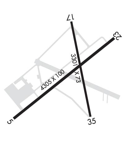
| Lat: N 3555.1 Long: W 07541.7 Elev: 13 Var: +09 Longest Runway: 4305 | ||
| AWOS: 128.27 CTAF: 122.8 | ||
| ||||||||||||||||||||||||||||||||||||||||||||
| ||||||||||||||||||||||||||||||||||||||||||||
| ||||||||||||||||||||||||||||||||||||||||||||
| ||||||||||||||||||||||||||||||||||||||||||||
| Rwy | Rwy | |||||||
| 4305x100 | 4000' | 4305x100 | 4004' | |||||
| 3301x73 | 3012' | 3301x73 | 2312' | |||||
| Runway ID | Single Wheel | Double Wheel | Double Tandem Wheel | Dual Double Wheel |
| 05/23 | 48,000 | N/A | N/A | N/A |
| 17/35 | 20,000 | N/A | N/A | N/A |
| These numbers are Advisory and are not limits. The Airport Manager should have more accurate Weight Limits | ||||
 Airport Diagram might not be current. | |
| Facility Name: | DARE COUNTY RGNL |
| City Name: | MANTEO |
| County: | DARE |
| State abbrev: | NC |
| State Name: | NORTH CAROLINA |
| Ownership: | PUBLICLY OWNED |
| Use: | OPEN TO THE PUBLIC |
| Owner's Name: | DARE COUNTY |
| Address: | PO BOX 429 |
| MANTEO, NC 27954 | |
| Owner's Phone: | 252-475-5570 |
| Manager's Name: | DAVID DANIELS |
| Address: | 410 AIRPORT ROAD |
| MANTEO, NC 27954-9110 | |
| Phone: | 252-475-5571 |
| FAA Region: | SOUTHERN |
| FAA Field Office: | MEM |

| Date | Sunrise | Sunset |
|---|---|---|
| 09/24/21 Friday | 6:52 | 18:57 |
| 09/25/21 Saturday | 6:53 | 18:56 |
| 09/26/21 Sunday | 6:54 | 18:54 |
| 09/27/21 Monday | 6:54 | 18:53 |
| 09/28/21 Tuesday | 6:55 | 18:51 |
| 09/29/21 Wednesday | 6:56 | 18:50 |
| 09/30/21 Thursday | 6:57 | 18:48 |
| 10/01/21 Friday | 6:58 | 18:47 |
| 10/02/21 Saturday | 6:58 | 18:45 |
| 10/03/21 Sunday | 6:59 | 18:44 |
| 10/04/21 Monday | 7:00 | 18:43 |
| 10/05/21 Tuesday | 7:01 | 18:41 |
| 10/06/21 Wednesday | 7:02 | 18:40 |
| 10/07/21 Thursday | 7:02 | 18:38 |
| Airport Attendance Schedule | 7 Days A Week 0800-1900; UNATTENDED CHRISTMAS DAY. FOR SERVICE AFT HRS CALL 252-216-7028 OR 252-216-8407. |
| Airport Status | OPERATIONAL (This Status can change at any time - please check NOTAMS) |
| Airport Lighting Schedule | ACTVT MIRL RYS 05/23 & 17/35 AND REIL RY 05 - CTAF. PAPI RYS 05 & 23 OPERATES CONTINUOUSLY. |
| Airport Storage Available | Tie Downs, Hanger |
| Extra Services Available | Air Freight, Air Ambulance, Charter, Flight Instruction, Parachute Jumping, Aircraft Rental |
| Wind Indicator | YES - (lighted) |
| Control Tower | NO |
| CTAF Frequency | 122.800 |
| Unicom Frequency | 122.800 |
| Rotating Beacon Color | CLEAR-GREEN (Light Land Airport) |
| Segmented Circle | YES |
| Landing Fee | NO |
| Airport Inspected | STATE - performed by STATE AERONAUTICAL PERSONNEL |
| Inspection Date | 03/28/2020 |
| Type of Fuel Available | Grade 100LL, JET A-1 (icing inhibitor, freeze point -50C); -10100LL AVBL AFT HRS SELF SERVICE WITH CREDIT CARD. |
| Airframe Repair Service | MAJOR |
| Power Plant Repair Service | MAJOR |
| Latitude | N3555.1 |
| Longitude | W07541.7 (ESTIMATED) |
| Arpt Elevation | 13ft (SURVEYED) |
| Magnetic Variation | 09W |
| 1 miles NW | of MANTEO |
| Traffic Pattern Altitude | |
| Sectional Chart | CHARLOTTE |
| Operations (Reported) | Yearly | Avg. Daily |
|---|---|---|
| General Aviation Transient | 4400 | 12 |
| General Aviation Local | 2300 | 6 |
| Air Taxi | 10050 | 28 |
| Commerical | 0 | 0 |
| Commuter | 0 | 0 |
| Military | 200 | 1 |
| Aircraft based on Field | |
|---|---|
| General Aviation Singles | 41 |
| General Aviation Multi | 2 |
| Jet Aircraft | 0 |
| General Aviation Helicopters | 2 |
| Military Aircraft | 0 |
| Gliders | 0 |
| Ultralights | 0 |
| FSS on field | NO |
| FSS tie-in | RALEIGH |
| FSS Phone | 1-800-WX-BRIEF |
| Who issues Notams | MQI |
| Notam D service at airport | YES |
| ARTCC Name | WASHINGTON |
| Airport Certification | |
| Aircraft Rescue & Firefighting Index | None |
| Airport of Entry | No |
| Custom Landing Rights | No |
| Joint Civil/Military | No |
| Military Landing rights | YES |
| NATIONAL PLAN OF INTEGRATED AIRPORT SYSTEMS (NPIAS) |
| GRANT AGREEMENTS UNDER FAAP/ADAP/AIP |
| SURPLUS PROPERTY AGREEMENT UNDER PUBLIC LAW 289 |
| SURPLUS PROPERTY AGREEMENT UNDER REGULATION 16-WAA |
| ASSURANCES PURSUANT TO TITLE VI, CIVIL RIGHTS ACT OF 1964 |
| AGREEMENT UNDER DLAND OR DCLA HAS EXPIRED. |
| RY 05 15 FT DROPOFF 40 FT FM THLD 0B. |
| TWY F CLSD PERMLY. |
| FOR CD CTC CHERRY POINT APCH AT 252-466-5960, OR WHEN APCH CLSD CTC WASHINGTON ARTCC AT 703-771-3587. |
| MIGRATORY WATERFOWL OCT - FEB. |
| BANNER TOWING OPNS 200 FT W OF RY 05. |
| SEAPLANE RAMP NEAR APRON. |
| FBO CLSD CHRISTMAS DAY. |
Airport Communications & Frequencies:
| ||||||||||||||
| Runway: 05 | Runway: 23 | ||
| Mag heading: | 47° | Mag heading: | 227° |
| Rwy Slope: | .07% Up | Rwy Slope: | -.07% Down |
| Approach: | Approach: | ||
| Pattern: | Left Traffic | Pattern: | Left Traffic |
| Markings: | NONPRECISION INSTRUMENT | Markings: | NONPRECISION INSTRUMENT |
| Marking Condition: | GOOD | Marking Condition: | GOOD |
| Arresting Dev: | Arresting Dev: | ||
| Lat & Long: | N3554.8 W07542.0 | Lat. & Long.: | N3555.4 W07541.5 |
| Elev: | 9.0 ft. MSL | Elev: | 12.1 ft. MSL |
| TCH: | 28 ft. AGL | TCH: | 31 ft. AGL |
| Visual Glide Path: | 3.00 degrees | Visual Glide Path: | 4.00 degrees |
| Displaced Threshold: | 305 feet | Displaced Threshold: | 301 feet |
| Touchdown Zone: | YES | Touchdown Zone: | YES |
| Touchdown Elev.: | 12.4 feet | Touchdown Elev.: | 12.4 feet |
| Visual Glide Slope: | 2-Light PAPI on LEFT side of Runway | Visual Glide Slope: | 2-Light PAPI on LEFT side of Runway |
| RVR Equipment: | RVR Equipment: | ||
| RVV Equipment: | NO | RVV Equipment: | NO |
| Approach Lights: | Approach Lights: | ||
| REIL: | YES | REIL: | NO |
| Centerline Lights: | NO | Centerline Lights: | NO |
| Touchdown lights: | NO | Touchdown lights: | NO |
| Runway Category: | Runway with a Non-precision Approach having visibility minimums greater than 3/4 mile | Runway Category: | Runway with a Non-precision Approach having visibility minimums greater than 3/4 mile |
| Declared Distances: | Declared Distances: | ||
| Obstructions: | Obstructions: | BLDG | |
| Marked: | Marked: | NOT Marked/Lighted | |
| Clearance slope: | 50:1 | Clearance slope: | 3:1; APCH SLOPE 11:1 AT DSPLCD THLD DUE TO 15 FT ROAD 378 FT FM DSPLCD THLD AND BOTH SIDES OF CNTRLN. |
| Obstruction height: | Obstruction height: | 27 feet AGL | |
| Dist. from runway: | Dist. from runway: | 304 feet | |
| Centerline offset: | Centerline offset: | 258 feet left of centerline | |
| Comments: | Comments: | 7 FT FENCE 100-300 FT FM END OF PAVEMENT BOTH SIDES OF CNTRLN; 15 FT ROAD 130 FT FM END OF PAVEMENT AND BOTH SIDES OF CNTRLN; 12 FT BRUSH 28 FT FM END OF PAVEMENT OFFSET 117 FT LEFT OF CNTRLN; 24 FT TREE 115 FT FM END OF PAVEMENT OFFSET 233 FT LEFT OF CNTRLN. |
| Runway: 17 | Runway: 35 | ||
| Mag heading: | 167° | Mag heading: | 347° |
| Rwy Slope: | -.09% Down | Rwy Slope: | .09% Up |
| Approach: | Approach: | ||
| Pattern: | Left Traffic | Pattern: | Left Traffic |
| Markings: | NONPRECISION INSTRUMENT | Markings: | NONPRECISION INSTRUMENT |
| Marking Condition: | GOOD | Marking Condition: | GOOD |
| Arresting Dev: | Arresting Dev: | ||
| Lat & Long: | N3555.4 W07541.8 | Lat. & Long.: | N3554.9 W07541.5 |
| Elev: | 12.5 ft. MSL | Elev: | 9.5 ft. MSL |
| TCH: | TCH: | ||
| Visual Glide Path: | Visual Glide Path: | ||
| Displaced Threshold: | 289 feet | Displaced Threshold: | 989 feet |
| Touchdown Zone: | YES | Touchdown Zone: | YES |
| Touchdown Elev.: | 12.8 feet | Touchdown Elev.: | 13.0 feet |
| Visual Glide Slope: | Visual Glide Slope: | ||
| RVR Equipment: | RVR Equipment: | ||
| RVV Equipment: | NO | RVV Equipment: | NO |
| Approach Lights: | Approach Lights: | ||
| REIL: | NO | REIL: | NO |
| Centerline Lights: | NO | Centerline Lights: | NO |
| Touchdown lights: | NO | Touchdown lights: | NO |
| Runway Category: | Runway with a Non-precision Approach having visibility minimums greater than 3/4 mile | Runway Category: | Runway with a Visual Approach |
| Declared Distances: | Declared Distances: | ||
| Obstructions: | TREES | Obstructions: | TREES |
| Marked: | NOT Marked/Lighted | Marked: | NOT Marked/Lighted |
| Clearance slope: | 9:1; APCH SLOPE 12:1 AT DSPLCD . | Clearance slope: | 4:1; APCH SLOPE 15:1 AT DSPLCD THLD DUE TO 90 FT TREES 1612 FT FM DSPLCD THLD OFFSET 224 FT RIGHT OF CNTRLN. |
| Obstruction height: | 95 feet AGL | Obstruction height: | 84 feet AGL |
| Dist. from runway: | 1120 feet | Dist. from runway: | 606 feet |
| Centerline offset: | 252 right of centerline | Centerline offset: | 241 feet right of centerline |
| Comments: | Comments: | 10 FT BRUSH 133 FT FM END OF PAVEMENT OFFSET 21 FT RIGHT OF CNTRLN. |
Thanks for using FltPlan.com
all rights reserved © 1999-2021 by Flight Plan LLC