
| DELAWARE COUNTY RGNL MUNCIE IN |
| |
| Lat: N 4014.5 Long: W 08523.7 Elev: 937 Var: +03 Longest Runway: 6500 | ||
| Dept. ATIS: 133.25 Arr. ATIS: 133.25 AWOS: 114.4 Ground: 121.9 Tower: 120.1 | ||
| ||||||||||||||||||||||||||||||||||||||||||||
| ||||||||||||||||||||||||||||||||||||||||||||
| ||||||||||||||||||||||||||||||||||||||||||||
| FBOs at nearby airports who want your business: | |||||||||||||||||
| |||||||||||||||||
| Rwy | Rwy | |||||||
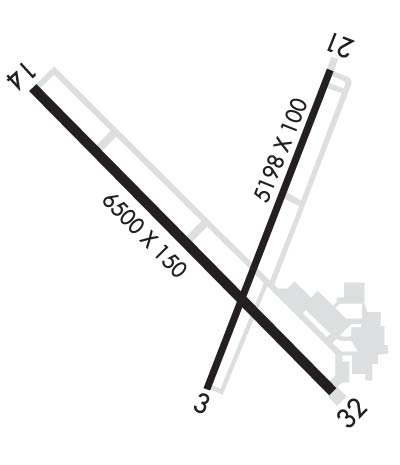
| 5198x100 | 5198' | 5198x100 | 5198' | |||||
| 6500x150 | 6500' | 6500x150 | 6500' | 109.10 - 319° | ||||
| Runway ID | Single Wheel | Double Wheel | Double Tandem Wheel | Dual Double Wheel |
| 03/21 | 80,000 | 100,000 | 125,000 | N/A |
| 14/32 | 91,000 | 125,000 | 215,000 | N/A |
| These numbers are Advisory and are not limits. The Airport Manager should have more accurate Weight Limits | ||||
 Airport Diagram might not be current. | |
| Facility Name: | DELAWARE COUNTY RGNL |
| City Name: | MUNCIE |
| County: | DELAWARE |
| State abbrev: | IN |
| State Name: | INDIANA |
| Ownership: | PUBLICLY OWNED |
| Use: | OPEN TO THE PUBLIC |
| Owner's Name: | DELAWARE COUNTY ARPT AUTH |
| Address: | 311 W. CARL SIMMONS RD. |
| MUNCIE, IN 47303 | |
| Owner's Phone: | 765-747-5690 |
| Manager's Name: | TIM BATY |
| Address: | 311 W. CARL SIMMONS RD. |
| MUNCIE, IN 47303 | |
| Phone: | 765-747-5690; 765-729-1078 |
| FAA Region: | GREAT LAKES |
| FAA Field Office: | CHI |
| Date | Sunrise | Sunset |
|---|---|---|
| 09/24/21 Friday | 7:31 | 19:36 |
| 09/25/21 Saturday | 7:32 | 19:34 |
| 09/26/21 Sunday | 7:33 | 19:32 |
| 09/27/21 Monday | 7:34 | 19:31 |
| 09/28/21 Tuesday | 7:35 | 19:29 |
| 09/29/21 Wednesday | 7:36 | 19:27 |
| 09/30/21 Thursday | 7:37 | 19:26 |
| 10/01/21 Friday | 7:38 | 19:24 |
| 10/02/21 Saturday | 7:39 | 19:23 |
| 10/03/21 Sunday | 7:40 | 19:21 |
| 10/04/21 Monday | 7:41 | 19:19 |
| 10/05/21 Tuesday | 7:42 | 19:18 |
| 10/06/21 Wednesday | 7:43 | 19:16 |
| 10/07/21 Thursday | 7:44 | 19:14 |
| Airport Attendance Schedule | 7 Days A Week 0600-2200 |
| Airport Status | OPERATIONAL (This Status can change at any time - please check NOTAMS) |
| Airport Lighting Schedule | ACTVT MALSR RWY 32; REIL RWY 3, 14 & 21; PAPI RWY 14 & 21; MIRL RWY 3/21; HIRL RWY 14/32 - CTAF. REIL RWY 3, 14 & 21 HIGH INTSTY ONLY. PAPI RWY 3 ON CONSLY. |
| Airport Storage Available | Tie Downs, Hanger |
| Extra Services Available | Air Freight, Avionics, Charter, Flight Instruction, Aircraft Rental, Aircraft Sales |
| Wind Indicator | YES - (lighted) |
| Control Tower | YES |
| CTAF Frequency | 120.100 |
| Unicom Frequency | 122.950 |
| Rotating Beacon Color | CLEAR-GREEN (Light Land Airport) |
| Segmented Circle | YES |
| Landing Fee |
| Airport Inspected | FEDERAL - performed by FAA AIRPORTS FIELD PERSONNEL |
| Inspection Date | 04/07/2017 |
| Type of Fuel Available | Grade 100LL, JET A (freeze point -40C) |
| Airframe Repair Service | MINOR |
| Power Plant Repair Service | MINOR |
| Latitude | N4014.5 |
| Longitude | W08523.7 (ESTIMATED) |
| Arpt Elevation | 937ft (SURVEYED) |
| Magnetic Variation | 03W |
| 3 miles NW | of MUNCIE |
| Traffic Pattern Altitude | |
| Sectional Chart | CHICAGO |
| Operations (Reported) | Yearly | Avg. Daily |
|---|---|---|
| General Aviation Transient | 15789 | 43 |
| General Aviation Local | 9868 | 27 |
| Air Taxi | 1017 | 3 |
| Commerical | 15 | 0 |
| Commuter | 0 | 0 |
| Military | 411 | 1 |
| Aircraft based on Field | |
|---|---|
| General Aviation Singles | 32 |
| General Aviation Multi | 1 |
| Jet Aircraft | 2 |
| General Aviation Helicopters | 0 |
| Military Aircraft | 0 |
| Gliders | 0 |
| Ultralights | 0 |
| FSS on field | NO |
| FSS tie-in | TERRE HAUTE |
| FSS Phone | 1-800-WX-BRIEF |
| Who issues Notams | MIE |
| Notam D service at airport | YES |
| ARTCC Name | INDIANAPOLIS |
| Airport Certification | CLSD TO SKED ACR OPS GTR THAN 9 PAX SEATS & UNSKED ACR OPS GTR THAN 30 PAX SEATS 48 HR PPR - AMGR. INDEX B ARFF CAPABILITY AVBL ON REQ. |
| Aircraft Rescue & Firefighting Index | AIRPORT HAS A CERTIFICATE UNDER CFR PART 139 |
| Airport of Entry | No |
| Custom Landing Rights | No |
| Joint Civil/Military | No |
| Military Landing rights | YES |
| NATIONAL PLAN OF INTEGRATED AIRPORT SYSTEMS (NPIAS) |
| GRANT AGREEMENTS UNDER FAAP/ADAP/AIP |
| ASSURANCES PURSUANT TO TITLE VI, CIVIL RIGHTS ACT OF 1964 |
| DEER ON & INVOF ARPT. |
| SVC AFT HR - 765-729-1078. |
| WHEN ATCT IS CLSD FOR CD CTC INDIANAPOLIS APCH AT 317-227-5743. |
| RWY 03/2 1 UNSKED ACR OPS WITH AT LEAST 31 PAX SEATS NA. |
| RWY 14/3 2 CALM WIND RWY. |
Airport Communications & Frequencies:
| |||||||||||||||||||||||||||
| Runway: 03 | Runway: 21 | ||
| Mag heading: | 25° | Mag heading: | 205° |
| Rwy Slope: | -.05% Down | Rwy Slope: | .05% Up |
| Approach: | Approach: | ||
| Pattern: | Left Traffic | Pattern: | Left Traffic |
| Markings: | NONPRECISION INSTRUMENT | Markings: | NONPRECISION INSTRUMENT |
| Marking Condition: | GOOD | Marking Condition: | GOOD |
| Arresting Dev: | Arresting Dev: | ||
| Lat & Long: | N4014.2 W08523.8 | Lat. & Long.: | N4015.0 W08523.4 |
| Elev: | 937.3 ft. MSL | Elev: | 934.7 ft. MSL |
| TCH: | 39 ft. AGL | TCH: | 45 ft. AGL |
| Visual Glide Path: | 3.00 degrees | Visual Glide Path: | 3.00 degrees |
| Displaced Threshold: | No | Displaced Threshold: | No |
| Touchdown Zone: | YES | Touchdown Zone: | YES |
| Touchdown Elev.: | 937.3 feet | Touchdown Elev.: | 935.0 feet |
| Visual Glide Slope: | 4-Light PAPI on LEFT side of Runway | Visual Glide Slope: | 4-Light PAPI on LEFT side of Runway |
| RVR Equipment: | RVR Equipment: | ||
| RVV Equipment: | NO | RVV Equipment: | NO |
| Approach Lights: | Approach Lights: | ||
| REIL: | YES | REIL: | YES |
| Centerline Lights: | NO | Centerline Lights: | NO |
| Touchdown lights: | NO | Touchdown lights: | NO |
| Runway Category: | Runway with a Visual Approach | Runway Category: | Runway with a Non-precision Approach having visibility minimums greater than 3/4 mile |
| Declared Distances: | TORA:5197' TODA:5197' ASDA:5197' LDA:5197' | Declared Distances: | TORA:5197' TODA:5197' ASDA:5197' LDA:5197' |
| Obstructions: | TREE | Obstructions: | TREE |
| Marked: | NOT Marked/Lighted | Marked: | NOT Marked/Lighted |
| Clearance slope: | 23:1 | Clearance slope: | 25:1 |
| Obstruction height: | 58 feet AGL | Obstruction height: | 44 feet AGL |
| Dist. from runway: | 1570 feet | Dist. from runway: | 1281 feet |
| Centerline offset: | 241 left of centerline | Centerline offset: | 424 feet left of centerline |
| Comments: | Comments: |
| Runway: 14 | Runway: 32 | ||
| Mag heading: | 139° | Mag heading: | 319° |
| Rwy Slope: | .12% Up | Rwy Slope: | -.12% Down |
| Approach: | Approach: | ILS | |
| Pattern: | Left Traffic | Pattern: | Left Traffic |
| Markings: | PRECISION INSTRUMENT | Markings: | PRECISION INSTRUMENT |
| Marking Condition: | FAIR | Marking Condition: | GOOD |
| Arresting Dev: | Arresting Dev: | ||
| Lat & Long: | N4014.9 W08524.4 | Lat. & Long.: | N4014.2 W08523.4 |
| Elev: | 928.6 ft. MSL | Elev: | 936.4 ft. MSL |
| TCH: | 49 ft. AGL | TCH: | |
| Visual Glide Path: | 3.00 degrees | Visual Glide Path: | |
| Displaced Threshold: | No | Displaced Threshold: | No |
| Touchdown Zone: | YES | Touchdown Zone: | YES |
| Touchdown Elev.: | 933.4 feet | Touchdown Elev.: | 936.5 feet |
| Visual Glide Slope: | 4-Light PAPI on LEFT side of Runway | Visual Glide Slope: | |
| RVR Equipment: | RVR Equipment: | ||
| RVV Equipment: | NO | RVV Equipment: | NO |
| Approach Lights: | Approach Lights: | MALSR - 1,400 foot medium intensity approach lighting system with runway alignment indicator lights | |
| REIL: | YES | REIL: | NO |
| Centerline Lights: | NO | Centerline Lights: | NO |
| Touchdown lights: | NO | Touchdown lights: | NO |
| Runway Category: | Runway with a Non-precision Approach having visibility minimums greater than 3/4 mile | Runway Category: | Precision Instrument Runway |
| Declared Distances: | TORA:6500' TODA:6500' ASDA:6500' LDA:6500' | Declared Distances: | TORA:6500' TODA:6500' ASDA:6500' LDA:6500' |
| Obstructions: | TREES | Obstructions: | TREES |
| Marked: | NOT Marked/Lighted | Marked: | NOT Marked/Lighted |
| Clearance slope: | 40:1 | Clearance slope: | 39:1 |
| Obstruction height: | 98 feet AGL | Obstruction height: | 73 feet AGL |
| Dist. from runway: | 4200 feet | Dist. from runway: | 3066 feet |
| Centerline offset: | 50 right of centerline | Centerline offset: | 857 feet left of centerline |
| Comments: | Comments: |
Thanks for using FltPlan.com
all rights reserved © 1999-2021 by Flight Plan LLC