
| CRYSTAL MINNEAPOLIS MN |
| |
| Lat: N 4503.7 Long: W 09321.2 Elev: 869 Var: -02 Longest Runway: 3751 | ||
| Clr Del: 121.6 Dept. ATIS: 124.47 Arr. ATIS: 124.47 Ground: 121.6 Tower: 120.7 | ||
| |||||||||||||||||||||||||||||||||||||||||||||||||||||||||||||
| |||||||||||||||||||||||||||||||||||||||||||||||||||||||||||||
| |||||||||||||||||||||||||||||||||||||||||||||||||||||||||||||
| |||||||||||||||||||||||||||||||||||||||||||||||||||||||||||||
| |||||||||||||||||||||||||||||||||||||||||||||||||||||||||||||
| Rwy | Rwy | |||||||
| 2500x75 | 2110' | 2500x75 | 2111' | |||||
| 1669x137 | 1669' | 1669x137 | 1669' | |||||
| 3751x75 | 3510' | 3751x75 | 3510' | |||||
| Runway ID | Single Wheel | Double Wheel | Double Tandem Wheel | Dual Double Wheel |
| 06L/24R | 12,500 | N/A | N/A | N/A |
| 06R/24L | N/A | N/A | N/A | N/A |
| 14/32 | 13,000 | 25,000 | N/A | N/A |
| These numbers are Advisory and are not limits. The Airport Manager should have more accurate Weight Limits | ||||
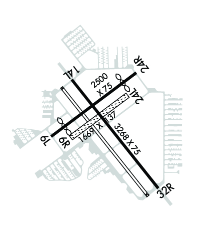 Airport Diagram might not be current. | |
| Facility Name: | CRYSTAL |
| City Name: | MINNEAPOLIS |
| County: | HENNEPIN |
| State abbrev: | MN |
| State Name: | MINNESOTA |
| Ownership: | PUBLICLY OWNED |
| Use: | OPEN TO THE PUBLIC |
| Owner's Name: | METROPOLITAN AIRPORT CMSN |
| Address: | 6040 28TH AVE S |
| MINNEAPOLIS, MN 55450-2799 | |
| Owner's Phone: | 612-726-8100 |
| Manager's Name: | MIKE WILSON; MIKE.WILSON@MSPMAC.ORG. |
| Address: | 5800 CRYSTAL AIRPORT RD |
| MINNEAPOLIS, MN 55429-2364 | |
| Phone: | 651-224-4306 |
| FAA Region: | GREAT LAKES |
| FAA Field Office: | DMA |
| Date | Sunrise | Sunset |
|---|---|---|
| 09/24/21 Friday | 7:03 | 19:08 |
| 09/25/21 Saturday | 7:04 | 19:06 |
| 09/26/21 Sunday | 7:05 | 19:04 |
| 09/27/21 Monday | 7:06 | 19:02 |
| 09/28/21 Tuesday | 7:07 | 19:00 |
| 09/29/21 Wednesday | 7:09 | 18:58 |
| 09/30/21 Thursday | 7:10 | 18:56 |
| 10/01/21 Friday | 7:11 | 18:54 |
| 10/02/21 Saturday | 7:12 | 18:52 |
| 10/03/21 Sunday | 7:14 | 18:50 |
| 10/04/21 Monday | 7:15 | 18:49 |
| 10/05/21 Tuesday | 7:16 | 18:47 |
| 10/06/21 Wednesday | 7:17 | 18:45 |
| 10/07/21 Thursday | 7:19 | 18:43 |
| Airport Attendance Schedule | 7 Days A Week 0700-2100 |
| Airport Status | OPERATIONAL (This Status can change at any time - please check NOTAMS) |
| Airport Lighting Schedule | WHEN ATCT CLSD ACTVT REIL RWY 14 & 32; PAPI RWY 14 & 32; MIRL RWY 14/32 & 06L/24R - CTAF. |
| Airport Storage Available | Tie Downs, Hanger |
| Extra Services Available | Air Ambulance, Charter, Flight Instruction, Aircraft Rental, Aircraft Sales |
| Wind Indicator | YES - (lighted) |
| Control Tower | YES |
| CTAF Frequency | 120.700 |
| Unicom Frequency | 122.950 |
| Rotating Beacon Color | CLEAR-GREEN (Light Land Airport) |
| Segmented Circle | NO |
| Landing Fee | NO |
| Airport Inspected | STATE - performed by STATE AERONAUTICAL PERSONNEL |
| Inspection Date | 11/05/2020 |
| Type of Fuel Available | Grade 100LL, JET A (freeze point -40C); -10FUEL AVBL H24 VIA CREDIT CARD. |
| Airframe Repair Service | MAJOR |
| Power Plant Repair Service | MAJOR |
| Latitude | N4503.7 |
| Longitude | W09321.2 (ESTIMATED) |
| Arpt Elevation | 869ft (SURVEYED) |
| Magnetic Variation | 02E |
| 8 miles NW | of MINNEAPOLIS |
| Traffic Pattern Altitude | |
| Sectional Chart | TWIN CITIES |
| Operations (Reported) | Yearly | Avg. Daily |
|---|---|---|
| General Aviation Transient | 22458 | 62 |
| General Aviation Local | 19250 | 53 |
| Air Taxi | 549 | 2 |
| Commerical | 0 | 0 |
| Commuter | 0 | 0 |
| Military | 94 | 0 |
| Aircraft based on Field | |
|---|---|
| General Aviation Singles | 123 |
| General Aviation Multi | 4 |
| Jet Aircraft | 0 |
| General Aviation Helicopters | 3 |
| Military Aircraft | 0 |
| Gliders | 0 |
| Ultralights | 0 |
| FSS on field | NO |
| FSS tie-in | PRINCETON |
| FSS Phone | 1-800-WX-BRIEF |
| Who issues Notams | MIC |
| Notam D service at airport | YES |
| ARTCC Name | MINNEAPOLIS |
| Airport Certification | |
| Aircraft Rescue & Firefighting Index | None |
| Airport of Entry | No |
| Custom Landing Rights | No |
| Joint Civil/Military | No |
| Military Landing rights | YES |
| NATIONAL PLAN OF INTEGRATED AIRPORT SYSTEMS (NPIAS) |
| GRANT AGREEMENTS UNDER FAAP/ADAP/AIP |
| ASSURANCES PURSUANT TO TITLE VI, CIVIL RIGHTS ACT OF 1964 |
| BIRDS & WILDLIFE ON & INVOF ARPT. |
| ULTRALIGHT OPS PROHIBITED. |
| WHEN ATCT CLSD SNOW REMOVAL OPS MNT CTAF. |
| VOLUNTARY NOISE ABATEMENT PROCS IN EFCT SEE WWW.MACNOISE.COM/PILOTS. |
| HEL TRG CONDUCTED OVR GRASS EAST OF RWY 32 & SOUTH OF RWY 24L. |
| RWY 06R/ 24LCLSD NOV-APR; CLSD WHEN ATCT CLSD. |
| RWY 14 CALM WIND RWY WHEN ATCT CLSD. |
Airport Communications & Frequencies:
| |||||||||||||||||||||||||||
| Runway: 06L | Runway: 24R | ||
| Mag heading: | 51° | Mag heading: | 231° |
| Rwy Slope: | -.08% Down | Rwy Slope: | .08% Up |
| Approach: | Approach: | ||
| Pattern: | Left Traffic | Pattern: | Left Traffic |
| Markings: | BASIC | Markings: | BASIC |
| Marking Condition: | GOOD | Marking Condition: | GOOD |
| Arresting Dev: | Arresting Dev: | ||
| Lat & Long: | N4503.7 W09321.5 | Lat. & Long.: | N4503.9 W09321.1 |
| Elev: | 869.2 ft. MSL | Elev: | 867.1 ft. MSL |
| TCH: | 27 ft. AGL | TCH: | 29 ft. AGL |
| Visual Glide Path: | 4.00 degrees | Visual Glide Path: | 3.50 degrees |
| Displaced Threshold: | 390 feet | Displaced Threshold: | 389 feet |
| Touchdown Zone: | YES | Touchdown Zone: | YES |
| Touchdown Elev.: | 869.3 feet | Touchdown Elev.: | 869.3 feet |
| Visual Glide Slope: | 4-BOX VASI ON LEFT SIDE OF RUNWAY | Visual Glide Slope: | 4-BOX VASI ON LEFT SIDE OF RUNWAY |
| RVR Equipment: | RVR Equipment: | ||
| RVV Equipment: | NO | RVV Equipment: | NO |
| Approach Lights: | Approach Lights: | ||
| REIL: | NO | REIL: | NO |
| Centerline Lights: | NO | Centerline Lights: | NO |
| Touchdown lights: | NO | Touchdown lights: | NO |
| Runway Category: | Runway with a Visual Approach | Runway Category: | Runway with a Visual Approach |
| Declared Distances: | TORA:2500' TODA:2500' ASDA:2500' LDA:2110' | Declared Distances: | TORA:2500' TODA:2500' ASDA:2500' LDA:2111' |
| Obstructions: | TREE | Obstructions: | TREE |
| Marked: | NOT Marked/Lighted | Marked: | NOT Marked/Lighted |
| Clearance slope: | 14:1; 23:1 TO DTHR. | Clearance slope: | 12:1; 21:1 TO DTHR. |
| Obstruction height: | 67 feet AGL | Obstruction height: | 65 feet AGL |
| Dist. from runway: | 1160 feet | Dist. from runway: | 995 feet |
| Centerline offset: | 198 right of centerline | Centerline offset: | 2 feet right of centerline |
| Comments: | Comments: |
| Runway: 06R | Runway: 24L | ||
| Mag heading: | 51° | Mag heading: | 231° |
| Rwy Slope: | -.12% Down | Rwy Slope: | .12% Up |
| Approach: | Approach: | ||
| Pattern: | Left Traffic | Pattern: | Left Traffic |
| Markings: | Markings: | ||
| Marking Condition: | GOOD; YELLOW CONES. | Marking Condition: | GOOD; YELLOW CONES. |
| Arresting Dev: | Arresting Dev: | ||
| Lat & Long: | N4503.7 W09321.4 | Lat. & Long.: | N4503.8 W09321.1 |
| Elev: | 869.0 ft. MSL | Elev: | 867.0 ft. MSL |
| TCH: | TCH: | ||
| Visual Glide Path: | Visual Glide Path: | ||
| Displaced Threshold: | No | Displaced Threshold: | No |
| Touchdown Zone: | YES | Touchdown Zone: | YES |
| Touchdown Elev.: | 869.0 feet | Touchdown Elev.: | 869.0 feet |
| Visual Glide Slope: | Visual Glide Slope: | ||
| RVR Equipment: | RVR Equipment: | ||
| RVV Equipment: | NO | RVV Equipment: | NO |
| Approach Lights: | Approach Lights: | ||
| REIL: | NO | REIL: | NO |
| Centerline Lights: | NO | Centerline Lights: | NO |
| Touchdown lights: | NO | Touchdown lights: | NO |
| Runway Category: | Runway with a Visual Approach | Runway Category: | Runway with a Visual Approach |
| Declared Distances: | Declared Distances: |
| Runway: 14 | Runway: 32 | ||
| Mag heading: | 139° | Mag heading: | 319° |
| Rwy Slope: | -.03% Down | Rwy Slope: | .03% Up |
| Approach: | Approach: | ||
| Pattern: | Left Traffic | Pattern: | Left Traffic |
| Markings: | NONPRECISION INSTRUMENT | Markings: | NONPRECISION INSTRUMENT |
| Marking Condition: | GOOD | Marking Condition: | GOOD |
| Arresting Dev: | Arresting Dev: | ||
| Lat & Long: | N4503.9 W09321.5 | Lat. & Long.: | N4503.5 W09320.9 |
| Elev: | 868.5 ft. MSL | Elev: | 867.2 ft. MSL |
| TCH: | 37 ft. AGL | TCH: | 35 ft. AGL |
| Visual Glide Path: | 4.00 degrees | Visual Glide Path: | 4.00 degrees |
| Displaced Threshold: | 241 feet | Displaced Threshold: | 241 feet |
| Touchdown Zone: | YES | Touchdown Zone: | YES |
| Touchdown Elev.: | 868.6 feet | Touchdown Elev.: | 868.6 feet |
| Visual Glide Slope: | 4-Light PAPI on LEFT side of Runway | Visual Glide Slope: | 4-Light PAPI on LEFT side of Runway |
| RVR Equipment: | RVR Equipment: | ||
| RVV Equipment: | NO | RVV Equipment: | NO |
| Approach Lights: | Approach Lights: | ||
| REIL: | YES | REIL: | YES |
| Centerline Lights: | NO | Centerline Lights: | NO |
| Touchdown lights: | NO | Touchdown lights: | NO |
| Runway Category: | Runway with a Non-precision Approach having visibility minimums greater than 3/4 mile | Runway Category: | Runway with a Visual Approach |
| Declared Distances: | TORA:3509' TODA:3509' ASDA:3750' LDA:3508' | Declared Distances: | TORA:3508' TODA:3508' ASDA:3750' LDA:3509' |
| Obstructions: | TREE | Obstructions: | TREES |
| Marked: | NOT Marked/Lighted | Marked: | NOT Marked/Lighted |
| Clearance slope: | 15:1; CLNC SLP 23:1 TO DTHR. | Clearance slope: | 16:1; CLNC SLP 25:1 TO DTHR. |
| Obstruction height: | 57 feet AGL | Obstruction height: | 46 feet AGL |
| Dist. from runway: | 1103 feet | Dist. from runway: | 947 feet |
| Centerline offset: | 2 left of centerline | Centerline offset: | 297 feet right of centerline |
| Comments: | Comments: |
Thanks for using FltPlan.com
all rights reserved © 1999-2021 by Flight Plan LLC

