
| MANHATTAN RGNL MANHATTAN KS |
| |
| Lat: N 3908.5 Long: W 09640.3 Elev: 1066 Var: -04 Longest Runway: 7000 | ||
| AWOS: 119.07 Ground: 121.85 Tower: 118.55 | ||
| ||||||||||||||||||||||||||||||||||||||||||||
| ||||||||||||||||||||||||||||||||||||||||||||
| ||||||||||||||||||||||||||||||||||||||||||||
| ||||||||||||||||||||||||||||||||||||||||||||
| Rwy | Rwy | |||||||
| 7000x150 | 7000' | 111.30 - 035° | 7000x150 | 7000' | ||||
| 5001x75 | 5001' | 5001x75 | 5001' | |||||
| Runway ID | Single Wheel | Double Wheel | Double Tandem Wheel | Dual Double Wheel |
| 03/21 | 75,000 | 110,000 | N/A | N/A |
| 13/31 | 30,000 | 39,000 | N/A | N/A |
| These numbers are Advisory and are not limits. The Airport Manager should have more accurate Weight Limits | ||||
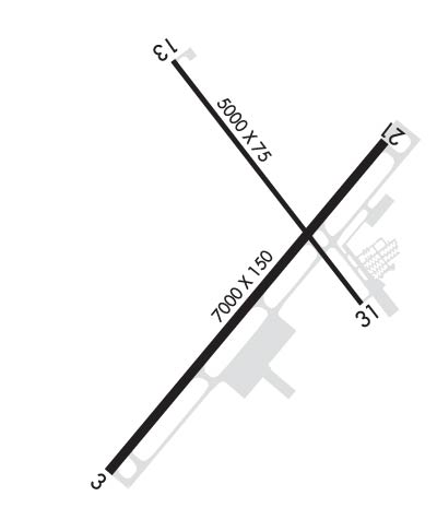 Airport Diagram might not be current. | |
| Facility Name: | MANHATTAN RGNL |
| City Name: | MANHATTAN |
| County: | RILEY |
| State abbrev: | KS |
| State Name: | KANSAS |
| Ownership: | PUBLICLY OWNED |
| Use: | OPEN TO THE PUBLIC; AFT HRS ACR OPS ARE NOT AUTH IN EXCESS OF 15 MINS BFR OR AFT SKED ARR OR DEP TIME WO PRIOR COORDN TO CFM ARFF SERS ARE AVBL PRIOR TO LDG OR TKOF. CTC MHK ARFF 785-587-4521. |
| Owner's Name: | CITY OF MANHATTAN |
| Address: | 1101 POYNTZ |
| MANHATTAN, KS 66502-5497 | |
| Owner's Phone: | 785-587-4560 |
| Manager's Name: | JESSE R. ROMO |
| Address: | 5500 SKYWAY DRIVE, STE 120 |
| MANHATTAN, KS 66503-9791 | |
| Phone: | 785-587-4565; AFT HRS (2200-0600 CST) CONTACT 785-587-4562. |
| FAA Region: | CENTRAL |
| FAA Field Office: | NONE |
| Date | Sunrise | Sunset |
|---|---|---|
| 09/24/21 Friday | 7:16 | 19:21 |
| 09/25/21 Saturday | 7:17 | 19:19 |
| 09/26/21 Sunday | 7:18 | 19:18 |
| 09/27/21 Monday | 7:19 | 19:16 |
| 09/28/21 Tuesday | 7:20 | 19:14 |
| 09/29/21 Wednesday | 7:21 | 19:13 |
| 09/30/21 Thursday | 7:22 | 19:11 |
| 10/01/21 Friday | 7:22 | 19:10 |
| 10/02/21 Saturday | 7:23 | 19:08 |
| 10/03/21 Sunday | 7:24 | 19:06 |
| 10/04/21 Monday | 7:25 | 19:05 |
| 10/05/21 Tuesday | 7:26 | 19:03 |
| 10/06/21 Wednesday | 7:27 | 19:02 |
| 10/07/21 Thursday | 7:28 | 19:00 |
| Airport Attendance Schedule | 7 Days A Week 0600-2200 |
| Airport Status | OPERATIONAL (This Status can change at any time - please check NOTAMS) |
| Airport Lighting Schedule | WHEN ATCT CLSD ACTVT MALSR RWY 03; REIL RWY 21 & 31; HIRL RWY 03/21; MIRL RWY 13/31 - CTAF. PAPI RWY 03 & 21; VASI RWY 13 & 31; OPR CONSLY. |
| Airport Storage Available | Tie Downs, Hanger |
| Extra Services Available | Air Ambulance, Cargo Handling, Charter, Flight Instruction, Aircraft Rental, Aircraft Sales, Annual Surveying |
| Wind Indicator | YES - (lighted) |
| Control Tower | YES |
| CTAF Frequency | 118.550 |
| Unicom Frequency | MULTICOM FREQ 122.85 AVBL. |
| Rotating Beacon Color | CLEAR-GREEN (Light Land Airport) |
| Segmented Circle | YES |
| Landing Fee | NO |
| Airport Inspected | FEDERAL - performed by FAA AIRPORTS FIELD PERSONNEL |
| Inspection Date | 05/28/2021 |
| Type of Fuel Available | Grade 100LL, JET A (freeze point -40C)MOGAS |
| Airframe Repair Service | MAJOR |
| Power Plant Repair Service | MAJOR |
| Latitude | N3908.5 |
| Longitude | W09640.3 (ESTIMATED) |
| Arpt Elevation | 1066ft (SURVEYED) |
| Magnetic Variation | 04E |
| 4 miles SW | of MANHATTAN |
| Traffic Pattern Altitude | 843; TPA: LIGHT ACFT 843 AGL; TURBINE ACFT 1443 FT AGL. |
| Sectional Chart | KANSAS CITY |
| Operations (Reported) | Yearly | Avg. Daily |
|---|---|---|
| General Aviation Transient | 12966 | 36 |
| General Aviation Local | 13351 | 37 |
| Air Taxi | 1040 | 3 |
| Commerical | 1134 | 3 |
| Commuter | 0 | 0 |
| Military | 4311 | 12 |
| Aircraft based on Field | |
|---|---|
| General Aviation Singles | 32 |
| General Aviation Multi | 7 |
| Jet Aircraft | 2 |
| General Aviation Helicopters | 1 |
| Military Aircraft | 0 |
| Gliders | 0 |
| Ultralights | 0 |
| FSS on field | NO |
| FSS tie-in | WICHITA |
| FSS Phone | 1-800-WX-BRIEF |
| Who issues Notams | MHK |
| Notam D service at airport | YES |
| ARTCC Name | KANSAS CITY |
| Airport Certification | AIRPORT RECEIVING SCHEDULED AIR CARRIER SERVICE FROM CARRIERS CERTIFICATED BY THE CIVIL AERONAUTICS BOARD; RWY 13/31 NOT AVBL FOR SCHEDULED ACR OPNS WITH MORE THAN 9 PSGR SEATS OR UNSCHEDULED ACR AT LEAST 31 PSGR SEATS |
| Aircraft Rescue & Firefighting Index | AIRPORT HAS A CERTIFICATE UNDER CFR PART 139 |
| Airport of Entry | No |
| Custom Landing Rights | No |
| Joint Civil/Military | No |
| Military Landing rights | YES |
| NATIONAL PLAN OF INTEGRATED AIRPORT SYSTEMS (NPIAS) |
| GRANT AGREEMENTS UNDER FAAP/ADAP/AIP |
| CONVEYANCE UNDER SCETION 16, FEDERAL AIRPORT ACT OF 1946 OR SECTION 23, AIRPORT AND AIRWAY DEVELOPMENT ACT OF 1970 |
| ADVANCE PLANNING AGREEMENT UNDER FAAP |
| ASSURANCES PURSUANT TO TITLE VI, CIVIL RIGHTS ACT OF 1964 |
| 24 HR PPR FOR UNSCHEDULED AIR CARRIER OPS WITH MORE THAN 30 PASSENGER SEATS, CALL AIRPORT ADMINISTRATION 785-587-4597. |
| FOR CD IF UNA TO CTC ON FSS FREQ, CTC KANSAS CITY ARTCC AT 913-254-8508. |
| NON-STD ATC MINIMA APPLIED IFR ARVLS WITH RESPECT TO HI-PERFORMANCE-ACFT OPNS CONDUCTED WITHIN CFNS OF R-3602. |
| MILITARY AIRFIELD 7 MILES SW RESEMBLES THIS ARPT. |
| COYOTE & DEER ON & INVOF ALL RYS. |
| MIGRATORY BIRDS INVOF ARPT MAR-MAY & SEP-NOV. |
Airport Communications & Frequencies:
| |||||||||||||||||||||
| Runway: 03 | Runway: 21 | ||
| Mag heading: | 36° | Mag heading: | 216° |
| Rwy Slope: | -.18% Down | Rwy Slope: | .18% Up |
| Approach: | ILS | Approach: | |
| Pattern: | Right Traffic | Pattern: | Left Traffic |
| Markings: | PRECISION INSTRUMENT | Markings: | PRECISION INSTRUMENT |
| Marking Condition: | GOOD | Marking Condition: | GOOD |
| Arresting Dev: | Arresting Dev: | ||
| Lat & Long: | N3907.9 W09640.8 | Lat. & Long.: | N3908.8 W09639.9 |
| Elev: | 1056.0 ft. MSL | Elev: | 1043.4 ft. MSL |
| TCH: | 50 ft. AGL | TCH: | 47 ft. AGL |
| Visual Glide Path: | 3.00 degrees | Visual Glide Path: | 3.00 degrees |
| Displaced Threshold: | No | Displaced Threshold: | No |
| Touchdown Zone: | YES | Touchdown Zone: | YES |
| Touchdown Elev.: | 1056.0 feet | Touchdown Elev.: | 1048.2 feet |
| Visual Glide Slope: | 4-Light PAPI on LEFT side of Runway | Visual Glide Slope: | 4-Light PAPI on LEFT side of Runway |
| RVR Equipment: | RVR Equipment: | ||
| RVV Equipment: | NO | RVV Equipment: | NO |
| Approach Lights: | MALSR - 1,400 foot medium intensity approach lighting system with runway alignment indicator lights | Approach Lights: | |
| REIL: | NO | REIL: | YES |
| Centerline Lights: | NO | Centerline Lights: | NO |
| Touchdown lights: | NO | Touchdown lights: | NO |
| Runway Category: | Precision Instrument Runway | Runway Category: | D |
| Declared Distances: | TORA:7000' TODA:7000' ASDA:7000' LDA:7000' | Declared Distances: | TORA:7000' TODA:7000' ASDA:7000' LDA:7000' |
| Obstructions: | TREES | Obstructions: | TREES |
| Marked: | NOT Marked/Lighted | Marked: | NOT Marked/Lighted |
| Clearance slope: | 36:1 | Clearance slope: | 23:1 |
| Obstruction height: | 105 feet AGL | Obstruction height: | 86 feet AGL |
| Dist. from runway: | 3996 feet | Dist. from runway: | 2124 feet |
| Centerline offset: | 537 left of centerline | Centerline offset: | 259 feet right of centerline |
| Comments: | Comments: |
| Runway: 13 | Runway: 31 | ||
| Mag heading: | 138° | Mag heading: | 318° |
| Rwy Slope: | -.43% Down | Rwy Slope: | .43% Up |
| Approach: | Approach: | ||
| Pattern: | Left Traffic | Pattern: | Right Traffic |
| Markings: | BASIC | Markings: | BASIC |
| Marking Condition: | GOOD | Marking Condition: | GOOD |
| Arresting Dev: | Arresting Dev: | ||
| Lat & Long: | N3909.0 W09640.6 | Lat. & Long.: | N3908.3 W09639.9 |
| Elev: | 1066.0 ft. MSL | Elev: | 1044.6 ft. MSL |
| TCH: | 41 ft. AGL | TCH: | 42 ft. AGL |
| Visual Glide Path: | 3.50 degrees | Visual Glide Path: | 3.00 degrees |
| Displaced Threshold: | No | Displaced Threshold: | No |
| Touchdown Zone: | YES | Touchdown Zone: | YES |
| Touchdown Elev.: | 1066.0 feet | Touchdown Elev.: | 1051.1 feet |
| Visual Glide Slope: | 2-Box VASI on LEFT side of Runway | Visual Glide Slope: | 4-BOX VASI ON LEFT SIDE OF RUNWAY |
| RVR Equipment: | RVR Equipment: | ||
| RVV Equipment: | NO | RVV Equipment: | NO |
| Approach Lights: | Approach Lights: | ||
| REIL: | NO | REIL: | YES |
| Centerline Lights: | NO | Centerline Lights: | NO |
| Touchdown lights: | NO | Touchdown lights: | NO |
| Runway Category: | Runway with a Visual Approach | Runway Category: | Runway with a Visual Approach |
| Declared Distances: | TORA:5000' TODA:5000' ASDA:5000' LDA:5000' | Declared Distances: | TORA:5000' TODA:5000' ASDA:5000' LDA:5000' |
| Obstructions: | POLE | Obstructions: | TREE |
| Marked: | NOT Marked/Lighted | Marked: | NOT Marked/Lighted |
| Clearance slope: | 29:1 | Clearance slope: | 15:1 |
| Obstruction height: | 237 feet AGL | Obstruction height: | 93 feet AGL |
| Dist. from runway: | 7174 feet | Dist. from runway: | 1607 feet |
| Centerline offset: | 392 left of centerline | Centerline offset: | 624 feet left of centerline |
| Comments: | Comments: |
Thanks for using FltPlan.com
all rights reserved © 1999-2021 by Flight Plan LLC