
| DOBBINS AIR RESERVE BASE MARIETTA GA |
| |
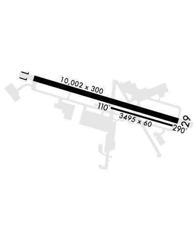
| Lat: N 3354.9 Long: W 08430.9 Elev: 1069 Var: +03 Longest Runway: 10002 | ||
| Dept. ATIS: 269.5 Arr. ATIS: 269.5 Ground: 125.3 Tower: 120.75 | ||
| ||||||
|
| Rwy | Rwy | |||||||
| 10002x300 | 10002' | 109.70 - 109° | 10002x300 | 10002' | 111.35 - 289° | |||
| 3495x60 | 3495' | 3495x60 | 3495' | |||||
| Runway ID | Single Wheel | Double Wheel | Double Tandem Wheel | Dual Double Wheel |
| 11/29 | N/A | N/A | N/A | N/A |
| 110/290 | N/A | N/A | N/A | N/A |
| These numbers are Advisory and are not limits. The Airport Manager should have more accurate Weight Limits | ||||
 Airport Diagram might not be current. | |
| Facility Name: | DOBBINS ARB |
| City Name: | MARIETTA |
| County: | COBB |
| State abbrev: | GA |
| State Name: | GEORGIA |
| Ownership: | AIR FORCE OWNED |
| Use: | PRIVATE |
| Owner's Name: | USAF |
| Address: | DOBBINS AFB |
| MARIETTA, GA 30060 | |
| Owner's Phone: | |
| Manager's Name: | CHIEF OF AFLD MANAGEMENT |
| Address: | DOBBINS AFB |
| MARIETTA, GA 30060 | |
| Phone: | |
| FAA Region: | SOUTHERN |
| FAA Field Office: | ATL |
| Date | Sunrise | Sunset |
|---|---|---|
| 09/24/21 Friday | 7:27 | 19:32 |
| 09/25/21 Saturday | 7:28 | 19:31 |
| 09/26/21 Sunday | 7:29 | 19:30 |
| 09/27/21 Monday | 7:29 | 19:28 |
| 09/28/21 Tuesday | 7:30 | 19:27 |
| 09/29/21 Wednesday | 7:31 | 19:25 |
| 09/30/21 Thursday | 7:32 | 19:24 |
| 10/01/21 Friday | 7:32 | 19:23 |
| 10/02/21 Saturday | 7:33 | 19:21 |
| 10/03/21 Sunday | 7:34 | 19:20 |
| 10/04/21 Monday | 7:34 | 19:19 |
| 10/05/21 Tuesday | 7:35 | 19:17 |
| 10/06/21 Wednesday | 7:36 | 19:16 |
| 10/07/21 Thursday | 7:37 | 19:15 |
| Airport Attendance Schedule | MON-FRI 1200-0400Z++ |
| Airport Status | OPERATIONAL (This Status can change at any time - please check NOTAMS) |
| Airport Lighting Schedule | |
| Airport Storage Available | NONE |
| Extra Services Available | Cargo Handling |
| Wind Indicator | YES - (unlit) |
| Control Tower | YES |
| CTAF Frequency | |
| Unicom Frequency | |
| Rotating Beacon Color | CLEAR-GREEN (Light Land Airport) |
| Segmented Circle | NO |
| Landing Fee |
| Airport Inspected | No Inspection Data Available performed by the OWNER |
| Inspection Date | Unknown |
| Type of Fuel Available | Grade 100LL, Grade 115, JET B (wide-cut turbine fuel, icing inhibitor, freeze point -50C) |
| Airframe Repair Service | MAJOR |
| Power Plant Repair Service | MAJOR |
| Latitude | N3354.9 |
| Longitude | W08430.9 (ESTIMATED) |
| Arpt Elevation | 1068ft (SURVEYED) |
| Magnetic Variation | 03W |
| 1 miles S | of MARIETTA |
| Traffic Pattern Altitude | TFC PAT: OVHD, ENTER INITIAL AT 3500 FT, DSND TO 2600 FT, LVL BRK AT RWY THLD. |
| Sectional Chart | ATLANTA |
| Operations (Reported) | Yearly | Avg. Daily |
|---|---|---|
| General Aviation Transient | 0 | 0 |
| General Aviation Local | 0 | 0 |
| Air Taxi | 0 | 0 |
| Commerical | 0 | 0 |
| Commuter | 0 | 0 |
| Military | 87297 | 239 |
| Aircraft based on Field | |
|---|---|
| General Aviation Singles | 0 |
| General Aviation Multi | 0 |
| Jet Aircraft | 0 |
| General Aviation Helicopters | 0 |
| Military Aircraft | 0 |
| Gliders | 0 |
| Ultralights | 0 |
| FSS on field | NO |
| FSS tie-in | MACON |
| FSS Phone | 1-800-WX-BRIEF |
| Who issues Notams | MGE |
| Notam D service at airport | YES |
| ARTCC Name | ATLANTA |
| Airport Certification | |
| Aircraft Rescue & Firefighting Index | None |
| Airport of Entry | No |
| Custom Landing Rights | No |
| Joint Civil/Military | No |
| Military Landing rights | No |
| LGT: FOR OLS RY 11-29 LCTN DATA SEE FLIP AP/1 SUPPLEMENTARY ARPT |
| JASU: 1(A/MA32A-86) 2(AM32-95) 3(A/M32A-86), 5(ESSEX B809). BASE ASGN ACFT HAVE PRIORITY. |
| FUEL: OPR 1100-0500Z++ MON-THU; 1100-0200Z++ FRI; 1100-0200Z++ SAT-SUN, EXP 1 HR FUEL DELAY. A++100. LHNIT |
| OIL: O-148-156 SOAP/JOAP, NO LAB SVC. |
| TRAN ALERT: OPR 1200-0400Z++ MON-SUN. LAVATORY SVC RQR 24 HR PN. DE ICE SVC. |
| ACFT-AIRCREWS DESIRING TO VISIT THE GEORGIA ARNG OR AASF#2, MUST LAND/PARK AT CLAY NATIONAL GUARD RAMP, 24 HR PPR REQ, CTC DSN 753-3500, C678-569-3500. SVC LIMITED TRANSIENT PARKING AVAILABLE. |
| AR-OPS CONTACT, DSN 625-9920/9921, C678-655-9920/9921 |
| RSTD: PPR CTC AMOPS AT DSN 625-4903, C678-655-4903. ACFT RSTD DUR BIRD WATCH COND MODERATE (TKOF/LDG PERMS WHEN DEP/ARR RTE AVOID IDENT BIRD ACT, NO LCL IFR/VFR TFC PAT ACFT) AND SEVERE (TKOF/LDG PROH WO 94TH OG/CC APVL), CTC AMOPS FOR CURRENT BIRD WATCH COND. |
| RSTD: HAZ CARGO RSTD TO C130 OR SMALLER ACFT. DO NOT TRANS ON HF WO TWR APVL. CTC AMOPS 20 MIN PRIOR TO LDG TO CONFIRM PPR AND SVCG/LOAD. TO PRK AF SIDE PPR, DSN 625-4903. ASSAULT LDG ZONE LCL USE ONLY. |
| MISC: WINDS ARE EST DUE TO FMQ-13 WIND SENSORS BEING ACCURATE TO WITHIN ONLY +/-4 KT. ATC/WX WILL NOT INCL/RELAY WIND CORR INTO FCST/PHRASEOLOGY. THEREFORE, AIRCREWS WILL INCORPORATE A +/- 4 KT ACCURACY INTO THEIR DECISION MAKING PROCESS FOR FLYING OPR. |
| MISC: BASE OPS DOES NOT ISSUE OR STOR COMSEC. RSRS APPLIED TO BASE ASGN ACFT ONLY; STD USAF RSRS NOT APPLICABLE. |
| MISC: AMOPS FAX DSN 625-4915. |
| RADAR: SEE TERMINAL FLIP FOR RADAR MINIMA. |
| MISC: RY 29 NON-STD APCH LIGHTS, STATION 1+00 NOT INSTALLED, STATION 2+00 CENTER LIGHT WRONG COLOR LENS. |
| OIL: NO LAB SVC. |
| RY 11/29 CLSD LAST SAT OF EACH MONTH FOR CONST 1200-2100Z++. |
| RSTD: PPR ONLY COORD/ISSUED 30 DAYS IN ADVANCE. |
| MISC: AFLD MGMT AND COMD POST DO NOT ISSUE OR STOR COMSEC. FOR STORAGE OF SMALL NON-COMSEC CLASSIFIED, 24 HOUR PN RQR, CTC COMD POST AT DSN 625-5106, C678-655-5106, MON-FRI, 1100-1500Z++, SAT-SUN, UNIT TRNG WKEND ONLY 1100-2000Z++. |
| RSTD: LOCKHEED MARTIN PPR FOR USE OF PARKING RAMPS OR FAC, C800-825-6083. |
| PMSV METRO: AWOS IN USE; AUGMENTED DUR AFLD OPR HRS. |
| RSTD: HOT CARGO PAD RQR 48 HR PN FOR USE. |
| FOR CD WHEN ATCT CLSD, CTC ATLANTA APCH AT 678-364-6132. |
| FLUID: LHNIT (LOW AND HI PRES NITROGEN SVCG). DE ICE (ANTI ICG/DE ICG/DEFRSTG FLUID (MIL-A-8243). |
| RWY 11/2 9 RWY 11/29 & VEDA ALZ CLSD LAST SAT EACH MONTH FOR MAINT, 1200-2100Z++. |
Airport Communications & Frequencies:
| |||||||||||||||||||||||||||
| Runway: 11 | Runway: 29 | ||
| Mag heading: | 109° | Mag heading: | 289° |
| Rwy Slope: | -.79% Down | Rwy Slope: | .79% Up |
| Approach: | LOC/GS | Approach: | LOC/GS |
| Pattern: | Left Traffic | Pattern: | Left Traffic |
| Markings: | Markings: | ||
| Marking Condition: | Marking Condition: | ||
| Arresting Dev: | Arresting Dev: | ||
| Lat & Long: | N3355.1 W08431.9 | Lat. & Long.: | N3354.7 W08430.0 |
| Elev: | 1068.5 ft. MSL | Elev: | 989.6 ft. MSL |
| TCH: | 55 ft. AGL | TCH: | 58 ft. AGL |
| Visual Glide Path: | 3.00 degrees | Visual Glide Path: | 3.00 degrees |
| Displaced Threshold: | No | Displaced Threshold: | No |
| Touchdown Zone: | YES | Touchdown Zone: | YES |
| Touchdown Elev.: | 1068.5 feet | Touchdown Elev.: | 1014.0 feet |
| Visual Glide Slope: | 4-Light PAPI on LEFT side of Runway | Visual Glide Slope: | 4-Light PAPI on LEFT side of Runway |
| RVR Equipment: | TOUCHDOWN | RVR Equipment: | TOUCHDOWN |
| RVV Equipment: | NO | RVV Equipment: | NO |
| Approach Lights: | ALSF1 - standard 2,400 foot high intensity approach lighting system with sequenced flashers, Category I | Approach Lights: | SALSF |
| REIL: | YES | REIL: | YES |
| Centerline Lights: | NO | Centerline Lights: | NO |
| Touchdown lights: | NO | Touchdown lights: | NO |
| Runway Category: | Runway Category: | ||
| Declared Distances: | Declared Distances: |
| Runway: 110 | Runway: 290 | ||
| Mag heading: | 109° | Mag heading: | 289° |
| Rwy Slope: | -.84% Down | Rwy Slope: | .84% Up |
| Approach: | Approach: | ||
| Pattern: | Left Traffic | Pattern: | Left Traffic |
| Markings: | Markings: | ||
| Marking Condition: | Marking Condition: | ||
| Arresting Dev: | Arresting Dev: | ||
| Lat & Long: | N3354.8 W08430.8 | Lat. & Long.: | N3354.6 W08430.2 |
| Elev: | 1019.1 ft. MSL | Elev: | 989.8 ft. MSL |
| TCH: | TCH: | ||
| Visual Glide Path: | Visual Glide Path: | ||
| Displaced Threshold: | No | Displaced Threshold: | No |
| Touchdown Zone: | NO | Touchdown Zone: | NO |
| Touchdown Elev.: | Touchdown Elev.: | ||
| Visual Glide Slope: | Visual Glide Slope: | ||
| RVR Equipment: | RVR Equipment: | ||
| RVV Equipment: | NO | RVV Equipment: | NO |
| Approach Lights: | Approach Lights: | ||
| REIL: | NO | REIL: | NO |
| Centerline Lights: | NO | Centerline Lights: | NO |
| Touchdown lights: | NO | Touchdown lights: | NO |
| Runway Category: | Runway Category: | ||
| Declared Distances: | Declared Distances: |
Thanks for using FltPlan.com
all rights reserved © 1999-2021 by Flight Plan LLC
