
| LAMPASAS LAMPASAS TX |
| |
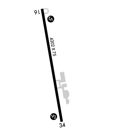
| Lat: N 3106.4 Long: W 09811.8 Elev: 1214 Var: -08 Longest Runway: 4202 | ||
| AWOS: 119.07 CTAF: 122.8 | ||
| ||||||
| ||||||
|
| Rwy | Rwy | |||||||
| 4202x75 | 4202' | 4202x75 | 4202' | |||||
| Runway ID | Single Wheel | Double Wheel | Double Tandem Wheel | Dual Double Wheel |
| 16/34 | 12,500 | N/A | N/A | N/A |
| These numbers are Advisory and are not limits. The Airport Manager should have more accurate Weight Limits | ||||
 Airport Diagram might not be current. | |
| Facility Name: | LAMPASAS |
| City Name: | LAMPASAS |
| County: | LAMPASAS |
| State abbrev: | TX |
| State Name: | TEXAS |
| Ownership: | PUBLICLY OWNED |
| Use: | OPEN TO THE PUBLIC |
| Owner's Name: | CITY OF LAMPASAS |
| Address: | 312 E. 3RD STREET |
| LAMPASAS, TX 76550 | |
| Owner's Phone: | 512-556-6831 |
| Manager's Name: | CHRIS EICLER |
| Address: | 312 E. 3RD STREET |
| LAMPASAS, TX 76550 | |
| Phone: | (512) 734-0228 |
| FAA Region: | SOUTHWEST |
| FAA Field Office: | TEX |
| Date | Sunrise | Sunset |
|---|---|---|
| 09/24/21 Friday | 7:22 | 19:27 |
| 09/25/21 Saturday | 7:23 | 19:26 |
| 09/26/21 Sunday | 7:23 | 19:24 |
| 09/27/21 Monday | 7:24 | 19:23 |
| 09/28/21 Tuesday | 7:24 | 19:22 |
| 09/29/21 Wednesday | 7:25 | 19:21 |
| 09/30/21 Thursday | 7:26 | 19:19 |
| 10/01/21 Friday | 7:26 | 19:18 |
| 10/02/21 Saturday | 7:27 | 19:17 |
| 10/03/21 Sunday | 7:28 | 19:16 |
| 10/04/21 Monday | 7:28 | 19:14 |
| 10/05/21 Tuesday | 7:29 | 19:13 |
| 10/06/21 Wednesday | 7:29 | 19:12 |
| 10/07/21 Thursday | 7:30 | 19:11 |
| Airport Attendance Schedule | UNATTENDED; FOR ATNDNT AFT HRS CALL 512-556-6235. |
| Airport Status | OPERATIONAL (This Status can change at any time - please check NOTAMS) |
| Airport Lighting Schedule | ACTVT MIRL RWY 16/34 - CTAF. |
| Airport Storage Available | Tie Downs |
| Extra Services Available | NONE |
| Wind Indicator | YES - (lighted) |
| Control Tower | NO |
| CTAF Frequency | 122.800 |
| Unicom Frequency | 122.800 |
| Rotating Beacon Color | CLEAR-GREEN (Light Land Airport) |
| Segmented Circle | YES |
| Landing Fee | NO |
| Airport Inspected | STATE - performed by PRIVATE CONTRACT PERSONNEL |
| Inspection Date | 05/15/2020 |
| Type of Fuel Available | Grade 100LL; -1024 HR SELF SVC CREDIT CARD FUEL AVBL. |
| Airframe Repair Service | None |
| Power Plant Repair Service | None |
| Latitude | N3106.4 |
| Longitude | W09811.8 (ESTIMATED) |
| Arpt Elevation | 1214ft (SURVEYED) |
| Magnetic Variation | 08E |
| 3 miles N | of LAMPASAS |
| Traffic Pattern Altitude | |
| Sectional Chart | SAN ANTONIO |
| Operations (Reported) | Yearly | Avg. Daily |
|---|---|---|
| General Aviation Transient | 2700 | 7 |
| General Aviation Local | 8100 | 22 |
| Air Taxi | 0 | 0 |
| Commerical | 0 | 0 |
| Commuter | 0 | 0 |
| Military | 0 | 0 |
| Aircraft based on Field | |
|---|---|
| General Aviation Singles | 11 |
| General Aviation Multi | 0 |
| Jet Aircraft | 0 |
| General Aviation Helicopters | 0 |
| Military Aircraft | 0 |
| Gliders | 0 |
| Ultralights | 0 |
| FSS on field | NO |
| FSS tie-in | SAN ANGELO |
| FSS Phone | 1-800-WX-BRIEF |
| Who issues Notams | SJT |
| Notam D service at airport | YES |
| ARTCC Name | HOUSTON |
| Airport Certification | |
| Aircraft Rescue & Firefighting Index | None |
| Airport of Entry | No |
| Custom Landing Rights | No |
| Joint Civil/Military | No |
| Military Landing rights | YES |
| NATIONAL PLAN OF INTEGRATED AIRPORT SYSTEMS (NPIAS) |
| ASSURANCES PURSUANT TO TITLE VI, CIVIL RIGHTS ACT OF 1964 |
| GRANT AGREEMENT HAS EXPIRED; HOWEVER, AGREEMENT REMAINS IN EFFECT FOR THIS FACILITY AS LONG AS IT IS PUBLIC USE. |
| DEER ON & INVOF ARPT. |
Airport Communications & Frequencies:
| ||||||||||||||
| Runway: 16 | Runway: 34 | ||
| Mag heading: | 163° | Mag heading: | 343° |
| Rwy Slope: | -1.38% Down | Rwy Slope: | 1.38% Up |
| Approach: | Approach: | ||
| Pattern: | Left Traffic | Pattern: | Left Traffic |
| Markings: | NONPRECISION INSTRUMENT | Markings: | NONPRECISION INSTRUMENT |
| Marking Condition: | GOOD | Marking Condition: | GOOD |
| Arresting Dev: | Arresting Dev: | ||
| Lat & Long: | N3106.7 W09811.8 | Lat. & Long.: | N3106.0 W09811.7 |
| Elev: | 1214.4 ft. MSL | Elev: | 1156.4 ft. MSL |
| TCH: | 40 ft. AGL | TCH: | 40 ft. AGL |
| Visual Glide Path: | 3.00 degrees | Visual Glide Path: | 3.00 degrees |
| Displaced Threshold: | No | Displaced Threshold: | No |
| Touchdown Zone: | YES | Touchdown Zone: | YES |
| Touchdown Elev.: | 1214.4 feet | Touchdown Elev.: | 1190.4 feet |
| Visual Glide Slope: | 2-Light PAPI on LEFT side of Runway | Visual Glide Slope: | 2-Light PAPI on LEFT side of Runway |
| RVR Equipment: | RVR Equipment: | ||
| RVV Equipment: | NO | RVV Equipment: | NO |
| Approach Lights: | Approach Lights: | ||
| REIL: | NO | REIL: | NO |
| Centerline Lights: | NO | Centerline Lights: | NO |
| Touchdown lights: | NO | Touchdown lights: | NO |
| Runway Category: | Runway with a Visual Approach | Runway Category: | Runway with a Non-precision Approach |
| Declared Distances: | Declared Distances: | ||
| Obstructions: | TREES | Obstructions: | TREE |
| Marked: | NOT Marked/Lighted | Marked: | NOT Marked/Lighted |
| Clearance slope: | Clearance slope: | 12:1 | |
| Obstruction height: | 20 feet AGL | Obstruction height: | 10 feet AGL |
| Dist. from runway: | 201 feet | Dist. from runway: | 320 feet |
| Centerline offset: | 170 right of centerline | Centerline offset: | 231 feet left of centerline |
| Comments: | 20 FT TREES 200 FT DSTC, 178 FT L. | Comments: | 20 FT TREES 103 FT DSTC THR 175 FT L. |
Thanks for using FltPlan.com
all rights reserved © 1999-2021 by Flight Plan LLC
