
| LEWISTON-NEZ PERCE COUNTY LEWISTON ID |
| |
| Lat: N 4622.5 Long: W 11700.9 Elev: 1442 Var: -15 Longest Runway: 6511 | ||
| AWOS: 135.57 Ground: 121.9 Tower: 119.4 | ||
| |||||||||||||||||||||||||||||||||||||||||||||||||||||||||||||||||||||
| |||||||||||||||||||||||||||||||||||||||||||||||||||||||||||||||||||||
| |||||||||||||||||||||||||||||||||||||||||||||||||||||||||||||||||||||
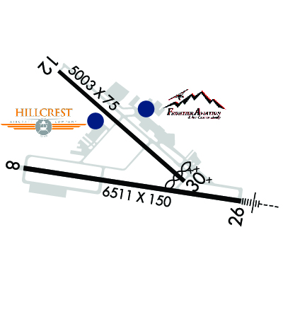
| Rwy | Rwy | |||||||
| 6511x150 | 6511' | 6511x150 | 6511' | 109.70 - 263° | ||||
| 5003x75 | 5003' | 5003x75 | 4750' | |||||
| Runway ID | Single Wheel | Double Wheel | Double Tandem Wheel | Dual Double Wheel |
| 08/26 | 120,000 | 250,000 | 550,000 | 1,076,000 |
| 12/30 | 97,000 | 169,000 | 309,000 | N/A |
| These numbers are Advisory and are not limits. The Airport Manager should have more accurate Weight Limits | ||||
 Airport Diagram might not be current. | |
| Facility Name: | LEWISTON/NEZ PERCE COUNTY |
| City Name: | LEWISTON |
| County: | NEZ PERCE |
| State abbrev: | ID |
| State Name: | IDAHO |
| Ownership: | PUBLICLY OWNED |
| Use: | OPEN TO THE PUBLIC |
| Owner's Name: | CITY OF LEWISTON/NEZ PERCE COUNTY |
| Address: | LEWISTON-NEZ PERCE COUNTY AIRPORT, 3632 STEARMAN STREET |
| LEWISTON, ID 83501 | |
| Owner's Phone: | 208-746-4471 |
| Manager's Name: | MIKE ISAACS |
| Address: | LEWISTON-NEZ PERCE COUNTY AIRPORT, 3632 STEARMAN ST |
| LEWISTON, ID 83501 | |
| Phone: | 208-748-9132 |
| FAA Region: | NORTHWEST MOUNTAIN |
| FAA Field Office: | HLN |

| Date | Sunrise | Sunset |
|---|---|---|
| 03/01/26 Sunday | 6:28 | 17:34 |
| 03/02/26 Monday | 6:26 | 17:36 |
| 03/03/26 Tuesday | 6:24 | 17:37 |
| 03/04/26 Wednesday | 6:22 | 17:38 |
| 03/05/26 Thursday | 6:20 | 17:40 |
| 03/06/26 Friday | 6:18 | 17:41 |
| 03/07/26 Saturday | 6:17 | 17:43 |
| 03/08/26 Sunday | 7:15 | 18:44 |
| 03/09/26 Monday | 7:13 | 18:45 |
| 03/10/26 Tuesday | 7:11 | 18:47 |
| 03/11/26 Wednesday | 7:09 | 18:48 |
| 03/12/26 Thursday | 7:07 | 18:50 |
| 03/13/26 Friday | 7:05 | 18:51 |
| 03/14/26 Saturday | 7:03 | 18:52 |
| Airport Attendance Schedule | 7 Days A Week 0530-2100 |
| Airport Status | OPERATIONAL (This Status can change at any time - please check NOTAMS) |
| Airport Lighting Schedule | WHEN ATCT CLSD ACTVT MALSR RWY 26; REIL RWY 08; PAPI RWY 12 & RWY 30 - CTAF. |
| Airport Storage Available | Tie Downs, Hanger |
| Extra Services Available | Air Freight, Crop Dusting, Air Ambulance, Cargo Handling, Charter, Flight Instruction, Aircraft Rental |
| Wind Indicator | YES - (lighted) |
| Control Tower | YES |
| CTAF Frequency | 119.400 |
| Unicom Frequency | 122.950 |
| Rotating Beacon Color | WG |
| Segmented Circle | YES |
| Landing Fee | NO |
| Airport Inspected | FEDERAL - performed by FAA AIRPORTS FIELD PERSONNEL |
| Inspection Date | 02/28/2024 |
| Type of Fuel Available | Grade 100, Grade 100LL, JET A (freeze point -40C) |
| Airframe Repair Service | MAJOR |
| Power Plant Repair Service | MAJOR |
| Latitude | N4622.5 |
| Longitude | W11700.9 (ESTIMATED) |
| Arpt Elevation | 1442ft (SURVEYED) |
| Magnetic Variation | 15E |
| 2 miles S | of LEWISTON |
| Traffic Pattern Altitude | TPA HVY AND TURBINE PWRD ACFT 1560 FT AGL ALL OTHERS 1060 FT AGL. |
| Sectional Chart | SEATTLE |
| Operations (Reported) | Yearly | Avg. Daily |
|---|---|---|
| General Aviation Transient | 0 | 0 |
| General Aviation Local | 0 | 0 |
| Air Taxi | 0 | 0 |
| Commerical | 0 | 0 |
| Commuter | 0 | 0 |
| Military | 0 | 0 |
| Aircraft based on Field | |
|---|---|
| General Aviation Singles | 0 |
| General Aviation Multi | 0 |
| Jet Aircraft | 0 |
| General Aviation Helicopters | 0 |
| Military Aircraft | 0 |
| Gliders | 0 |
| Ultralights | 0 |
| FSS on field | NO |
| FSS tie-in | BOISE |
| FSS Phone | 1-800-WX-BRIEF |
| Who issues Notams | LWS |
| Notam D service at airport | YES |
| ARTCC Name | SEATTLE |
| Airport Certification | AIRPORT RECEIVING SCHEDULED AIR CARRIER SERVICE FROM CARRIERS CERTIFICATED BY THE CIVIL AERONAUTICS BOARD; CLSD TO UNSKED ACR OPNS WITH MORE THAN 30 PSGR SEATS EXCP PPR CALL AMGR 208-790-1050. |
| Aircraft Rescue & Firefighting Index | AIRPORT HAS A CERTIFICATE UNDER CFR PART 139 |
| Airport of Entry | No |
| Custom Landing Rights | No |
| Joint Civil/Military | No |
| Military Landing rights | YES |
| NATIONAL PLAN OF INTEGRATED AIRPORT SYSTEMS (NPIAS) |
| GRANT AGREEMENTS UNDER FAAP/ADAP/AIP |
| ASSURANCES PURSUANT TO TITLE VI, CIVIL RIGHTS ACT OF 1964 |
| AGREEMENT UNDER DLAND OR DCLA HAS EXPIRED. |
| (E94) LAWRS |
| FREQUENT NO RADIO AGRICULTURAL ACFT ACTIVITY IN VICINITY OF ARPT. |
| FOR CD IF UNA TO CTC ON FSS FREQ, CTC SEATTLE ARTCC AT 253-351-3694. |
| LWS APN E HNGR RAMP CLSD TO ACRS EXC GA AND ACFT WINGSPAN LESS THAN 58 FT. |
| RWY 08/2 6 PCR VALUE: 720/F/B/X/T |
| RWY 12/3 0 PCR VALUE: 360/F/A/X/T |
Airport Communications & Frequencies:
| |||||||||||||||||||
| Runway: 08 | Runway: 26 | ||
| Mag heading: | 84° | Mag heading: | 264° |
| Rwy Slope: | .10% Up | Rwy Slope: | -.10% Down |
| Approach: | Approach: | ILS | |
| Pattern: | Right Traffic | Pattern: | Left Traffic |
| Markings: | NONPRECISION INSTRUMENT | Markings: | PRECISION INSTRUMENT |
| Marking Condition: | GOOD | Marking Condition: | GOOD |
| Arresting Dev: | Arresting Dev: | ||
| Lat & Long: | N4622.4 W11701.7 | Lat. & Long.: | N4622.3 W11700.1 |
| Elev: | 1427.1 ft. MSL | Elev: | 1433.3 ft. MSL |
| TCH: | 45 ft. AGL | TCH: | 51 ft. AGL |
| Visual Glide Path: | 3.00 degrees | Visual Glide Path: | 3.00 degrees |
| Displaced Threshold: | No | Displaced Threshold: | No |
| Touchdown Zone: | YES | Touchdown Zone: | YES |
| Touchdown Elev.: | 1440.4 feet | Touchdown Elev.: | 1441.9 feet |
| Visual Glide Slope: | 4-BOX VASI ON LEFT SIDE OF RUNWAY | Visual Glide Slope: | 4-Light PAPI on LEFT side of Runway |
| RVR Equipment: | RVR Equipment: | ||
| RVV Equipment: | NO | RVV Equipment: | NO |
| Approach Lights: | Approach Lights: | MALSR - 1,400 foot medium intensity approach lighting system with runway alignment indicator lights | |
| REIL: | YES | REIL: | NO |
| Centerline Lights: | NO | Centerline Lights: | NO |
| Touchdown lights: | NO | Touchdown lights: | NO |
| Runway Category: | Runway with a Non-precision Approach having visibility minimums greater than 3/4 mile | Runway Category: | Precision Instrument Runway |
| Declared Distances: | TORA:6511' TODA:6511' ASDA:6511' LDA:6511' | Declared Distances: | TORA:6511' TODA:6511' ASDA:6511' LDA:6511' |
| Obstructions: | Obstructions: | TREE | |
| Marked: | Marked: | NOT Marked/Lighted | |
| Clearance slope: | 34:1 | Clearance slope: | 35:1 |
| Obstruction height: | Obstruction height: | 185 feet AGL | |
| Dist. from runway: | Dist. from runway: | 6500 feet | |
| Centerline offset: | Centerline offset: | 250 feet right of centerline | |
| Comments: | Comments: |
| Runway: 12 | Runway: 30 | ||
| Mag heading: | 117° | Mag heading: | 297° |
| Rwy Slope: | 1.44% Up | Rwy Slope: | -1.44% Down |
| Approach: | Approach: | ||
| Pattern: | Right Traffic | Pattern: | Left Traffic |
| Markings: | NONPRECISION INSTRUMENT | Markings: | NONPRECISION INSTRUMENT |
| Marking Condition: | GOOD | Marking Condition: | GOOD |
| Arresting Dev: | Arresting Dev: | ||
| Lat & Long: | N4622.9 W11701.4 | Lat. & Long.: | N4622.4 W11700.5 |
| Elev: | 1370.3 ft. MSL | Elev: | 1442.1 ft. MSL |
| TCH: | 40 ft. AGL | TCH: | 45 ft. AGL |
| Visual Glide Path: | 3.00 degrees | Visual Glide Path: | 3.00 degrees |
| Displaced Threshold: | No | Displaced Threshold: | 253 feet |
| Touchdown Zone: | YES | Touchdown Zone: | YES |
| Touchdown Elev.: | 1416.4 feet | Touchdown Elev.: | 1439.2 feet |
| Visual Glide Slope: | 2-Light PAPI on LEFT side of Runway; PAPI UNUSBL BYD 3.5 NM. | Visual Glide Slope: | 2-Light PAPI on LEFT side of Runway |
| RVR Equipment: | RVR Equipment: | ||
| RVV Equipment: | NO | RVV Equipment: | NO |
| Approach Lights: | Approach Lights: | ||
| REIL: | YES | REIL: | NO |
| Centerline Lights: | NO | Centerline Lights: | NO |
| Touchdown lights: | NO | Touchdown lights: | NO |
| Runway Category: | Runway with a Non-precision Approach having visibility minimums greater than 3/4 mile | Runway Category: | Runway with a Non-precision Approach having visibility minimums greater than 3/4 mile |
| Declared Distances: | TORA:5003' TODA:5003' ASDA:4750' LDA:4750' | Declared Distances: | TORA:5003' TODA:5003' ASDA:5003' LDA:4750' |
| Obstructions: | Obstructions: | ANT | |
| Marked: | Marked: | LIGHTED | |
| Clearance slope: | 34:1 | Clearance slope: | 30:1 |
| Obstruction height: | Obstruction height: | 33 feet AGL | |
| Dist. from runway: | Dist. from runway: | 500 feet | |
| Centerline offset: | Centerline offset: | ||
| Comments: | Comments: |
Thanks for using FltPlan.com
all rights reserved © 1999-2026 by Flight Plan LLC


